Subscribe to be notified if similar examples become available.
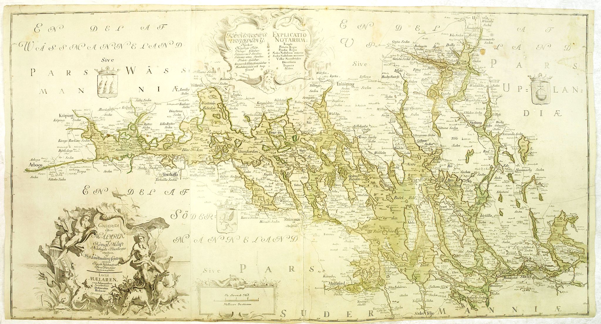
Charta öfwer Mälaren, med Kongl: Maj.ts. nådigste privilegio utgifven af Kong:e Landtmäteri Contoiret. |
||||||||||||||||||||
|
||||||||||||||||||||
|
|
||||||||||||||||||||
|
Selling price: $ Please login to see price!
Sold in 2015 Missed this item! Add your name to our mailing list and be the first to get notified about our newly added listings. . |
My Collection +
Add this or any of your favorite items in one place. If you want to save the items permanently, you have to sign in or create an account first. |
|||||||||||||||||||
Description
A scarce map of the district of Mälaren Sweden. A large title cartouche upper left and a key in the lower left corner.
The map is a part of a work by Kongl. Landtmäteri Contoiret and its associates published in the years 1739-1793, covering parts of Sweden, Finland and the Baltic States. Engraved by E. Geringius a Swedish engraver and mapmaker.
This was the first effort to map the country in somewhat uniform maps. The first map to be published in 1739, was the grand "Charta öfwer Mälaren" by Jacob Nordencreutz. The maps Upland, Västmanland, Södermanland, Nerike, Skåne and a general map of Sweden followed in the 1740s and early 1750s.
Few copies of these early maps were sold and the endeavor came to a halt due to economic difficulties. After some years, the next map to be published was the 1769 map of Medelpad. The remaining maps were then published during the next twenty-five years.
The last map "Charta öfver Heinola Höfdingedöme" was issued in 1793. Many parts of Sweden were never covered (Öland, Gotland, Halland, Herjedalen and Norrbotten). Since the project was unfinished, it was never sold as a proper atlas.
The few atlases that do exist are compilations. The general map of 1747 by Biurman is a milestone in Swedish cartography. It replaces Bureus1626 map as a blue print of Sweden for foreign cartographers. (In the mid 1790s Samuel Gustaf Hermelin launched a private attempt to map the country, this time with success. All of Sweden and Finland was mapped by 1818.
FAQ - Guarantee - Shipping
Buying in the BuyNow Gallery
This item is available for immediate purchase when a "Add to Cart" or "Inquire Now" button is shown.
Items are sold in the EU margin scheme
Payments are accepted in Euros or US Dollars.
Authenticity Guarantee
 We provide professional descriptions, condition report (based on 45 years experience in the map business)
Paulus Swaen warrants the authenticity of our items and a certificate of authenticity is provided for each acquired lot.
Condition and Coloring
We indicate the condition of each item and use our unnique HiBCoR grading system in which four key items determine a map's value: Historical Importance, Beauty, Condition/Coloring and Rarity.
Color Key
We offer many maps in their original black and white condition. We do not systematically color-up maps to make them more sellable to the general public or buyer.
Copper engraved or wood block maps are always hand colored. Maps were initially colored for aesthetic reasons and to improve readability. Nowadays, it is becoming a challenge to find maps in their original colors and are therefor more valuable.
We use the following color keys in our catalog:
Original colors; mean that the colors have been applied around the time the map was issued.
Original o/l colors; means the map has only the borders colored at the time of publication.
Colored; If the colors are applied recently or at the end of the 20th century.
Read more about coloring of maps [+]
Shipping fee
A flat shipping fee of $ 30 is added to each shipment by DHL within Europe and North America. This covers : International Priority shipping, Packing and Insurance (up to the invoice amount).
Shipments to Asia are $ 40 and rest of the world $50
We charge only one shipping fee when you have been successful on multiple items or when you want to combine gallery and auction purchases.
Read more about invoicing and shipping
FAQ
Please have a look for more information about buying in the BuyNow gallery
Many answers are likely to find in the general help section.
My Collection+
![]()
With My Collection+ you can collect all your favorite items in one place. It is free, and anyone can create his or her virtual collection.
Unless you are logged in, the item is only saved for this session. You have to be registed and logged-in if you want to save this item permanently to My Collection+.
Read More[+]
Register here, it is free and you do not need a credit card.
Add this item to
My Collection+
or click the following link to see My Collection+.
| Digital Image Download | |
|
Paulus Swaen maintains an archive of most of our high-resolution rare maps, prints, posters and medieval manuscript scans. We make them freely available for download and study. Read more about free image download |
Click the image for a free small image download. |
In accordance with the EU Consumer Rights Directive and habitually reside in the European Union you have the right to cancel the contract for the purchase of a lot, without giving any reason.
The cancellation period will expire 14 calendar days from the day after the date on which you or a third party (other than the carrier and indicated by you) acquires, physical possession of the lot. To exercise the right to cancel you must inform Paulus Swaen Inc, of your decision to cancel this contract by a clear statement (e.g. a letter sent by post, or e-mail.
To meet the cancellation deadline, it is sufficient for you to send your communication concerning your exercise of the right to cancel before the cancellation period has expired.
