Browse Listings
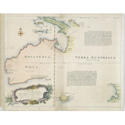
A Complete Map of the Southern Continent Survey'd by Capt. Abel Tasman & depicted by Order of the East Indian Company in Holland In The Stadt House at Amsterdam.
The first large-scale English map, one devoted to Tasman's discoveries on both his voyages. Noted on the map are the promises of riches that are certain to be discovered ...
Date: London, 1744
Selling price: ????
Please login to see price!
Sold in 2009
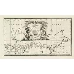
An exact chart of the countries through which Capt. Behring travelled from Tobolsky capital of Siberia ti the country of Kamtschatka.
The earliest English language map to show Vitus Behring's Route.After retiring from a tour as Captain in the Czar's Navy, Behring, originally from Denmark, settled in Vyb...
Date: London, 1744
Selling price: ????
Please login to see price!
Sold in 2013
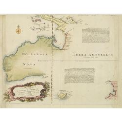
A Complete Map of the Southern Continent Survey'd by Capt. Abel Tasman & depicted by Order of the East Indian Cmpany in Holland In The Stadt House at Amsterdam.
The first large-scale English map devoted to Tasman's discoveries on both his voyages. Noted on the map are the promises of riches that are certain to be discovered by vi...
Date: London, 1744
Selling price: ????
Please login to see price!
Sold in 2010
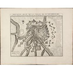
Nouveau Plan De La Ville De Luxembourg. Ville Forte et Capitale du Duche ... 1744
A quite scarce and impressive plan of Luxembourg by Covens & Mortier. Based on the plan of Baillieu 1705/10, but with new fortification as mentioned in the key '23. N...
Date: Amsterdam, 1744
Selling price: ????
Please login to see price!
Sold in 2010
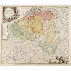
Arena Martis in Belgio qua provinciae X catholicae. . .
Johann Baptist Homann's well-engraved map of Belgium, southern part of the Netherlands and Luxembourg. With two fine decorative title cartouche, one with miniature panora...
Date: Neurenberg 1744
Selling price: ????
Please login to see price!
Sold in 2011
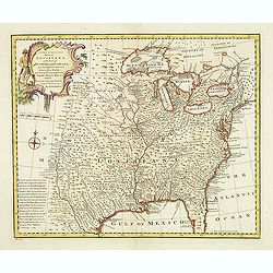
A new & accurate map of Louisiana, with part of Florida. . .
An English view of North America compiled from available French maps, especially those of Bellin used in Charlevoix's History of New Franc. English cartographers had litt...
Date: London, 1744
Selling price: ????
Please login to see price!
Sold in 2020
Cartes Des Provinces Des Pays Bas Contenant les Comte´s de Flandre, de Hainaut, Cambresis, le Duche´ de Brabant. . .
Fricx was a book seller and publisher active in Brussels. He issued maps from 1703 onwards and is best known for his maps of the military campaigns of the War of the Span...
Date: Paris, Crepy, 1744
Selling price: ????
Please login to see price!
Sold in 2014
Mappe Monde Nouvelle Dediee a Monseigneur le Comte de Maurepas Ministre...
A very large world map superbly decorated. Issued in 1744, it shows many important details: California has rejoined the mainland, however, further north there is still a ...
Date: Paris, 1744
Selling price: ????
Please login to see price!
Sold in 2013
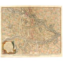
Plan of the Lines of Brabant forced July 18, 1705
This map of Brabant, Belgium is from Paul de Rapin's “The History of England” written in French by Mr. Rapin de Thoyras. The map represents a battle that took place d...
Date: London, 1744
Selling price: ????
Please login to see price!
Sold in 2023
Four Regional Maps of Germany.
Four decorative regional maps of Germany including the North-East, Sout-East,North-West and South-West parts. each is decorated with a fancy cartouche. Emanuel Bowen (171...
Date: London, ca. 1744
Selling price: ????
Please login to see price!
Sold in 2016
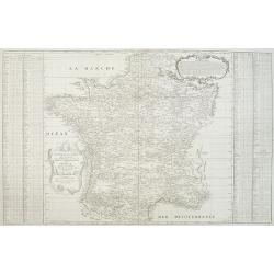
Nouvelle carte qui comprend les principaux Triangles qui servent de Fondement à la Description géométrique de la France. . .
Detailed map of France, showing city of Paris, Calais, Perigueux, Nantes, Marseille, Avignon, Reims…To the left and to the right 2 cartouches with the list of principal...
Date: Paris, ca. 1744
Selling price: ????
Please login to see price!
Sold
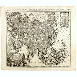
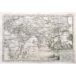
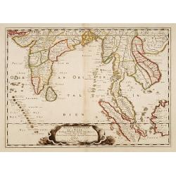
Asia secundum legitimas projectionis stereographicae.
Highlighted area covers part of Spain, eastern coast of Ireland to western part of Papua New Guinea and the Asian continent from the Northern Polar Sea to the Indian Ocea...
Date: Nurenberg, 1744
Selling price: ????
Please login to see price!
Sold in 2014
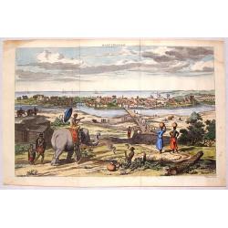
Masulipatnam.
Fine hand-colored copper engraving of a view of the city of Masulipatnam on the Malibar Coast in India. It was published in "THE TRUE & EXACT DESCRIPTION OF THE ...
Date: London, 1744
Selling price: ????
Please login to see price!
Sold in 2015
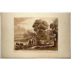
Shepherds With Cattle & Goats Meeting - Plate #41.
This is a mezzotint print after Claude Lorrain. His paintings were etched masterfully by another great artist: Richard Earlom, who had specialized in the most royal of pr...
Date: London, 1744
Selling price: ????
Please login to see price!
Sold in 2016
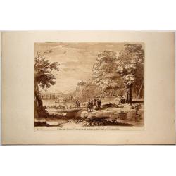
Man Tied To Tree - Plate #45.
This is a mezzotint print by Claude Lorrain. His paintings were etched masterfully by another great artist: Richard Earlom, who had specialized in the most royal of print...
Date: London, 1744
Selling price: ????
Please login to see price!
Sold in 2016
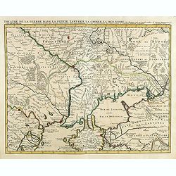
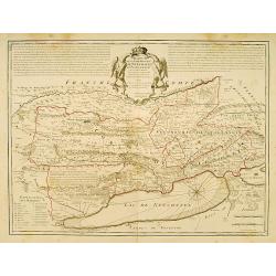
Theatre de la Guerre Dans la Petite Tartarie, La Crimee, la Mer Noire, &c..
Detailed map prepared by Guillaume Delisle focusing on the Black Sea with wonderful detail of the surrounding regions. Shows watershed, villages and cities, mountains. Lo...
Date: Amsterdam c. 1744
Selling price: ????
Please login to see price!
Sold in 2014
![[2 maps and one text sheet] Theatrum Belli A° MDCCXXXVII. . . / Verus Chersonesi Tauricae Seu Crimea Conspectus adjacentium item Regionem itinerisq ab Exercitu Ruthemo Ao MDCCXXXVI et MDCCXXXVII adversus Tattaros Susceptis . . .](/uploads/cache/35503-250x250.jpg)
[2 maps and one text sheet] Theatrum Belli A° MDCCXXXVII. . . / Verus Chersonesi Tauricae Seu Crimea Conspectus adjacentium item Regionem itinerisq ab Exercitu Ruthemo Ao MDCCXXXVI et MDCCXXXVII adversus Tattaros Susceptis . . .
Set of 2 copper engraved maps and a text sheet from the observations of Guillaume de l'Isle for the St.Petersburg' Academie des Sciences. Set of maps of part of the Ukrai...
Date: Amsterdam, ca. 1744
Selling price: ????
Please login to see price!
Sold in 2015
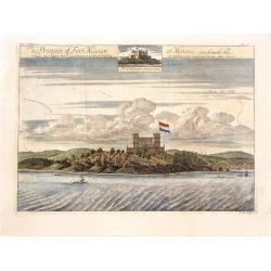
The Prospect of Fort Nassaw at Mouree, Seen from the Sea.
A fine copper engraved print featuring a scene of Fort Nassaw in Guinea. From John Barbot's "A Description of Nort and South Guinea" published in London in 1744...
Date: London, 1744
Selling price: ????
Please login to see price!
Sold in 2015
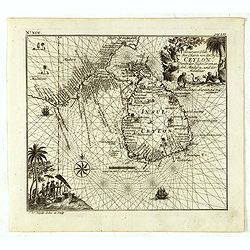
Accurater Plan u See-Charte von der Insul Ceylon..
Decorative map of Ceylon and southern tip of India. Rare, from Allerneuster geographisch- und topographischer Schau-Platz von Africa und Ost-Indien.
Date: Germany, 1744
Selling price: ????
Please login to see price!
Sold in 2015
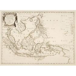
![No title. [South East Asia]](/uploads/cache/36593-250x250.jpg)
No title. [South East Asia]
Including Indonesia, India, Java, Sumatra, Japan, Taiwan and North coast of Australia. Rare, from Allerneuster geographisch- und topographischer Schau-Platz von Africa un...
Date: Germany, 1744
Selling price: ????
Please login to see price!
Sold in 2015
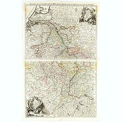
(Two sheet map) Theatre de la Guerre sur le Rhin, sur la Meuse, sur la Moselle, et sur le Neckre.
Fine map of the northern part of the River Rhine, in Germany and The Netherlands, with a splendidly engraved cartouche.From his rare atlas "Theatre de la Guerre en A...
Date: Paris, 1744
Selling price: ????
Please login to see price!
Sold in 2017
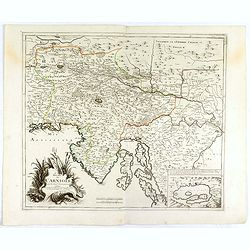
Le Duché de Carniole. . .
Fine map of part of Italy with Istria and part of Slovenia with a splendid cartouche. With inset of "Lake de Gireknitz" in lower right corner. From his rare atl...
Date: Paris, 1744
Selling price: ????
Please login to see price!
Sold in 2016
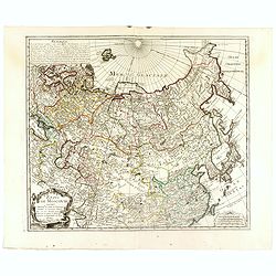
Etats de Moscovie. . .
Fine and rare map of Russia, Siberia, China, Korea and Japan. George Louis Le Rouge was active between 1740 and 1780, in Paris at, rue des Augustins as a publisher, and w...
Date: Paris, 1744
Selling price: ????
Please login to see price!
Sold in 2023
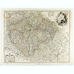
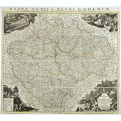
Le Royaume de Boheme. Carte reduite sur celle de 25 feuilles faite a Prague, par Müller, a Paris. Par et chez le sieur leRouge Ingr. Géographe du Roy . . .
Uncommon general map of the Czech Republic, centered on Prague. Prepared after the 25 sheet wall map of J.C. Müller, and published by Le Rouge. Folio maps by Le Rouge ar...
Date: Paris, 1744
Selling price: ????
Please login to see price!
Sold in 2016
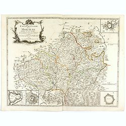
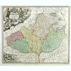
Carte particulière de la Moravie Divisée en six Cercles avec les Principaux Postes de ce Marquisat, pour l'intelligence de la Guerre présente . . .
Fine map of Moravia which occupies most of the eastern part of the Czech Republic, including the South Moravian Region, the Zlín Region, vast majority of the Olomouc Reg...
Date: Paris, 1744
Selling price: ????
Please login to see price!
Sold in 2016
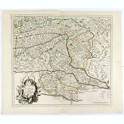
Le duché de Stirie. . .
Fine map of part of Austria with a splendid cartouche. George Louis Le Rouge was active between 1740 and 1780, in Paris at, rue des Augustins as a publisher, and was appo...
Date: Paris, 1744
Selling price: ????
Please login to see price!
Sold in 2016
L'Archeveché de Saltzbourg dedié A S.A.S. Monseigneur le Prince de Conty, . .
Fine map of part of Austria and centered on Salzburg with a splendid title, scale and key cartouches. George Louis Le Rouge was active between 1740 and 1780, in Paris at,...
Date: Paris, 1744
Selling price: ????
Please login to see price!
Sold in 2016
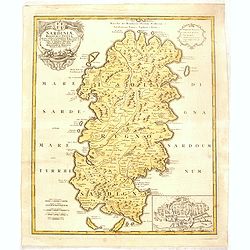
Sardiniae regnum et Insula..
Johann Baptist Homann's well-engraved map has a large decorative cartouche and inset plan of Porto Vecchio (Cagliari). Detailed map of Sardinia.Johann Baptist Homann (166...
Date: Nuremberg, 1744
Selling price: ????
Please login to see price!
Sold in 2016
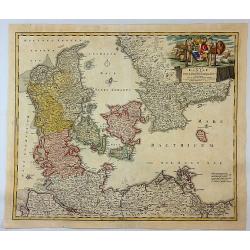
Regni Daniae.
Johann Baptist Homann's well-engraved map of Denmark, Schleswig-Holstein and Mecklenburg in Germany. With a fine decorative title cartouche featuring animals and two men ...
Date: Nuremberg, 1744
Selling price: ????
Please login to see price!
Sold in 2018
Le royaume de Boheme divisée en ses douzes cercles. . .
Highly detailed copper-engraved map of Bohemia centered on Prague, which is a reduced version of the 25 sheets map by Johann Christoph Müller (1673-1721).Ornated with de...
Date: Amsterdam, ca. 1744
Selling price: ????
Please login to see price!
Sold in 2017
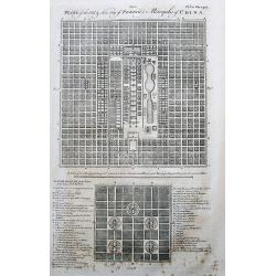
Plans of the Old & New City of Peking ye Metropolis of China.
Two plans of the city, on top new Peking, and below ancient Peking. An extensive legend key identifies around 49 important places such as the Emperor’s residence, remar...
Date: London, 1744
Selling price: ????
Please login to see price!
Sold in 2017
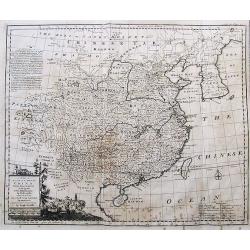
A New & Accurate Map of China.
Emanuel Bowen's map of China based on D'Anville's earlier work.Includes the Korean peninsula, Formosa (Taiwan), and Hainan. With an explanation legend, and text informati...
Date: London, 1744
Selling price: ????
Please login to see price!
Sold in 2017
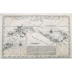
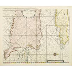
A Map of the Discoveries made by Captain William Dampier in the Roebuck in 1699.
The map shows the route of William Dampier around Timor until New Guinea, around New Britain and back along the coasts of New Guinea.Published in John Harris important wo...
Date: London, 1744
Selling price: ????
Please login to see price!
Sold in 2017
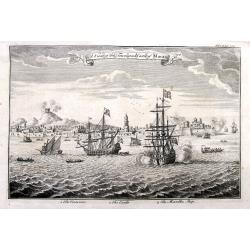
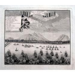
A View of the Town and Castle of Macao.
Nice view of the town seen from the sea. Numerous buildings and ships shown. With the British ship Centurion in the foreground firing cannons, and the return fire is seen...
Date: London, 1744
Selling price: ????
Please login to see price!
Sold in 2018
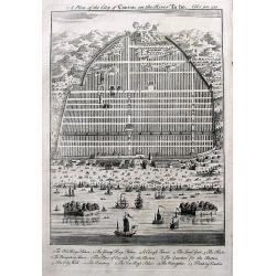
A Plan of the City of Canton on the River Ta ho.
An early plan of Guangzhou, with many buildings and ships shown. A key names 13 places, including the King's Palace, Young Kings's Palace, The City Wall, and two Floating...
Date: London, 1744
Selling price: ????
Please login to see price!
Sold in 2017
A Map of Marco Polo's Voyages & Travels in the 13th Century through a great part of Asia, all Tartary, the East India Islands & Part of Africa.
This unusual map depicts the areas in Asia where Marco Polo traveled in the 13th century. Japan is shown as a peninsula connected to Land of Yeso! With a decorative title...
Date: London, 1744
Selling price: ????
Please login to see price!
Sold in 2017
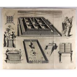
Solomon Built the House of the lord on the Mount Where the Lord Appeared to David His Father. II Chronicle, Chapter III, Verse 1.
A fine religious print from a Bible in 1762. There are eight separate images including “The Temple of Solomon”, "The Tabernacle in the Wilderness", "Th...
Date: London, 1744
Selling price: ????
Please login to see price!
Sold in 2019
Ein Prospect der Stadt Batavia, wie sich dieselbe von der Reede oder dem Hafen praesentiret.
An uncommon view of Batavia (today known as Jakarta) shown from the sea, which was the main city of the Dutch East India Company (the VOC). The harbour is filled with sai...
Date: Nuremberg, 1744
Selling price: ????
Please login to see price!
Sold in 2018
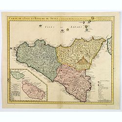
Carte de l'Isle et Royaume de Sicile Par Guillaume del 'Isle . . .
A detailed and rare issue of this map of Sicily prepared by de L'Isle, highlighted by some beautiful rendering of Mt. Etna. An inset map of the islands of Malta and Gozzo...
Date: Amsterdam ca 1744
Selling price: ????
Please login to see price!
Sold in 2021
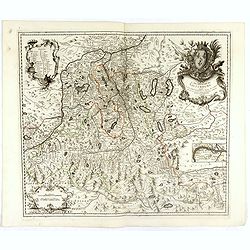
Tabula Generalis Marchionatus Moraviae..
Johann Baptist Homann's well-engraved map has a large decorative cartouche. Detailed map of the present-day Jihormoravsky region centred on Brno.Johann Baptist Homann (16...
Date: Nuremberg 1744
Selling price: ????
Please login to see price!
Sold in 2018
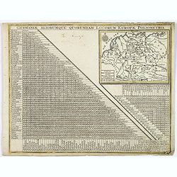
Germaniae Aliorumque Quorundam Locorum Europae Poliometria.
An interesting and detailed mileage table and map of Germany, by Lotter. It shows the distances from various points in Germany and the Low Countries to the major cities i...
Date: Augsburg, 1744
Selling price: ????
Please login to see price!
Sold in 2020
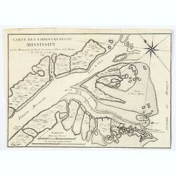
Carte des Embouchures du Mississipi.
This is a lovely chart of the mouth of the mighty Mississippi River, and her delta, as it empties into the Gulf of Mexico, about 75 miles south east of New Orleans. The c...
Date: Paris, ca 1744
Selling price: ????
Please login to see price!
Sold in 2020
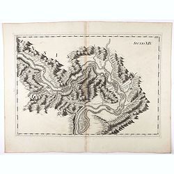
Sectio XIV.
Map of part of the Danube showing section in Romania. Prepared by Count Luigi Ferdinando Marsili (1658 - 1730) who was an Italian scholar and eminent natural scientist. P...
Date: Amsterdam, 1744
Selling price: ????
Please login to see price!
Sold in 2020
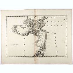
Tab : IV. (Danube)
Map of part of the Danube River showing section in Germany with Weitzen, etc. Prepared by Count Luigi Ferdinando Marsili (1658 - 1730) who was an Italian scholar and emin...
Date: Amsterdam, 1744
Selling price: ????
Please login to see price!
Sold in 2020
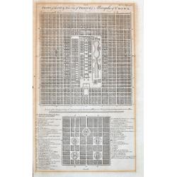
Plans of the Old & New City of Peking ye Metropolis of China.
Two early plans of the city, on top the new Peking, and below the ancient Peking. With an extensive legend key that identifies around 49 important places such as the Empe...
Date: London, 1744
Selling price: ????
Please login to see price!
Sold in 2021
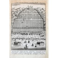
A Plan of the City of Canton on the River Ta ho.
An early and decorative plan of Guangzhou, with many buildings and ships shown. A key names 13 places, including the King's Palace, Young Kings's Palace, The City Wall, a...
Date: London, 1744
Selling price: ????
Please login to see price!
Sold in 2021
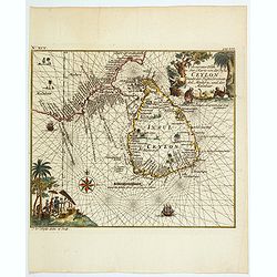
Accurater Plan u See-Charte von der Inful Ceylon..
A fine and decorative map of Ceylon and southern tip of India, presented as a sea chart. Scarce. From Allerneuster geographisch- und topographischer Schau-Platz von Afric...
Date: Germany, 1744
Selling price: ????
Please login to see price!
Sold in 2021
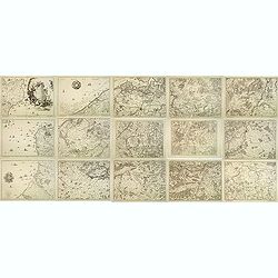
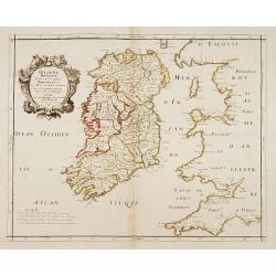
![[The Plans of the Principal Towns, Forts & Harbours in Ireland]](/uploads/cache/47406-250x250.jpg)
[The Plans of the Principal Towns, Forts & Harbours in Ireland]
A selection of 16 city views (Kilkenny), town plans (Dublin, Londonderry, Coleraine, Gallway, Carrickfergus, Cork, Athlone, Waterford, Belfast, Limerick), forts (Drogheda...
Date: London , 1744
Selling price: ????
Please login to see price!
Sold in 2021
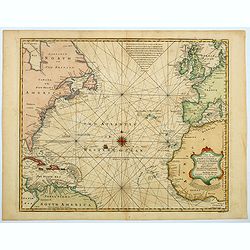
A New and Accurate Chart of the Western or Atlantic Ocean. . .
A map that is typical of the sort published by Emanuel Bowen. This chart of the Western or Atlantic Ocean contains numerous annotations, which lend a fascination and char...
Date: London, 1744
Selling price: ????
Please login to see price!
Sold in 2023
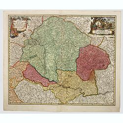
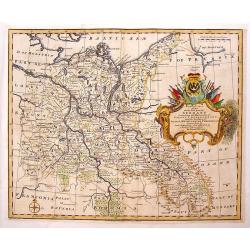
Regni Hungariae tabula generalis. . .
Johann Baptist Homann's well-engraved map of Hungary. With a fine decorative title cartouche and another hunting cartouche in the opposite corner housing the mileage scal...
Date: Neurenberg, 1744
Selling price: ????
Please login to see price!
Sold in 2023
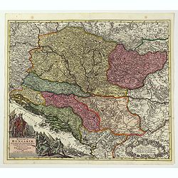
Regnorum Hungariae, Dalmatiae, Croatiae. . .
Johann Baptist Homann's well-engraved map of Hungary. With a fine decorative title cartouche showing the Hapsburg victors of war and the vanquihsed Ottomans in equal meas...
Date: Nuremberg, 1744
Selling price: ????
Please login to see price!
Sold in 2022
![[Title page] Atlas Minor Praecipua Orbis Terrarum Imperia, Regna et Provincias , Germaniae Potissimum. . .](/uploads/cache/48385-250x250.jpg)
[Title page] Atlas Minor Praecipua Orbis Terrarum Imperia, Regna et Provincias , Germaniae Potissimum. . .
An attractive and highly decorative title page to Seutter's Atlas Minor. Engraved by Martin Crophius after Jacob Weyerman. The engraving is packed with lively figures fro...
Date: Augsburg, 1744
Selling price: ????
Please login to see price!
Sold in 2022
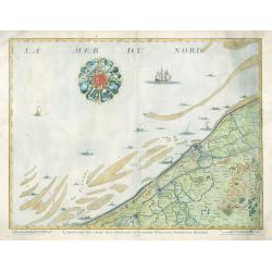
Carte Particuliere Des Environs D'Ostende Neuport Furnes et Autres
This is a seldom seen map of the coast of Belgium by one of the most prolific Belgian publishers of the 18th century, Eugène-Henri Fricx (1644-1740 c.). The map feature...
Date: Brussels, 1744
Selling price: ????
Please login to see price!
Sold in 2023
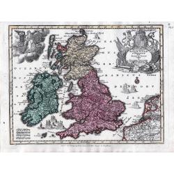
Accuratissima Angliae, Scotiae et Hiberniae tab., …
An elegant map of the British Isles. From: Atlas Minor Praecipua Orbis Terrarum Imperia, Regna et Provincias, Germania, … The maps were drawn by Georg Matheus Seutt...
Date: Augsburg, circa 1744
Selling price: ????
Please login to see price!
Sold in 2023
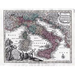
Nova Totius Italiae cum adjacentibus majoribus et minorib insulis tabula …
A detailed map of Italy and the islands of Corsica, Sardinia and Sicily together with its possessions along the Dalmatian coastFrom: Atlas Minor Praecipua Orbis Terrarum ...
Date: Augsburg, circa 1744
Selling price: ????
Please login to see price!
Sold in 2023
Carte de la Louisiane et du cours du Mississipi . . .
Covens & Mortier's issue of Delisle's influential map of the French possession of Louisiana. Updated to include New Orleans.When originally published in 1718, it was ...
Date: Amsterdam, 1745
Selling price: ????
Please login to see price!
Sold in 2020
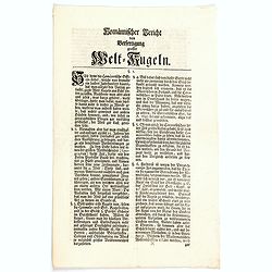
Homannischer Bericht von Berfertigung grosser Welt-Kugeln.
Homannian report of the production of large globes, a small four page, sixteen point document detailing the production for making large globes.
Date: Nuremberg, 1745
Selling price: ????
Please login to see price!
Sold in 2020
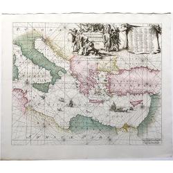
Orientalior Districtus Maris Mediterranei / t'Ooster Gedeelte van de Middelandse Zee.
A sea chart of the Eastern Mediterranean, from Sardinia and Corsica to Syria and the Holy Land, centered on Greece. A very nice cartouche at top centre depicting a confro...
Date: Amsterdam, 1745
Selling price: ????
Please login to see price!
Sold in 2020
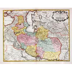
Carte de Perse.
A fine and detailed map of Iran, Iraq, and eastern Turkey. Published by P. Starckman and published by P.Buache in 1745.Guillaume de l'Isle (1675-1724), Royal Geographer, ...
Date: Paris, 1745
Selling price: ????
Please login to see price!
Sold in 2021
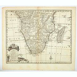
A New & Accurate Map of the Southern Parts of Africa containing Lower Guinea, Monoemugi. . .
A striking map of the Southern half of Africa and Madagascar, complete with a large decorative cartouche and compass rose. Tribal regions and Kingdoms named. Interesting ...
Date: London, ca 1745
Selling price: ????
Please login to see price!
Sold in 2021
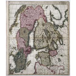
Sueciae Magnae, totius Orbis Regni antiquissimi, hodierna in sex Principales suas partes, Gothiam nempe, Sueciam propriam sive strictae Sumptam, Nordlandiam, Ingriam, Livoniam', and impressum...
Map of Greater Sweden: Sweden, Finland, Estonia, Latvia. From: Atlas sive Geographia compendiosa ... / Atlas Nouveau contenant tous les partis du Monde (Composite Atlas),...
Date: Amsterdam, ca. 1745
Selling price: ????
Please login to see price!
Sold in 2022
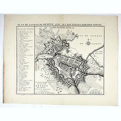
Plan de la ville de Geneve, avec ses nouvelles Fortifications.
A beautifully engraved, highly decorative map showing all of Geneva extended to Leman lake, with excellent map detail throughout. Major cities and towns, with regional ro...
Date: Amsterdam, ca 1745
Selling price: ????
Please login to see price!
Sold in 2022
Casaniae Regnum cum Adiacentibus Provinciis et Parte Fluvii Volgae.
From the first regional atlas of Russia, published by the Academy of Sciences in St. Petersburg, expanding on the cartographic work done previously by Ivan K. Kirilov. Ou...
Date: Academy of Sciences, St. Petersburg, 1745
Selling price: ????
Please login to see price!
Sold in 2025
![[Lot of 11 maps of Russia]](/uploads/cache/48304-250x250.jpg)
[Lot of 11 maps of Russia]
Lot of 11 maps of Russia, diiferent size, diofferent dates.
Date: Augsburg, 1745
Selling price: ????
Please login to see price!
Sold in 2022
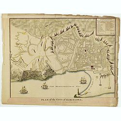
Plan of the City of Barcelona.
From Rapin's History of England , a nicely detailed plan of Barcelona, the capital of Catalonia. The plate contains a 19 point legend and the presentation is enhanced wit...
Date: London, c.1745

Half length portrait of Abbé Prévost.
Very fine half length portrait of Abbé Prévost, author of Histoire Généale des Voyages. Engraved by G.F.Schmidt in Berlin. In the background a globe and several book ...
Date: Paris, 1745
Selling price: ????
Please login to see price!
Sold
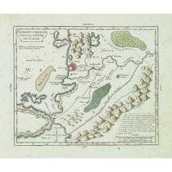
A large Draught of the East End of Java and Madura. . .
Oriented with west at the top, this large-scale and detailed chart of the Bali Strait and Java Sea, shows the eastern ends of Java and Madura, and the western end of Bali...
Date: London 1745
Selling price: ????
Please login to see price!
Sold in 2023
Introduction à la conoissance et à l'usage des cartes.
This copper engraved map is a guidance on how to use the maps in his "Atlas portatif, universel et militaire, composé d'après les meilleures cartes, . . .".In...
Date: Paris, c. 1745
Selling price: ????
Please login to see price!
Sold in 2013
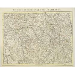
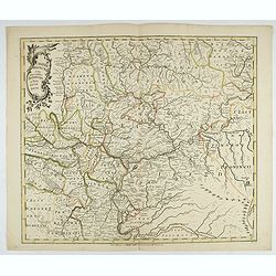
Partie Meridionale De Champagne. . .
Very detailed, topographical map of the southern Champagne. Showing fortified cities, roads, towns, rivers, lakes, forests, etc. The map is from a Dutch edition of De L'I...
Date: Amsterdam c. 1745
Selling price: ????
Please login to see price!
Sold
Partie Meridionale de l'Inde en deux presqu'isles..
An uncommon late printing of the Sanson's important mid-seventeenth century map of India and Southeast Asia, with the engraved date 1703 (apparently the second and last s...
Date: Paris 1703/c.1745
Selling price: ????
Please login to see price!
Sold
Les Isles Philippines Molucques et de la Sonde.
An uncommon late printing of Sanson's important mid-seventeenth century map of the East Indies, covering modern Indonesia, the Philippines, Malaysia and parts of Southeas...
Date: Paris 1654/c.1745
Selling price: ????
Please login to see price!
Sold
Irlande Royaume divisé en ses quatre Provinces..
SANSON'S MAP OF IRELAND IN ITS THIRD AND RAREST STATE BY GILLES ROBERT.Sanson's 1665 map of Ireland, in it THIRD AND RAREST STATE, with the 1741 imprint of Gilles Robert....
Date: Paris 1741/c.1745
Selling price: ????
Please login to see price!
Sold
A large Draught from Benjar on the Island of Borneo..
A later edition, printers address erased from the title cartouche. Latitude scale, compass rose and system of rhumb lines, soundings near coast.
Date: London 1745
Selling price: ????
Please login to see price!
Sold
Le Gouvern.t Général du Dauphiné. . .
With decorative cartouche with dolphins.
Date: Paris, 1745
Selling price: ????
Please login to see price!
Sold
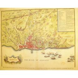
Plan of the city and Castle of Alicant..
A handsome and highly decorative plan of the town of Alicante in south-eastern Spain. The piece contains a 35 point legend along with a cartouche and sailing ships in bat...
Date: London, c. 1745
Selling price: ????
Please login to see price!
Sold
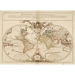
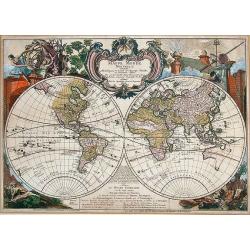
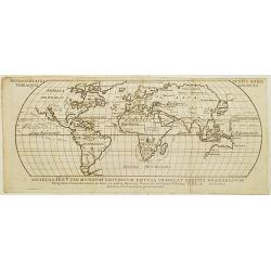
Mappe-Monde Geo-Hydrographique, ou Description Generale..
"MAP OF THE WORLD DEDICATED TO LOUIS XIV.Large map of the world in two hemispheres, in a stereographic projection (each hemisphere 31.5 cm in diameter). California s...
Date: Paris 1741/c.1745
Selling price: ????
Please login to see price!
Sold
"Plan of Attack of Camaret Bay, on the Coast of Bretagne ..."
An interesting and attractive map of Camaret bay in Brittany. The piece depicts a battle scene between British and French naval forces in the vicinity of Brest.It feature...
Date: London, ca 1745
Selling price: ????
Please login to see price!
Sold in 2008
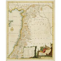
A map of the Holy Land and Syria.
Uncommon map of the Holy Land. With a key and decorative title cartouche in bottom. Published in Description of the East .
Date: London 1745
Selling price: ????
Please login to see price!
Sold
Carte de la Souveraineté de Neufchatel et de Vallangin..
Very beautiful map of Neufchatel in Switzerland, prepared by David François de Merveilleux in 1710.
Date: Paris, 1745
Selling price: ????
Please login to see price!
Sold
Repraesentatio totius orbis terraoquei cogniti..
Engraved by Joannes Petroschi for Descripcion de la Provincias del Chaco y confinantes segun las relaciones.. De los Missionaros de la Compania de Jesus. In the oceans th...
Date: Rome c. 1745
Selling price: ????
Please login to see price!
Sold