Browse Listings
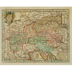
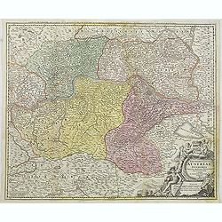
Teutschlandes Oesterreichischer Creiss..
Uncommon map of Austria. The originally colored title cartouche is surrounded by floral decorations. From Atlas Portatif.
Date: Nuremberg 1724
Selling price: ????
Please login to see price!
Sold
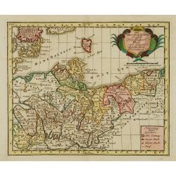
Des OberSächßischen Creißes Nordlicher Theil..
Uncommon map of Obersachsen. With originally colored title cartouche. From Atlas Portatif.
Date: Nuremberg 1724
Selling price: ????
Please login to see price!
Sold
Extract einer General Post-Charte..
Uncommon post route map of Germany. With originally colored title cartouche. From Atlas Portatif.
Date: Nuremberg 1724
Selling price: ????
Please login to see price!
Sold
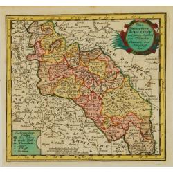
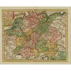
Das Hertzogthum Schlesien..
Uncommon map of Northern Germany. The originally colored title cartouche. From Atlas Portatif.
Date: Nuremberg 1724
Selling price: ????
Please login to see price!
Sold
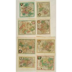
8 Maps of German provinces..
Group of 8 uncommon maps of German provinces. With originally colored title cartouches. From Atlas Portatif.
Date: Nuremberg 1724
Selling price: ????
Please login to see price!
Sold
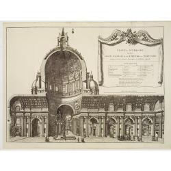
Veduta interiore.. Gran Basilica di S.Pietro in Vaticano.
A beautifully engraved and richly decorated architectural print of the interior of St.Pieter Church in Rome. With a key (a-z) in lower corners.Joan Blaeu published during...
Date: Amsterdam, 1663/1704/1724
Selling price: ????
Please login to see price!
Sold
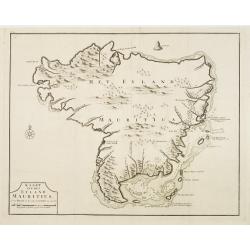
Kaart van het eyland Mauritius.
Fine map depicting the island of Mauritius. Little interior detail is given but the coastlines, settlements and principal coastal features are identified. An attractive e...
Date: Amsterdam 1724
Selling price: ????
Please login to see price!
Sold
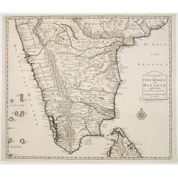
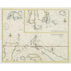
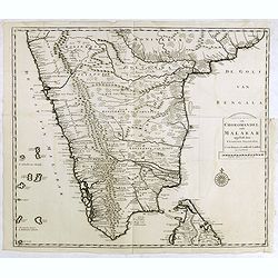
Nieuwe Kaart van Choromandel ende Malabar..
Fine map depicting the southern part of India and the northern tip of Ceylon. Much detail is given along the coastlines, settlements and principal coastal features are id...
Date: Amsterdam 1724
Selling price: ????
Please login to see price!
Sold
Des OberSächßischen Creißes Nordlicher Theil..
Uncommon map of Obersachsen. The originally colored title cartouche is surrounded by mythological figures. From Atlas Portatif.
Date: Nuremberg 1724
Selling price: ????
Please login to see price!
Sold in 2015
De Landvoogdy der Moluccos..
Fine chart depicting the Moluccas islands. Little interior detail is given but the coastlines, settlements and principal coastal features are identified. To the lower rig...
Date: Amsterdam, 1724
Selling price: ????
Please login to see price!
Sold in 2008
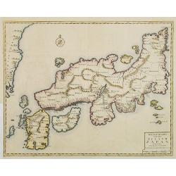
Nieuwe kaart van het eyland Japan.
The map originally appeared in Valentijn's book Oud en Nieuw Oost-Indien (Dordrecht/Amsterdam 1724/26). With in the right bottom corner the imprint J.van Braam en G. onde...
Date: Amsterdam, 1724
Selling price: ????
Please login to see price!
Sold in 2008
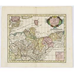
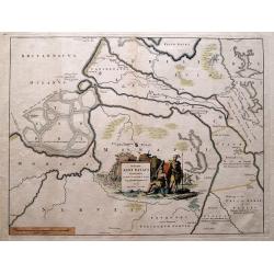
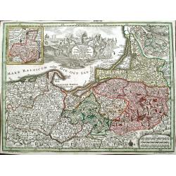
Archiducatus Austriae inferioris . . .
Decorative map of Austria, centered on the course of the Danube River and Vienna. Shows the region from Enss and sTeyr to Presburg and Altenburg.
Date: Nuremberg, 1724
Selling price: ????
Please login to see price!
Sold in 2014
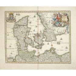
Dania Jutia Holsatia, Scandia...
An attractive map of Denmark and adjacent coastlines. Includes elaborate cartouche and 2 coats of arms.Nice old coloring, drawn and engraved by Michael Kauffer.(inscripti...
Date: Nuremberg, 1724
Selling price: ????
Please login to see price!
Sold in 2012
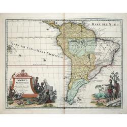
AMERICA MERIDIONALIS.
Very attractive map of the continent of South America with typical 18th century cartography, much of it fanciful. The large pictorial title cartouche features the peoples...
Date: Nuremberg, 1724
Selling price: ????
Please login to see price!
Sold in 2012
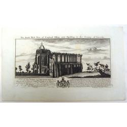
The South East View of Croyland Abbey Near Spalding, in the County of Lincoln.
A fine copper engraving by the Buck Brothers for The Right Honorable John Lord Brownlowe. These are the rmains of an abbey that was founded in the year 716. Samuel and ...
Date: London, 1724
Selling price: ????
Please login to see price!
Sold in 2013
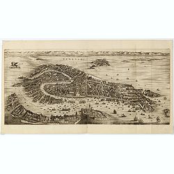
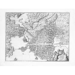
Venetia.
Folding panoramic view showing in great detail the harbour and city of Venice.Engraved in 1670 by Julius Milheuser but it was never used in an atlas and only a few copies...
Date: Amsterdam, 1704-1724
Selling price: ????
Please login to see price!
Sold in 2015
Nieuwe Kaart van Choromandel ende Malabar..
Fine map depicting the southern part of India and the northern tip of Ceylon. Much detail is given along the coastlines, settlements and principal coastal features are id...
Date: Amsterdam, 1724
Selling price: ????
Please login to see price!
Sold in 2015
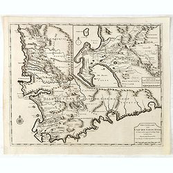
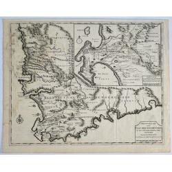
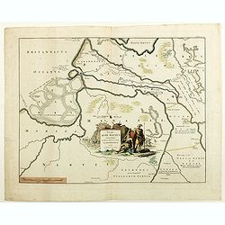
Nieuwe Kaart van Caap der Goede Hoop in hare rechte jegenwoordige staat. . .
Fine map depicting the southern tip of Africa. Little interior detail is given but the coastlines, settlements and principal coastal features are identified. In top right...
Date: Amsterdam, 1724
Selling price: ????
Please login to see price!
Sold in 2015
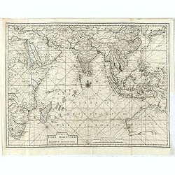
Tabula Indiae Orientalis et regnorum adjacentium.
Highly detailed map of Australia, Southeast Asia and the Indian Ocean depicting the working area of the V.O.C. The map originally appeared in Valentijn's book Oud en Nieu...
Date: Amsterdam, 1724
Selling price: ????
Please login to see price!
Sold in 2015

La Perse La Georgie, La Natolie Les Arabies...
A very rare map of the Arabian Peninsular, Turkey, Persia. Prepared by Nicolas de Fer, issued by G.Danet. The title is enhanced with gold.
Date: Paris, 1724
Selling price: ????
Please login to see price!
Sold in 2017
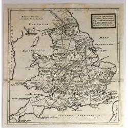
In Gratiam Itinerantium Curiosorum Antonini Aug. Itinerarium per Britanniam.
An informative map of Great Britain, showing roads, rivers, cities and towns. Place names given in both Latin and English.Published by Herman Moll in 1724 in “A New Des...
Date: London, 1724
Selling price: ????
Please login to see price!
Sold in 2016
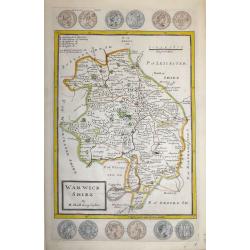
Warwick Shire by H. Moll Geographer
An interesting and attractive 18th century copperplate map of the county of Warwickshire divided into hundreds.It shows a title panel, scale and lists the administrative ...
Date: London, 1724
Selling price: ????
Please login to see price!
Sold in 2016
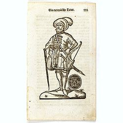
Ein Europäische Tatar.
Finely executed wood block print taken from the "Neueröffnetes Amphitheatrum Worinnen. . .", which book was issued in five parts between 1722 and 1728, with vo...
Date: Erfurt, ca. 1724
Selling price: ????
Please login to see price!
Sold in 2016
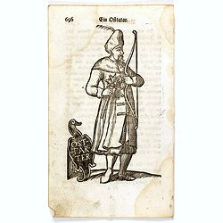
Ein Ostarter.
Finely executed wood block print taken from the "Neueröffnetes Amphitheatrum Worinnen. . .", which book was issued in five parts between 1722 and 1728, with vo...
Date: Erfurt, ca. 1724
Selling price: ????
Please login to see price!
Sold in 2016
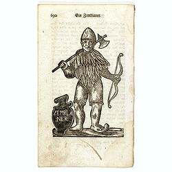
Ein Zemblaner.
Finely executed wood block print taken from the "Neueröffnetes Amphitheatrum Worinnen. . .", which book was issued in five parts between 1722 and 1728, with vo...
Date: Erfurt, ca. 1724
Selling price: ????
Please login to see price!
Sold in 2016
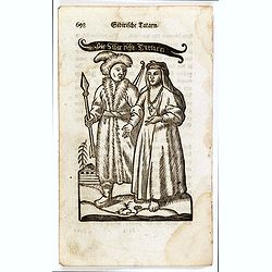
Siberifche Tartarn.
Finely executed wood block print taken from the "Neueröffnetes Amphitheatrum Worinnen. . .", which book was issued in five parts between 1722 and 1728, with vo...
Date: Erfurt, ca. 1724
Selling price: ????
Please login to see price!
Sold in 2016
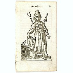
Ein Russe.
Finely executed wood block print taken from the "Neueröffnetes Amphitheatrum Worinnen. . .", which book was issued in five parts between 1722 and 1728, with vo...
Date: Erfurt, ca. 1724
Selling price: ????
Please login to see price!
Sold in 2016
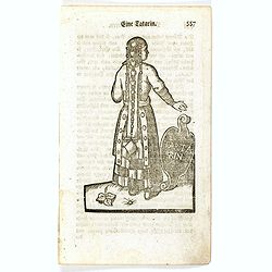
Eine Tartarin.
Finely executed wood block print taken from the "Neueröffnetes Amphitheatrum Worinnen. . .", which book was issued in five parts between 1722 and 1728, with vo...
Date: Erfurt, ca. 1724
Selling price: ????
Please login to see price!
Sold in 2016
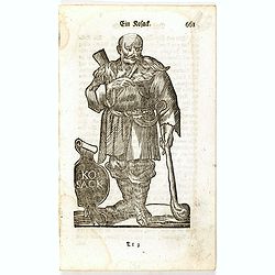
Ein Kosack.
Finely executed wood block print taken from the "Neueröffnetes Amphitheatrum Worinnen. . .", which book was issued in five parts between 1722 and 1728, with vo...
Date: Erfurt, ca. 1724
Selling price: ????
Please login to see price!
Sold in 2016
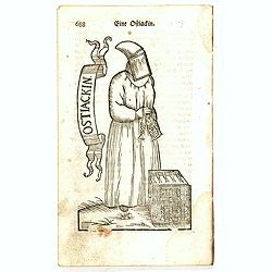
Eine Ostiackin.
Finely executed wood block print taken from the "Neueröffnetes Amphitheatrum Worinnen. . .", which book was issued in five parts between 1722 and 1728, with vo...
Date: Erfurt, ca. 1724
Selling price: ????
Please login to see price!
Sold in 2016
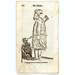
Ein Ostiacke.
Finely executed wood block print taken from the "Neueröffnetes Amphitheatrum Worinnen. . .", which book was issued in five parts between 1722 and 1728, with vo...
Date: Erfurt, ca. 1724
Selling price: ????
Please login to see price!
Sold in 2016
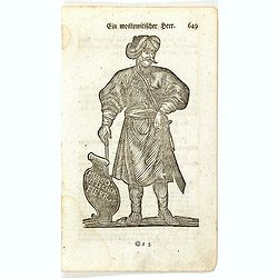
Ein Muscovitischer Herr.
Finely executed wood block print taken from the "Neueröffnetes Amphitheatrum Worinnen. . .", which book was issued in five parts between 1722 and 1728, with vo...
Date: Erfurt, ca. 1724
Selling price: ????
Please login to see price!
Sold in 2016
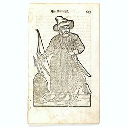
Ein Samojed.
Finely executed wood block print taken from the "Neueröffnetes Amphitheatrum Worinnen. . .", which book was issued in five parts between 1722 and 1728, with vo...
Date: Erfurt, ca. 1724
Selling price: ????
Please login to see price!
Sold in 2016
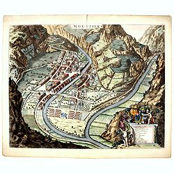
Moustiers.
A beautifully engraved and richly decorated plan of Moustiers. A key (A-Q) in the lower part refers to the principal places of interest in the town.Joan Blaeu published d...
Date: Amsterdam, 1724
Selling price: ????
Please login to see price!
Sold in 2016
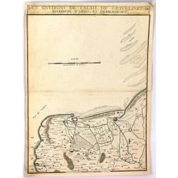
Les Environs de Calais, Gravelines, Bourbourg, d'Ardes, et d'Embleteuse & c.
A map showing the border between France and the Netherlands near Calais, Gravelines, Bourbourg, Ardes, and Embleteuse, by Nicolas de Fer, published in Paris in 1724. It w...
Date: Paris, 1724
Selling price: ????
Please login to see price!
Sold in 2018
![Lucon of Luconia. [ Map of the Philippines]](/uploads/cache/39345-250x250.jpg)
Lucon of Luconia. [ Map of the Philippines]
Fine chart depicting the Islands of the Philippines. Little interior detail is given but the coastlines, settlements and principal coastal features are identified. An att...
Date: Amsterdam, 1724
Selling price: ????
Please login to see price!
Sold in 2017
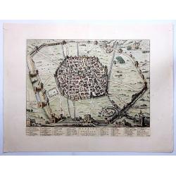
Felsina Sive Bononia Antiqua...
A very detailed copper engraved plan of ancient Bologna, from Johannes Blaeu's scarce series of Italy town books. Published by Pierre Mortier. Willem Janszoon Blaeu (157...
Date: Amsterdam, 1663-1724
Selling price: ????
Please login to see price!
Sold in 2023
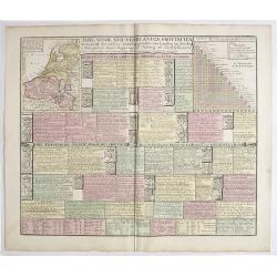
Tafel vande XVII Nederlandze Provincien, Vertonende der zelver verdeling, grootte van Landen en Steden, mids-gaders haar Regering, zo Politicq als Kerk-lyck, en veel andere merkweerdige zaken, ten nutte vande Historien en Geographie.
Interesting engraving, showing description and crests of the 17 Dutch provinces, the major cities and towns, political and religious diversity, trades, inventions and VOC...
Date: Amsterdam, 1724
Selling price: ????
Please login to see price!
Sold in 2019
Nieuw Kaart van Caap Der Goede Hoop - in hare rechte jegenwoordige staat vertoond door FRANÇOIS VALENTYN.
An attractive & detailed map of the Cape region, one of the few early Dutch maps to focus on the region only some 70 years after the first Dutch settlement. Area cove...
Date: Amsterdam, 1724
Selling price: ????
Please login to see price!
Sold in 2019
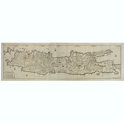
Nieuwe en zeer naaukeurige kaart van t eyland Java Major of Groot Java : verdeeld in seven byzondere bestekken. . .
This large-scale map of Java is richly engraved with details of agricultural fields, roads, temples, and topography. The coastline is filled with soundings, anchorages, s...
Date: Amsterdam, 1724
Selling price: ????
Please login to see price!
Sold in 2020
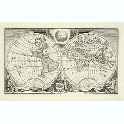
De Aard-Kloot, Volgens de Hedendaagse Gedaante.
An unusual world map showing California as an island and a rudimentary form of Australia. Tucked into the cusps of the double hemisphere map is a very inventive depiction...
Date: Amsterdam, c.1725
Selling price: ????
Please login to see price!
Sold in 2012
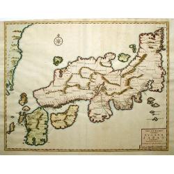
Nieuwe Kaart van het Eyland Japan...
This copper engraved map of Japan divides the country by provinces, and extends to show the eastern border of Korea. Only the mountain ranges are depicted in the interior...
Date: Amsterdam, 1725
Selling price: ????
Please login to see price!
Sold in 2014
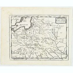
A new map of Poland from the latest Obser.ns
Uncommon map of Poland and Lithuania. In upper right corner "front Page 137". Published in "Patrick Gordon's Geography Anatomiz'd" by John Senex.
Date: London, J. Senex, ca. 1725
Selling price: ????
Please login to see price!
Sold in 2012
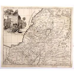
A Map of the Holy Land Divided Into the XII Tribes of Israel.
A copper engraved featuring the Holy Land with the travels of Jesus marked. The map is enhanced by a large figural cartouche with Jesus healing Lazarus. A detailed map di...
Date: London, c1725
Selling price: ????
Please login to see price!
Sold in 2018
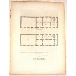
Plan of the First & Second Floors of Bobham Hall.
Interesting copper engraving featuring architectural plans for a famous building in Kent.Colen Campbell (1676 – 1729) was a pioneering Scottish architect and architect...
Date: London, c1725
Selling price: ????
Please login to see price!
Sold in 2015
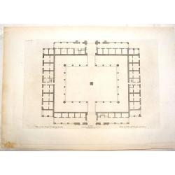
Plan of the Royal Echange, London.
Striking architectural plan for the British Sock Exchange Building. Colen Campbell (1676–1729) was a pioneering Scottish architect and architectural writer, credited as...
Date: London, c1725
Selling price: ????
Please login to see price!
Sold in 2016
Descriptio Agri Batavi Aliorumque qui hodie cis Rhenum in dicione VII Foedereratorum Auctore Mensone Alting.
Unusual map of Zeeland and Flanders with ancient names. With good detail on rivers and islands. Decorated with numerous warriors engaged in battle.
Date: Amsterdam, 1725
Selling price: ????
Please login to see price!
Sold in 2014
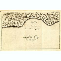
Baye de Matecalo Dans l'Isle de Ceylon / Partie du Golfe de Bengale. ( Tome 2 Page 417)
Uncommon map of the Bay of Matecalo on Ceylon in the Gulf of Bengal. From the French reissue of the account of early Dutch voyages first published in 1608 by Commelin. Th...
Date: Amsterdam, F. Bernard, 1725
Selling price: ????
Please login to see price!
Sold in 2022
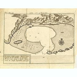
St Helene.
Uncommon small map of St. Helena, with two coastal profile inset maps.From the French reissue of the account of early Dutch voyages first published in 1608 by Commelin. T...
Date: Amsterdam, F. Bernard, 1725
Selling price: ????
Please login to see price!
Sold in 2019
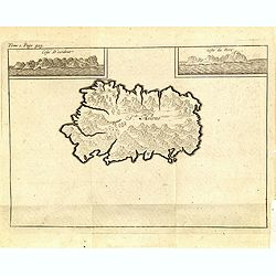
Isle St. Maurice. Ins. cygnae a Lusit, a nostris Maurity nomine indigitata, sita ad 21um gradum ab Equinoctiali Meridiem versus inventa et detecta Decima-jctava die mensis septembris anno 1598.
A bay at ST. Mauritius, a small island located in the South-West Indian Ocean, off the east coast of Madagascar. Mauritius is well known for the Dodo, the extinct bird. T...
Date: Amsterdam, F. Bernard, 1725
Selling price: ????
Please login to see price!
Sold in 2019
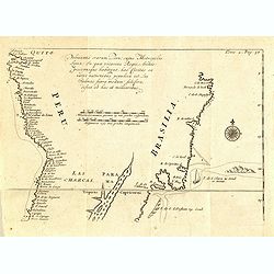
Pelineatis anarium Peru cujus Metropolis Lima : In qua vicarus Regis, Archie piscopusque . . . . ( Tome 2 Page 48)
Uncommon map of the central part of South America with Peru, Brasil. Only coastal names.From the French reissue of the account of early Dutch voyages first published in 1...
Date: Amsterdam, F. Bernard, 1725
Selling price: ????
Please login to see price!
Sold in 2017
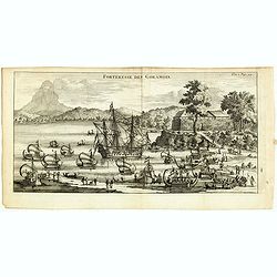
Forteresse des Goramois.
Showing a view of the fortress of Goram. From the French reissue of the account of early Dutch voyages first published in 1608 by Commelin. The French translation was car...
Date: Amsterdam, F. Bernard, 1725
Selling price: ????
Please login to see price!
Sold in 2016
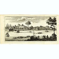
Cranganor.
This view of Cranganor in the state of Kerala in southwestern India. From the French reissue of the account of early Dutch voyages first published in 1608 by Commelin. Th...
Date: Amsterdam, F. Bernard, 1725
Selling price: ????
Please login to see price!
Sold in 2019
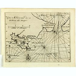
Côté méridional de la Terre Del Fuego.
Uncommon map of the southern most tip of Tiera del Fuego. From the French reissue of the account of early Dutch voyages first published in 1608 by Commelin. The French tr...
Date: Amsterdam, F. Bernard, 1725
Selling price: ????
Please login to see price!
Sold in 2017
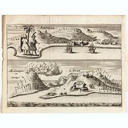
Amboyna. / I.Neri.
Fine engraving of the Dutch and English enclaves at Amboyna (top) and Banda-Neira (bottom). From the French reissue of the account of early Dutch voyages first published ...
Date: Amsterdam, F. Bernard, 1725
Selling price: ????
Please login to see price!
Sold in 2016
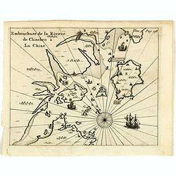
Embouchure de la rivière de Chincheo à la Chine.
This map is a view of Quanzhou Bay. Quanzhou was established in 718 during the Tang Dynasty (618–907). In those days, Guangzhou was China's greatest seaport, but this s...
Date: Amsterdam, F. Bernard, 1725
Selling price: ????
Please login to see price!
Sold in 2014
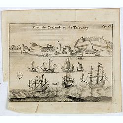
Fort de Zeelande ou de Taiovang.
Rare view of Fort Zeelandia, which was a fortress built over ten years from 1624–1634 by the Dutch East India Company, in the town of Anping (Tainan) on the island of F...
Date: Amsterdam, F. Bernard, 1725
Selling price: ????
Please login to see price!
Sold in 2015
Claudii Ptolemaei Tabula Germaniae Magnae
This minimalised map shows Germany as it was described by Ptolemy. The major rivers, mountains, forests and cities are shown but not much else. Very few of the names are ...
Date: Amsterdam, 1725
Selling price: ????
Please login to see price!
Sold in 2019
DELINEATIO SYRACUSARUM ANTIQUARUM QUADRIURBIUM
An exceptional, finely-engraved view of the Sicilian City and Port of Syracuse. Sailing vessels and a decorative cartouche. Rare.
Date: Amsterdam, ca 1725
Selling price: ????
Please login to see price!
Sold in 2016
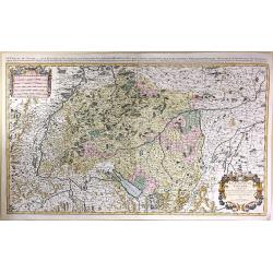
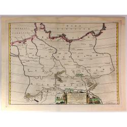
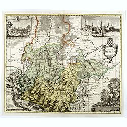
Le Cercle de Souabe Subdivise en Tous les Etats...
A fine, very large map of Swabenland including Lake Constance, Ulm, Augsburg, Basle, etc. Showing the sources of both the Danube and Rhine Rivers. This plate, after Sanso...
Date: Amsterdam, c1725
Selling price: ????
Please login to see price!
Sold in 2016
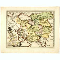
Persia cum adjaccentibus regionibus.
A very striking map of the ancient Persia and present-day Iran, Pakistan and Afghanistan, embellished with an colored pictorial title cartouche, putti and Roman coins.
Date: Nuremberg, 1725
Selling price: ????
Please login to see price!
Sold in 2016
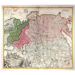
Generalis Totius Imperii Russorum Novissima Tabula.
Highly detailed map of the Russian Empire and northern China covering the region from Finland and the Black Sea to Kamchatka. It is from the beginning of the period when ...
Date: Nuremberg, 1725
Selling price: ????
Please login to see price!
Sold in 2016
Voyage des Enfants D'Israel dans le Desert Depuis Leur Sortie D'Egypte par la Mer Rouge
An interesting map illustrating the flight of the Children of Israel from Egypt to the Promised Land and their wandering in the desert in what is now Arabia. Mount Sinai ...
Date: Amsterdam, 1725
Selling price: ????
Please login to see price!
Sold in 2017
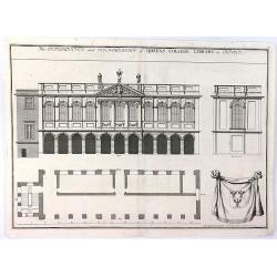
The Orthography and Ichnography of Queens College Library in Oxford
A striking antique original copper engraving printed ca. 1725. A splendid architectural view of The Queen's College Library in Oxford, with separate views of the East fa...
Date: London, c 1725
Selling price: ????
Please login to see price!
Sold in 2016
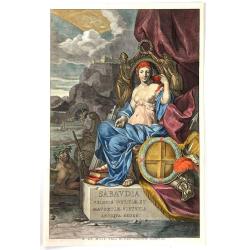
Sabaudia Velocis Iustitiæ et Mavortiæ Virtutis Antiqua Sedes
A striking decorative copper engraved title page from Valck & Schenk's “City Atlas of Piedmont, Italy”. The title page typifies the flourishing Dutch Renaissance ...
Date: Amsterdam, 1725
Selling price: ????
Please login to see price!
Sold in 2016
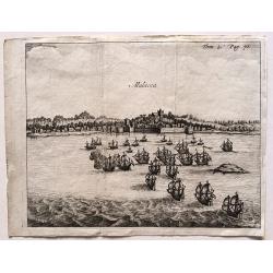
Malacca.
A fine print showing Dutch vessels offshore the city of Malacca. From the French reissue of the account of early Dutch voyages first published in 1608 by Commelin. The Fr...
Date: Amsterdam, 1725
Selling price: ????
Please login to see price!
Sold in 2016
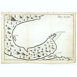
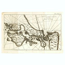
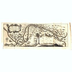
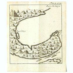
Baye la Baye.
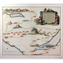
Early map of Albay Bay on the Southeast Coast of Luzon, with the northern tip of Samar in the lower right. The mountains rising in the upper left lead to Mayon Volcano.Fr...
Date: Amsterdam, F. Bernard, 1725
Selling price: ????
Please login to see price!
Sold in 2016
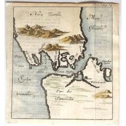
Nova Zemla.
Unusual, detailed, miniature map of Kara Strait and the southern tip of Novaya Zemlya, Russia, and the northern tip of Arctic Russia. The mountains are overstated. The ma...
Date: Paris, 1725
Selling price: ????
Please login to see price!
Sold in 2019
Ducatus Silesiae Iauranus. Aut : Frid : Kühnovio. . .
Rare Pieter Schenk edition of Friedrich Kubn's (Kühnovio) map of Jawor in southwest Poland based on Johann Gottfried Bartsch, map first published in Świdnica (then Schw...
Date: Amsterdam, 1700-1725
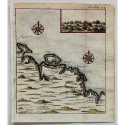
Cola (Untitled).
Uncommon map of part of the Kola peninsula coast, between the White and Barents Seas. It is in the Murmansk region.The town of Kola is shown but it is now eclipsed by the...
Date: Paris, 1725
Selling price: ????
Please login to see price!
Sold in 2017
Typus freti Manilensis. Détroit de Manilles.
This is a scarce map of Southern Luzon and the Manila Strait. Includes the Islands of Kalusunan, Mindoro, Burias, Ticao, and Isla han Samar. Includes fleets of ships and ...
Date: Rouen, Jean-Baptiste Machuel jr. 1725
Selling price: ????
Please login to see price!
Sold in 2017
Typus freti Magellanici quod . . .
Striking dark impression of De Renneville's edition of the Van Spilbergen map of the Straits of Magellan. The map includes a remarkable topographical treatment of the Str...
Date: Amsterdam, F. Bernard, 1725
Selling price: ????
Please login to see price!
Sold in 2017
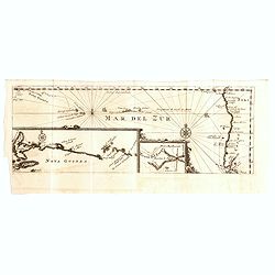
Mar del Zur / Nova Guinea / Terra del Fuogo.
Uncommon map depicting the west coast of South America (with inset map of Tierra del Fuogo) on the extreme right of the map, to Nova Guinea to the left. From the French r...
Date: Amsterdam, F. Bernard, 1725
Selling price: ????
Please login to see price!
Sold in 2018
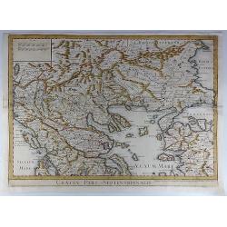
Graeciae Pars Septentrionalis.
A large and dramatic map by de L'Isle of the northern Greece, the Balkans, and Macedonia. Map extent covers from Dalmatia east to the Black Sea (Pontus Euxinus) and south...
Date: London, 1725
Selling price: ????
Please login to see price!
Sold in 2018
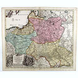
Regni Poloniae, ducatus Lithuaniae Voliniae, Podoliae Ucraniae Prussiae et Curlandiae Descriptio emendata per R. & I. Ottens.
Very rare map of Poland Lithuania and Ukraine, etc. Engraved by A. Schut.Joachim Ottens (1663 - 1719) and his sons Renier and Joshua were prominent Dutch booksellers and ...
Date: Amsterdam, 1725
Selling price: ????
Please login to see price!
Sold in 2017
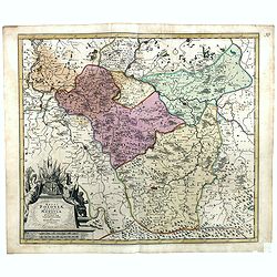
Regni Poloniae, ducatus Mazoviae et province Cujaviae / descriptio emendata per R. & I. Ottens
Very rare map of Poland Lithuania and Ukraine, etc. Engraved by A. Schut.Joachim Ottens (1663 - 1719) and his sons Renier and Joshua were prominent Dutch booksellers and ...
Date: Amsterdam, 1725
Selling price: ????
Please login to see price!
Sold in 2017
Descriptio Agri Batavi Aliorumque qui hodie cis Rhenum in dicione VII Foedereratorum Auctore Mensone Alting.
Unusual map of Zeeland and Flanders with ancient names. With good detail on rivers and islands. Decorated with numerous warriors engaged in battle.prepared by the Menso A...
Date: Amsterdam, 1725
Selling price: ????
Please login to see price!
Sold in 2018
Borussiae Regnum cum adjacentibus Regionibus. . .
Seutter's pocket map of northern Poland, Konigsburg (Kaliningrad) and of Lithuania. Includes the cities of Gdansk (Danzig), Elblag (Elbing), Malbork (Marienburg), Lidzbar...
Date: Augsburg, ca. 1725
Selling price: ????
Please login to see price!
Sold in 2018
Baye la Baye.
Early map of Albay Bay on the Southeast Coast of Luzon, with the northern tip of Samar in the lower right. The mountains rising in the upper left lead to Mayon Volcano.Fr...
Date: Amsterdam, F. Bernard, 1725
Selling price: ????
Please login to see price!
Sold in 2018
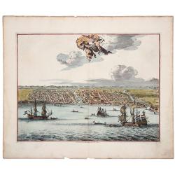
MACASAR, Capitale de Roiaume de meme nom.
A copperplate engraving that originates from the very scarce: 'La galerie agreable du monde. Tome premier des Indes Orientales.', published by P. van der Aa, Leyden, ca 1...
Date: Leiden, 1725
Selling price: ????
Please login to see price!
Sold in 2019