Browse Listings
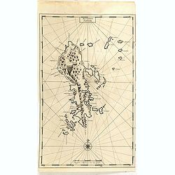
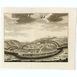
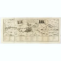
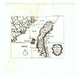
Het Eyland Saingir.
Map of the Sangi Island with relief shown pictorially. François Valentijn (1666-1727), a missionary, worked at Amboina from 1684 to 1694 and 1705 to 1713 and traveled ex...
Date: Amsterdam, 1726
Selling price: ????
Please login to see price!
Sold in 2020
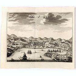
De Stad Manilhia.
A view of the city of Manila taken from the Bay. The view shows Intramuros, Cavite and churches then existing in the countryside around Manila at the beginning of the eig...
Date: Amsterdam, 1726
Selling price: ????
Please login to see price!
Sold in 2016
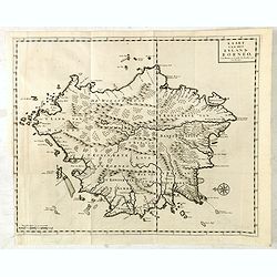
Kaart van het eyland Borneo.
Fine map depicting the Island of Borneo. North is orientated to the left of the page. Little interior detail is given but the coastlines, settlements and principal coasta...
Date: Amsterdam, 1726
Selling price: ????
Please login to see price!
Sold in 2015
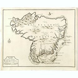
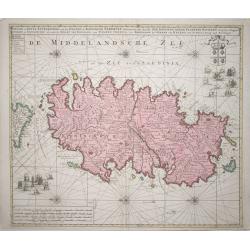
Kaart van het eyland Mauritius. . .
Fine map depicting the island of Mauritius. Little interior detail is given but the coastlines, settlements and principal coastal features are identified. An attractive e...
Date: Amsterdam, 1726
Selling price: ????
Please login to see price!
Sold in 2015
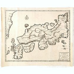
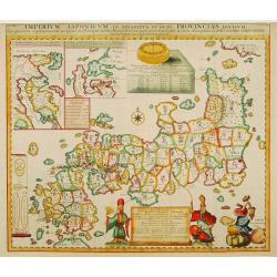
Nieuwe Kaart van het Eyland Japan verbeterd door Froncois Valentyn . . .
The map shows each of the Japanese provinces, with place names along the route from Nagasaki to Jedo and extends to show the eastern border of Korea. Only the mountain ra...
Date: Amsterdam, 1726
Selling price: ????
Please login to see price!
Sold in 2015
Kaart van het eyland Bali.
Fine map depicting the Island Bali, with part of the coasts of Java and Lomboc. Good interior detail is given with settlements, roads, etc. An attractive early map, one o...
Date: Amsterdam, 1726
Selling price: ????
Please login to see price!
Sold in 2016
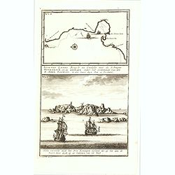
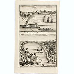
Het Eyland Amsterdam / Het Eyland St. Paulo / Swartte Swaane drift op het Eyland Rottenest.
The lower engraving showing two sailing ships and two long boats preparing to row up the Swan River, and the island discovered by the skipper de Vlamingh of the Dutch Eas...
Date: Amsterdam, 1726
Selling price: ????
Please login to see price!
Sold in 2015
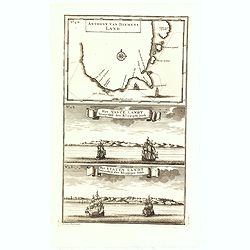
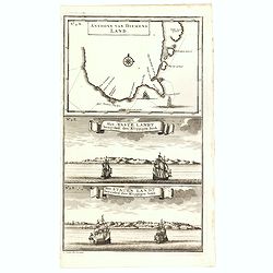
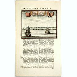
Anthony van Diemens Land / Het vaste Landt bezuyden den Klippigen hoek. / Het Staten Landt bezuyden den Klippigen hoek.
In the upper part, an early map of Tasmania (125x173mm.) shows the track of Abel Tasman's epic first voyage of 1642-1643, which resulted in the discovery of Tasmania and ...
Date: Amsterdam, 1726
Selling price: ????
Please login to see price!
Sold in 2015
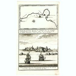
Staeten Landt Bezylt en Ontdekt met de Scheepen Heemskerk en de Zeehaen onder het Commande van den E. Abel Tasman. In den Iaare 1642. Den 13 December.
In the upper part an early map of Staten Landt (110x173mm.)One of the earliest separate depictions of Staten Landt published in François Valentyn's "Oud en nieuw Oo...
Date: Amsterdam, 1726
Selling price: ????
Please login to see price!
Sold in 2015
De Moordenaars Baay. Vertoont zich Aldus als gy daer in op 15 vadem ten anker legt. / Aldus vertoont zich Abel Tasmans Baay, als ghy 'er aldus in ten Anker legt op 33 Vadem.
In the lower part Abel Tasman's Bay (110x173mm.). Signed in plate, LL, 'F. Ottens. Fecit. Direxit.' insc".François Valentijn (1666-1727), a missionary, worked at Am...
Date: Amsterdam, 1726
Selling price: ????
Please login to see price!
Sold in 2015
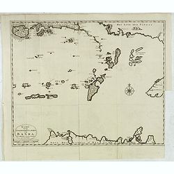
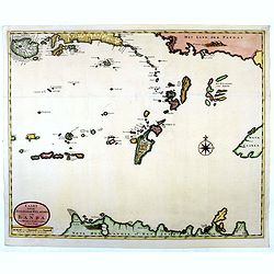
Kaart van de Zuyd-Ooster Eylanden van Banda.
Map of the Banda islands. In the lower part of the map early out lines of Australia showing the northern tip of Arnhem Land, the Arafura Sea, the south-west coast of !New...
Date: Amsterdam, 1726
Selling price: ????
Please login to see price!
Sold in 2015
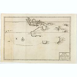
Kaart der Reyse van Abel Tasman volgens syn eygen opstel..
Rare and important map from Vol III, 2 of Valentyn’s Oud en Nieuw Oost Indien [1726] detailing the discoveries of Abel Tasman in Australasia during the course of his tw...
Date: Amsterdam, 1726
Selling price: ????
Please login to see price!
Sold in 2015
'T Eylant Amsterdam
Two engravings on one sheet showing the native boats and peoples of Amsterdam Island in the Banda Islands of Indonesia. Dutch (V.O.C.) sailing ships and various local cra...
Date: Amsterdam, 1726
Selling price: ????
Please login to see price!
Sold in 2019
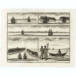
Aldus vertoond de kust van Nova Guinea . . .
Six engravings on one sheet showing coastal views of New Ireland. Dutch (V.O.C.) sailing ships in the foreground.François Valentijn (1666-1727), a missionary, worked at ...
Date: Amsterdam, 1726
Selling price: ????
Please login to see price!
Sold in 2019
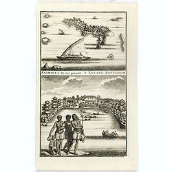
Anamocka by ons genaemt 'T Eylant Rotterdam.
Two engravings on one sheet showing the boats and peoples of Anamocka Island in the islands of Tonga.François Valentijn (1666-1727), a missionary, worked at Amboina from...
Date: Amsterdam, 1726
Selling price: ????
Please login to see price!
Sold in 2018
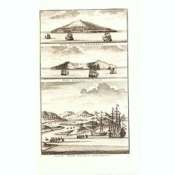
Volkeren van Nova Guinea , en hun Vaertuygen Het Brandende Eyland als het Noord West van u is De Kust van Nova Guinea beoosten het Eyland Jamma De Kust van Jamma nae Moa.
Four engravings on one sheet showing a native New Guinea boat with fishermen and coastal views of New Guinea with Dutch V.O.C. ships in the foreground.François Valentijn...
Date: Amsterdam, 1726
Selling price: ????
Please login to see price!
Sold in 2017
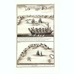
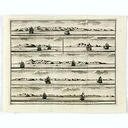
Aldus vertoonen zich de Eylanden Marken, . . .
Four engravings on one sheet showing panoramic views of the islands of Marken, the Groene islands, Sint Jans island and New Ireland, on the same latitude as Cabo de Santa...
Date: Amsterdam, 1726
Selling price: ????
Please login to see price!
Sold in 2016
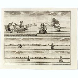
Het Eylandt Takel als gy, daar by Langhs Seylt . . .
Five engravings on one sheet showing the native boats and peoples and coastal views of islands near New Guinea. Dutch (V.O.C.) sailing ships and various local craft fill ...
Date: Amsterdam, 1726
Selling price: ????
Please login to see price!
Sold in 2018
Eauweck. Hoost Stad van Cambodia.
Map shows the jungle city in Cambodia.François Valentijn (1666-1727), a missionary, worked at Amboina from 1684 to 1694 and 1705 to 1713 and travelled extensively in the...
Date: Amsterdam, 1726
Selling price: ????
Please login to see price!
Sold in 2016
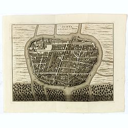
Judia, De Hoofd Stad van Siam.
A rare plan of map of Ayutthaya named "Judia, De Hoofd-Stad van Siam", copied after Johannes Vingboons.François Valentijn (1666-1727), a missionary, worked at ...
Date: Amsterdam, 1726
Selling price: ????
Please login to see price!
Sold in 2016
De Groote Siamse Rievier Me-Nam ofte Moeder der Wateren inharen loop met de in vallende Spruyten Verbeeld. . .
Rare map centred on Ayutthaya which town was situated eighty kilometres inland from the mouth of the Gulf of Thailand at the juncture of three rivers. Access required man...
Date: Amsterdam, 1726
Selling price: ????
Please login to see price!
Sold in 2016
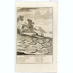
Siamsche Rochevellen.
Engraving of drying sting ray skins on the beach, with below a lettered key A-M.François Valentijn (1666-1727), a missionary, worked at Amboina from 1684 to 1694 and 170...
Date: Amsterdam, 1726
Selling price: ????
Please login to see price!
Sold in 2017
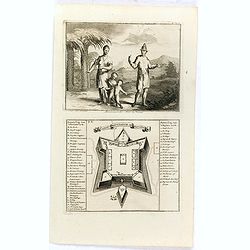
Macassaarsche Man en Vrouw / 't Casteel Rotterdam op Maccasar.
Two engravings on one sheet showing a man and woman from Macassar and a plan of the Rotterdam Fort in Macassar (now Ujung Pandang) on the island of Sulawesi.François Val...
Date: Amsterdam, 1726
Selling price: ????
Please login to see price!
Sold in 2016
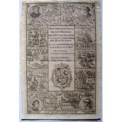
(Title page) Historia General De Los Hechos De Los Castellanos En Las Islas Y Tierra Firma Del Mar Oceano.
A rare engraved pictorial title page to Volume 2 of the "General History of the Deeds of the Castillians on the Islands and Mainland of the Ocean Sea", the famo...
Date: Madrid, 1726
Selling price: ????
Please login to see price!
Sold in 2016
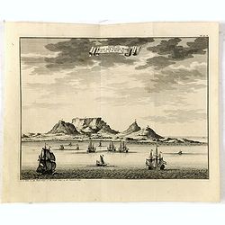
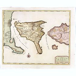
Gezicht van Kaap Der Goede Hope als men op de Reede legt.
Decorative panoramic view of the town of Samboupo on the island of Celebes (Sulawesi) in today's Indonesia. Dutch (V.O.C.) sailing ships and various local craft fill the ...
Date: Amsterdam, 1726
Selling price: ????
Please login to see price!
Sold in 2017
Anthony van Diemens Land / Het vaste Landt bezuyden den Klippigen hoek. / Het Staten Landt bezuyden den Klippigen hoek.
In the upper part, an early map of Tasmania (125x173mm.) shows the track of Abel Tasman's epic first voyage of 1642-1643, which resulted in the discovery of Tasmania and ...
Date: Amsterdam, 1726
Selling price: ????
Please login to see price!
Sold in 2016
Staeten Landt Bezylt en Ontdekt met de Scheepen Heemskerk en de Zeehaen onder het Commande van den E. Abel Tasman. In den Iaare 1642. Den 13 December.
In the upper part an early map of Staten Landt depicting Tasman's voyage down the west coast of New Zealand in his ships Heemskerk and Zeehaen. The coast line in the Cook...
Date: Amsterdam, 1726
Selling price: ????
Please login to see price!
Sold in 2016
Kaart van de Zuyd-Ooster Eylanden van Banda.
Map of the Banda islands. In the lower part of the map early out lines of Australia with van Diemens Land.François Valentijn (1666-1727), a missionary, worked at Amboina...
Date: Amsterdam, 1726
Selling price: ????
Please login to see price!
Sold in 2018
Anthony van DiemensLand. Vertoont hem aldus als gy uyt den westen komt, en zyt op de Zuyder breete van 42 1/2 graad.
One of the earliest depictions of the coast line of Tasmania. Two Dutch vessels off shore. With Dutch letter press on both side giving a description of Tasmania and "...
Date: Amsterdam, 1726
Selling price: ????
Please login to see price!
Sold in 2017
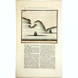
Beschryvinge van ... (N°.2.B) 1. Boreels Eylanden . 2 Storm bay. 3. Zuyd Caep. 4.Tasmans Eyland.
One of the earliest maps of Tasmania. Two Dutch vessels off shore. With a numbered key : 1. Boreels Eylanden . 2 Storm bay. 3. Zuyd Caep. 4.Tasmans Eyland.With Dutch lett...
Date: Amsterdam, 1726
Selling price: ????
Please login to see price!
Sold in 2017
Die Insel Formosa neu abgemessen auf Befehl Kaysers Kamhi.
One of the earliest, if not the earliest, obtainable printed map of Taiwan or Formosa Island. It was issued around 1726 to illustrate Joseph Stöcklein's compellation of ...
Date: Augsburg, 1726
Selling price: ????
Please login to see price!
Sold in 2018
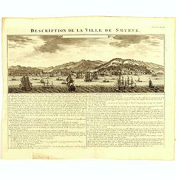
Description de la Ville de Smyrne.
This elegant view presents the Turkish city of Izmir from a vantage in the Gulf of Izmir. The city is shown in excellent detail before a mountainous backdrop, while numer...
Date: Amsterdam, 1726
Selling price: ????
Please login to see price!
Sold in 2021
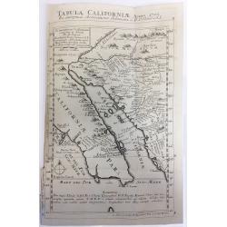
Tabula Californiae Anno 1702 ex Autoptica Observatione Delineata a R.P. Chino e S.I.
Map of California based on Kino's map, originally drawn in 1702. Kino's map carefully records the results of nine journeys he made in northwestern Mexico and along the Co...
Date: Augsburg, 1726
Selling price: ????
Please login to see price!
Sold in 2019
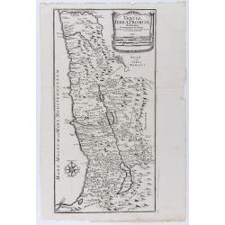
Tabula terrae promissionis ab Auctore Commentarii in Josue et a Liebaux Geographo Incisa.
Uncommon map of the Holy Land, based upon the commentary of Joshua. Division of the territory into 12 tribes. Wind rose in lower left. An unusual Italian version of Augus...
Date: Venice, 1726
Selling price: ????
Please login to see price!
Sold in 2020
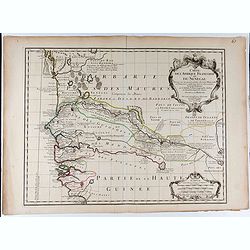
Carte de l'Afrique Françoise ou du Senegal.
De L'Isle's highly detailed map of part of the West Coast of Africa, from Cap Blanc to the Pays des Mallus, centered on the Gambia River and Senegal River. Good detail al...
Date: Paris, 1726
Selling price: ????
Please login to see price!
Sold in 2020
![Tabula Californiae, Anno 1702 … Ex autoptica observatione delineata a R.P. Chino e S.I. [The Map of California in 1702 as Observed and Drawn by Father Chino, S. J.]](/uploads/cache/85891-250x250.jpg)
Tabula Californiae, Anno 1702 … Ex autoptica observatione delineata a R.P. Chino e S.I. [The Map of California in 1702 as Observed and Drawn by Father Chino, S. J.]
The much sought after so-called KINO-map of California as a peninsula, a result of Father Kino's travels which misspelled the island-phantasy. This his second map is...
Date: Augsburg & Graetz, 1726
Selling price: ????
Please login to see price!
Sold in 2021
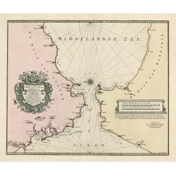
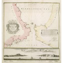
Nieuwe Paskaart vant Naauw van de Straat. op gedragen aan den Hoog Edel geboren Heer F. Van Aerssen Van Sommelsduk
This is a scarce and well designed sea chart of the Strait of Gibraltar, oriented east with Spain on the left and the Barbary Coast (present-day Morocco) on the right. Th...
Date: Amsterdam 1726
Selling price: ????
Please login to see price!
Sold in 2023
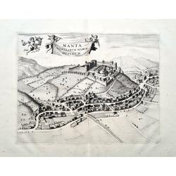
Manta Salutiarum March Oppidum
Beautifully engraved view of Manta in Piemonte. Shows the town with detailed buildings, roads, and fields. The title banner and the coat of arms are held by putti. From ...
Date: Amsterdam, 1726
Selling price: ????
Please login to see price!
Sold in 2023
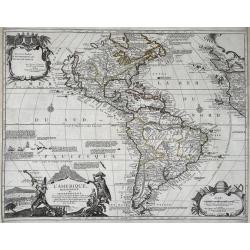
L'Amerique, Meridionale, et Septentrionale.
An uncommon map of the Americas. Full title in a decorative cartouche at bottom left: 'L'Amerique, Meridionale, et Septentrionale Dressee selon les Dernieres Relations et...
Date: Paris, 1727
Selling price: ????
Please login to see price!
Sold in 2021
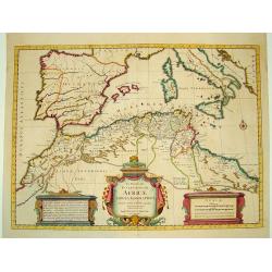
In Notitiam Ecclesiasticam Africae...
A finely engraved map of the northern coast of Africa and western Mediterranean sea, including southern Europe. The African portion of the work offers exceptional detail,...
Date: Amsterdam, ca. 1727
Selling price: ????
Please login to see price!
Sold
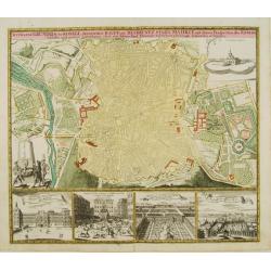
Accurater grundris der .. Spanischen Haupt und Residentz stadt MADRIT ..
This plan of Madrid is richly ornated by various garden scenes, as well below with four views, among them we find the Royal Residence, Aranjuez and the Place Major.
Date: Nuremberg 1727
Selling price: ????
Please login to see price!
Sold
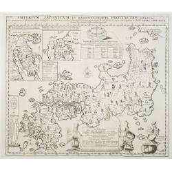
Imperium Japonicum in sexaginta et octo provincias..
The most important influence on European maps of Japan during the early years of the eighteenth century was that of E. Kaempfer based upon the manuscripts compiled during...
Date: The Hague 1727
Selling price: ????
Please login to see price!
Sold
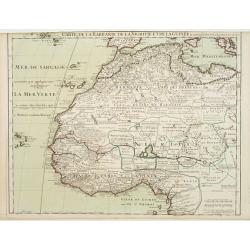
Carte de La Barbarie de La Nigritie et de Guinee.
A detailed engraved map of north west Africa including the Canary and Cape Verde Islands. The title is displayed along the top of the map. A rare re-issue of De l'Isles m...
Date: Amsterdam, 1727
Selling price: ????
Please login to see price!
Sold in 2012
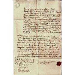
Loan Document
English loan document from 1727 with seal and eight pence stamp
Date: England 1727
Selling price: ????
Please login to see price!
Sold in 2008
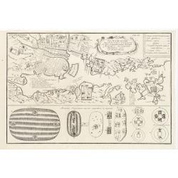
Urbs Nangasaki Cum Portu & Agro circumjacenti..
Showing Nagasaki harbour. From The History of Japan, Scheuchzer's translation of Kaempfer's Imperium Japonicum.
Date: London 1727
Selling price: ????
Please login to see price!
Sold

Academia Tertia Anglicana or The Antiquarian Annals of Stanford in Lincoln, Rutland, and Northampton Shires
First Edition of Peck's history of Stanford. Describing University, churches, schools of Stanford and several other places. Folding panorama frontis 'The Prospect of the ...
Date: 1727
Selling price: ????
Please login to see price!
Sold in 2010
Nieuwe Paskaart van t Naauw van de Straat. . . F.van Aerssen van Sommelsdyk, de plaat bommel en Spyk. . . Hendrik Lynslager. . . 1726.
Chart of the entrance of the Mediterranean overlooking the Strait of Gibraltar. Based on the charts by Hendrik Lynslager, a Dutch navigator, this interesting sea chart de...
Date: Amsterdam, ca. 1727
Selling price: ????
Please login to see price!
Sold in 2013
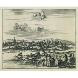
Cassimogorod ville de la Tartarie Moscovite.
Decorative view of the town of Cassimogorod, a Russian city near the northern shore of the Caspian sea as seen from across the river Occa. Finely etched view after a draw...
Date: Leiden, 1727
Selling price: ????
Please login to see price!
Sold in 2010
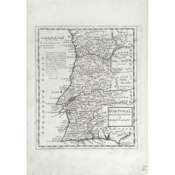
Portugal. Agreeable to Modern History. . .
Detailed, small scale map of Portugal by Herman Moll (fl.1680-1732). Little is known of Herman Moll's early life, but he emigrated from what is now northern Germany and s...
Date: London, 1727
Selling price: ????
Please login to see price!
Sold in 2010
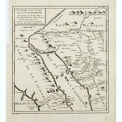
Passage par Terre a la Californie ..
Father Kino's important map was the first map to accurately depict the region, in particular the relative positions of the Colorado and Gila rivers and the correct locali...
Date: Paris, 1727
Selling price: ????
Please login to see price!
Sold in 2011
Imperium Japonicum in sexaginta et octo provincias divisum. Ex ipsorum Japonensium mappis & observationibus Kaempferianis. . .
The most important influence on European maps of Japan during the early years of the eighteenth century was that of E. Kaempfer based upon the manuscripts compiled during...
Date: The Hague, 1727
Selling price: ????
Please login to see price!
Sold in 2022
Château Kremelin, dans la ville de Moscou, avec la celebration de la Fete de Pâques Fleuries.
Decorative view of the Kremlin in Moscow, showing the Palm Sunday festivities at the Kremlin. Some buildings with captures: Kremlin, Porte du Sauveur. S. Nicolai. This we...
Date: Leiden, 1719-1727
Selling price: ????
Please login to see price!
Sold in 2013
Astrakan, ville capitale du royaume du même nom en Moscovie.
Decorative view of the town of Astrakan. This well executed engraving was published in 1729 and 1727 by Pieter van der AA, in Leiden in "Voyages tres-curieux et tres...
Date: Leiden, 1719-1727
Selling price: ????
Please login to see price!
Sold in 2014
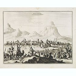
Soltanie Ville de la Perse en Arabie.
Decorative view of the town of Soltanie with on the foreground camels and horses. This well executed engraving was published in 1729 and 1727 by Pieter van der AA, in Lei...
Date: Leiden, 1719-1727
Selling price: ????
Please login to see price!
Sold in 2015
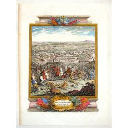
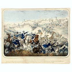
The Battle of Piterwaradin - August the V, 1716.
Antique hand-colored folio copper plate from Jean Dumont's book "The Military History of the Late Prince Eugene of Savoy and the Late John Duke of Marlborough"....
Date: London, 1727
Selling price: ????
Please login to see price!
Sold in 2015

Ceremonie Nuptiale du Japon / Ceremonie Funebre du Japon.
Two fine copper engravings, on a large folio sheet. The highly detailed views show wedding and funeral ceremonies of Japan.Published in "Cérémonies et Coutumes rel...
Date: Paris, 1727
Selling price: ????
Please login to see price!
Sold in 2018
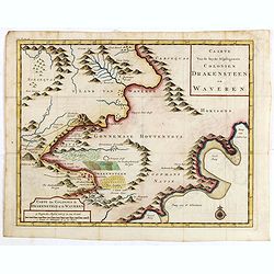
Caarte van de beyde afgelegenste colonien Drakensteen en Waveren...
Fine and early map of Colonies of Drakenstein in South Africa, from Kolbe's "Naukeurige en Uitvoerige beschryving van de Kaap de Goede Hoop".
Date: Amsterdam, 1727
Selling price: ????
Please login to see price!
Sold in 2015
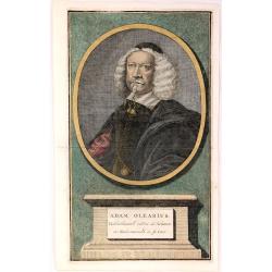
Adam Olearius , Bibliothecaire du Duc de Holstein.
Adam Olearius (1599–1671), was a German scholar, mathematician, geographer and librarian. He became secretary to the ambassador sent by Frederick III, Duke of Holstein-...
Date: Germany, 1727
Selling price: ????
Please login to see price!
Sold in 2017
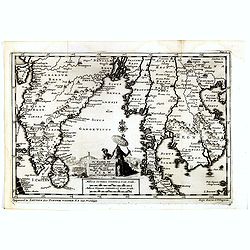
De Kusten van Guzaratte, Malabaar, Bengale en Malacca met die van't Magtig Koninkryk Siam totaan China bestevend.
A fine detailed map centered on India, also including the Malaysian pen insular. With charming pictorial title piece lower center, with a man and his servant, a temple an...
Date: Leiden, 1727
Selling price: ????
Please login to see price!
Sold in 2017
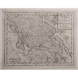
A Map of Epirus, Thessaly and Achaia.
Detailed map of Epirus, Thessaly and Achaia and Peloponnesus in Greece. Cartographer unknown.
Date: ca. 1727
Selling price: ????
Please login to see price!
Sold in 2020
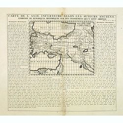
Carte De L'Asie Inferieure Selon Les Auteurs Anciens, Enrichie de Remarques Historiques sur les Changemens qui y sont arrivez (shows Cyprus)
Text page with inset map (220x269.mm.) of Turkey, including Cyprus. From Chatelain's Atlas Historique, 1732-1739. In upper right margin: 'Tom. V. No 3. Pag: 16.'
Date: Amsterdam, 1728
Selling price: ????
Please login to see price!
Sold in 2012
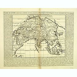
Carte de l'Asie selon les auteurs anciens enrichie de remarques historiques. . .
The map (290x365mm.) is centered on the India and the Indian Ocean, with explanatory text on either side of the map. From Chatelain's Atlas Historique, 1732-1739. In uppe...
Date: Amsterdam, 1728
Selling price: ????
Please login to see price!
Sold in 2012
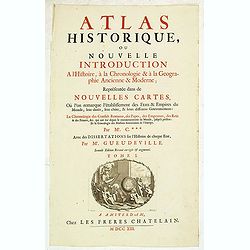
(Title page) Atlas historique, ou nouvelle introduction. . .
From Chatelain's "Atlas Historique". Tittle page in French, with in lower part a copper engraving 99x128mm. By J. Goeree showing putti, globes, maps and the fig...
Date: Amsterdam, 1728
Selling price: ????
Please login to see price!
Sold in 2012
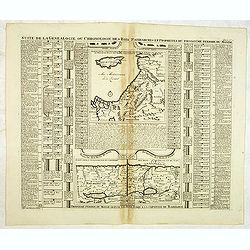
Suite de la généalogie ou chronologie des rois patriarches. . .
Page with two historical maps. One showing Israel and Judæa with a part of Syria, "Arabie Heureuse", and Egypt; the other one showing the region occupied by Is...
Date: Amsterdam, 1728
Selling price: ????
Please login to see price!
Sold in 2013
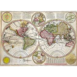
De Werelt Caart.
Published in a Dutch Bible with Biblical text on verso. A beautifully engraved double hemisphere map derived from up-to-date sources of information (probably French). The...
Date: Amsterdam, 1728
Selling price: ????
Please login to see price!
Sold in 2013
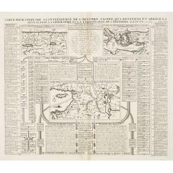
Carte pour conduire à l'intelligence de l'histoire sacrée qui renferme en abrégé la généalogie, la géographie et la chronologie de l'Histoire Sainte. Seconde période du Monde depuis Moyse jusqu'au règne des Rois d'Israël et de Juda.
A Map Showing the understanding of Sacred History, containing an abbreviated genealogy, geography and chronological history of the Bible.Henri Abraham Chatelain (1684 –...
Date: Amsterdam, 1728
Selling price: ????
Please login to see price!
Sold in 2013
Representation Et Description Du Soulevement Des IV. Princes Du Mogol Contre L'Empereur Leur Père du Combat dans lequel Aureng-Zeb demeura vainqueur dese trois Freres & c. sit ensuite proclamer Empereur.
Fascinating engraving depicting a grand battle between the princes of the Mughal Empire. Aurangzeb was the last of the great Mughal emperors and the empire reached its la...
Date: Amsterdam, 1728
Selling price: ????
Please login to see price!
Sold in 2013
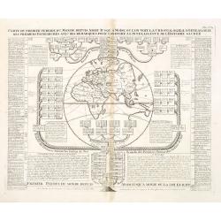
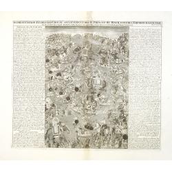
Carte du premier periode du Monde depuis Adam jusque' a Moise ou l'on voit la Chronologie & la genealogie des premeirs patriarches avec des remarques pour conduire a l' intelligence de l' Histoire sacree.
Fascinating engraving depicting a map of the Old World surrounded and keyed to a Biblical genealogical family tree. Panels at the side provide a historical timeline for t...
Date: Amsterdam, 1728
Selling price: ????
Please login to see price!
Sold in 2013
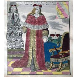
Icon Synoptica Sac. Rom. Imp. Electorum, Ducum, Principum.
Famous plate of an Elector in full robes, covered with listings of all the rulers of the Holy Roman Empire, princes, electors, and dukes. At the left is a pillar with her...
Date: Augsburg, 1728
Selling price: ????
Please login to see price!
Sold in 2013
Nieuwe en Nette Aftekening van het Eyland of Koningkrijk Sardinia..
Fine, large map of Sardinia made by Gerard van Keulen.
Date: Amsterdam, 1728
Selling price: ????
Please login to see price!
Sold in 2013
A Chart of the Sound -- A Map of the rivers Elbe and Weser -- The River Dvina and the harbour of Archangel.
Scarce sea chart by John Harris (1667?-1719) and James Knapton (d. 1738). Chart 20 from "Atlas maritimus & commercialis", showing Lapland and part of the Ru...
Date: London, J. Knapton, 1728
Selling price: ????
Please login to see price!
Sold in 2013
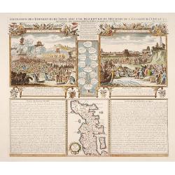
Succession des Empéreurs du Japon. . .
A fine folio sheet of engravings depicting the death of the Emperor Cubo and the arrival of one of the early Dutch embassies to Japan and a small map of the main island H...
Date: Amsterdam, 1728
Selling price: ????
Please login to see price!
Sold in 2014
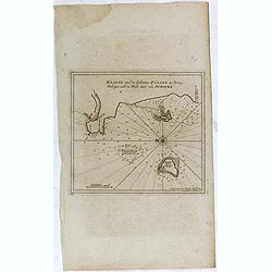
Van Keulen Map of the Pisang Islands on the West Coast of Sumatra.
Very rare chart of Pisang Island, a small island near Padang, on the west coast of Sumatra, Indonesia. Oriented to the west, this map covers the coast of Padang, and the ...
Date: Amsterdam, 1728
Selling price: ????
Please login to see price!
Sold in 2015
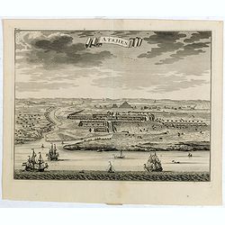
Atsjien.
From Francois Valentyn's "Oud en Nieuw Oost Indien, part V : Beschryving van Coromandel, Pegu, Arrakan, Bengale, Mocha, Persien, Malakka, Sumatra, Ceylon."A bir...
Date: Amsterdam, 1728
Selling price: ????
Please login to see price!
Sold in 2015
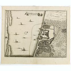
laffenapatnam.
From Francois Valentyn's "Oud en Nieuw Oost Indien, part V : Beschryving van Coromandel, Pegu, Arrakan, Bengale, Mocha, Persien, Malakka, Sumatra, Ceylon."A bir...
Date: Amsterdam, 1728
Selling price: ????
Please login to see price!
Sold in 2015
Punto de Galle.
From Francois Valentyn's "Oud en Nieuw Oost Indien', part V : Beschryving van Coromandel, Pegu, Arrakan, Bengale, Mocha, Persien, Malakka.. Sumatra, Ceylon."An ...
Date: Amsterdam, 1728
Selling price: ????
Please login to see price!
Sold in 2017
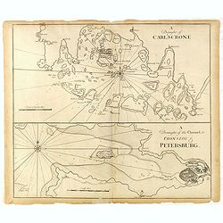
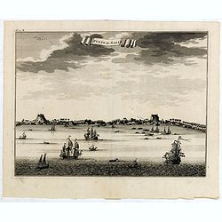
A Draught of Carlscone. A Draught of the Channel to Cronslot & Petersburg.
Two charts on one sheet: the upper chart is Karlskrona in Sweden, built as a base for the Royal Swedish Navy.The lower chart shows the approaches to St Petersburg, with K...
Date: London: J. & J. Knapton, W. & J. Innys, 1728
Selling price: ????
Please login to see price!
Sold in 2015
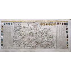
Carte Generale des Etats du Czar Empereur De Moscovie
A large and dramatic depiction of the Czars and their vast territories from 15th century to the early 18th century. Twenty-eight armorial shields, all color coded, are se...
Date: Amsterdam, ca 1728
Selling price: ????
Please login to see price!
Sold in 2015
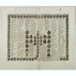
Carte genealogique des Rois de France avec l'Etat des Principaux Officiers de la Maison du roy.
A genealogical tree of the French kings with descriptive French text, from Chatelain's monumental 7 volume "Atlas Historique". Henri Abraham Chatelain (1684 –...
Date: Amsterdam, 1728
Selling price: ????
Please login to see price!
Sold in 2016
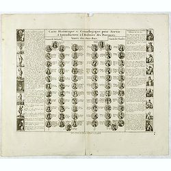
Carte Historique & Cronologique pour Servir d'Introduction a l'Histoire des Provinces Unies des Pays-Bas.
This folio sheet shows a genealogical chart and portraits of the rulers of Holland and Flanders with descriptive French text, from Chatelain's monumental 7 volume "A...
Date: Amsterdam, 1728
Selling price: ????
Please login to see price!
Sold in 2016