Browse Listings
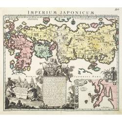
Imperium Japonicum.
The map is based on Englebert Kaempfer's map of 1727. It shows a much distorted outline for the Island of Japan and a wonderful decorative cartouche top left.The map was ...
Date: Augsburg 1720
Selling price: ????
Please login to see price!
Sold in 2011
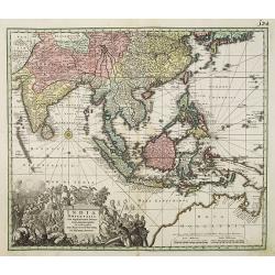
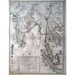
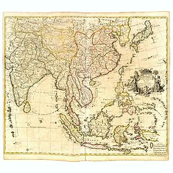
India Orientalis cum adjacentibus. . .
The finely engraved detail shows the whole of the region from India to the Dutch discoveries in the Gulf of Carpentaria in northern Australia. The map is embellished by a...
Date: Augsburg, 1720
Selling price: ????
Please login to see price!
Sold in 2010
![De bubbel jonge op de jagt. [The hunting bubble boy.]](/uploads/cache/28091-250x250.jpg)
De bubbel jonge op de jagt. [The hunting bubble boy.]
Print published in : Het groote tafereel der dwaasheid : vertoonende de opkomst, voortgang en ondergang der actie, bubbel en windnegotie, in Vrankryk, Engeland, en de Ned...
Date: Amsterdam, 1720
Selling price: ????
Please login to see price!
Sold
De wintgot, uytgebuldert hebbende, laat niet dan rampen na.
Print published in : Het groote tafereel der dwaasheid : vertoonende de opkomst, voortgang en ondergang der actie, bubbel en windnegotie, in Vrankryk, Engeland, en de Ned...
Date: Amsterdam, 1720
Selling price: ????
Please login to see price!
Sold
Tytel-print der actie-kraam of voor-hof van Quinquenpoix.
Print published in : Het groote tafereel der dwaasheid : vertoonende de opkomst, voortgang en ondergang der actie, bubbel en windnegotie, in Vrankryk, Engeland, en de Ned...
Date: Amsterdam, 1720
Selling price: ????
Please login to see price!
Sold in 2010
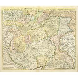
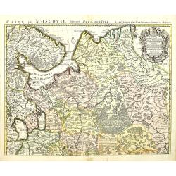
Partie méridionale de Moscovie.
Centered on Moscow including Azow in the bottom part of the map.The Amsterdam publishing firm of Covens and Mortier (1721 - c. 1862) was the successor to the extensive pu...
Date: Amsterdam, ca. 1720
Selling price: ????
Please login to see price!
Sold in 2012
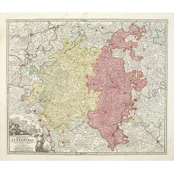
Ducatus Luxemburgi . . .
Fine map of Luxembourg by J. B. Homann. With one decorative cartouche in lower left corner.
Date: Nuremberg, ca. 1720
Selling price: ????
Please login to see price!
Sold in 2011
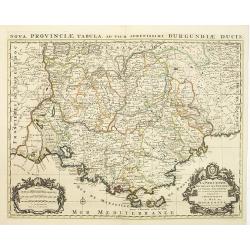
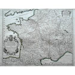
La Provence divisée en ses vigueries et terres adjacentes. . .
Detailed map of southern France. Showing the cities of Marseille, St.Tropez, Cannes, Nice, Antibes, Aix, Orange, Barcelonette, Senez., and Monaco, etc.Prepared by one of ...
Date: Amsterdam, ca 1720
Selling price: ????
Please login to see price!
Sold in 2010
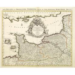
Le Duché et Gouvernement de Normandie divisée en Haute et Basse Normandie.
An attractive large-scale map depicting Normandy. Embellished with a large title-cartouche. Prepared by one of the greatest French mapmakers Hubert Jaillot, and republish...
Date: Amsterdam, ca. 1720
Selling price: ????
Please login to see price!
Sold in 2010
Magni Ducatus Lithuaniae.
An attractive large-scale map depicting Lithuania, embellished with a large title-cartouche with coat of arms. Published in Amsterdam by Renier and Joshua Ottens. Joachim...
Date: Amsterdam, ca. 1720
Selling price: ????
Please login to see price!
Sold in 2010
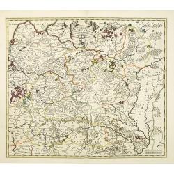
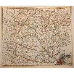
L\'empire d\'Allemagne divisé en tous ses états.
An attractive large-scale map depicting Germany, Poland, the Netherlands, Belgium, Luxemburg, Switzerland and Austria, embellished with a large title-cartouche with coat ...
Date: Amsterdam, ca. 1720
Selling price: ????
Please login to see price!
Sold in 2011
Carte de Moscovie dressée par G.De L\'Isle.
Centered on Moscow, including Lapland. With fine uncolored title cartouche.The Amsterdam publishing firm of Covens and Mortier (1721 – c. 1862) was the successor to the...
Date: Amsterdam, 1720
Selling price: ????
Please login to see price!
Sold in 2012
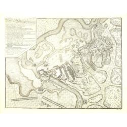
Plan van de Slag gelevert tuschen het Leger van zyne Keyz. . . pris Eugenius van Savoyen. . tusschen Petervaradin en Carlowitz. . .
Uncommon engraving showing the Battle of Petrovaradin or Battle of Peterwardein, which was a decisive victory for Austrian forces in the war between Austria and the Ottom...
Date: Amsterdam, ca. 1720
Selling price: ????
Please login to see price!
Sold in 2011
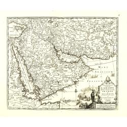
Description exacte de l'arabie heureuse, Petrée et Déserte.
Very rare map of Arabian peninsular, here called "L'Arabie heureuse", "Arabia Felix" or "Happy Arabia", prepared by Pierre van der AA (1659-...
Date: Amsterdam, ca 1720
Selling price: ????
Please login to see price!
Sold in 2010
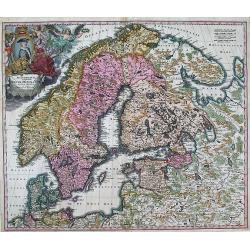
SCANDINAVIA complectens SUECIAE, DANIAE, & NORVEGIAE, REGNA. ex Tabula Joh. Baptista Homann.
A large, detailed map showing all of Scandinavia, including the Baltic region and parts of Russia. An attractive title cartouche decorates the upper left corner of the ma...
Date: Nurnberg, c.1720
Selling price: ????
Please login to see price!
Sold in 2013
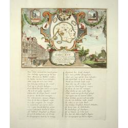
Afbeeldinge van 't zeer vermaarde Eiland Geks-Kop
These satirical engravings are some of the most famous cartographic curiosities. They represent the collapse of the French Compagnie de la Louisiane d'Occident, and simil...
Date: 1720
Selling price: ????
Please login to see price!
Sold in 2011
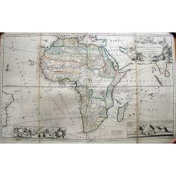
To the Right Honourable Charles, Earl of Peterborow, and Monmouth, &c. This Map of Africa
Herman's Moll's magnificently detailed large scale map of Africa, one of the finest and probably most decorative depictions of the continent made in the eighteenth-centur...
Date: London, c1720
Selling price: ????
Please login to see price!
Sold in 2011
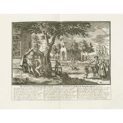
De verreeze Frederik Hendrik ouwerwets patroon der verkeerde barmhertigheid. . .
The title translates into English as following : "Frederick Henry arisen, the ancient patron of ill-placed commiseration, etc".Underneath the print text in Dutc...
Date: Amsterdam, 1720
Selling price: ????
Please login to see price!
Sold
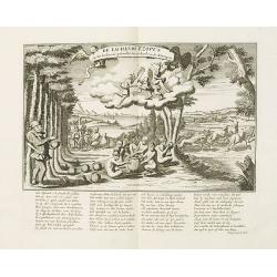
De lachende Ezopus op het koolmaal..
The title translates into English as following : "The laughing Aesop, present at the cole, or cabbage-feast, which was given at the leave-taking of the stock-apes.&q...
Date: Amsterdam, 1720
Selling price: ????
Please login to see price!
Sold
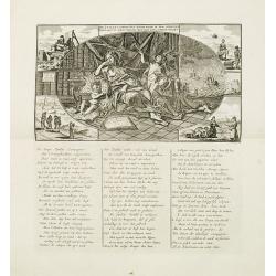
De Zuid Zé Compagnie door wind in top gerezen beklaagt nu haar verlies met een bekommerd wezen.
Decorative print with Dutch title and verso, the title translates as follows: "The South Sea Company, having risen to the top by wind, now laments her loss with a ru...
Date: Amsterdam, 1720
Selling price: ????
Please login to see price!
Sold
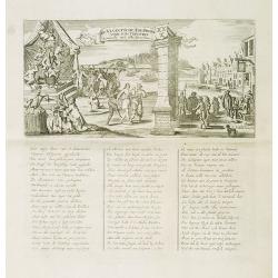
De Viaantsche tol-poort voor d'actionisten komende uyt alle steeden.
The title translates in English as follows : "The tollgate of Vianen for the shareholders arriving from all towns". Decorative !A caricature in prose and verse ...
Date: Amsterdam, 1720
Selling price: ????
Please login to see price!
Sold
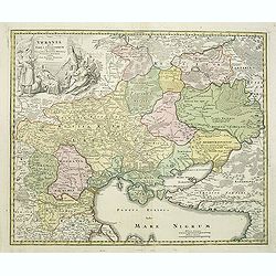
Ukrania quae et Terra Cosaccorum..
Homann's map is based upon Beauplan's general map of Ukraine but depicts the political changes of the preceding years. The cartouche portrays Hetman Mazepa with his follo...
Date: Nuremberg, 1720
Selling price: ????
Please login to see price!
Sold in 2011
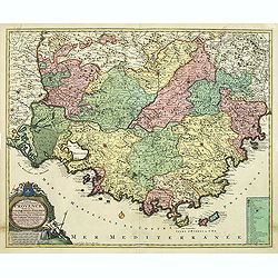
Comte de gouvernement général de Provence divisé en ses sénéchaussees et vigurie. . .
Map of Provence prepared by Frederik de Wit. The copper plate was acquired by Pierre Mortier. The Amsterdam publishing firm of Covens and Mortier (1721 - c. 1862) was the...
Date: Amsterdam, 1720
Selling price: ????
Please login to see price!
Sold in 2014
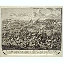
Vue et représentation de la bataille de Hochstedt donnée le 13 d\'aoust 1704. . .
Extremely fine and detailed engraving by Huchtenburg depicting the siege of Hochstedt (Germany) by Price Eugene on August 13th 1704.From Jean Dumont's, "Batailles ga...
Date: The Hague, Pierre Husson, 1720
Selling price: ????
Please login to see price!
Sold in 2011
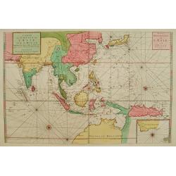
Carte des Costes de L'Asie sur L'Ocean Contenant les Bancs Isles et Costes &c . . . Partie Orientale de L'Asie sur L'Ocean .
Pristine nautical with an inset of southern coast of southern Australia and Tasmania in the wake of Tasman and other 17th century Dutch explorations of these regions: di...
Date: Amsterdam, 1720
Selling price: ????
Please login to see price!
Sold in 2015
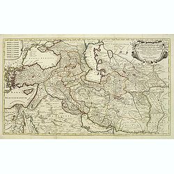
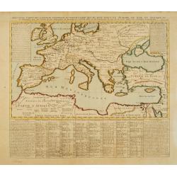
Regnum Persicum Imperium Turcicum in In Asia Russorum Provinciae ad Mare Caspium. . .
Striking and rare map of the region bounded by Cyprus and the Eastern Mediterranean, the Nile, Medina, the Persian Gulf and the Indus River in the south and the Black Sea...
Date: Amsterdam, 1720
Selling price: ????
Please login to see price!
Sold in 2011
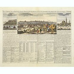
Etat abregé de la Maison du Grand Seigneur. . . Vue de Constantinople. . .
This impressive engraving is a wonderful example of Chatelain’s elegant plates. Ornamented with 3 vignettes: Vuë du Serrail de Constantinople, Vuë de Constantinople, ...
Date: Amsterdam, ca. 1720
Selling price: ????
Please login to see price!
Sold in 2011
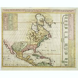
Nouvelle Carte de l\' Amerique Septentrionale Dressee sur les plus Nouvelles Observations de Messieurs de l\' Academie. . .
Great map of North America with well developed cartography in the Great Lakes and Mississippi River.It includes all of Central America and the West Indies. The English se...
Date: Amsterdam, 1720
Selling price: ????
Please login to see price!
Sold in 2011
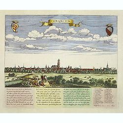
Ultrajectum (Utrecht)
A rare panoramic of Utrecht first published by Dancker Danckerts, here with a changed address. With a numbered key (1-23) to principal places in town and a poem in Latin...
Date: Amsterdam, (1660) c.1720
Selling price: ????
Please login to see price!
Sold in 2013
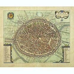
Bruge een der voornaamste steden van Vlaandren.
Detailed plan of Bruges from Flandria Illustrata . In lower right corner "Tom. II. No.37." and title now in Dutch and French, but not with the imprint of Covens...
Date: Amsterdam, 1720
Selling price: ????
Please login to see price!
Sold in 2011
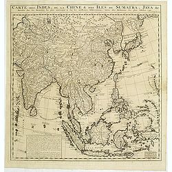
Carte des Indes, de la Chine & des Isles de Sumatra, Java &c..
This fine and quite detailed general map extends from northern Japan to Timor and from India to New Guinea.From the important Atlas Historique et Méthodique.Here, the Te...
Date: Amsterdam, 1720
Selling price: ????
Please login to see price!
Sold in 2011
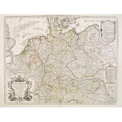
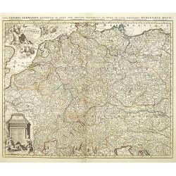
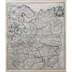
L'Allemagne dressee sur les observations de Tycho-Brahe de Kepler de Selnius. . .
Engraved map in outline color by one of France most important mapmakers. Covers the Low Countries, Germany, Switzerland, Austria, Slovenia, Bohemia and western Poland and...
Date: Paris, c. 1720
Selling price: ????
Please login to see price!
Sold in 2016
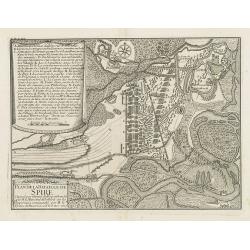
Plan de la bataille de Spire Gagnée par l'armée du Roy comandée par M. le Marechal de Tallard. . .
Showing the siege of Spire on 15 November 1703. With a lettered key A - T in upper left corner.
Date: Paris, c.1720
Selling price: ????
Please login to see price!
Sold in 2016
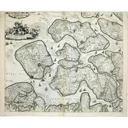
Comitatus Zelandiae tabula..
Fine map covering Zeeland, here in a re-issue by Covens and Mortier. Fine title cartouche and extensive shipping on Westerschelde and other waterways. Shows five islands:...
Date: Amsterdam, c.1720
Selling price: ????
Please login to see price!
Sold in 2014
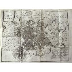
Plan de la Ville de Rome.
Unusual bird's-eye plan of Rome, by Peter van der Aa, probably after De Fer. A detailed view of the city, its expansive walls and the surrounding fields. Shows streets a...
Date: Leiden, 1720
Selling price: ????
Please login to see price!
Sold in 2011
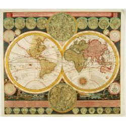
Planisphaerium Terrestre../ Vlakke Aard-kloot..
Interesting and detailed world map, cartographically up-to-date and showing the routes of explorers, including Magellan, Dampier, Tasman, Gaetani and Chaumont. Nova Brita...
Date: Amsterdam, 1700 - ca.1720
Selling price: ????
Please login to see price!
Sold in 2011
![[No tittle] De l'univers, déjà parcouru tant de fois, l'histoire achieve en ce volume. . . .](/uploads/cache/31600-250x250.jpg)
[No tittle] De l'univers, déjà parcouru tant de fois, l'histoire achieve en ce volume. . . .
Frontispiece for volume one of the "Atlas Historique," designed and engraved by Bernard Picart. The engraving shows classical muses representing, Geography, usi...
Date: Amsterdam, 1720
Selling price: ????
Please login to see price!
Sold in 2011

Jehan ou Jehon Gure, mort en 1627. / Gha Jehan ou Kourum, mort en 1665. / Oranzeb, mort en 1707. / Badour Siah, On ignore le tems de sa mort.
A striking and highly detailed copper engraved plate including 4 Indian Raja's Portraits. From Chatelain's 'Atlas Historique', 1732-1739. In upper right margin: 'Tom. V. ...
Date: Amsterdam, 1720
Selling price: ????
Please login to see price!
Sold in 2011

Jehan Darsiac. / Ferrog Sier. / Pompe & Ceremonie de la Marche du Grand Mogol.
From Chatelain's Atlas Historique, 1732-1739. In upper right margin: 'Tom. V. No 39. Pag: 110. Striking and highly detailed copper engraved plate including 2 Indian Raja'...
Date: Amsterdam, 1720
Selling price: ????
Please login to see price!
Sold in 2016

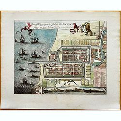
Waere Affbeeldinge Wegens het Casteel ende Stadt BATAVIA Gelegen opt Groot Eylant Java.
A good impression of this finely engraved and detailed plan of Batavia, present-day Jakarta, the Dutch center of trading activities in the East Indies. Copied after Cleme...
Date: Amsterdam, 1721
Nouvaux Mappemonde ou globe terrestre avec des tables et des ..
This impressive double hemisphere is a wonderful example of Chatelain?s elegant maps. Included in the 1721 edition of Atlas Historique, published by Chatelain in Amsterda...
Date: Amsterdam 1721
Selling price: ????
Please login to see price!
Sold
Nouvelle carte des conciles generaux et particuliers ..
Very handsome map of the lands bordering the Mediterranean Sea, including Great Britain and the Black Sea. The map was drawn to show the cities, & towns where Ecclesi...
Date: Amsterdam 1721
Selling price: ????
Please login to see price!
Sold
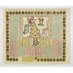
Cart Pour L'Introduction à L'Histoire D'Angleterre ..
Decorative and elaborate map of the British Isles, with portraits of the British Kings and Emperors from 801 (Egbert) to 1702 (Anne). The center map Includes two ancient ...
Date: Amsterdam 1721
Selling price: ????
Please login to see price!
Sold
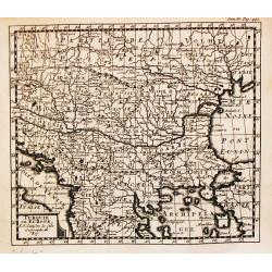
Turquie en Europe.
A nice little map of Greece.
Date: Amsterdam, 1721
Selling price: ????
Please login to see price!
Sold
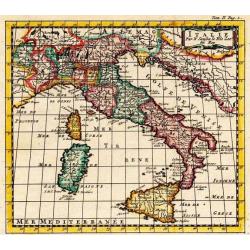
Italie.
A nice little map of Italy.
Date: Amsterdam, 1721
Selling price: ????
Please login to see price!
Sold
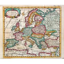
Europe.
A nice little map of the European continent.
Date: Amsterdam, 1721
Selling price: ????
Please login to see price!
Sold
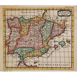
Espagne.
A nice little map of Spain,
Date: Amsterdam, 1721
Selling price: ????
Please login to see price!
Sold
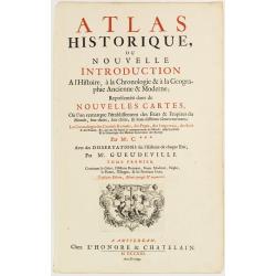
(Title page) Atlas Historique, ou Nouvelle Introduction à l'Histoire, à la Chronologie..
Decorative frontispiece printed in red and black letter press with in lower part a decorative copper engraving with putti, above the text Ubertas ex foedere et pace.After...
Date: Amsterdam 1721
Selling price: ????
Please login to see price!
Sold
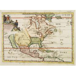
Amerique Septentrionale Par N.Sanson d\'Abbeville Geograph du Roy.
A general map of North America showing California as an island but with few names.From the book \"Nouvelle Relation, Contenant LES VOYAGES DE THOMAS GAGE dans la nou...
Date: Amsterdam, 1721
Selling price: ????
Please login to see price!
Sold

L' Asie?l' Afrique..l' Amerique.
Henri Abraham Chatelain was a Amsterdam-based geographer and publisher. His main product is the 'Atlas Historique et Méthodique', in seven volumes, published between 171...
Date: Amsterdam, 1721
Selling price: ????
Please login to see price!
Sold
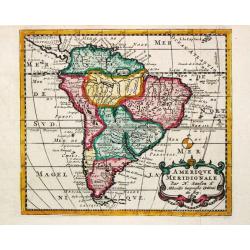
Amerique Meridionale.
A nice small map of South America.
Date: Amsterdam, 1721
Selling price: ????
Please login to see price!
Sold in 2008
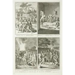
Convoi funebre des Mexiquains. / Presens que les Mexiquains font a leurs morts. / Les Habitans de Venezuela boivent les cendres ... / Les Habitans de Venezuela pleurent ...
Four prints in one sheet depicting funeral customs in Mexico.
Date: Amsterdam, 1721
Selling price: ????
Please login to see price!
Sold in 2011
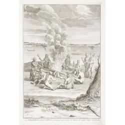
Les Virginiens, adorent le Feu, ...
Print depicting a gathering around a fire in Virginia.
Date: Amsterdam, 1721
Selling price: ????
Please login to see price!
Sold in 2011
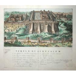
Temple de Jerusalem
This fine copper engraved view of the temple and surrounding city is full of activity, with hundreds of people, animals, and carriages. It is based on the plan of Villalp...
Date: Amsterdam, 1721
Selling price: ????
Please login to see price!
Sold in 2009
A Map of Hungary and Countries adjacent.
An uncommon English edition of De Wit's map of Scandinavia, 'revised by I.Senex' for inclusion in his atlas of 1721, re-engraved by John Harris. These revisions appear to...
Date: London, 1721
Selling price: ????
Please login to see price!
Sold in 2009
Moscovey in Europe from the latest Observations. . .
Fine, highly detailed map of the regions of European Russia by John Senex. Each region is depicted in original outline color, and a small decorative cartouche is in the t...
Date: London, 1721
Selling price: ????
Please login to see price!
Sold in 2010
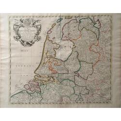
The Dutch Netherlands or the Seven United Provinces Commonly Called Holland.
A map of the Northern part of the Netherlands by John Senex which depicts major cities, including Antwerp, Brugge and Breda, as well as main rivers and lakes in the regio...
Date: London, 1721
Selling price: ????
Please login to see price!
Sold in 2010
Carte marine de la Mer Caspienne...
Map of the Caspian sea with the Volga delta and the city of Astrakhan, with 8 inset maps of islands and coast lines.
Date: Paris, 1721
Selling price: ????
Please login to see price!
Sold in 2015
Les Indes Orientales sous le Nom de queles est compris L'Empire du Grand Mogol, Les Deux Presqu'Isles Deca et de la Le Gange, Les Maldives, et L'Isle de Ceylan...
Rare map of Southeast Asia, showing India, Tibet, parts of China with Canton, Malaysia, Singapore (Sincapur), Thailand, Sumatra, the Maledives, parts of Borneo and Java. ...
Date: Paris, 1721
Selling price: ????
Please login to see price!
Sold in 2015
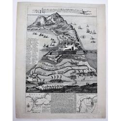
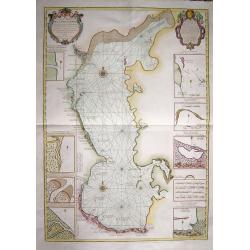
A Plan of the Famous Town & Fortress of Ceuta, Besieg'd by the Moors in 1693 & raid by ye Spaniards after 26 Years Siege in 1720. . .
A very rare separately published broad sheet map of Ceuta, with two insets of Gibraltar and explanatory text, as well as 29 keys, explaining the various strongholds and i...
Date: London, 1721
Selling price: ????
Please login to see price!
Sold in 2020

Discus Chronologicus in quo Omnes Imperatores et Reges orbis Europaei . . .
A fascinating chart in the form of a dial with a moving pointer, providing a chronology of the Holy Roman Emperors, Popes and kings of Europe from AD to 1721. The names o...
Date: Nuremberg, 1721
Selling price: ????
Please login to see price!
Sold in 2020
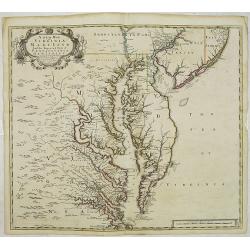
A New Map of Virginia Mary=Land And The Improved Parts of Penn=sylvania & New Jersey Most humbly Inscribed to the Right Hon.ble the Earl of Orkney . . . 1719..
Christopher Browne's map was first published, as a separate issue, in 1685. John Senex obtained the plate and, changed only the imprint, republished it in his atlas of 17...
Date: London, 1721
Selling price: ????
Please login to see price!
Sold in 2012
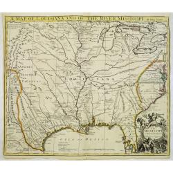
A map of Louisiana and of the Mississipi.
A scarce first English version of the influential map published by Guillaume De L'Isle in 1718.The original was a landmark map in the cartography of the region, centered ...
Date: London, 1721
Selling price: ????
Please login to see price!
Sold
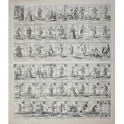
Pasquins Windkaart op de Windnegotie van 't Iaar 1720.
Undivided engraved sheet of 54 pictorial playing cards. Engraving on mounted paper.This is an early 18th-century uncut playing card sheet based on the disastrous collapse...
Date: Amsterdam, 1721
Selling price: ????
Please login to see price!
Sold in 2013
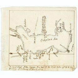
An exact Chart of the Caspian Sea Sent by the Czar Peter 1st to the Royal Academy of Sciences at Paris 1721.
A English contemporary manuscript copy of a map the Caspian Sea drawn by the Czar's special command, Carl van Verden in the year 1719. 1720 and 1721.Around 1718 Russian T...
Date: Probably, England, shortly after 1721
Selling price: ????
Please login to see price!
Sold in 2014
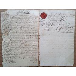
1721 Cape of Good Hope debenture, signed by 4 future COGH Governors, with intact VOC wax seal and 1714 revenue stamp.
This is a fascinating two-page document that needs further research. Written in very readable Dutch, a limited translation reveals that it seems that Jan Spoor (who is ...
Date: Cape of Good Hope, 1721
Selling price: ????
Please login to see price!
Sold in 2015
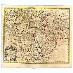
A map of Turkey Arabia and Persia . .
Fine map of Arabia, Egypt, Turkey, Greece, Persia and Mediterranean with decorative title cartouche flanked by a Greek and a Turk, based on the work of Guillaume De L'Isl...
Date: London, 1721
Selling price: ????
Please login to see price!
Sold in 2016
A New Map of India & China From the latest Observations. . .
Fine map of Indonesia, India, China, Philippines, Japan, Korea and Taiwan, with decorative title cartouche. With dedication to the directors of the English East India Com...
Date: London, 1721
Selling price: ????
Please login to see price!
Sold in 2016
La France divisée par provinces ou sont exactement remarquées toutes les routes des postes du royaume suivant qu'elles sont actuellement établies.
A large and unusual map of France showing the postal routes and post stations includes Switzerland, Luxembourg, parts of Spain, Italy, and Germany.Decorated with a large ...
Date: Paris, 1721
Selling price: ????
Please login to see price!
Sold in 2016
Waere Affbeeldinge Wegens het Casteel ende Stadt BATAVIA Gelegen opt Groot Eylant Java.
Excellent impression of Batavia's finely engraved and detailed plan, present-day Jakarta, the Dutch center of trading activities in the East Indies. Copied after Clement ...
Date: Amsterdam, 1721
Selling price: ????
Please login to see price!
Sold in 2016
![Flandria et Zeelandia Comitatus. / A Map of the County of Flanders. [Two maps]](/uploads/cache/40598-250x250.jpg)
Flandria et Zeelandia Comitatus. / A Map of the County of Flanders. [Two maps]
[Two maps] First map is a decorative, large map including Flanders and Zeeland. The map, originally engraved in 1641 for Sanderus Flandria Illustrata, and was used at dif...
Date: Amsterdam, ca. 1645 - London, 1721
Selling price: ????
Please login to see price!
Sold in 2018
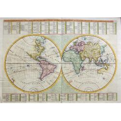
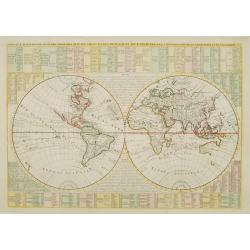
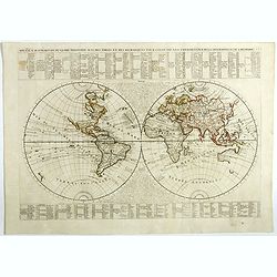
NOUVEAUX MAPPEMONDE OU GLOBE TERRESTRE AVEC DES TABLES ET DES REMARQUES POUR CONDUIRE A LA CONNOISSANCE DE LA GEOGRAPHIE ET DE L'HISTOIRE.
An impressive double hemisphere world map that is a beautiful example of Chatelain's elegant maps. From the 1721 edition of Atlas Historique, published by Chatelain in Am...
Date: Amsterdam, 1721
Selling price: ????
Please login to see price!
Sold in 2019
![Carte Marine De La Mer Caspiene.. [together with] Coste de Perse sur la Mer Caspienne...](/uploads/cache/41944-250x250.jpg)
Carte Marine De La Mer Caspiene.. [together with] Coste de Perse sur la Mer Caspienne...
A two-sheet map "Coste de Perse sur la Mer Caspienne…" together with "Carte Marine de la mer Caspienne. Par Guillaume Delisle Premier Geograp. he du Roy....
Date: Paris, ca 1721
Selling price: ????
Please login to see price!
Sold
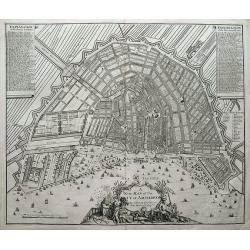
A new map of the city of Amsterdam. . .
A detailed and decorative plan of the city. With numerous streets, windmills, buildings, and sailing ships. 288 streets and 26 buildings are named in the legends. Decorat...
Date: London, 1721
Selling price: ????
Please login to see price!
Sold in 2018
Nouvaux Mappemonde ou globe terrestre avec des tables et des ..
This impressive double hemisphere is a wonderful example of Chatelain’s elegant maps. Included in the 1721 edition of Atlas Historique, published by Chatelain in Amster...
Date: Amsterdam, 1721
Selling price: ????
Please login to see price!
Sold in 2023
![Carte du Gouvernement de l' Amerique [California Island].](/uploads/cache/82994-250x250.jpg)
Carte du Gouvernement de l' Amerique [California Island].
An interesting chart depicting the European possessions in North and South America. A wonderful example of Chatelain’s elegant maps. Included in the 1721 edition of the...
Date: Amsterdam, 1721
Selling price: ????
Please login to see price!
Sold in 2019
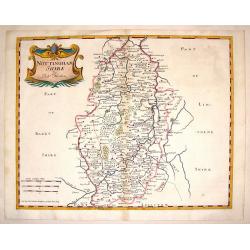
Nottinghamshire.
Detailed map of Nottingham with the early road system, cities & towns,lakes and rivers and forests and mountains. Adorned with an interesting title cartouche. Robert...
Date: London, 1722
Selling price: ????
Please login to see price!
Sold in 2014
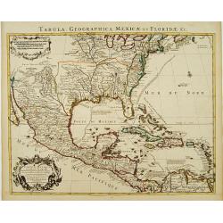
Carte du Mexique et de la Floride des Terres Angloises et des Isles Antilles. . .
Covens & Mortier's issue of Delisle's important map showing the south-eastern part of the United States, Mexico and the Caribbean Sea. It is credited with accurately ...
Date: Amsterdam, c. 1722
Selling price: ????
Please login to see price!
Sold in 2016
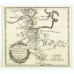
Carte de la route de M. Zurabek, ambassadeur de S.M. polonoise à Cha-Ussein roi de Perse depuis Chamakié jusqu'à Hispahan. . .
Rare map, shows North West Persia and the southern parts of the Caspian Sea with the route of the Polish Ambassador Zurabek to Persia. Engraved by Claude-Auguste de Berey...
Date: Paris, ca. 1722
Selling price: ????
Please login to see price!
Sold in 2014
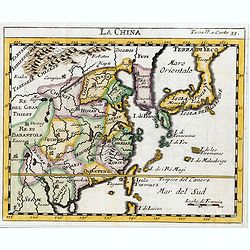
La Chine.
The map is of interest for the use of Sea of Japan / East Sea, the sea between Korea and Japan, here called "Mer Orientale".This small Italian map of China, Kor...
Date: Venice, c.1722
Selling price: ????
Please login to see price!
Sold in 2023