Browse Listings in Europe > Russia / Baltic / Black Sea region
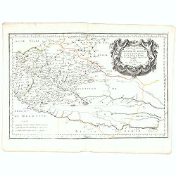
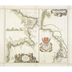
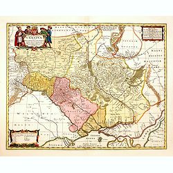
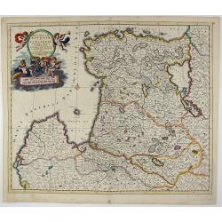
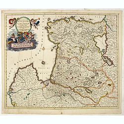
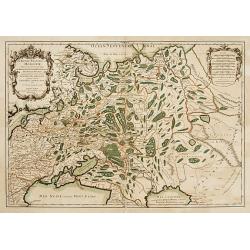
Basse Podolie, Palatinat de Braclaw tiré de la grande Ukraine du Sieur le Vasseur de Beauplan / par le Sr. . .
Scarce and fine map of Ukraine after Guillaume Le Vasseur de Beauplan (c. 1600 — December 6 1673), who was a French cartographer, engineer and architect. Beauplan serve...
Date: Paris, 1665
Selling price: ????
Please login to see price!
Sold in 2025
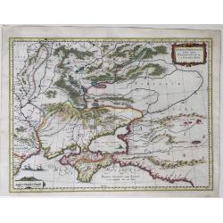
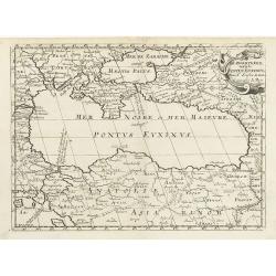
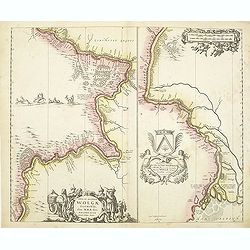
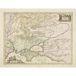
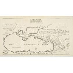
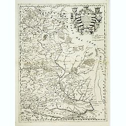
Taurica Chersonesus Nostra aetate Przecopsca et Gazara dicitur.
A map showing the area between the northern coast of the Black Sea, the present day Ukraine and part of Russia, with the Crimean including the mouth of the Danube River a...
Date: Amsterdam, 1662-1665
Selling price: ????
Please login to see price!
Sold in 2022
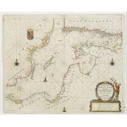
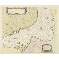
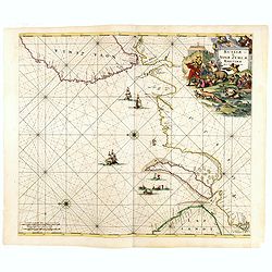
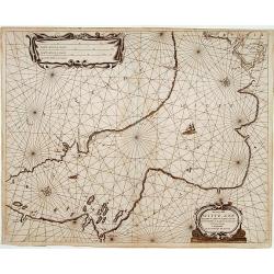
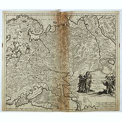
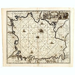
Pas-Caart van de Oost Zee verthooende alle de ghelegenheydt tusschen t Eylandt Rugen ende Wyborg. . .
An eye-catching chart of the Baltic Sea. Engraved by Gerard Coeck.Pieter Goos (ca. 1616-1675) was one of the most important cartographer, engraver, publisher and print se...
Date: Amsterdam, 1666
Selling price: ????
Please login to see price!
Sold in 2009
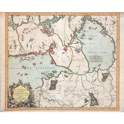
La Carelie, et l'Ingrie, ou Ingermenland. . .
Map of the gulf of Finland and Lake Ladoga and the River Neva. Interesting pre-Saint Petersburg map. The island Retusari, now known as the Kotlin Island is shown. This is...
Date: Paris, P.Mariette, 1666
Selling price: ????
Please login to see price!
Sold in 2009
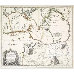
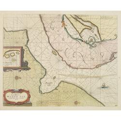
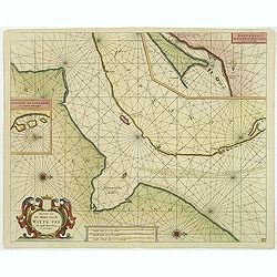
Pascaart van de Witte-Zee begrypende de custen van Laplandt, van Warsiga tot aen Kandalox en de cust van Corelia tot aen de Riviere Dwina.
A decorative chart of the White Sea, embellished with two finely colored title and scale cartouches, 2 ships and 2 compass-roses. With west to the top. In lower right cor...
Date: Amsterdam, 1666
Selling price: ????
Please login to see price!
Sold in 2010
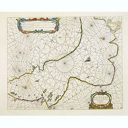
Pascaert van de mont van de Witte Zee tot aende Rivier Dwina al Archan : gel toe.
Three charts on one sheet. A decorative chart of the connection between the White Sea and the Barents Sea, embellished a finely colored title-cartouches, a ship and 2 com...
Date: Amsterdam, 1666
Selling price: ????
Please login to see price!
Sold in 2010
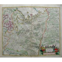
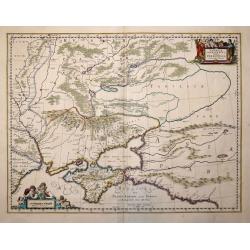
Partie de Lithuanie ou sont en partie les Palatinats de Minsk, et Mseislaw, we les Seign.Ries ou Terres de Rohaczow, Rzeczica, Zernobee, et partie des. . .
Fine map of Lithuania. This edition carries the date 1665 and the publishers address "A Paris, chez l'Autheur". Nicolas Sanson was to bring about the rise of Fr...
Date: Paris, 1666
Selling price: ????
Please login to see price!
Sold in 2011
Illyricum Orientis In quo Partes II. Moesia et Thracia. Provinciae XI.
Attractive historical map of the area west of the Black Sea, today's Bulgaria, Rumania, etc. Based on the cartography of Nicolas Sanson and published by P.Mariette. With ...
Date: Paris, 1666
Selling price: ????
Please login to see price!
Sold in 2020
La Carelie et l'Ingrie, ou Ingermenland.
Depicts the gulf of Finland, Lake Ladoga and the River Neva. Pre-Saint Petersburg map.
Date: Paris, P.Mariette, 1666
Selling price: ????
Please login to see price!
Sold in 2018

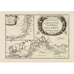
Relation du voyage en Moscovie, Tartarie, et Perse, augmentee en cette nouvelle edition... Le voyage de Jean Albert de Mandelslo aux Indes Orientales.
Complete title 'Relation du voyage en Moscovie, Tartarie, et Perse, augmentee en cette nouvelle edition... Le voyage de Jean Albert de Mandelslo aux Indes Orientales. Tra...
Date: Paris, 1666
Selling price: ????
Please login to see price!
Sold in 2017
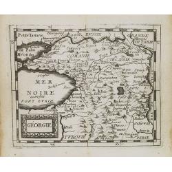
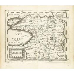
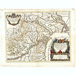
Turcomanie Georgie Commanie. . .
Attractive general map of Caucasus Mountains, Armenia and Georgia prepared by N.Sanson and published by Pierre Mariette.Published in an early edition of the small Sanson ...
Date: Paris, P. Mariette, 1667
Selling price: ????
Please login to see price!
Sold in 2008
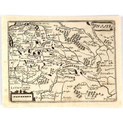
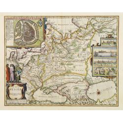
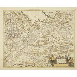
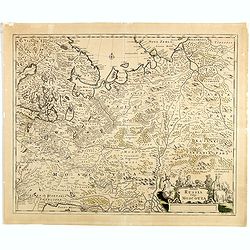
Russie.
Rare map of Russia published by Jollain in 1667. Published in "Trésor Des Cartes Geographiques Des Principaux Estats de Lunivers". This atlas is based upon Bo...
Date: Paris, 1667
Selling price: ????
Please login to see price!
Sold in 2018
Ducatuum Livoniae et Curlandiae.
Nice engraved map of Estonia and Lithuania and parts of Russia. Decorative title cartouche supported by cherubs in the upper left corner.
Date: Amsterdam ca 1670
Selling price: ????
Please login to see price!
Sold
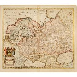
Tabula Russia Vulgo Moscovia.
A detailed map including all western Russia and most of Finland. With very decorative title cartouche.
Date: Amsterdam, 1670
Selling price: ????
Please login to see price!
Sold in 2009
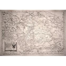
A Mapp of the Estates of the The Great Duke of Russia Blanch, or Moscovia.
A good example of Richard Blome's scarce map of Russia, the earliest folio sized map of the region to be engraved in England. The map has the naïve engraving style chara...
Date: London,1670
Selling price: ????
Please login to see price!
Sold in 2014
Tabula Russiae ex autographo, quod delineandum curavit Foedor filius Tzaris Boris desums... - Domino regionum Iueriae Kartalinie et Groefiniae Tzari etc: dedicata ab Heselo Gerardo M.DC.XIIII
re-issue, by Willem Blaeu, of Hessel Gerritsz' rare and influential map of Russia. Dutch text on verso, extending west to east from Emden to Aspachan and north to south f...
Date: Amsterdam, 1659-1672
Selling price: ????
Please login to see price!
Sold in 2010
Tabula Russiae ex autographo, quod delineandum curavit Foedor filius Tzaris Boris desums... - Domino regionum Iueriae Kartalinie et Groefiniae Tzari etc: dedicata ab Heselo Gerardo M.DC.XIIII
A re-issue, by Willem Blaeu, of Hessel Gerritsz' rare and influential map of Russia. Dutch text on verso, extending west to east from Emden to Aspachan and north to south...
Date: Amsterdam, 1659-1672
Selling price: ????
Please login to see price!
Sold in 2016
Tabula Russiae ex autographo, quod delineandum curavit Foedor filius Tzaris Boris desums... - Domino regionum Iueriae Kartalinie et Groefiniae Tzari etc: dedicata ab Heselo Gerardo M.DC.XIIII
A re-issue, by Willem Blaeu, of Hessel Gerritsz' rare and influential map of Russia. Dutch text on verso, extending west to east from Emden to Aspachan and north to south...
Date: Amsterdam, 1659-1672
Selling price: ????
Please login to see price!
Sold in 2017
Tabula Russiae ex autographo, quod delineandum curavit Foedor filius Tzaris Boris desums... - Domino regionum Iueriae Kartalinie et Groefiniae Tzari etc: dedicata ab Heselo Gerardo M.DC.XIIII
A re-issue, by Willem Blaeu, of Hessel Gerritsz' rare and influential map of Russia.Spanish text on verso, extending west to east from Emden to Aspachan and north to sout...
Date: Amsterdam, 1659-1672
Selling price: ????
Please login to see price!
Sold in 2017

Tabula Russiae ex autographo, quod delineandum curavit Foedor filius Tzaris Boris desums... - Domino regionum Iueriae Kartalinie et Groefiniae Tzari etc: dedicata ab Heselo Gerardo M.DC.XIIII
A re-issue, by Willem Blaeu, of Hessel Gerritsz' rare and influential map of Russia. Dutch text on verso, extending west to east from Emden to Aspachan and north to south...
Date: Amsterdam, 1659-1672
Selling price: ????
Please login to see price!
Sold in 2019
.Russiae et Novae Zemblae Maritimae.
This beautifully, large-scale chart, oriented with east at the top, displays the coastline from northern Russia. Covering the coast from Lapland till the west coast of No...
Date: Amsterdam, 1675
Selling price: ????
Please login to see price!
Sold in 2015
A map of Russia.
One of the most decorative maps of Russia, known for its figured borders with people in local dress, among them a Turkish woman and man. Upper panel of town panoramas of ...
Date: London 1676
Selling price: ????
Please login to see price!
Sold
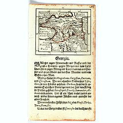
Géorgie.
Uncommon miniature map of Georgia from Pierre Duval's La Geographie Universeille dated 1676. Following his Cartes de geographie in 1657, Pierre Duval published this small...
Date: Paris, 1676
Selling price: ????
Please login to see price!
Sold in 2008
Pascaerte van de Mont van de Witte Zee tot aen de Rivier van Archangel..
Beautiful and rare chart from Nieuw en Groote Loots-Man Zee Spiegel, Ofte lichtende Colomme. Showing the mount of the White Sea. In upper right hand corner inset map of &...
Date: Amsterdam, 1676
Selling price: ????
Please login to see price!
Sold in 2011
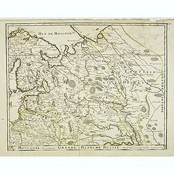
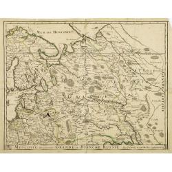
Moscovie dîte autrement la Grande Blanche Russie . . .
Detailed map by Pierre du Val of the European part of Russia including Finland, Poland and the Baltics with title along the bottom.This is the uncommon early edition with...
Date: Paris, 1676
Selling price: ????
Please login to see price!
Sold in 2014
Pascaarte van de Witte Zee begrypende de custen van Laplant..
Beautiful chart of the White Sea from Nieuw en Groote Loots-Man Zee Spiegel, Ofte lichtende Colomme. Showing the White Sea.The family name of the Lootsman brothers is The...
Date: Amsterdam, 1676
Selling price: ????
Please login to see price!
Sold in 2012
Géorgie.
Scarce miniature map of Georgia from Pierre Duval's La Geographie Universeille dated 1676. Following his Cartes de geographie in 1657, Pierre Duval published this smaller...
Date: Paris, 1676
Selling price: ????
Please login to see price!
Sold in 2015
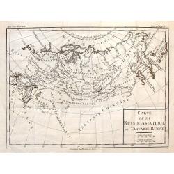
Carte de la Russie Asiatique ou Tartarie Russe.
Fine copper engraved engraving featuring the Eastern part of Russia. Engraved by Brion de la Tour and published in "HISTOIRE UNIVERSELL" by Chez Moutard in 1676...
Date: Paris, 1676
Selling price: ????
Please login to see price!
Sold in 2014
A map of RUSSIA.
A good impression from an early edition of this famous and decorative cartes-a-figures of Russia from the first world atlas produced by an Englishman - John Speed’s Pro...
Date: London 1676
Selling price: ????
Please login to see price!
Sold in 2021
Pascaarte van de Witte Zee begrypende de custen van Laplant..
Beautiful chart from Nieuw en Groote Loots-Man Zee Spiegel, Ofte lichtende Colomme. Showing the White Sea.The family name of the Lootsman brothers is Theunisz. Their fath...
Date: Amsterdam 1679
Selling price: ????
Please login to see price!
Sold
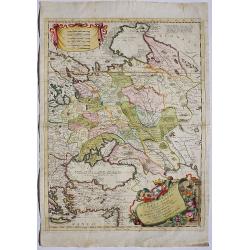
Moscovie dite autrement Grande et Blanche Russie.
Somewhat scarce map of Russia, Finland, Poland and the Baltic's.
Date: Paris, 1679
Selling price: ????
Please login to see price!
Sold in 2013
Novissima Russiae Tabula.
Detailed map of Russia including Scandinavia. Very decorative title cartouche with Russian coat-of-arms. Prepared by Isaac Masso.
Date: Amsterdam 1680
Selling price: ????
Please login to see price!
Sold
Paskaart van de Rivier de Dwina of Archangel..
Very decorative sea-chart of the River Dwina. Decorated with two large title-cartouches. Number 35 in lower right corner.
Date: Amsterdam 1680
Selling price: ????
Please login to see price!
Sold
Tabula Russia Vulgo Moscovia.
A detailed map including all western Russia and most of Finland. With very decorative title cartouche.
Date: Amsterdam 1680
Selling price: ????
Please login to see price!
Sold
Nova et accurata Wolgae Fluminis olim Rha dicti delineatio Auctore Adamo Oleario.
Showing the Volga River in two parts based on the travels of Adam Olearius. The left side of the map begins at Nazhniy Novgorod and ends at Saratov. The right side contin...
Date: Oxford, 1680
Selling price: ????
Please login to see price!
Sold in 2009
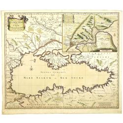
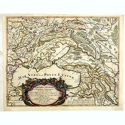
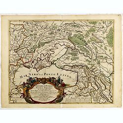
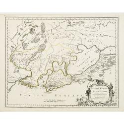
De Zwartezee, eertyts Pontus Euxinus . . .
Map encompassing part of the Near East and the area comprehended between the Black Sea and the Caspian Sea.Prepared by N.Sanson.
Date: Amsterdam, Utrecht, 1680
Selling price: ????
Please login to see price!
Sold in 2010
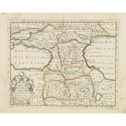
Carte du voyage de Moscovie selon la relation d'Olearius.
Rare map of the region of Baltic sea and the area west of Moscow. With an imposing title cartouche and an inset map "Le cours de l'occa en Moscovie".Basically t...
Date: Paris, 1680
Selling price: ????
Please login to see price!
Sold in 2015
Nouvelle Carte de la Mer Noire et du Canal de Constantinople.
Decorative and uncommon map the Black Sea region. In upper left hand corner an inset map (200x280) of the Bosporus including Istanbul.
Date: Amsterdam, 1680
Selling price: ????
Please login to see price!
Sold in 2011
Nova et accurata Wolgae Fluminis olim Rha dicti delineatio Auctore Adamo Oleario.
Showing the Volga River in two parts based on the travels of Adam Olearius. The left side of the map begins at Nazhniy Novgorod and ends at Saratov. The right side contin...
Date: Oxford, 1680
Selling price: ????
Please login to see price!
Sold in 2011
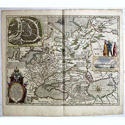
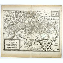
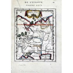
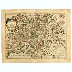
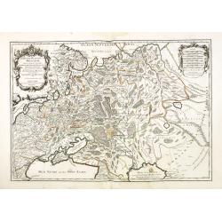
Typus Generalis Ukrainae sive Palatinatuum Podoliae, Kioviensis et Braczlaviensis terras nova delineatione exhibens. . .
Key map based on Guillaume La Vasseur de Beauplan's map of the region published in "Description d'Ukraine". The work described Ukraine as several provinces of t...
Date: Oxford, 1680
Selling price: ????
Please login to see price!
Sold in 2014
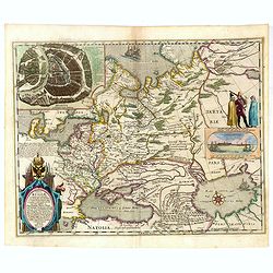
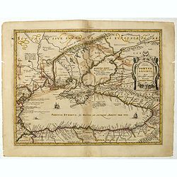
Taurica Chersonesus Hodie Przecopsca et Gazara dicitur. . .
Map shows the Ukraine with the island of Crimea.
Date: London,1680
Selling price: ????
Please login to see price!
Sold in 2014
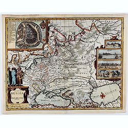
Novissima et Accuratissima Totius Russiae Vulgo Muscoviae Tabula at Iusto Danckerts . . .
Interesting map of Western Russia and Ukraine, published by Justus Danckerts. The map extends from the northern tip of the Black and Caspian Seas to the Mare Mosovia and ...
Date: Amsterdam, 1680
Selling price: ????
Please login to see price!
Sold in 2015
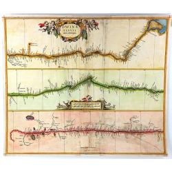
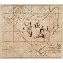
Dwinae Fluvii Nova Deseripio.
An unusual early map, showing the course of the Dvina River in three separate panels in strip map style. With the headwaters at bottom left, and with the mouth at Archang...
Date: Amsterdam, 1680
Selling price: ????
Please login to see price!
Sold in 2016
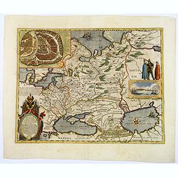
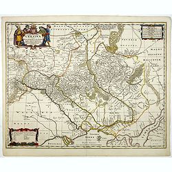
Typus Generalis Ukrainae sive Palatinatuum Podoliae, Kioviensis et Braczlaviensis terras nova delineatione exhibens. . .
Key map based on Guillaume La Vasseur de Beauplan's map of the region published in "Description d'Ukraine". The work described Ukraine as several provinces of t...
Date: Nuremberg, ca. 1680
Selling price: ????
Please login to see price!
Sold in 2016
Typus Generalis Ukrainae sive Palatinatuum Podoliae, Kioviensis et Braczlaviensis terras nova delineatione exhibens. . .
Keymap based on Guillaume La Vasseur de Beauplan's map of the region published in "Description d'Ukraine." The work described Ukraine as several provinces of th...
Date: Oxford, 1680
Selling price: ????
Please login to see price!
Sold in 2020
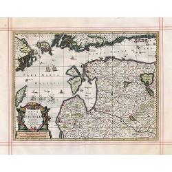
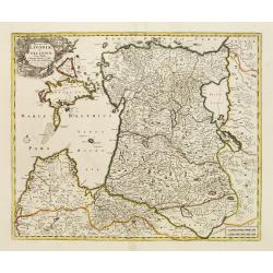
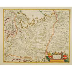
Nova Totius Livoniae accurata Descriptio.
Antique map of the Baltic States Estonia & Latvia
Date: Oxford, 1680
Selling price: ????
Please login to see price!
Sold in 2017
Ducatuum Lovoniae et Curlandiae Novissima Tabula in Quibus sunt Estonia ...
A rare and decorative map of Estonia, part of Latvia, Lithuania and Russia.
Date: Amsterdam, 1680
Selling price: ????
Please login to see price!
Sold in 2018
Taurica Chersonesus, Hodie Przecopsca, at Gazara dicitur.
Detailed map of the Ukraine and surrounding regions between the northern coast of the Black Sea and Moscow. Shows ports, fortified cities and the mouths of the Danube. Tw...
Date: Oxford, 1681
Selling price: ????
Please login to see price!
Sold in 2013
Die Caspische oder Hyrcanische See.
Strikingly engraved and attractive map of the Caspian Sea, showing major towns, ports, etc. Large decorative cartouche and compass rose. The engraving is neatly executed,...
Date: Nüremberg, Johann Hoffmanns, 1681
Selling price: ????
Please login to see price!
Sold in 2019
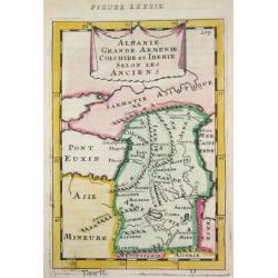
Albanie, Grande Armenie, Colchide et Iberie selon les Anciens.
Alain Manneson Mallet (1603-1706) published in 1683 his ' Description de l' Univers' in 5 volumes. In 1686 a German edition appeared.
Date: Paris, 1683
Selling price: ????
Please login to see price!
Sold in 2010
Moscovie.
Small scale map of European Russia from Allain Manesson Mallet's Description de L'Univers. Accompanying French text on verso. Allain Manesson Mallet (1630-1706) began his...
Date: Paris, 1683
Selling price: ????
Please login to see price!
Sold in 2010
Tartaria D Europa ouero Piccola Tartaria divisa da Giacomo Cantelli da Vignola ne Tartari Nogai e del Crim, o di Precop . . .
Rare map of the Ukraine, Georgia, Muscovy, Southeastern Poland / Lithuania and the Black Sea. With an ornate allegorical cartouche.The cartographer of this map is Giacomo...
Date: Rome, 1683
Selling price: ????
Please login to see price!
Sold in 2022
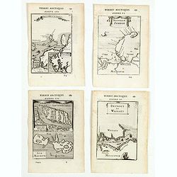
(Four engravings of Russian interest from Description de l\'Univers)
Finely etched maps entitled Spitzberg et N. Zemble, Nouvelle Zemble, Isle des Etats Staten-Eyland, Detroit de waigats. From the French text edition of Description d'Unive...
Date: Paris, 1683
Selling price: ????
Please login to see price!
Sold in 2015
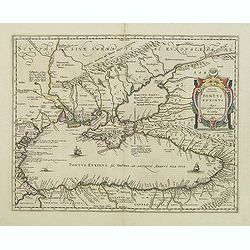
Pontus Euxinus Aequor Iafonio pulfatum remige premum.
Prepared by Ortelius after Mercator, and additional ancient sources as Plinius, Ovidius, Strabo, Apollonius, Procopius and Apianus.This map belongs to a series of histori...
Date: Amsterdam, 1652-1684
Selling price: ????
Please login to see price!
Sold in 2011
Tartaria D Europa ouero Piccola Tartaria divisa da Giacomo Cantelli da Vignola ne Tartari Nogai e del Crim, o di Precop . . . ne Tartari di Budziack, D'Oczackow, e di Dobrus . . .Tartari Circassi . . .
Engraved by Vin Mariotti. Giacomo Rossi's fine late 17th century map of the Ukraine, Georgia, Muscovy, Southeastern Poland / Lithuania and the Black Sea. Issued in Il Mer...
Date: Rome, 1684
Selling price: ????
Please login to see price!
Sold in 2015
Pontus Euxinus Aequor Iafonio pulfatum remige premum.
Prepared by Ortelius after Mercator, and additional ancient sources as Plinius, Ovidius, Strabo, Apollonius, Procopius and Apianus.This map belongs to a series of histori...
Date: Amsterdam, 1652-1684
Selling price: ????
Please login to see price!
Sold in 2019
Ducatuum Lovoniae et Curlandiae Novissima Tabula in Quibus sunt Estonia Litlandia et Alir Minorus Provincae Per Iustum Danckerts Amstelodami cum Privilegio Ord: Hollandiae et West-Friesiae.
A rare and decorative map of Estonia, part of Latvia, Lithuania and Russia with a very beautiful cartouche of 2 putti carrying the title and 2 putti supporting 2 coat-of-...
Date: Amsterdam, 1684
Selling price: ????
Please login to see price!
Sold in 2021
Ponti euxini cum regionibus versus septentrionem et orientem adjacentibus nova tabula.
A rare map of the Black Sea area from the travels of Sir Joan Chardin ( 1643-1713.) into Persia and the East Indies. See Copac . John Chardin (1643-1712) was the son of a...
Date: London, Moses Pitt, 1686
Selling price: ????
Please login to see price!
Sold in 2010
Descritione delli principati della Moldavia e Valachia / tolta da Giacomo Cantelli da Vignola.
Scarce map of the region between the Danube, Nistru, and Dnieper Rivers along the Black Sea - present-day Ukraine and Romania. Excellent detail throughout. Large and deco...
Date: Rome, 1686
Selling price: ????
Please login to see price!
Sold in 2018
Nieuwe lantkarte Van het Noorder en Ooster deel van Asia en Europa strekkende van Nova Zemla to China. . .
Three parts on one sheet. Part from large wall map. Containing a dedication to Peter Aleksejewitsj (later known as czar Peter the Great). Prepared by Nicolas Witsen, Burg...
Date: Amsterdam, 1687
Selling price: ????
Please login to see price!
Sold in 2016

TAURICA CHERSONESUS. Hodie CRIMEA.
An uncolored very rare copperplate map showing the Crimea peninsula. At the top there's a camel carriage with a tartar.
Date: Nuremberg, 1687
Selling price: ????
Please login to see price!
Sold in 2017
![[Central Europe ]](/uploads/cache/30324-250x250.jpg)
[Central Europe ]
Charming wood block map of Central Europe with Prague in the center, Poland, Germany, Switzerland and Austria are also included. Map by the Italian XVIth and XVIIth centu...
Date: Bologna, Antonio Pisarri, 1594 - 1688
Selling price: ????
Please login to see price!
Sold
![[ Black Sea region, Russia ]](/uploads/cache/30323-250x250.jpg)
[ Black Sea region, Russia ]
Charming wood block map of the Black Sea region, in the north reaching till Moscow by the Italian XVIth and XVIIth century writer, humanist and cartographer Giuseppe Rosa...
Date: Bologna, Antonio Pisarri, 1594 - 1688
Selling price: ????
Please login to see price!
Sold in 2011
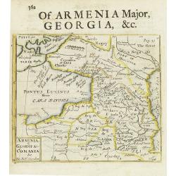
Armenia - Georgia - Comania. . .
A miniature map shows the Black Sea's east coast up to the Caspian Sea, published by Robert Morden. Copper engraved map with letterpress text describing Georgia.
Date: London, 1688
Selling price: ????
Please login to see price!
Sold in 2015
Russia Bianca o Moscovia...
Fine map engraved by Giorgio Widman. Giacomo Rossi's fine late 17th-century map of Russia. Issued in Il Mercurio geografico In upper left-hand corner large title cartouch...
Date: Rome, 1678-1688
Selling price: ????
Please login to see price!
Sold in 2015
Tabula Russia Vulgo Moscovia.
A detailed map including all western Russia and most of Finland. With very decorative title cartouche.
Date: Amsterdam, 1690
Selling price: ????
Please login to see price!
Sold in 2011
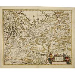
Tabula Russia Vulgo Moscovia.
A detailed map including all western Russia and most of Finland. With very decorative title cartouche.
Date: Amsterdam, 1690
Selling price: ????
Please login to see price!
Sold in 2010
Tabula Russia Vulgo Moscovia.
A detailed map including all western Russia and most of Finland. With very decorative title cartouche.
Date: Amsterdam, 1690
Selling price: ????
Please login to see price!
Sold in 2014
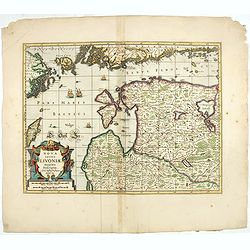
Nova Totius Livoniae accurata Descriptio.
The excellent, and decorative map of Livonia from the Moses Pitt "The English Atlas". Map extent is southern most tip of Sweden, part of the southern coast of F...
Date: Oxford, 1690
Selling price: ????
Please login to see price!
Sold in 2023
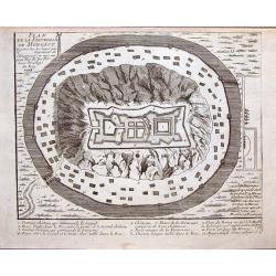
Plan de la Forteresse de Mongast.
Fine copper-engraved bird's eye view of the hilltop castle of Mukacheve, then an important stronghold of the Hungarian Empire. The castle is surrounded by a moat and is o...
Date: Amsterdam, 1692
Selling price: ????
Please login to see price!
Sold in 2014
Tartaria Crimea.
A lovely miniature map of the region of Armenia and Georgia, showing both parts of the Black Sea and Caspian Sea. For such a small map it renders a wealth of detail, with...
Date: Ulm, 1692
Selling price: ????
Please login to see price!
Sold in 2023
Parte Orientale Dell' Europa, Descritta, e Dedicata Dal P. Cosmografo Coronelli All Illustrissimo, et Eccellentissimo Signore Giovanni da Mula, Senatore amplissimo Nella Serenissima Republica de Venetia.
A beautiful and finely detailed map including the regions of Eastern Europe, Russia, Turkey, the Caspian Sea and Novaya Zemlya by Vincenzo Coronelli, and dedicated to Gio...
Date: Venice, 1692
Selling price: ????
Please login to see price!
Sold in 2017
Cimmeria quae Postea Scythia Europaea..
Fine map of the northern part of the Black Sea.
Date: Paris, 1694
Selling price: ????
Please login to see price!
Sold
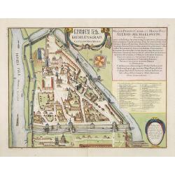
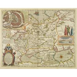
? Kremlenagrad Castellum Urbis Moskuae.
Detailed bird's-eye view of the Kremlin from Frederick de Wit's rare town book. With a key (1-20) to important spots in town. Frederick de Wit published after 1694 a town...
Date: Amsterdam, ca. 1694
Selling price: ????
Please login to see price!
Sold in 2009
Nova Ducatus et praefecturae Normanniae..
Uncommon map of Russia. Decorated with large title and scale cartouches.
Date: Paris 1695
Selling price: ????
Please login to see price!
Sold
![Parte orientale dell' Europa . . . [Russia]](/uploads/cache/29452-250x250.jpg)
Parte orientale dell' Europa . . . [Russia]
Eastern part of Europe. The map extends from the Turkey (with Cyprus) and the Black sea, Ukraine and part of the Caspian Sea, up till Nova Zembla. Only the west coast of ...
Date: Venice, 1695
Selling price: ????
Please login to see price!
Sold in 2010
Polonia parte Orientale.
Uncommon map of the Ukraine, all engraved in Coronelli's strong and distinctive style. In upper right corner a imposing dedicational cartouche surmounted by coats of arms...
Date: Venice, 1695
Selling price: ????
Please login to see price!
Sold in 2012
La Russie Blanche ou Moscovie..
European Russia, including Poland and Ukraine. The relief of the landscape is shown and the regions are distinguished by kingdoms, dukedoms, principatlities, provinces an...
Date: Paris, ca. 1695
Selling price: ????
Please login to see price!
Sold in 2013
![Parte orientale dell' Europa . . . [Eastern part of Europe with Russia and map of Iceland on verso]](/uploads/cache/39638-250x250.jpg)
Parte orientale dell' Europa . . . [Eastern part of Europe with Russia and map of Iceland on verso]
Eastern part of Europe of a two sheet map. On the verso a map of Iceland "Isola d'Islanda". The Europe map extends from the Turkey (with Cyprus) and the Black s...
Date: Venice, 1695
Selling price: ????
Please login to see price!
Sold in 2020
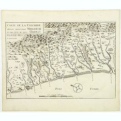
Carte de la Colchide appelée maintenant Mengrelie et pars ceux du pays Odisci.
An early map showing the extent of the fortifications of the Ottoman Empire along the east of the Black Sea and in the foothills of the Caucasus. Vignettes of buildings, ...
Date: Paris, 1664-1696
Selling price: ????
Please login to see price!
Sold in 2011
