Browse Listings in Europe > France > France Provinces
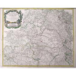
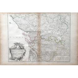
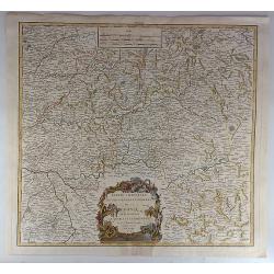
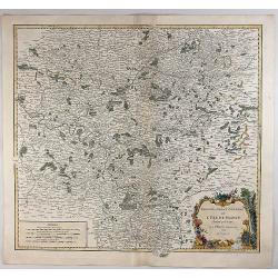
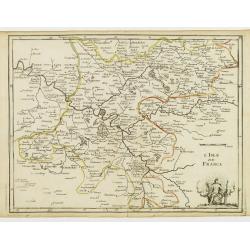
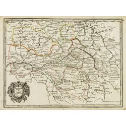
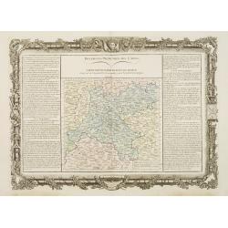
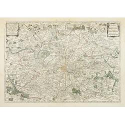
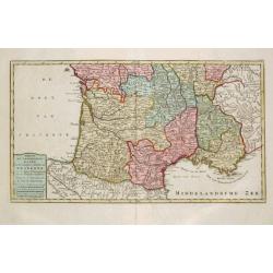
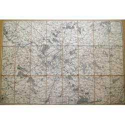
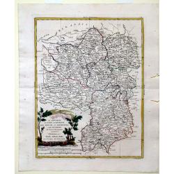
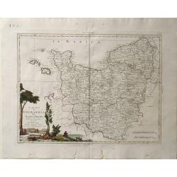
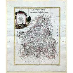
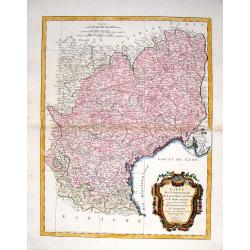
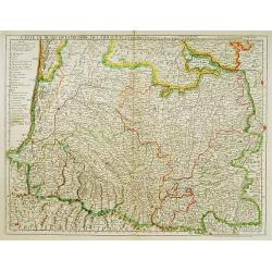
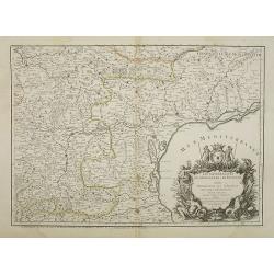
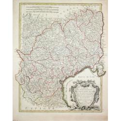
Partie septentrionale du Gouvernem? general de Champagne....
Very detailed map of the northern part of the famous Champagne region, centered on Reims. Includes towns, mountains, rivers, lakes, etc. With a large decorative title car...
Date: Paris, ca. 1751
Selling price: ????
Please login to see price!
Sold in 2016
Cercle de Westphalie Divise en Tout Ses Etats et Souverainetes.
A fine map of Westphalia by Vaugondy in 1751. The Lower Rhenish–Westphalian Circle was an Imperial Circle of the Holy Roman Empire. It comprised territories of the form...
Date: Paris, 1751
Selling price: ????
Please login to see price!
Sold in 2018
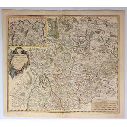
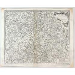
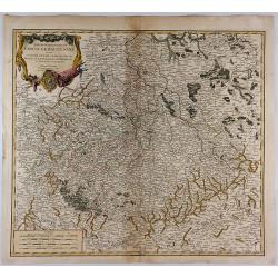
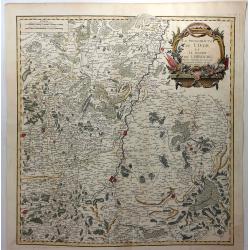
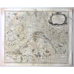
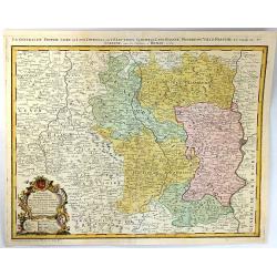
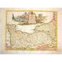
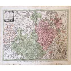
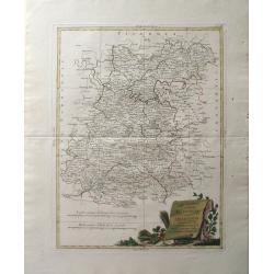
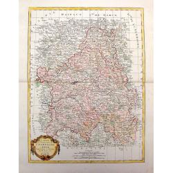
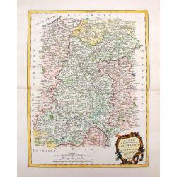
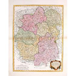
Partie Septentrionale du Gouvernement General de Bourgogne...
A detailed regional map with a large decorative Rococo cartouche. Shows fortified cities, towns, rivers, castles, churches, roads, woods, mountains, lakes, etc. It covers...
Date: Paris , 1752
Selling price: ????
Please login to see price!
Sold in 2018
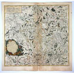
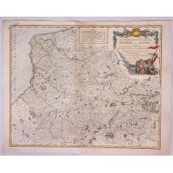
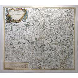
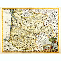
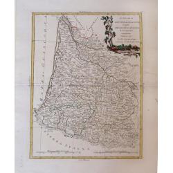
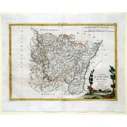
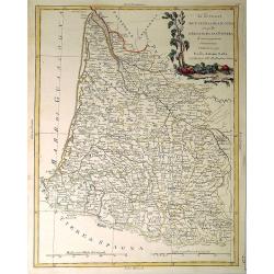
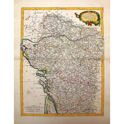
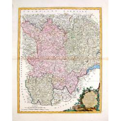
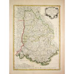
Partie Orientale du Gouvernement General de la Guienne...
A pleasing map of the Eastern Guyenne region of France by Vaugondy. It depicts the southern portion of France from Samatan east, to Bruide, and south as far as Toulouse, ...
Date: Paris, 1752
Selling price: ????
Please login to see price!
Sold in 2019
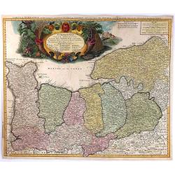
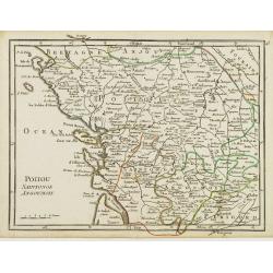
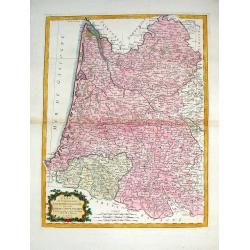
Gouvernemens Generaux du Poitou, du Pays d'Aunis, et de Saintonge-Angoumois
Map of the Poitoi-Charentes region of France, along the central western coast, showing the cities of Rochefort, Poitiers, Niort and Saintes. Ornamental cartouche is in lo...
Date: Paris: 1753
Selling price: ????
Please login to see price!
Sold in 2010
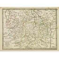
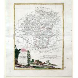
Gouvernemens Generaux de la Marche, du Limousin et de L'Auvergne.
A fine 1753 map of the Limousin, Marche and Auvergne regions of France by Robert de Vaugondy, dated 1753.It features from La Chatre south to Domme and from Perigueux east...
Date: Paris, 1753
Selling price: ????
Please login to see price!
Sold in 2017
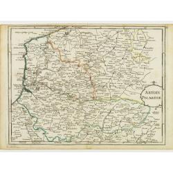
Gouvernment General de Picardie et Artois...
A beautiful de Vaugondy map of Picardy and Artois. The map covers part of the regions of Normandy (Normandie), l'Ile de France (Isle de France), and Champagne.The Pas de ...
Date: Paris, 1753
Selling price: ????
Please login to see price!
Sold in 2023
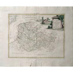
Gouvernemens Generaux du Maine et Perche de L'anjou, de la Touraine et du Saumurois.
This is a fine 1753 map of the French winemaking regions of Maine, Perche, Touraine, Anjou and Saumur. It depicts the whole or parts of the modern day departments of May...
Date: Paris, 1753
Selling price: ????
Please login to see price!
Sold in 2021
Partie Orientale du Gouvernement General de la Guenne.
An uncommon map of the Eastern Guyenne region of France, depicting the southern portion of France from Samatan east to Bruide and south as far as Toulouse, and covering t...
Date: Paris, 1753
Selling price: ????
Please login to see price!
Sold in 2019
Partie Meridionale du Cercle de Haut Saxe. . .
This is a striking map of the historic provinces of le Duche de Saxe, le Marquisat de Minnie, & le Landgravlat de Thuringe, in France. The title is inside a richly de...
Date: Paris, 1753
Selling price: ????
Please login to see price!
Sold in 2018
Gouvernements Generaux du Berry, du Nivernois et du Bourbonois.
An antique hand colored map of the Berry, Nivers, Bourbon regions of France, including Bourges and Nevers in central France. Features a decorative cartouche with fruits a...
Date: Paris, 1753
Selling price: ????
Please login to see price!
Sold in 2018
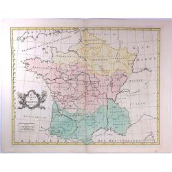
2e. Carte de France
A pleasant minimalistic map of France, featuring the French provinces and the capital of each, but with very little detail. It was engraved by Thomas Kitchin, and is date...
Date: London, 1754
Selling price: ????
Please login to see price!
Sold in 2016
Gouvernement General de L'Isle de France Divise par Pays.
Showing the region around Paris, France, with hand colored outlines and decorated cartouche, by Vaugondy, in 1754. Written in French. Map is detailed and includes illustr...
Date: Paris, 1754
Selling price: ????
Please login to see price!
Sold in 2018
La Principaute de Liege et le Duche de Limbourg.
A scarce 1754 map of Liege and Limbourg, Belgium by Robert de Vaugondy. It covers parts of northeastern Belgium and southern Netherlands along with neighbouring Germany.O...
Date: Paris , 1754
Selling price: ????
Please login to see price!
Sold in 2019
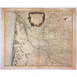
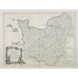
Normannia Galliae Celebris Provincia
A detailed map of the Normandy coast based on the cartography of Delisle. On the left side is a glimpse of the Atlantic Ocean. In the lower right is Chartres. In the uppe...
Date: Nuremberg, 1755
Selling price: ????
Please login to see price!
Sold in 2017
Artois Picardie.
Fine map of the French provinces of Picardy and Artois. George Louis Le Rouge was active from 1740- till 1780 as a publisher, and was appointed engineer for the King of F...
Date: Paris 1756
Selling price: ????
Please login to see price!
Sold
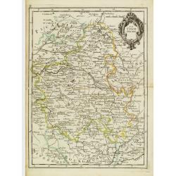
L'Isle de France.
Fine map of the French region Île de France whose chief town is Paris. It presents a decorative cartouche on lower right corner. George Louis Le Rouge was active from 17...
Date: Paris 1756
Selling price: ????
Please login to see price!
Sold
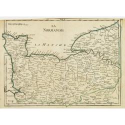
La Normandie.
Fine map of the French region Normandy. George Louis Le Rouge was active from 1740- till 1780 as a publisher, and was appointed engineer for the King of France. From his ...
Date: Paris 1756
Selling price: ????
Please login to see price!
Sold
La Champagne.
Fine map of the French region Champagne, with decorative title cartouche. George Louis Le Rouge was active from 1740- till 1780 as a publisher, and was appointed engineer...
Date: Paris 1756
Selling price: ????
Please login to see price!
Sold
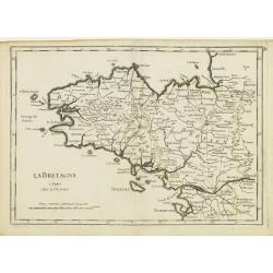
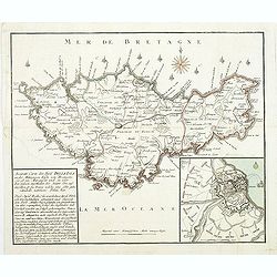
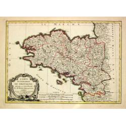
La Bretagne.
Fine map of the French region Brittany. George Louis Le Rouge was active from 1740- till 1780 as a publisher, and was appointed engineer for the King of France. From his ...
Date: Paris 1756
Selling price: ????
Please login to see price!
Sold
Orleanois, Perche, le Mans, Anjou, Tourraine, Berry.
Fine map of today's French region called Centre, including the towns of Orleans, Tours and Bourges. With decorative title cartouche. George Louis Le Rouge was active from...
Date: Paris 1756
Selling price: ????
Please login to see price!
Sold
Poitou, Saintonge, Angoumois.
Fine map of the today's French region Poitou-Charente, including part of the Vendée. George Louis Le Rouge was active from 1740- till 1780 as a publisher, and was appoin...
Date: Paris 1756
Selling price: ????
Please login to see price!
Sold
Bourbonnois, Marche, Limousin, Auvergne, Forez, Beaujolois.
Fine map of the today's French regions of Limousin and Auvergne, including part of the Rhône-Alpes region. George Louis Le Rouge was active from 1740- till 1780 as a pub...
Date: Paris 1756
Selling price: ????
Please login to see price!
Sold in 2010
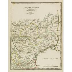
Languedoc, Roussillon, Foix, Quercy, et Rouergue.
Fine map of the French region Languedoc-Roussillon, including some territory at its East. George Louis Le Rouge was active from 1740- till 1780 as a publisher, and was ap...
Date: Paris 1756
Selling price: ????
Please login to see price!
Sold
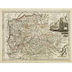
La Savoye.
Fine map of Savoy with decorative cartouches on right corners. George Louis Le Rouge was active from 1740- till 1780 as a publisher, and was appointed engineer for the Ki...
Date: Paris 1756
Selling price: ????
Please login to see price!
Sold
Carte de la Lorraine et du Barbois ....
Striking 1756 map of the French wine making region of Lorraine by Robert de Vaugondy. It covers the north east portion of France along with parts of neighboring Germany f...
Date: Paris , 1756
Selling price: ????
Please login to see price!
Sold in 2017
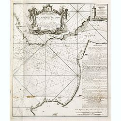
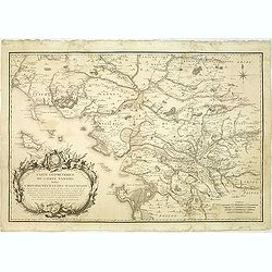
Carte géométrique de l'Entrée de la Rivière de Loire Représentée de Basse Mer dans les grandes Marées des Nouvelles et Pleines Lunes
Right hand part of a two sheet chart of the exit of the River Loire, prepared and published by Nicolas Magin (1663-1742). Engraved by Dheulland.
Date: Paris, 1757
Selling price: ????
Please login to see price!
Sold in 2015
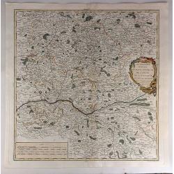
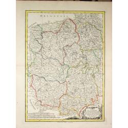
Gouvernement General D'Orleanois.
A beautiful 1753 de Vaugondy map of the Orleans Region in Central France. It covers from Corbeil-Essonnes south to Vatan in the north and from Tours east as far as Sens a...
Date: Paris, 1757
Selling price: ????
Please login to see price!
Sold in 2019
A Draught of the Road and Harbour of Brest with the Adjacent Coast
An interesting copper engraving map of France with rhumb lines and fleur-de-lys. Map extends from Le Counquet to Le Faou, detailing the coastline, anchorages and sounding...
Date: Paris, 1759
Selling price: ????
Please login to see price!
Sold in 2016
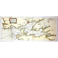
Carte De L'Isle De Belle-Isle..
Large-scale sea of Belle-Ile, in upper right corner inset of the French coast with Belle-Ile, îles de Quiberon with the bay of Morbihan. With rhumb lines.Published by t...
Date: Paris, 1761
Selling price: ????
Please login to see price!
Sold
Accurate Carte des insul BelleIsle an der Mittägien Küste von Bretagne. . .
Map of Belle Isle. In the lower left corner a descriptive text with a chronology of the siege and occupation of the island "Accurate Carte der INSUL BELLE ISLE [Bell...
Date: Nurnberg, 1761
Selling price: ????
Please login to see price!
Sold
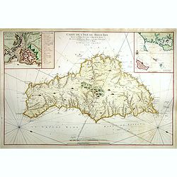
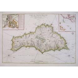
Carte De L'Isle De Belle-Isle. . .
Large-scale sea chart of Belle-Ile, in upper right corner inset of the French coast with Belle-Ile, îles de Quiberon with the bay of Morbihan. With rhumb lines.Published...
Date: Paris, 1761
Selling price: ????
Please login to see price!
Sold in 2018
Différentes Projections Des Cartes.
Decorative map of the region "Île de France".Left and right a box with technical information concerning the different types of maps and the methods used to con...
Date: Paris 1762
Selling price: ????
Please login to see price!
Sold
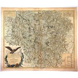
Propriae Lugudunensis Generalitatis Mappa Chorographica
A detailed map of the Beaujolais region, including the cities of Lyon, Clermont Ferrand, Roanne, Saint Etienne, and Vienne. Fully engraved with mountains, lakes, rivers, ...
Date: Nuremberg, 1762
Selling price: ????
Please login to see price!
Sold in 2016
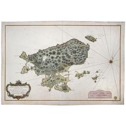
Saint Pierre, Plan de l'Ile de .., au Sud de Terre-Neuve.
A highly detailed map based on a survey by Fortin, and published by the 'Dépôt Général de la Marine' (the maritime chart printing office of the French government) in ...
Date: Paris, 1763
Selling price: ????
Please login to see price!
Sold in 2022
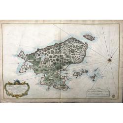
Plan de L'Ile de Saint Pierre au Sud de Terre-Neuve Levé en 1793 par le Sr. Fortin Ingénieur Géographe, et Publié au Dépôt Général des Cartes . . .
A very large, extremely decorative, detailed map of the island of St. Pierre, produced for the French 'Depot de la Marine'. kindly note the nice original colors.
Date: Paris, 1763
Selling price: ????
Please login to see price!
Sold in 2021
![Mt de Cette. [14]](/uploads/cache/12234-250x250.jpg)
Mt de Cette. [14]
Charming of the Mount of Cette. Showing town and harbor plan, with soundings, anchorages, rocks, shoals, fortifications, lighthouses.Joseph Roux (1725-1793) was a Marsei...
Date: Marseille 1764
Selling price: ????
Please login to see price!
Sold
![Grande Rade. [19]](/uploads/cache/12239-250x250.jpg)
Grande Rade. [19]
Charming of Grande Rade . Showing town and harbor plan, with soundings, anchorages, rocks, shoals, fortifications, lighthouses.Joseph Roux (1725-1793) was a Marseilles h...
Date: Marseille, 1764
Selling price: ????
Please login to see price!
Sold
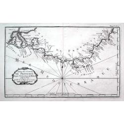
Carte des costes de Provence...
A detailed copper engraved map of Provence with the French Riviera, from the mouth of the Rhône, Arles and the Camargue to Nice. Including Marseille, Toulon, Saint-Trope...
Date: Paris, 1764
Selling price: ????
Please login to see price!
Sold in 2016
Collection of 9 eighteenth century maps including Paris, plus an attractive dedication page.
Taken from 'A MONSIEUR CASSINI DE THURY SEIGNIEUR DE VILLETANEUSE, Directeur de l'Observatoire Royal, Maitre des Comple[a] ASSOCIE Des Academies des Sciences de PARIS, LO...
Date: Paris, 1765
Selling price: ????
Please login to see price!
Sold in 2013
Carta Geographica del Governo della Normandie.
Engraved map of Normandy. The cartouche is remarkable and takes up more than one quarter of the space. Giambattista Albrizzi (1698-1777) was a Venetian publisher and jour...
Date: Venice, 1740-1765
Selling price: ????
Please login to see price!
Sold in 2013
Carta geografica del governo di Guienna e Guascogna.
Detailed map of the south west coast of FranceAn uncommon pirate edition of the map originally published by Isaac Tirion. Taken from "Storia moderna di tutti I popol...
Date: Venice, 1740-1765
Selling price: ????
Please login to see price!
Sold
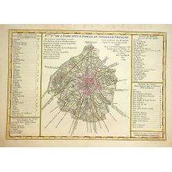
Nouv.lle Election et Environs de Paris très détaillés. . .
Charming small map centered on Paris, depicting a large area around the capital. Small title cartouche and scale cartouche in the upper corners.From the second edition of...
Date: Paris, 1766
Selling price: ????
Please login to see price!
Sold
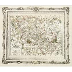
Election de Beauvais.
Charming small map depicting the area around Beauvais. Surrounded by a decorative frame embellished with floral patterns. From the second edition of the rare Atlas chorog...
Date: Paris, 1766
Selling price: ????
Please login to see price!
Sold
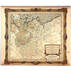
Cercles de Haute et Basse Saxe...
A decorative map of northern Germany with a fine title cartouche. The map is surrounded by a wide rococo-style frame. The map and decorative border were printed from two ...
Date: Paris, 1766
Selling price: ????
Please login to see price!
Sold in 2016
Carte géométrique du comté nantois dédiée à Monseigneur le duc d'Aiguillon par Ogée, sous-ingénieur des Ponts et Chaussées au comté de Nantes.
Very rare map of the Brittany coast with Belle Isle and the regions of Vannes, Nantes. In upper left the Morbian Bay. The map is engraved by P. N. Le Roy, who was a ingen...
Date: Paris, 1768
Selling price: ????
Please login to see price!
Sold
Nieuwe kaart van het Zuidelykste Gedeelte van Frankryk.
Izaak Tirion (d. 1769) Amsterdam publisher. His ' Nieuwe en beknopte handatlas' saw 6 editions between before 1740 and after 1784. Also ' Tegenwoordige staat van alle vol...
Date: Amsterdam, c. 1770
Selling price: ????
Please login to see price!
Sold
Partie Septentrionale du Duche de Bourgogne.
Map showing the Burgundy region of France. The cities of Auxonne and Dijon are shown in the lower right, Auxerre in the upper left and Chaumont in the upper right.
Date: Augsburg, 1770
Selling price: ????
Please login to see price!
Sold in 2010
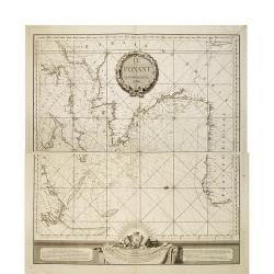
Le Ponant.
in two sheets. The chart depicts the Channel, including a detailed rendering of the south coast of England, the west coast of France and the north coast of Spain, includ...
Date: Le Havre, J.B. Patry, 1772
Selling price: ????
Please login to see price!
Sold in 2010
XVIII Fle L'indicateur fidele du voyageur François.
Fine post road mapsroad map of the Provence from "L'Indicateur fidèle ou guide des voyageurs, qui enseigne toutes les routes royales et particulières de la France,...
Date: Paris, 1772
Selling price: ????
Please login to see price!
Sold
Carte des environs de Paris, suivant les nouvelles observations par J. Laurent,...
Highly detailed map of Paris and environs printed by Mondhare. Includes many small villages which are now actually within the Paris city limits... Extends from Vernon an...
Date: Paris, 1773
Selling price: ????
Please login to see price!
Sold in 2013
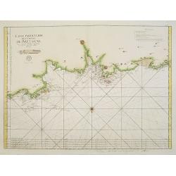
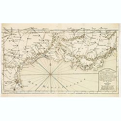
3. Carte Particuliere Des Costes De Bretagne Qui comprend Morlaix Saint Paul de Leon les Sept Isles et l'Isle de Bas..
Large-scale sea chart covering the French coast Brittany.With compass rose, rhumb lines and distance scale.Published by the Depot Générale de la marine with stamp and P...
Date: Paris, c.1773
Selling price: ????
Please login to see price!
Sold
Li Governi di Guyenna e Guascogna con quello di Bearn e Bassa Navarra
Map of the Bourdeaux region of France, including the cities of Bourdeaux, Marmande, Tonneins, and Bayonne. To the south, the Navarra region of Spain along with the Pyrene...
Date: Venice, 1776
Selling price: ????
Please login to see price!
Sold in 2010
Li Governi del Limosin, Quercy, E Preigord Di Nuoca Projezione.
Map of the regions Limousin, Quercy and Périgord in southwest France different colors are used to outline the three regions and the titles in bold lettering further dist...
Date: Venice, 1776
Selling price: ????
Please login to see price!
Sold in 2010
Li Governi del Berri, del Nivernois, della Marche, del Bourbonnois e dell \'Auvergne Di Nvoua Projezione.
Map of five regions in central France including the province Berry, most famous for the 14-15th century illuminated manuscript, "Les Trés Riches Heures du Dec de Be...
Date: Venice, 1776
Selling price: ????
Please login to see price!
Sold in 2010
Li Governi Di Lorenza, Barr, ed Alsazia Di Nuova Projecione.
Map of three regions in northeastern France: Barrois, Lorraine and Alsace. Barrois is a "pays" and in the Middle Ages the region was a part of the duchy of Bar....
Date: Venice, 1776
Selling price: ????
Please login to see price!
Sold in 2010
Li Governi dell\'Isola Di Francia ED Orleanois Di Nuova Projezione.
Map of the region surrounding Orleans France by Antonio Zatta. Map includes major cites such as Chartres, Fontainebleau and Beauvais and rivers systems. A bold cartouche ...
Date: Venice, 1776
Selling price: ????
Please login to see price!
Sold in 2010
Li Governi della Fiandra Francese, d\'Artois, di Picardia, del Boulonois di Nuova Projezione.
Map of Northern France by Antonio Zatta. This wonderfully detailed composition includes major cites such as Calais, Abbeville, and Dunkirk, and the northern coastline of ...
Date: Venice, 1776
Selling price: ????
Please login to see price!
Sold in 2010
Li Governi di Normandia del Maine e Perche di Nuova Projezione.
Map of the Normandy Coast of France by Antonio Zatta. This detailed map depicts major cities such as Rouen, Ambriere and Mortagne, and the off coast islands of Jersey, Gu...
Date: Venice, 1776
Selling price: ????
Please login to see price!
Sold in 2010
Carte du Gouvernement de Champagne et Brie
This large, very detailed, copper engraved map of French provinces is based on the earlier map by Bonne. It shows forests, cities, towns, mountains and roads and is decor...
Date: Venice, 1776
Selling price: ????
Please login to see price!
Sold in 2014
Li Governi di Guyenne e guascogna con quello de Bearn e Bassa Navarra. . .
A map of the Bordeaux region of France, including the cities of Bordeaux, Marmande, Tonneins, and Bayonne. To the south, the Navarra region of Spain along with the Pyrene...
Date: Venice, 1776
Selling price: ????
Please login to see price!
Sold in 2021
Carte du Gouvernement de Normandie avec celui du Maine et Perche projettée et assujettie aux observat. À Paris par M. Bonne Mtre Mathémat. À Paris 1771.
A general map of Normandy, Maine and Perche describing these different regions. Published by P. Santini map, an Italian map publisher who worked in Venice. Notable works...
Date: Venice, 1777
Selling price: ????
Please login to see price!
Sold
Li Governi Di Sciampagna E Brie Di Nuiva Projezione
This map of France highlights the Champagne and Brie regions in the northeastern part of the country. Each of these cities derives their names from the sparkling wine and...
Date: Venice, 1777
Selling price: ????
Please login to see price!
Sold in 2010
Carte dy Gouvernement de L'Isle de France et de L'Orleanois
A large, beautiful map of France's most populous province, centered around Paris. It is decorated by a large title cartouche. Francois [Francesco] Santini was a Venetian...
Date: Venice, 1777
Selling price: ????
Please login to see price!
Sold in 2014
Carte des Gouvernements D'Anjou et du Saumurois.
A beautiful example of Rigobert Bonne's decorative map of the famous French "Chateau" wine-making region, hugging the Loire Valley. It was included in Santini's...
Date: Venice, 1777
Selling price: ????
Please login to see price!
Sold in 2015
Carte du Gouvernement de Guienne et Gascogne avec Celui de Bearn et Basse Navarre.
Striking Venetian edition of a copper engraved map of Guyenne and Gascogne in southwestern France, the home of Armagnac and Foie Gras. Bonne created the map. Francois or ...
Date: Vienna, 1777
Selling price: ????
Please login to see price!
Sold in 2014
Carte des Gouvernements de Languedoc, de Foix et de Roussillon.
Striking large copper engraved map of the governments of Languedoc, Roussiloon de Foix and eastern Guienne. Lovely colorful floral title cartouche. Francois or Paolo Sa...
Date: Vienna, 1777
Selling price: ????
Please login to see price!
Sold in 2013
Carte des Gouvernements du Berri, du Nivernois, de la Marche, du Bourbonnois, du Limosin et de L'Auvergne.
Striking large map of central France including Limoges, Moulins. It was based on a smaller map by R. Bonne in 1771. It features a Rococco cartouche. Francois or Paolo San...
Date: Venice, 1777
Selling price: ????
Please login to see price!
Sold in 2016
Carte des Gouvernements de Bourgogne, de Franche Comte et de Lyonnois.
Impressive large map of French provinces, including Lyon, Dijon, and Besancon, and the border with Switzerland. It was based on a smaller map by Bonne in 1771. It feature...
Date: Venice, 1777
Selling price: ????
Please login to see price!
Sold in 2014

Li Governi di Normandia del Maine e Perche.
A pleasant map shows all of Normandie with its islands: Maine in the french province of Pays de la Loire and Berche in the region of Bourgogne-Franche-Comté. Features a...
Date: Venice, 1777
Selling price: ????
Please login to see price!
Sold in 2023
Duche de Savoye qui comprend le Chablais, le Fossigny, Le Genevois...
Fine map of the area, extending from Lake Geneva southwards, including Aosta, Aix-les-Bains, Chambéry, Annecy, Chamonix, etc. Very nice depiction of the mountains and va...
Date: Venice, 1778
Selling price: ????
Please login to see price!
Sold in 2012
Carte du Bearn de la Bigorre de l'Armagnac..
Map of south-west part of France covering the Landes country with Dax, Bayonne and Pau till Montauban and Toulouse on the right.
Date: Paris, ca. 1780
Selling price: ????
Please login to see price!
Sold
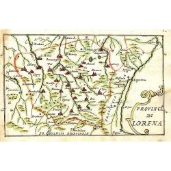
Provincia di Lorena.
Scarce manuscript map of the Lorraine region. Includes the cities of Metz, Verdun, Nancy,... Finely executed and detailed map by an Italian hand, showing the cities repre...
Date: 1740-1780
Selling price: ????
Please login to see price!
Sold in 2009
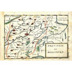
Provincia di Borgogna.
Rare manuscript map of the French border to Switzerland. Centered on Besancon, including the Lake de Geneva in Switzerland. Finely executed and detailed map by an Italia...
Date: c. 1740-1780
Selling price: ????
Please login to see price!
Sold in 2013
Montlouis.
Montlouis (Languedoc-Roussillon).
Date: Paris, ca. 1780
Selling price: ????
Please login to see price!
Sold in 2011
Les Généralitez de Montauban et de Toulouse . . .
Detailed map of the southwest of France, including the towns of Carcassonne, Perpignan, including the Royal Canal.Avec Privilège du Roy.
Date: Paris, 1781
Selling price: ????
Please login to see price!
Sold
Carte des Gouvernements de Dauphine et de Provence.
Jean Lattré, Paris-based engraver and publisher. Worked with Robert de Vaugondy, J. Janvier and R. Bonne. " Atlas Monderne', 1771, 1783 , 1793. Rigobert Bonne (1727...
Date: Paris, 1783
Selling price: ????
Please login to see price!
Sold
Carte des Gouvernements du Berri, du Nivernois, de la Marche, du Bourbonnois, du Limosin et de l\' Auvergne.
Jean Lattré, Paris-based engraver and publisher. Worked with Robert de Vaugondy, J. Janvier and R. Bonne. " Atlas Monderne', 1771, 1783 , 1793. Rigobert Bonne (1727...
Date: Paris, 1783
Selling price: ????
Please login to see price!
Sold in 2014
Carte du Gouvernement de Bretagne.
Jean Lattré, Paris-based engraver and publisher. Worked with Robert de Vaugondy, J. Janvier and R. Bonne. " Atlas Monderne', 1771, 1783 , 1793. Rigobert Bonne (1727...
Date: Paris, 1783
Selling price: ????
Please login to see price!
Sold
Carte des Gouvernements de Languedoc, de Foix et de Rousillon avec la Partie Oreintale du Gouvernement de Guienne.
Jean Lattré, Paris-based engraver and publisher. Worked with Robert de Vaugondy, J. Janvier and R. Bonne. " Atlas Monderne', 1771, 1783 , 1793. Rigobert Bonne (1727...
Date: Paris, 1783
Selling price: ????
Please login to see price!
Sold
