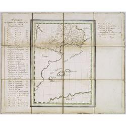
Browse Listings in Europe > France > France Provinces
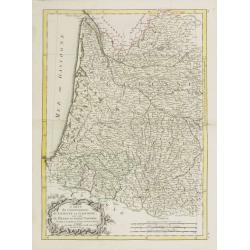
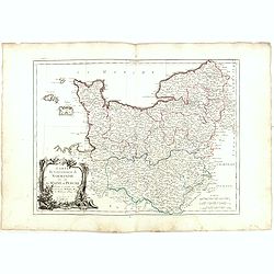
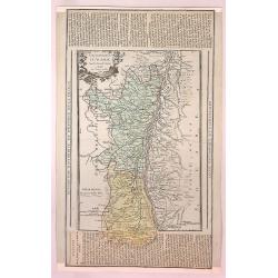
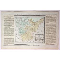
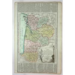
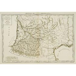
Carte du Gouvernement de Guienne et Gascogne.. Navarre..
Attractive map of the south western part of France delimited by the Garonneoutfall, the town of Toulouse and the Pyrenees.Decorated with a rococo title cartouche. Boundar...
Date: Paris, ca 1783
Selling price: ????
Please login to see price!
Sold
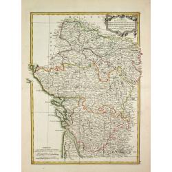
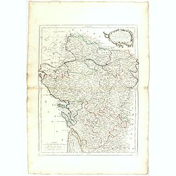
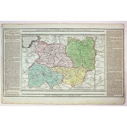
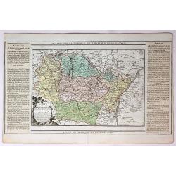
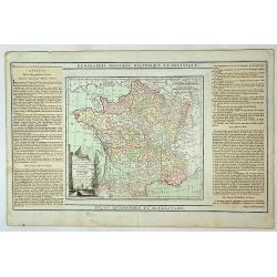
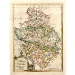
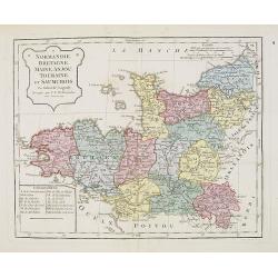
Carte des Gouvernements de d' Anjou, et du Saumurois, de la Touraine, du Poitot, du Pays d' Aunis, Saintonge-Angoumois.
Jean Lattré, Paris-based engraver and publisher. Worked with Robert de Vaugondy, J. Janvier and R. Bonne. " Atlas Monderne', 1771, 1783 , 1793. Rigobert Bonne (1727...
Date: Paris, 1783
Selling price: ????
Please login to see price!
Sold in 2009
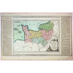
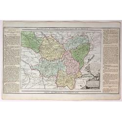
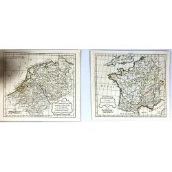
![[4 maps] Carte du Gouvernement de Bretagne . . . / Carte du Gouvernement de l'Isle de France . . . / Carte des Gouvernements de Flandre Françoise, / Carte du Gouvernement de Normandie...](/uploads/cache/42824-250x250.jpg)
[4 maps] Carte du Gouvernement de Bretagne . . . / Carte du Gouvernement de l'Isle de France . . . / Carte des Gouvernements de Flandre Françoise, / Carte du Gouvernement de Normandie...
Four attractive maps of French provinces, ornated with a decorative title cartouche. Boundaries outlined in hand color.Prepared by Le Sieur Janvier, Jean Denis [Robert], ...
Date: Paris, ca 1783
Selling price: ????
Please login to see price!
Sold in 2020
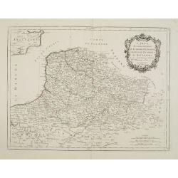
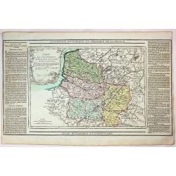
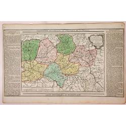
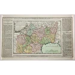
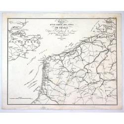
Gouvernements de Flandre Françoise, d'Artois, de Picardie..
Detailed map encompassing northwestern part of France, with the Channel and tip of southern England.Venetian edition of the map by Bellin, to whom Santini gives credit in...
Date: Venice, 1776 - 1784
Selling price: ????
Please login to see price!
Sold in 2008
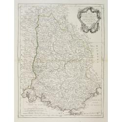
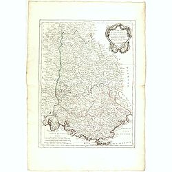
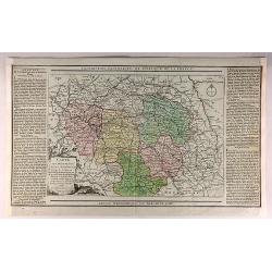
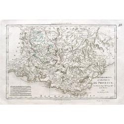
Carte des Gouvernements de Dauphiné et de Province. . .
Attractive map of part of France, covering the eastern part of the Gulf of Lyon with its hinterland. Extending as far as Nice and Grenoble.Decorated with a rococo title c...
Date: Venice, 1777 - 1784
Selling price: ????
Please login to see price!
Sold
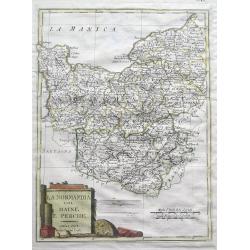
Carte du Gouvernement de Normandie avec celui du Maine et Perche.
Map of Normandy, with ornate title cartouche in lower left bottom. With ornamental title cartouche and noteworthy topographical detail.The map was prepared by the Venetia...
Date: Venice, 1776 - 1784
Selling price: ????
Please login to see price!
Sold
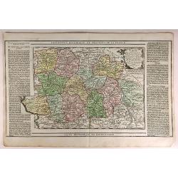
Carte des Gouverneménts d'Anjou et du Saumurois, de la Touraine, du Poitou, du Pays d'Aunis Saintonge - Angoumois. . .
Attractive map of the south western part of France, including isle de Ré and Isle d'Oleron. The map was prepared by R. Bonne, who is given credit in the title cartouche....
Date: Venice, 1777 - 1784
Selling price: ????
Please login to see price!
Sold in 2015
Carte des Gouvernements de Dauphiné et de Province. . .
Attractive map of part of France, covering the eastern part of the Gulf of Lyon with its hinterland. Extending as far as Nice and Grenoble. With ornamental title cartouch...
Date: Venice, 1777 - 1784
Selling price: ????
Please login to see price!
Sold

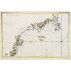
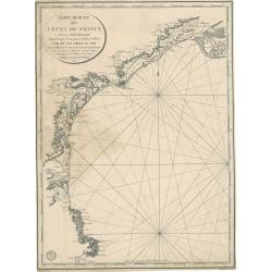
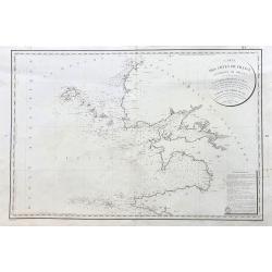
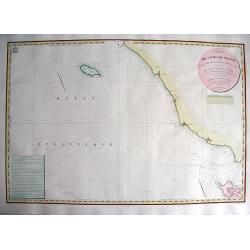
Carte Réduite du Golphe de Gascogne. . .
Uncommon chart of the coast of Gascoigne from Brest in Brittany up to Santander in Spain.
Date: Paris, 1756 - 1784
Selling price: ????
Please login to see price!
Sold in 2018
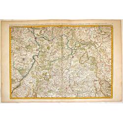
Partie du Palatinat du Rhein, le Duché de Wirtenberg les Partie du Palatinat du Rhein. Le Duche de Wirtenberg, Les Marquisats de Bade & Durlac, les Eveschés de Worms de Spire et le Comté de Linange.
Large, hand-colored, copperplate map of Rhineland Germany. It features the cities of Manheim, Hailbron, Stuttgart, Heidelberg & Baden. very detailed showing individua...
Date: Paris, 1785
Selling price: ????
Please login to see price!
Sold in 2016
Gouvernement D'Alsace avec les Grandes Routes.
An attractive and informative map of Alsace by French cartographer, Louis Brion de la Tour. It notes numerous towns, cities, rivers, forests, mountains and other topograp...
Date: Paris, 1786
Selling price: ????
Please login to see price!
Sold in 2018
Carte des Departemens du Puy de Dome, du Cantel, du Rhone et Loire et de la Haute Loire.
This is a striking 1786 Desnos and Brion map of France showing four departments. To the left and right of the map are paste downs of French text with remarks and descript...
Date: Paris, 1786
Selling price: ????
Please login to see price!
Sold in 2018
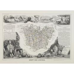
Carte des Departemensde la Manche, du Calvados de L'Orne, de L'Eure et de la Seine Inferieure.
This is a striking 1786 Desnos and Brion map of France showing five French departments. To the left and right of the map are paste downs of French text with remarks and d...
Date: Paris, 1786
Selling price: ????
Please login to see price!
Sold in 2017
Carte des Deppartemens du Pas de Calais, de la Somme et de L'Oise dt de L'Aisne.
This is a striking 1786 Desnos and Brion map of three administrative divisions listed above. To the left and right of the map are paste downs of French text with remarks ...
Date: Paris, 1786
Selling price: ????
Please login to see price!
Sold in 2019
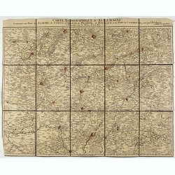
Carte Topographque D'Allemagne / Contenant une partie de Flandre, du Comté d'Artois, de Picardie, du Haynaut et le Pais de Cambresis.
Folding map of Northern France with part of Flanders, the County of Artois, Picardy, the Haynaut and Cambray, published by the German Military cartographer Johann Wilhelm...
Date: Frankfurt, 1787
Selling price: ????
Please login to see price!
Sold in 2021
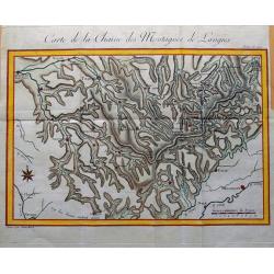
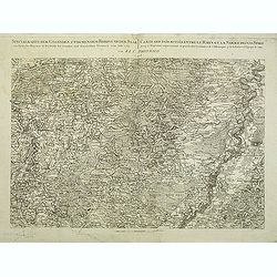
Carte de la Chaine des Montagnes de Langres.
Unusual map an area in North-East France, including the cities of Sens, Troyes, Bar-sur-Aube, Chaumont, Neufchateau, Langres, Gray, Besancon, Dijon, Auxerre. Great detail...
Date: Paris, c1790
Selling price: ????
Please login to see price!
Sold in 2015
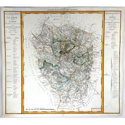
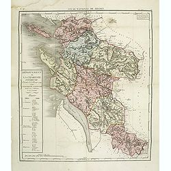
Departement de Paris & Departement de la Seine et de la L'Oise
A fine map featuring the area of France surrounding Paris. From the "Atlas National de France" by Pierre Dumez (1757-1794). The map has a detailed index on both...
Date: Paris, 1790
Selling price: ????
Please login to see price!
Sold in 2016
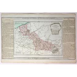
Carte du Departement du Nord.
An attractive map of the department of Nord in northern France by French cartographer, Louis Brion de la Tour. It notes numerous towns, cities, rivers, forests, mountains...
Date: Paris, 1790
Selling price: ????
Please login to see price!
Sold in 2017
Cercles de Haute wt Basse Saxe,Divises en Toutes Leurs Principantes et Provinces...
An attractive and informative map of France by French cartographer, Louis Brion de la Tour. It notes numerous towns, cities, rivers, forests, mountains and other topograp...
Date: Paris, 1790
Selling price: ????
Please login to see price!
Sold in 2019
Carte des Departemens de la Meuse, de la Moselle, de la Meurte, des Voges et du Bas Rhin...
An attractive and informative map of departments in France by French cartographer, Louis Brion de la Tour. It notes numerous towns, cities, rivers, forests, mountains and...
Date: Paris, 1790
Selling price: ????
Please login to see price!
Sold in 2018
Carte des Departemens de la Cote d'Or, de Daone et Loire, de la HauteSaone, du Doubs de Jura.....
An attractive and informative map of French departments by French cartographer, Louis Brion de la Tour. It notes numerous towns, cities, rivers, forests, mountains and ot...
Date: Paris, 1790
Selling price: ????
Please login to see price!
Sold in 2019
Carte des Departemens de la Mayenne, de la Sarte, D'Eure et Loire, de maine et Loire, d'Indre et de Loire....
An attractive and informative map of several provinces by French cartographer Louis Brion de la Tour. It notes numerous towns, cities, rivers, forests, mountains, and oth...
Date: Paris, 1790
Selling price: ????
Please login to see price!
Sold in 2019
Carte des Departemens de la Charente Inferieure, de la Charente, de la Gironde, de la Dordogne, des Landes, du Lot et Garonne et des Baffes Pyrenees...
An attractive and informative map several French Provinces by French cartographer, Louis Brion de la Tour. It notes numerous towns, cities, rivers, forests, mountains an...
Date: Paris, 1790
Selling price: ????
Please login to see price!
Sold in 2019
La France Divisee en ses Quarante Gouvernemens Generaux et Militaires...
An attractive and informative map of the governmental and military parts of France by French cartographer, Louis Brion de la Tour. It notes numerous towns, cities, rivers...
Date: Paris, 1790
Selling price: ????
Please login to see price!
Sold in 2018
Carte des Departemens de Paris, de la Seine et de l'Oise de la Marne.
A striking 1790 map featuring parts of the Ile-de-France, Champagne-Ardenne and Bourgogne regions of France, including Paris, by the French cartographer Louis Brion de la...
Date: Paris, 1790
Selling price: ????
Please login to see price!
Sold in 2018
Carte des Departemens de la Mayenne, de la Sarte, de Maine et Loire, D'indre et Loir...
This is a lovely 1790 map of the Pays de la Loire, Center, Poitou-Charentes, and Bourgogne regions of France by the French cartographer Louis Brion de la Tour. It covers ...
Date: Paris, 1790
Selling price: ????
Please login to see price!
Sold in 2019
Départements et districts de Provence.
An excellent map of the Provence from Nimes until Monaco,
Date: Paris, ca. 1790
Selling price: ????
Please login to see price!
Sold in 2018
Description Historique et Politique de la France.
A map of the departments of Lot, Aveyron, Lozere, Ardeche, Gers, Garonne, Tarn, Herault, Gard, Htes Pyrenees, Ariège and Aude by Brion, the engineer geographer of the ki...
Date: Paris, 1790
Selling price: ????
Please login to see price!
Sold in 2018
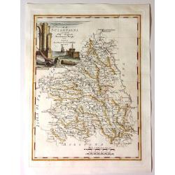
La Scampagna.
Fine map of “La Sciampagna" (Champagne) by Bartolammeo Borghi. Edited by Vincenzo Pazzini Carli and is from the atlas "Atlante Novissimo".Striking cartou...
Date: Sienna, 1791
Selling price: ????
Please login to see price!
Sold in 2021
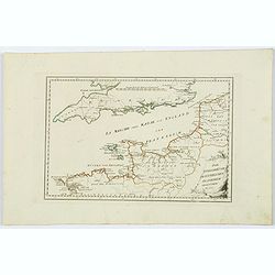
Die Englischekuste dem Nordlichen Frankreich.
Von Reilly's map of the English Channel, the Channel Islands, southern England and northern France. From the Atlas Schauplatz der funf Theile der Welt. With some coastal ...
Date: Vienna, 1791
Selling price: ????
Please login to see price!
Sold in 2021
Côtes de France : Département du Var, comprenant le Golfe de la Napoule et le Gourjean. . .
Uncommon of part of the French Mediterranean seaboard centered on the Îles de Lérins and La Napoule gulf with Cannes and Nice. It covers the coast extending from the a...
Date: Paris, 1792
Selling price: ????
Please login to see price!
Sold in 2011
L'Anjou il Saumurois Il Poitou L'Aunis La Saintonge e L'Angoumois.
Copper engraving from the rare Geographical Atlas published in Siena by Pazzini Carli between 1798 and 1800, which can be considered a sort of dress rehearsal for the mos...
Date: Florence, 1792
Selling price: ????
Please login to see price!
Sold in 2017
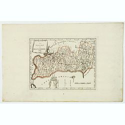
Normandia col Maine e Perche.
Unusual Italian map of Normandy - from Cherbourg to Le Tréport in the north and extending until Chartres, Laval, and Le Mans. With a large decorative title cartouche and...
Date: Siena, 1792
Selling price: ????
Please login to see price!
Sold in 2016
(2 Maps) La Gaule & Partie de L'Empire Francais Royaumes de Hollande, de Westphalie, grand duche de Berg
Two maps of France at different times during their history. They are by Delamarche, the successor of Robert de Vaugondy.
Date: Paris, 1794
Selling price: ????
Please login to see price!
Sold in 2017
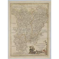
La Borgogna Franca Contea E Lionese.
A pleasant map of the Borgogna, Franca Contea and Lionese regions of France, by Carli Pazzini in Sienna in 1794. The map features a cartouche with a peasant leading cattl...
Date: Siena, 1794
Selling price: ????
Please login to see price!
Sold in 2019
Das Departement des Canals La Manche.
Manche is one of the original 83 departments created during the French Revolution on March 4, 1790. It was created from part of the province of Normandie. The first capit...
Date: Vienna, ca 1795
Selling price: ????
Please login to see price!
Sold in 2021
Specialkarte der Gegenden zwischen dem Rhein und der Saar. . . / Carte des pais situes entre le rhin et la sarre depuis spire. . .
Map of the frontier between Germany and France. Beautiful map showing the relief. Engraved by B.F. Leizelt.
Date: Augsburg, 1798
Selling price: ????
Please login to see price!
Sold in 2014
Gouvernements de Lorraine et Des Trois Eveches.
A large, detailed copper engraving map of the province of Lorraine, France by Mentelle and Chanlaire, from their "Atlas Universel". Published in Paris in 1798.
Date: Paris, 1798
Selling price: ????
Please login to see price!
Sold in 2018
Normandie, Bretagne, Maine, Anjou, Tourraine, et Saumurois.
Map of Normandy, Brittany, Maine, Anjou, Tourraine, and the Saumur region. By C. F. Delamarche, successor of Robert de Vaugondy, Geographer. Inset lower left corner of t...
Date: Paris, 1794 - 1806
Selling price: ????
Please login to see price!
Sold in 2008
Carte des Rivieres et Ruisseaux du Bassin de la Seine, qui servent a l'Approvisionnement de Paris.
Map of rivers and streams of the Seine basin that supply Paris, France , divided into departments indicating the offices of supply. The map was dedicated to Commissioner ...
Date: Paris, ca. 1810
Selling price: ????
Please login to see price!
Sold in 2023
Carte réduite des côtes de France sur la Méditerranée
This masterful and attractive sea chart of the southern coast of France was created by order of the King of France for the Royal Nautical Depository (Dépôt), and bears ...
Date: Paris, 1817
Selling price: ????
Please login to see price!
Sold in 2023
Departement de la Seine et de l'Oise.
Detailed map centered on Paris. Taken from "Atlas national de France", the first atlas with the departments of France published by Pierre Grégoire Chanlaire.
Date: Paris, P.G. Chanlaire, 1818
Selling price: ????
Please login to see price!
Sold
Département de la Charente inférieure decreté le 6 février 1790. . .
Map of region of west of France. Region of Charente inférieure divided into 7 districts. explicative text with the division of the districts and cantons.Sheet No. 38 fro...
Date: Paris, 1790-1818
Selling price: ????
Please login to see price!
Sold
![Untitled. [Villefranche-sur-Mer]](/uploads/cache/90633-250x250.jpg)
Untitled. [Villefranche-sur-Mer]
Rare manuscript map of Villefranche-sur-Mer near Nice in southern France. Includes Mont Boron (here called Monboroni) and the peninsula of Saint-Jean-Cap-Ferrat. Finely e...
Date: France, 1819
Selling price: ????
Please login to see price!
Sold in 2008
Carte de la Guienne, de la Navarre et du Bérn.
A detailed map of Guienne and Gascoigne. Engraved by Vallet.
Date: Paris, 1820
Selling price: ????
Please login to see price!
Sold
Carte D'Une Partie des Cotes de France.
Minimally detailed map of northern France and southeast Britain by Ambrose Tardieu from:"Precis des Evenements Militaires de plans et de Cartes". It shows Franc...
Date: Paris , 1820
Selling price: ????
Please login to see price!
Sold in 2017
Carte des Cotes de France (environs de Brest) levee en 1816 1817 et 1818
A large sea-chart of the western parts of Finistère in the Bretagne, showing Ouessant, Brest, Plouguerneau, Crozon, Ile de Sein, and Audierne. With fantastic detail ...
Date: Paris, 1823
Selling price: ????
Please login to see price!
Sold in 2023
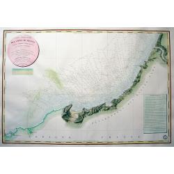
CARTE DES CÔTES DE FRANCE PARTIE COMPRISE ENTRE BAYONNE ET LA CÒTE D'ESPAGNE...
Highly decorative and scarce large-scale engraved seachart of the French and Spanish region at the Bay of Biscay / Coasts of Cantabria. Drawn by Besancon, engraved by Mic...
Date: Paris, 1829
Selling price: ????
Please login to see price!
Sold in 2010
CARTE DES CÔTES DE FRANCE PARTIE COMPRISE ENTRE L'ILE D'YEU ET LA POINTE DES BALEINES
Highly decorative and very rare large-scale engraved seachart of the French coast from Ile de Ré until Ile d'Yeu, engraved by Collin. Includes Jard, Les Sables D'Olonne,...
Date: Paris, 1832
Selling price: ????
Please login to see price!
Sold in 2010
Departement de Seine et Marne. . .
Map centred of Rosoy and Fontainebleau. Borders of the district are colored. Map showing the city Nemours, Melun, Meaux, etc. In the left margin a cartouche with the list...
Date: Paris, 1832
Selling price: ????
Please login to see price!
Sold
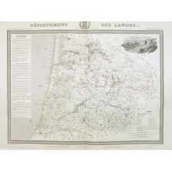
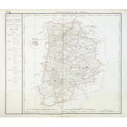
Département des Landes.
Detailed map of the Landes, with Bayonne in lower left corner. A panoramic view of Mont-de-Marsan upper right.. Text column of a detailed description of the geography, hi...
Date: Paris, 1844
Selling price: ????
Please login to see price!
Sold
Manuscript map of the Southern Provinces of France.
Very detailed manuscript folding-map of the southern part of France. Including Lyon, Nice, Marseilles, Toulouse.Including the Balearic Islands of Majorca, Minorca, Ibiza....
Date: France ca. 1850
Selling price: ????
Please login to see price!
Sold in 2020
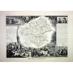
Lot of 4 French Departements
Four very decorative engraved maps of the French Departements: Haut Rhin, Loire, Lozère, Doubs. Ornately decorated borders, vignette scenes, portraits and views of the r...
Date: Paris, 1850
Selling price: ????
Please login to see price!
Sold
![Dépt. Des Bes. Du Rhône. N°12. [ Marseille, Arles, Aix ]](/uploads/cache/27091-250x250.jpg)
Dépt. Des Bes. Du Rhône. N°12. [ Marseille, Arles, Aix ]
Map of the region around Marseille, Arles, Aix in the south of France.Lovely map from one of the last decorative atlases of the nineteenth century.The rather simple map i...
Date: Paris, A. Combette, 1852
Selling price: ????
Please login to see price!
Sold in 2010
![Dépt. De La Charente. N°13. [ Cognac ]](/uploads/cache/27094-250x250.jpg)
Dépt. De La Charente. N°13. [ Cognac ]
Map of the Charente region, centered on Angouleme and Cognac. Home of the world's best-known brandy, the map shows the countryside surrounding the Charente River one hund...
Date: Paris, A. Combette, 1852
Selling price: ????
Please login to see price!
Sold in 2023
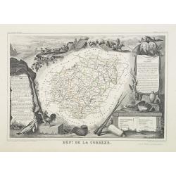
Dépt. De La Corrèze. N°18.
Map of the Corrèze region in France.Lovely map from one of the last decorative atlases of the nineteenth century.The rather simple map is framed by medallion portraits a...
Date: Paris, A. Combette, 1852
Selling price: ????
Please login to see price!
Sold in 2009
![Dépt. De La Côte D'Or. N°20. [ Lyon ]](/uploads/cache/27099-250x250.jpg)
Dépt. De La Côte D'Or. N°20. [ Lyon ]
Map of the Burgundy area, centered on Lyon.Lovely map from one of the last decorative atlases of the nineteenth century.The rather simple map is framed by medallion portr...
Date: Paris, A. Combette, 1852
Selling price: ????
Please login to see price!
Sold in 2009
![Dépt. Des Côtes Du Nord. N°21. [ St.Brieuc and St.Malo ]](/uploads/cache/27100-250x250.jpg)
Dépt. Des Côtes Du Nord. N°21. [ St.Brieuc and St.Malo ]
Map of the northern part of Brittany, including the towns of St.Brieuc and St.Malo, Dinan, etc.Lovely map from one of the last decorative atlases of the nineteenth centur...
Date: Paris, A. Combette, 1852
Selling price: ????
Please login to see price!
Sold
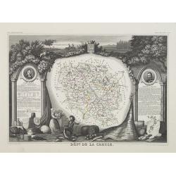
Dépt. De La Creuse. N°22.
Map of the Creuse region in France.Lovely map from one of the last decorative atlases of the nineteenth century.The rather simple map is framed by medallion portraits and...
Date: Paris, A. Combette, 1852
Selling price: ????
Please login to see price!
Sold in 2009
![Dépt. Du Doubs. N°24. [ Besançon ]](/uploads/cache/27103-250x250.jpg)
Dépt. Du Doubs. N°24. [ Besançon ]
Map of the Doubs region, centered on the town Besançon in France.Lovely map from one of the last decorative atlases of the nineteenth century.The rather simple map is fr...
Date: Paris, A. Combette, 1852
Selling price: ????
Please login to see price!
Sold in 2009
![Dépt. De La Dordogne. N°25. [ Perigueux ]](/uploads/cache/27104-250x250.jpg)
Dépt. De La Dordogne. N°25. [ Perigueux ]
Map of the Dordogne region, centered on Perigueux in France.Lovely map from one of the last decorative atlases of the nineteenth century.The rather simple map is framed b...
Date: Paris, A. Combette, 1852
Selling price: ????
Please login to see price!
Sold in 2010
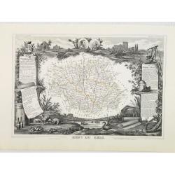
Dépt. De L'Eure. N°26.
Map of the Eure a region in France, including the area south of the River Seine from Vernon to Le Havre.Lovely map from one of the last decorative atlases of the nineteen...
Date: Paris, A. Combette, 1852
Selling price: ????
Please login to see price!
Sold in 2009
Dépt. Du Gers. N°31.
Map of the Gers region in France.Lovely map from one of the last decorative atlases of the nineteenth century.The rather simple map is framed by medallion portraits and c...
Date: Paris, A. Combette, 1852
Selling price: ????
Please login to see price!
Sold in 2010
![Dépt. De La Gironde. N°32. [ Bordeaux ]](/uploads/cache/27111-250x250.jpg)
Dépt. De La Gironde. N°32. [ Bordeaux ]
Map of the Gironde region, including Bordeaux in France.Lovely map from one of the last decorative atlases of the nineteenth century.The rather simple map is framed by me...
Date: Paris, A. Combette, 1852
Selling price: ????
Please login to see price!
Sold in 2009
![Dépt. De L'Hérault. N°33. [ Narbonne, Montpellier ]](/uploads/cache/27112-250x250.jpg)
Dépt. De L'Hérault. N°33. [ Narbonne, Montpellier ]
Map of the Hérault region, including the towns of Narbonne, Montpellier, etc in Southern France.Lovely map from one of the last decorative atlases of the nineteenth cent...
Date: Paris, A. Combette, 1852
Selling price: ????
Please login to see price!
Sold in 2009
![Dépt. Du Loiret. N°44. [ Orleans ]](/uploads/cache/27123-250x250.jpg)
Dépt. Du Loiret. N°44. [ Orleans ]
Map of the Loire region, centered on the town of Orleans and the region north of the River Loire.Lovely map from one of the last decorative atlases of the nineteenth cent...
Date: Paris, A. Combette, 1852
Selling price: ????
Please login to see price!
Sold
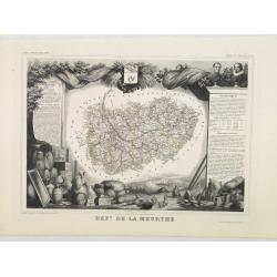
Dépt. De La Meurthe. N°53.
Map of the Meurthe region in France.Lovely map from one of the last decorative atlases of the nineteenth century.The rather simple map is framed by medallion portraits an...
Date: Paris, A. Combette, 1852
Selling price: ????
Please login to see price!
Sold in 2013
![Dépt. De La Sarthe. N°71. [ Le Mans ]](/uploads/cache/27152-250x250.jpg)
Dépt. De La Sarthe. N°71. [ Le Mans ]
Map of the Sarthe region, centered on Le Mans.Lovely map from one of the last decorative atlases of the nineteenth century.The rather simple map is framed by medallion po...
Date: Paris, A. Combette, 1852
Selling price: ????
Please login to see price!
Sold in 2010
![Dépt. De Vaucluse. N°81. [ Avignon, Carpentras, Apt ]](/uploads/cache/27161-250x250.jpg)
Dépt. De Vaucluse. N°81. [ Avignon, Carpentras, Apt ]
Map of the Vaucluse region in France, including Avignon, Carpentras, Apt, etc.Lovely map from one of the last decorative atlases of the nineteenth century.The rather simp...
Date: Paris, A. Combette, 1852
Selling price: ????
Please login to see price!
Sold in 2017
![Dépt. De La Vienne. N°83. [ Poitier ]](/uploads/cache/27164-250x250.jpg)
Dépt. De La Vienne. N°83. [ Poitier ]
Map of the Vienne region in France, centered on the town Poitier.Lovely map from one of the last decorative atlases of the nineteenth century.The rather simple map is fra...
Date: Paris, A. Combette, 1852
Selling price: ????
Please login to see price!
Sold in 2009
![Dépt. De La Hte. Vienne. N°84. [ Limoges]](/uploads/cache/27165-250x250.jpg)
Dépt. De La Hte. Vienne. N°84. [ Limoges]
Map of the Upper Vienne region, centered on the town Limoges, famous for its porcelain.Lovely map from one of the last decorative atlases of the nineteenth century.The ra...
Date: Paris, A. Combette, 1852
Selling price: ????
Please login to see price!
Sold in 2009

Le Vie Ferrate e le Postali della Francia Meridionale . . .
Uncommon map of South of France and part of Spain prepared by Francesco Costantino Marmocchi. Above the map "Geografia Commerciale". From "Il Globo Atlante...
Date: Genova, Paolo Rivara fu Giacomo, 1858
Selling price: ????
Please login to see price!
Sold in 2020
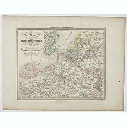
Le Vie Ferrate e le Postali della Francia Settentrionale . . .
Uncommon map of North of France and part of Belgium and England prepared by Francesco Costantino Marmocchi. Above the map "Geografia Commerciale". From "Il...
Date: Genova, Paolo Rivara fu Giacomo, 1858
Selling price: ????
Please login to see price!
Sold in 2020
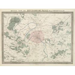
Nouvelle Carte des Environs de Paris.
Fine map of Paris and its contiguous outskirts, showing the early railway system of the area.From Atlas des Chemins de Fer published by Napoléon Chaix and printed by Imp...
Date: Paris, 1863
Selling price: ????
Please login to see price!
Sold in 2011
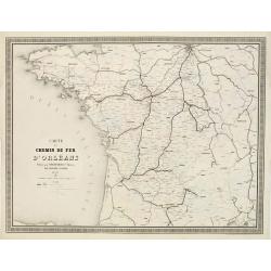
Carte du Chemin de Fer d'Orléans..
Fine map showing the early railway system of a large area extending westwards and southwards from Paris.From Atlas des Chemins de Fer published by Napoléon Chaix and pri...
Date: Paris 1863
Selling price: ????
Please login to see price!
Sold in 2011
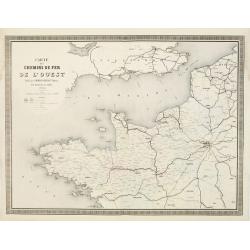
Carte des Chemins de Fer de l'Ouest..
Fine map showing the early railway system of a large area extending westwards from Paris as far as the coasts of Brittany.It includes part of the northern regions and the...
Date: Paris 1863
Selling price: ????
Please login to see price!
Sold
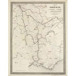
Carte des Chemins de Fer de Paris à Lyon et à la Méditerranée.
Fine map showing the early railway system of a large area extending from Paris to South East France.From Atlas des Chemins de Fer published by Napoléon Chaix and printed...
Date: Paris 1863
Selling price: ????
Please login to see price!
Sold in 2011
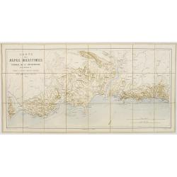
Cartes des Alpes Maritimes Littoral de la Méditerranée aux environs de Fréjus, Cannes, Grasse, Antibes, Nice, Monaco et Menton.
Folding-map of the Maritime Alps and the Mediterranean coastline of Fréjus, Cannes, Grasse, Antibes, Nice, Monaco, and Menton. Engraved by Erhard, geographer and engrave...
Date: Paris, 1870
Selling price: ????
Please login to see price!
Sold in 2008
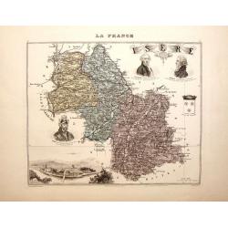
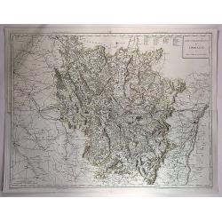
La France - Isere.
Nice decorated hand colored map of the Isere department of France. There are five cartouches including portraits of Vaucanson, Barnave & Bayart, the city of Grenoble ...
Date: Paris, 1878
Selling price: ????
Please login to see price!
Sold in 2014
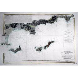
Carte particulière des cotes de France Dept. du Var...
Very large sea chart of a part of the Provence - Côte d'Azur region. From Hyères to Cap Camarat. Includes Ile de Porquerolles, Port-Cros, Ile du Levant. Dated 1843 but ...
Date: Paris, 1879
Selling price: ????
Please login to see price!
Sold in 2016
