Browse Listings in Europe > France > France Provinces
![[Les anciennes provinces Françaises à la ville de Saint Denis].](/uploads/cache/41682-250x250.jpg)
[Les anciennes provinces Françaises à la ville de Saint Denis].
Nine small chromolithography's trade cards for Ville de Saint Denis, each with French regions and places, with description in French on each verso.Cards of the regions : ...
Date: Paris, circa 1900
Selling price: ????
Please login to see price!
Sold in 2018
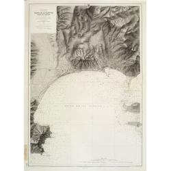
Mer Méditerranée - Côte de France - Golfe de la Napoule Rade de Cannes. . .
Large centered on the Gulf of La Napoule with the harbour of Cannes, the islands Sainte Marguerite and Saint Honorat on the right side. Showing towns, buildings, banks, ...
Date: Paris, 1903 updated 1931
Selling price: ????
Please login to see price!
Sold
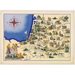
Basque - Bearn - Bigorre.
Very decorative, informative map of Basque - Bearn - Bigorre in south western France. Including the towns of Biarritz, Dax, Bayonne, Lourdes, etc. The map is filled with ...
Date: France, 1943
Selling price: ????
Please login to see price!
Sold in 2013
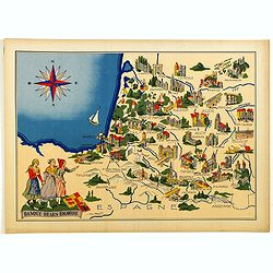
Basque - Bearn - Bigorre.
Very decorative, informative map of Basque - Bearn - Bigorre in south western France. Including the towns of Biarritz, Dax, Bayonne, Lourdes, etc. The map is filled with ...
Date: France, 1943
Selling price: ????
Please login to see price!
Sold in 2014
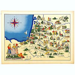
Basque - Bearn - Bigorre.
Very decorative, informative map of Basque - Bearn - Bigorre in south western France. Including the towns of Biarritz, Dax, Bayonne, Lourdes, etc. The map is filled with ...
Date: France, 1943
Selling price: ????
Please login to see price!
Sold in 2016
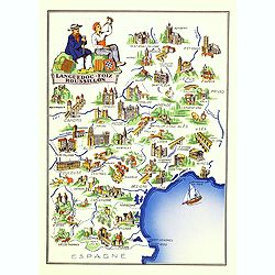
Languedoc - Foix Roussillon.
Very decorative, informative map of Languedoc - Foix Roussillon region in south eastern France. Including the towns of Carcassonne, Montpellier,, Albi, Toulouse, etc.The ...
Date: France, 1943
Selling price: ????
Please login to see price!
Sold in 2016
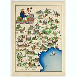
Languedoc - Foix Roussillon.
This is a very decorative, informative map of the Languedoc - Foix Roussillon region in southeastern France, including the towns of Carcassonne, Montpellier,, Albi, Toulo...
Date: France, 1943
Selling price: ????
Please login to see price!
Sold in 2023
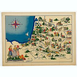
Languedoc - Foix Roussillon.
Very decorative, informative map of Languedoc - Foix Roussillon region in south eastern France. Including the towns of Carcassonne, Montpellier,, Albi, Toulouse, etc.The ...
Date: France, 1943
Selling price: ????
Please login to see price!
Sold in 2022
