Browse Listings in Europe > France > France Provinces
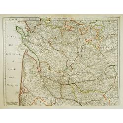
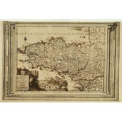
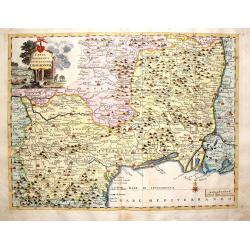
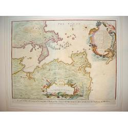
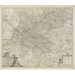
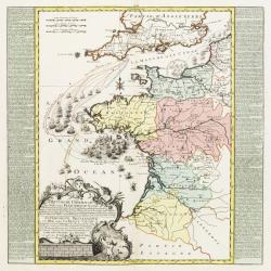
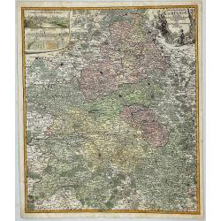
Carte du Bourdelois du Perigord et des provinces voisines..
Map covering the area from La Rochelle till the surrounding country of Bordeaux to the south and till Limoges and Cahors to the east.
Date: Paris 1714
Selling price: ????
Please login to see price!
Sold
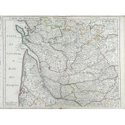
Carte du Bourdelois du Perigord et des Provinces voisines. . .
Finely detailed map of the Bordeaux region of France by Guillaume de L'Isle. Shows the French coast at the Bay of Biscay, the Garonne River and the port city of Bordeaux....
Date: Paris, 1714
Selling price: ????
Please login to see price!
Sold in 2010
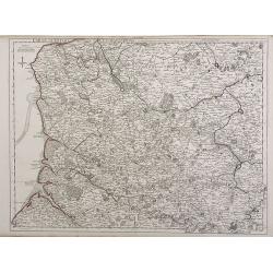
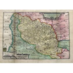
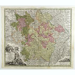
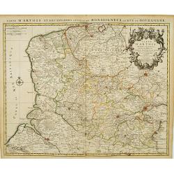
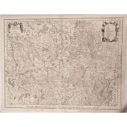
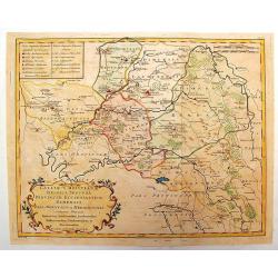
Carte d'Artois et des Environs ou lon voit le Ressort du Conseil Provincial d'Artois.
Finely detailed map of the Artois region of northern France bordering Belgium, showing the cities of Douai, Arras and Lille. Once a state of the Holy Roman Empire, Artois...
Date: Paris, 1716
Selling price: ????
Please login to see price!
Sold in 2010
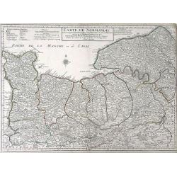
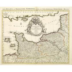
Carte de Normandie ousont marquez exacteme Les Pays ou Contrees enferm ees dascette Province aussi bien que les Villes Bourgs Paroissese.
Finely detailed map of the Normandy region of France by Guillaume de L'Isle. Shows the coastline along the English channel, along with the towns and villages, forests, ab...
Date: Paris, 1716
Selling price: ????
Please login to see price!
Sold in 2010
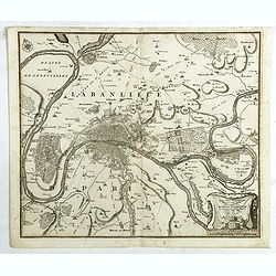
Agri Parisiensis. . .
A detailed map of Île-de-France centered on Paris. Paris is still quite small - Montmartre, Les Invalides, and others are shown as small separate villages. Extends until...
Date: Nuremberg, ca 1716
Selling price: ????
Please login to see price!
Sold in 2019
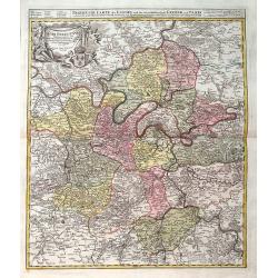
Carte de la Beauce du Gatinois de la Sologne et Pays voifins compris dans la Generalite d\'Orleans.
Detailed map of region of central France south of Paris. The Loire River is depicted with the city of Orleans in the center of the map. The Loire was once an important na...
Date: Paris, 1718
Selling price: ????
Please login to see price!
Sold in 2010
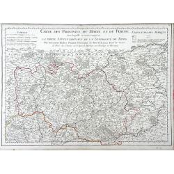
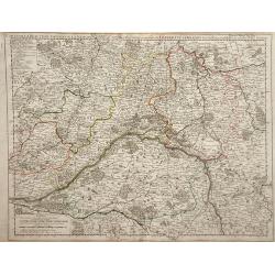
Carte des Provinces du Maine et du Perche dans Laquelle se trouve comprise La Partie Septentrionale De La Generalite De Tours
Finely detailed map of the province of Maine in northwestern France by Guillaume de L'Isle. Cities, villages, rivers, forests and mountains of the regions are depicted. T...
Date: Paris, 1719
Selling price: ????
Please login to see price!
Sold in 2010
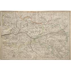
Le Gouvernement de Normandie...
Very detailed map of Normandy. In the south the river Loire, and in utmost left part of Jersey.
Date: Amsterdam, ca. 1720
Selling price: ????
Please login to see price!
Sold
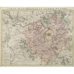
Carte de la prevosté et vicomté de Paris.
Paris and the surrounding territory including major roads.Guillaume de l'Isle (1675-1726) was the son of a cartographer and pupil of Jean Dominique Cassini, who, among ot...
Date: Amsterdam, 1720
Selling price: ????
Please login to see price!
Sold
Carte Particuliere d'Anjou et de Touraine, ou de la Partie Meridionale de la Generalite de Tours.
Map of the Anjou region of western France along the Loire River. Include are the cities Tours, Blois and Ancenis (from right to left) along the Loire.left margin: 3/4&quo...
Date: Paris, 1720
Selling price: ????
Please login to see price!
Sold in 2010
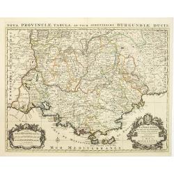
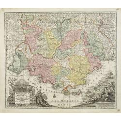
La Provence divisée en ses vigueries et terres adjacentes. . .
Detailed map of southern France. Showing the cities of Marseille, St.Tropez, Cannes, Nice, Antibes, Aix, Orange, Barcelonette, Senez., and Monaco, etc.Prepared by one of ...
Date: Amsterdam, ca 1720
Selling price: ????
Please login to see price!
Sold in 2010
Le Duché et Gouvernement de Normandie divisée en Haute et Basse Normandie.
An attractive large-scale map depicting Normandy. Embellished with a large title-cartouche. Prepared by one of the greatest French mapmakers Hubert Jaillot, and republish...
Date: Amsterdam, ca. 1720
Selling price: ????
Please login to see price!
Sold in 2010
Comte de gouvernement général de Provence divisé en ses sénéchaussees et vigurie. . .
Map of Provence prepared by Frederik de Wit. The copper plate was acquired by Pierre Mortier. The Amsterdam publishing firm of Covens and Mortier (1721 - c. 1862) was the...
Date: Amsterdam, 1720
Selling price: ????
Please login to see price!
Sold in 2014
Le comte d'Artois. . .
A detailed map of Artois with an inset view of Arras. Decorated with old hand color, a title cartouche, small coat of arms, compass rose, and distance scale.
Date: Paris, ca 1725
Selling price: ????
Please login to see price!
Sold in 2019
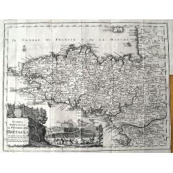
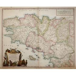
Carte du gouvernement de Bretagne, suivant les nouvelles observations..
Uncommon edition of this map of a province of France. With decorative title cartouche lower left corner.This example is unusual in having the additional separately engrav...
Date: Amsterdam 1728
Selling price: ????
Please login to see price!
Sold
Carte de Loraine, suivant les nouvelles observations..
With decorative title cartouche lower left corner.This example is unusual in having the additional separately engraved decorative framework border around the map, the res...
Date: Amsterdam 1728
Selling price: ????
Please login to see price!
Sold
Nouvelle Cartemarine croissante...Normandie, Vimeux, et Ponthieu, entirant depuis Etaples...
A detailed copper-engraved sea chart of a part of Normandy, from Dieppe until Etaples.Locates a number of towns along the coast, including Montreuil, Berck, Rue, Saint-Va...
Date: Amsterdam, 1728
Selling price: ????
Please login to see price!
Sold in 2016
Carte du Gouvernement de L'Isle de France...
A fine map of the Isle de France (Paris) region of France by Peter Van Der Aa in Paris. From the book: “La Geographie Moderne, Naturelle, Historique & Politique” ...
Date: Leiden, 1729
Selling price: ????
Please login to see price!
Sold in 2016
Mappa Geographica in qua Ducatus Lotharingiae et Barr
A very decorative map of the Lorraine region in France. Detail includes that of the towns, cities, and topography. It has a title cartouche showing people hunting and mak...
Date: Nuremberg, 1730
Selling price: ????
Please login to see price!
Sold in 2016
Provincia Gallis la Provence dicta..
Seutter's well-engraved map of southern France has two large decorative cartouche. Including the towns of Marseille, Toulouse, St.Tropez, Cannes, Antibes, etc.Matthaus Se...
Date: Nuremberg 1730
Selling price: ????
Please login to see price!
Sold in 2017
Mappa Geographica in qua Ducatus Lotharingiae...
Map of eastern France with the Alsace area, centered on Metz.Matthaus Seutter the elder first published his "Atlas Geographicus" in 1720 and added to the conten...
Date: Augsburg, 1730
Selling price: ????
Please login to see price!
Sold in 2017
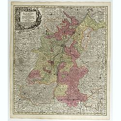
Alsatia Landgraviatus . . .
Map of eastern France centered on Strasburg and Basel in the South.Matthaus Seutter the elder first published his "Atlas Geographicus" in 1720 and added to the ...
Date: Augsburg, 1730
Selling price: ????
Please login to see price!
Sold in 2017
Comitatus Hanoviae . . .
A fine impression of this decorative map centered on Mons and Valenciennes with its uncolored title cartouche.Matthaus Seutter the elder first published his "Atlas G...
Date: Augsbourg, 1730
Selling price: ????
Please login to see price!
Sold in 2018
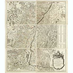
Le Theatre de la Guerre sur le Haut Rhein ou Cours du Rhein. . .
Very detailed six sheet map of Alsace centered on River Rhine.Gilles Robert de Vaugondy (1688–1766), also known as Le Sieur or Monsieur Robert, and his son, Didier Robe...
Date: Paris, 1735
Selling price: ????
Please login to see price!
Sold
Nouvelle Carte du golfe de Marseille.
Highly detailed, very large, copper engraved map depicting the bay of Marseille. The map is oriented with North on bottom right and decorated with a large compass rose. ...
Date: Paris, 1736
Selling price: ????
Please login to see price!
Sold in 2014
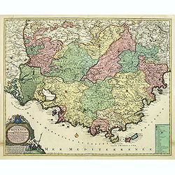
Praefectura generalis Languedociae olim Occitania.
Detailed map of Languedoc and contiguous regions. Published by Gerard and Leonard Valk.
Date: Amsterdam, 1740
Selling price: ????
Please login to see price!
Sold in 2011
Carta Geografica del Governo del l\'Isola de Francia.
Fine copperplate hand-colored map of Paris and its surroundings. Features the region of Isle de France. Decorated by a splendid cartouche showing the Fontainbleau Palace....
Date: Venice, 1740
Selling price: ????
Please login to see price!
Sold in 2013
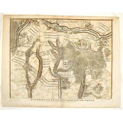
Plan of the Battle of Malplaquet Gained By the Allies Sep.11, 1709.
Detailed hand-colored plan of the bloodiest battle of the 18th century, fought during the War of the Spanish Succession (1701-14). Paul de Rapin (1661-1725) was a French...
Date: London, 1740
Selling price: ????
Please login to see price!
Sold in 2016
Carta Geographica del Governo della Linguadocca.
Nice hand colored map of the French Mediterranean, centered on Marseilles. Decorative cartouche of the countryside. Beautifully engraved by Giambattista Albrizzi.
Date: Venice, 1740
Selling price: ????
Please login to see price!
Sold in 2016
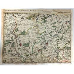
Carte Particuliere des Environs de Menin, Courtray, Ypre, Dixmude et Deynse
An engraved map of the region. Includes the cities of Menin, Courtray, Ypre, Dixmude and Deynse. The title appears above the map with the scale with the names of Covens a...
Date: Amsterdam, 1740
Selling price: ????
Please login to see price!
Sold in 2016
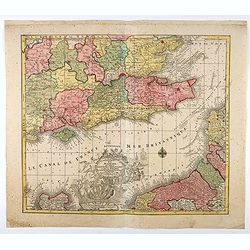
Carta Geografica del Governo di Guienna e Guascogna
A map of South Western France from "Atlante Novissimo che Contiene Tutte le Parti del Mondo". The map shows the region from La Rochelle, south to the Pyrenées ...
Date: Venice, 1740
Selling price: ????
Please login to see price!
Sold in 2016
Duche et Gouvernment General de Normandie. . .
A splendid map of Normandy by the German cartographer Seutter, published in the first half of the eighteenth century. Map stretches from Cherbourg in the west, to Alecon ...
Date: Augsburg, ca 1740
Selling price: ????
Please login to see price!
Sold in 2018
Typus choro-Topographicus regiae et totius Orbis celebrrimae urbis Lutetiae Parisiorum. . .
Map of Paris and its surrounding areas, covering more or less present-day Paris.Matthaus Seµtter the elder first published his "Atlas Geographicus" in 1720 and...
Date: Augsburg, ca. 1740
Selling price: ????
Please login to see price!
Sold in 2021
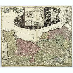
La plus grande partie de la Manche, qui contient les Côtes d'Angleterre...
Map of the English Channel. With a large decorative vignette cartouche which includes Neptune and his sea horses, Apollo, a sailing ship, and other allegorical figures.T....
Date: Augsburg, 1740
Selling price: ????
Please login to see price!
Sold in 2021
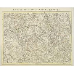
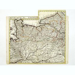
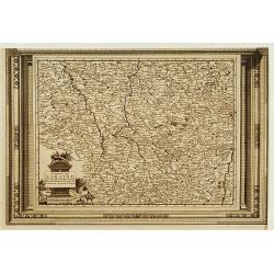
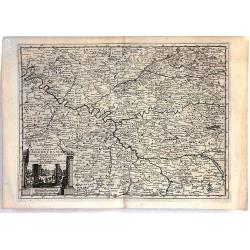
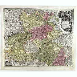
Partie Meridionale De Champagne. . .
Very detailed, topographical map of the southern Champagne. Showing fortified cities, roads, towns, rivers, lakes, forests, etc. The map is from a Dutch edition of De L'I...
Date: Amsterdam c. 1745
Selling price: ????
Please login to see price!
Sold
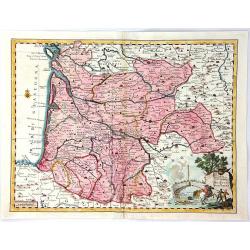
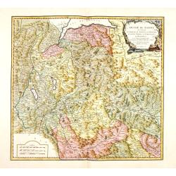
Le Gouvern.t Général du Dauphiné. . .
With decorative cartouche with dolphins.
Date: Paris, 1745
Selling price: ????
Please login to see price!
Sold
"Plan of Attack of Camaret Bay, on the Coast of Bretagne ..."
An interesting and attractive map of Camaret bay in Brittany. The piece depicts a battle scene between British and French naval forces in the vicinity of Brest.It feature...
Date: London, ca 1745
Selling price: ????
Please login to see price!
Sold in 2008
Le cours du Rhin de Bale à Hert près Philisbourg contenant L\'Alsace et partie du Brisgau..
The first map of the Rhine valley on such a large scale. To the lower left a scale cartouche and a small inset of Basle.With fine title cartouche upper rightLe Rouge (171...
Date: Paris, 1745
Selling price: ????
Please login to see price!
Sold in 2008
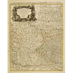
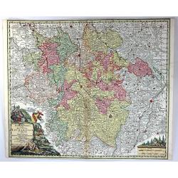
Le Gouvernement General de Languedoc Divisé..
Detailed map of the Southwest of France centred on Toulouse. The map is densely engraved with information with particular emphasis on the fortified cities, which are coll...
Date: Amsterdam c. 1745
Selling price: ????
Please login to see price!
Sold
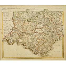
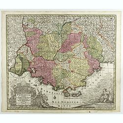
Carte de Provence et des Terres Adjacentes.
Topographically detailed map of the region of Provence in south-eastern France. Relief shown pictorially.The map is from a Dutch edition of De L'Isle's work entitled, Atl...
Date: Amsterdam c. 1745
Selling price: ????
Please login to see price!
Sold
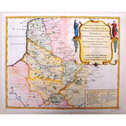
Carte D'Artois ET Des Environs..
Topographically detailed regional map of the Artois region in northern France. The map extends from Dunkirk and Abeville in the West to Doui, Cambrai and Lille in the Eas...
Date: Amsterdam c. 1745
Selling price: ????
Please login to see price!
Sold
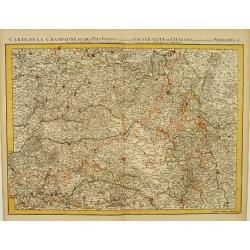
Carte De La Champagne et des Pays Voisins.. Chalons.. Soissons &c.
Very detailed, topographical map of Champagne and surrounding regions of Chalons and Soissons, Reims, Vedun, Mouzon, Sean, Charlemont, etc. Showing fortified cities, road...
Date: Amsterdam c. 1745
Selling price: ????
Please login to see price!
Sold
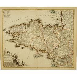
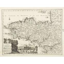
Duché et gouvernement General de Bretagne Divisé..
Highly detailed map of Brittany, in north-western France. Beautifully engraved with a decorative title cartouche depicting Poseidon and Hermes, a compass rose and table o...
Date: Amsterdam c. 1745
Selling price: ????
Please login to see price!
Sold
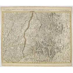
Le Cours du Rhin au dessus de Strasbourg et les Païs Adjacens.
Large, detailed map illustrating part of the flow of the river Rhine. It particularly depicts the stretch of river marking the natural border between Switzerland, France ...
Date: Amsterdam c. 1745
Selling price: ????
Please login to see price!
Sold in 2016
![Carte du Bourdelois du Perigord.. [and] Carte Du Bearn de La Bigorre de L'Armagnac.. (2 sheets)](/uploads/cache/21538-250x250.jpg)
Carte du Bourdelois du Perigord.. [and] Carte Du Bearn de La Bigorre de L'Armagnac.. (2 sheets)
Large, detailed map of South-western France, encompassing the Aquitaine région (first sheet) and extending to the Spanish Border and Toulouse (second sheet).The map is f...
Date: Amsterdam c. 1745
Selling price: ????
Please login to see price!
Sold
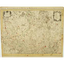
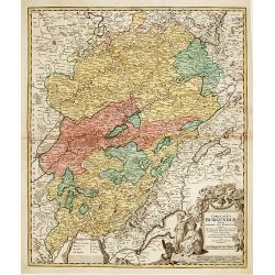
Partie Septentrionale du Duche de Bourgogne..
Large, detailed map of northern Burgundy, covering the region from Bar-sur-Seine in the North to Dijon and Auxonne in the South East. Shows illustrated topography with ma...
Date: Amsterdam c. 1745
Selling price: ????
Please login to see price!
Sold
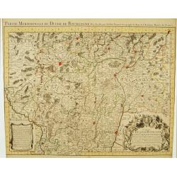
Partie Meridionale du Duche de Bourgogne..
Large, detailed map of northern Burgundy, covering the region from Autun and Dole in the North to Charolles and Mâcon in the South. Shows illustrated topography with man...
Date: Amsterdam c. 1745
Selling price: ????
Please login to see price!
Sold
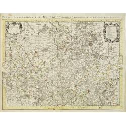
Partie Septentrionale du Duche de Bourgogne . . .
Large, detailed map of northern Burgundy, covering the region from Bar-sur-Seine in the North to Dijon and Auxonne in the South East. Shows many villages, towns, roads an...
Date: Amsterdam, ca. 1745
Selling price: ????
Please login to see price!
Sold
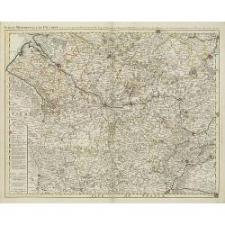
Partie meridionale de Picardie dressee sur les operations geometriques de Mrs. Lesperson & de Rousseville et sur plusieurs autres memoires Par Guillaume Del'isle . . .
Engraved map of the Picardie region in northern France. Urban areas in color. Relief is shown pictorially. Shows forests, Roman roads, churches, abbeys by religious order...
Date: Amsterdam, 1745
Selling price: ????
Please login to see price!
Sold in 2009
Gouvernement Général de L'Isle de France . . .
A fine engraved map centered on Paris metropolitan area and its vicinities in the Isle de France region. Decorative title and scale cartouches.The map is from a Dutch edi...
Date: Paris, ca. 1745
Selling price: ????
Please login to see price!
Sold in 2012
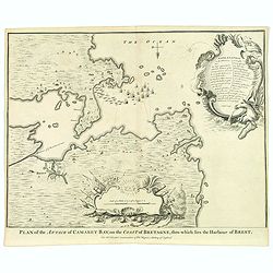
Plan of Attack of Camaret Bay, on the Coast of Bretagne. . .
An interesting and attractive map of Camaret bay in Brittany. The piece depicts a battle scene between British and French naval forces in the vicinity of Brest.It feature...
Date: London, ca 1745
Selling price: ????
Please login to see price!
Sold in 2020
Partie Septentrionale du Duche de Bourgogne ...
Large, detailed map of northern Burgundy, covering the region from Bar-sur-Seine in the North to Dijon and Auxonne in the South East. Embellished with 2 cartouches both d...
Date: Amsterdam, 1745
Selling price: ????
Please login to see price!
Sold in 2022
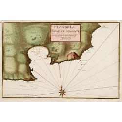
Plan de la Baye de Nagaye.
Prepared by Jacques Ayrouard and engraved by Louis Corne. Decorated with a large compass rose. From the rare chart book by Jacques Ayrouard: Recueil de plusieurs Ports .....
Date: Marseille, 1732 - 1746
Selling price: ????
Please login to see price!
Sold
![[Untitled Front views of the coastal relief of Provence]](/uploads/cache/23302-250x250.jpg)
[Untitled Front views of the coastal relief of Provence]
Copper engraving presenting separate front views of the coastal relief of Provence divided in stripes.It covers the area which extends from Cap Sicié as far as Monaco, i...
Date: Marseille, 1732 - 1746
Selling price: ????
Please login to see price!
Sold
![[Untitled] Front views of the Riviera.](/uploads/cache/24832-250x250.jpg)
[Untitled] Front views of the Riviera.
Copper engraving presenting separate front views of the Italian Riviera.It covers the whole Gulf of Genoa and Monaco.From the rare chart book by Jacques Ayrouard: Recueil...
Date: Marseille, 1732 - 1746
Selling price: ????
Please login to see price!
Sold
![[Untitled] Front views of the coastal relief of Corsica and Tuscany.](/uploads/cache/24834-250x250.jpg)
[Untitled] Front views of the coastal relief of Corsica and Tuscany.
Copper engraving presenting separate front views of the coastal relief of northern Corsica and the facing Tuscan shores, divided in stripes.From the rare chart book by Ja...
Date: Marseille, 1732 - 1746
Selling price: ????
Please login to see price!
Sold
![[Untitled] Front views of the coastal relief of the French Riviera.](/uploads/cache/24840-250x250.jpg)
[Untitled] Front views of the coastal relief of the French Riviera.
Separate front views depicting the coastal relief of French Riviera, divided in stripes.It covers the littoral zone between Monaco as far as the Iles Hyères.From the rar...
Date: Marseille, 1732 - 1746
Selling price: ????
Please login to see price!
Sold
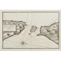
Plan du Passage Entre L isle Azinara et le Cap Azinara de Sardaigne.
Copper engraving depicting the northwestern tip of Sardinia and the southern tip of the Asinara Island.Oriented with West on top. Decorated with a large compass rose.From...
Date: Marseille, 1732 - 1746
Selling price: ????
Please login to see price!
Sold
![[Untitled] Front views of the Italian coastal relief.](/uploads/cache/24848-250x250.jpg)
[Untitled] Front views of the Italian coastal relief.
Copper engraving presenting separate front views of the Tyrrhenian as well as Ionian coastal relief of Italy, divided in stripes.From the rare chart book by Jacques Ayrou...
Date: Marseille 1732 - 1746
Selling price: ????
Please login to see price!
Sold
A New and Accurate Map of Savoy, Piemont, and Montferrat Exhibiting the Present Seat of War. . .
An attractive map of the Savoy and Montferrat regions of southeastern France and the northern Italian region of Piedmont on the Mediterranean Sea coast by Emmanuel Bowen...
Date: London, 1747
Selling price: ????
Please login to see price!
Sold in 2010
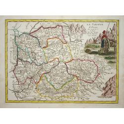
La savoye.
Nice map of the Savoie at the top the lake of Geneva and the Alps.
Date: Paris 1748
Selling price: ????
Please login to see price!
Sold
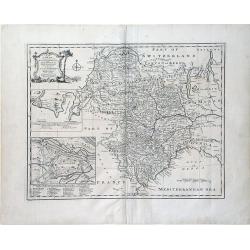
Duché de Savoye.
Detailed small map centered on Savoy, extending eastwards to include the Italian region Valle d'Aosta.From Atlas Portatif Universel, by Robert de Vaugondy. Page 53 outsid...
Date: Paris, later than 1748
Selling price: ????
Please login to see price!
Sold in 2019
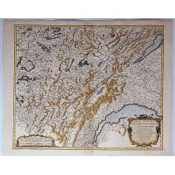
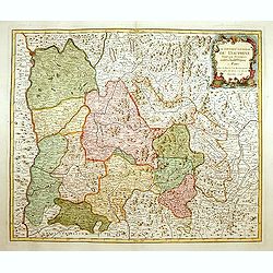
Partie Meridionale du Comte de Bourgogne ou Franche-Comte...
A striking map of the Burgundy (Bourgogne) and southern Franche-Comte region of eastern France by Robert de Vaugondy, published in 1749.It covers part of the southern Fra...
Date: Paris, 1749
Selling price: ????
Please login to see price!
Sold in 2018
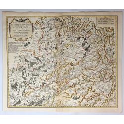
Partie Septentrionale du Comte de Bourgogne ou Franche Comte...
A striking, detailed map of the Burgundy and northern Franche-Comte region of eastern France by Robert de Vaugondy. It covers the modern day departments of Doubs, Haute-S...
Date: Paris, 1749
Selling price: ????
Please login to see price!
Sold in 2018
Carta geografica del governo della Bretagna. . .
From Volume II of Albrizzi's "Atlante Novissimo" after Guillaume de L'Isle. Showing Brittany divided into its Bishoprics and with all towns and cities marked, w...
Date: Venise, 1750
Selling price: ????
Please login to see price!
Sold
Comitatus Burgundiae tam in primarias ejus ..
A good map of Burgundy orientated with north at the top. Decorative title cartouche with three figures, scale cartouche, coat of arms and putti holding grapes.Lower part ...
Date: Augsburg 1750
Selling price: ????
Please login to see price!
Sold
Brittische Übermacht Zur See wieder Franckreich..
Fascinating and finely engraved map engraved by M.A.Lotter and sold by his father, T.Lotter.It describes naval skirmishes between the British and French during the Seven ...
Date: Paris 1750
Selling price: ????
Please login to see price!
Sold in 2010
Provincia Gallis la Provence dicta..
Seutter's well-engraved map has two large decorative cartouche. Including the towns of Marseille, Toulouse, St.Tropez, Cannes, Antibes, etc.
Date: Nuremberg 1750
Selling price: ????
Please login to see price!
Sold
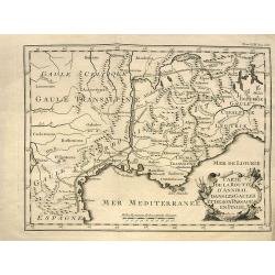
Carte de la route d'Annibal dans les Gaules et de son passage en Italie.
Interesting map showing the route of Hannibal. With south France and Liguria. After a map by Liebaux, a later edition probably from "Histoire Universelle".
Date: Paris, c1750
Selling price: ????
Please login to see price!
Sold in 2013
Carta Geografica del Governo della Bretagna.
Attractive and detailed map, showing Brittany divided into its bishoprics and with all towns and cities. Extending to Jersey. With a decorative title cartouche and a view...
Date: Venice, c1750
Selling price: ????
Please login to see price!
Sold in 2011
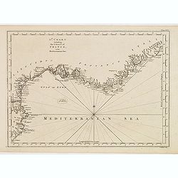
13th Chart including the coast of France, in the mediterranean sea.
Engraved chart of the coast of Provence and Languedoc, France, engraved by Thomas Jeffery's.
Date: London, ca.1750
Selling price: ????
Please login to see price!
Sold
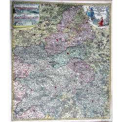
TABULA GEOGRAPHICA CAMPANIAE...
Decorative copper engraved map of Champagne. Very detailed, covering the region Champagne-Ardenne with Reims, Troyes, Châlons, Vitry, and Épernay. With an allegoric tit...
Date: Nuremberg, 1750
Selling price: ????
Please login to see price!
Sold in 2013
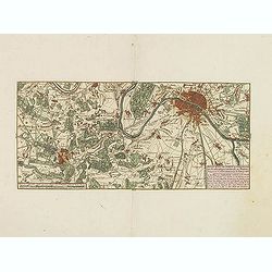
Nieuwe kaart van Parys en Versailles met de nabygelegen Landstreek en Plaatsen.
Very detailed map covering the vicinity of Paris from Versailles to Vincennes. Nice detail around Boid de Boulogne and St.Cloud
Date: Amsterdam, 1750
Selling price: ????
Please login to see price!
Sold in 2013
Artsia cum Finitimis Locis Seden ac Thatrum Belli ...
A fine large map of the Pas-de-Calais / Artois region in northern France, and part of Belgium between Calais, Abeville and Douay, with decorative figural cartouche. By Co...
Date: Nüremburg, 1750
Selling price: ????
Please login to see price!
Sold in 2016
Tabula Geographica Campaniae in Suas Sic Dictas. . .
A map of Champagne, the famous wine provence in France. On the top left are insert views of Reims and Troyes, and a decorative cartouche featuring a king and his subjects...
Date: Nuremberg, ca. 1750
Selling price: ????
Please login to see price!
Sold in 2018
Galliae Christianae Belgica Secunda Provinciae Ecclesiasticae Remensis
Nicely detailed copper engraved map covering the southwestern part of France. This map depicts the cities of Amiens, Senlis, Laon, Beauvais and Saint-Omer. Details includ...
Date: Paris, 1751
Selling price: ????
Please login to see price!
Sold in 2014
Galliae Christianae Belgicae Secundae Ecclesiasticae Provinciae Remensis
Very large, decorative title cartouche on an interesting Nolin map of Reims, Amiens & Senlis France. Engraved on copper plates by Dussy.J. B. Nolin 1657-1708)set up h...
Date: Paris, 1751
Selling price: ????
Please login to see price!
Sold in 2014
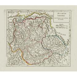
Duche de Savoye qui comprend le Chablais, le Fossigny, le Genevois, la Savoye Propre, la Tarentaise et la Maurienne, dresse d'apres la Grande Carte de Piemont de Tomaso Borgomo (i.e., Borgonio) et autres. . .
Finely and crisply engraved map of Savoy prepared by Robert de Vaugondy's map, from "Atlas Universel".Large decorative title cartouche in the upper right corner...
Date: Venice, ca.,1751
Selling price: ????
Please login to see price!
Sold
Gouvernement General de Bretagne divife dioceses ou recceptes.
An attractive map of Brittany that extends to the island of Belle-Île, just off of the Quiberon Peninsula. The map shows the divisions of the dioceses and is filled with...
Date: Paris, 1751
Selling price: ????
Please login to see price!
Sold in 2016
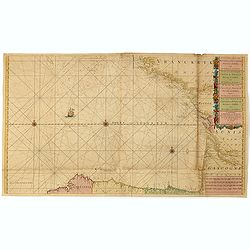
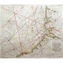
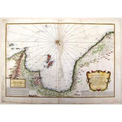
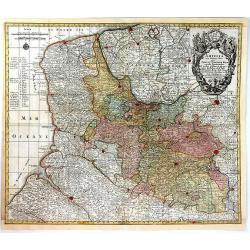
Nieuwe Generale Paskaart van de Bocht van Vrankryk Biscaia en Gallissia tussen I. de Ouessant en C. de Finisterre.
Rare chart of the Gulf of Biscay including all the south-west coast of France from Brest to the south and continuing along the Spanish coast, including Bilbao, until Ferr...
Date: Amsterdam, 1728-1751
Selling price: ????
Please login to see price!
Sold in 2015
