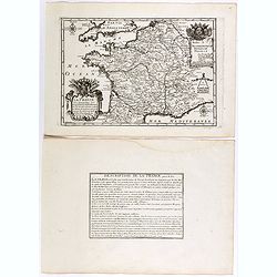
Browse Listings in Europe > France > France Provinces
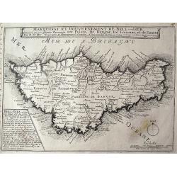
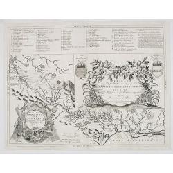
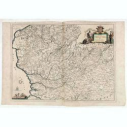
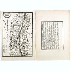
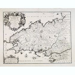
Marquisat et gouvernement de Bell-Isle divisée en ses quatre paroisses, Du Palais, De Bangor, De Lomaria, et de Sauzon.
Rare and detailed map of Belle-Isle off the coast of Brittany. The map provides very good detail of the topography, ports, cities and towns. With the large title banner, ...
Date: Paris, 1692
Selling price: ????
Please login to see price!
Sold in 2011
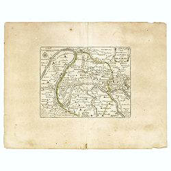
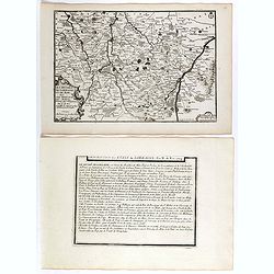
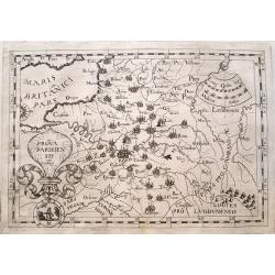
Les environs de Paris.
An interesting small map of present area of Paris by Nicolas de Fer. From his rare "Petit et Nouveau Atlas". The first edition was published in 1697 and was rep...
Date: Paris, 1692
Selling price: ????
Please login to see price!
Sold in 2023
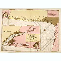
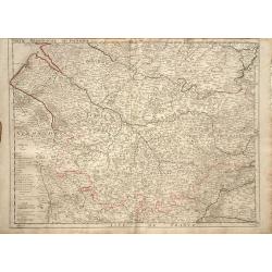
Carte Particulière des Costes de Guienne..
From the "Neptune Français", two charts on one sheet, in lower left showing the mouth of the Gironde till Bordeaux. The main chart depicting the coast of Gasco...
Date: Paris (Amsterdam), 1693
Selling price: ????
Please login to see price!
Sold
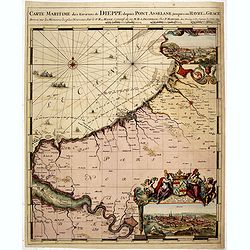
Carte Maritime des Environs de DIEPPE depuis PONT ASSELANE
From the first edition of Mortier's Neptune François showing the mouth of the Seine and inset panoramic views of Dieppe and Rouen. According to Koeman: ...the most expen...
Date: Amsterdam, 1693
Selling price: ????
Please login to see price!
Sold in 2015
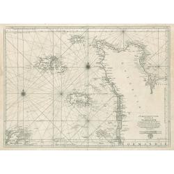
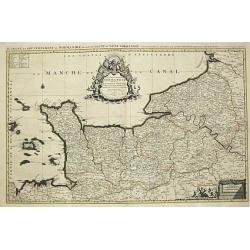
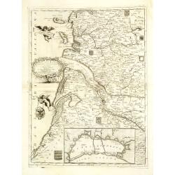
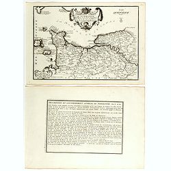
Carte Particuliere des Costes de Normandie
This is an original, uncolored sea chart of the coast of Normandy, France and the islands of Jersey Guernsey (Grenezey), and Alderny (Aurigny) that reside within the Engl...
Date: Paris 1693
Selling price: ????
Please login to see price!
Sold in 2023
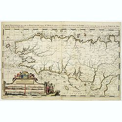
Carte Nouvelle des Costes De Bretagne depuis St. Malo jusques a l'emboucheure de la Riviere de Loire. . .
Chart of the French province of Brittany. From the first edition of Mortier's Atlas Maritime, showing the whole of Brittany and inset panoramic views of St.Malo, Brest, C...
Date: Amsterdam, 1693
Selling price: ????
Please login to see price!
Sold in 2011

St Tropez.
Early plan of St.Tropez. From his "Introduction à la fortification".
Date: Paris, 1693
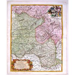
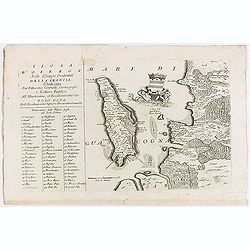
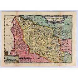
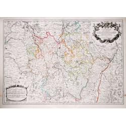
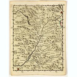
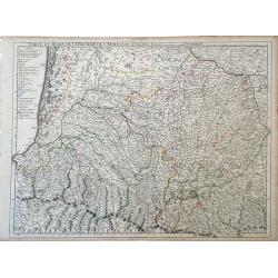
Il Limosino, Il Quercy e la Rovergue che Costituiscono Parte del Gouverno Generale di Guascogna
Highly detailed copper engraved map of Limousin & Quercy, regions located in Central France. The map includes the cities of Montauban, Villefranche sur Saonne, Limoge...
Date: Modena, 1693
Selling price: ????
Please login to see price!
Sold in 2015
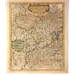
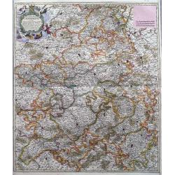
Partie Occidentale du Temporel de / l' Archeversche et Eslectorat de Mayence et le Haut et Bas Comte de Catzenellenboge
A large attractive map showing Mainz and Frankfurt along the course of the Rhine River, by N. Sanson in 1692, with a fine baroque title and scale cartouches. From “ Les...
Date: Paris, 1694
Selling price: ????
Please login to see price!
Sold in 2019
Disegno Idrografico del Canale Reale . . .
A decorative Coronelli map showing the Canal du Midi. It shows the extent of the canal from the Mediterranean sea at Narbonne to Toulouse. Featuring a pair of large coats...
Date: Venice, 1695
Selling price: ????
Please login to see price!
Sold in 2020
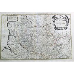
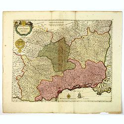
Le Comte d' Artois. Paris, 1693.
Alexis-Hubert Jaillot (1632-1712), French cartographer. He joined the Sanson heirs and redrew Nicolas Sanson's maps on a larger scale. "Atlas Nouveau" (1674), s...
Date: Amsterdam, 1696
Selling price: ????
Please login to see price!
Sold
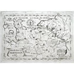
Le Duche et Gouvernement de Normandie divisee en Haute et Basse Normandie. Paris, 1695.
Alexis-Hubert Jaillot (1632-1712), French cartographer. He joined the Sanson heirs and redrew Nicolas Sanson's maps on a larger scale. 'Atlas Nouveau' (1674), sea-atlas '...
Date: Amsterdam, 1696
Selling price: ????
Please login to see price!
Sold
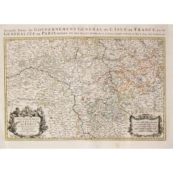
Seconde Partie du Gouvernement General de l\' Isle de France, ou la Generalite de Paris. Paris, 1692.
Alexis-Hubert Jaillot (1632-1712), French cartographer. He joined the Sanson heirs and redrew Nicolas Sanson's maps on a larger scale. 'Atlas Nouveau' (1674), sea-atlas '...
Date: Amsterdam, 1696
Selling price: ????
Please login to see price!
Sold in 2013
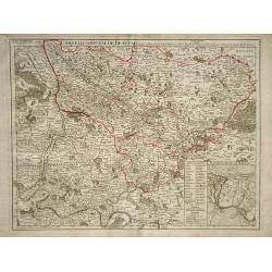
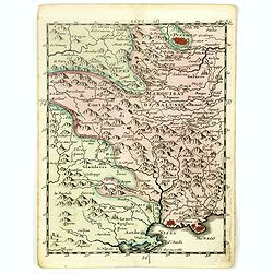
Contea dell' Artesia. Dedicata All' Illustriss, et Eccellentis: S. Bartolomeo Grimani Dal P. Coronelli.
Map of north of France, including Callais From the "Atlante Farnese". In 1683 the Venetians invaded Greece trying to wrest control from the Turks. Starting in t...
Date: Venice, 1696
Selling price: ????
Please login to see price!
Sold in 2020
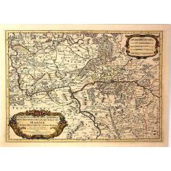
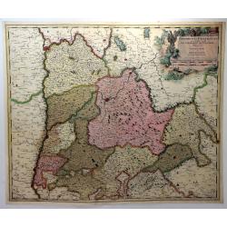
Partie Orientale du Temporel de l'Archevesché et Eslectorat de Mayence et le Comte de Remeck.
An attractive map of the eastern part of the Electorate of Mainz (Mayence) and the counties of Wertheim, Reinecke and Wuerzburch. Embellished with a large title and scale...
Date: Paris, 1696
Selling price: ????
Please login to see price!
Sold in 2019
Partie Occidentale du Temporel de l'Archevesché et Eslectorat de Treves
A fine map centred on Trier and the river Meuse, with its wine region. A figurative title cartouche in upper part and scale cartouche. By N. Sanson in 1692 from “ Les A...
Date: Paris, 1696
Selling price: ????
Please login to see price!
Sold in 2016
La Guienna, Medoc, Saintonge, Aunis. . .
A beautiful and flamboyantly engraved large-scale map of southwest of France with Bordeaux region with the Isles De Re and Oleron, and an inset plan of the fortified port...
Date: Venice, ca. 1696
Selling price: ????
Please login to see price!
Sold
Isola d'Oleron.
A beautiful map showing the isle of Oleron, located in the Bay of Biscay off the coast of France, from Vincenzo Coronelli's Corso Geografico Universale.A numbered key of ...
Date: Venice, 1698
Selling price: ????
Please login to see price!
Sold in 2012
Ducato di Normandi.
A beautiful and flamboyantly engraved large-scale map of Normandy, with a fine title cartouche featuring Leda in her carriage drawn by swans.On verso are plans of Le Havr...
Date: Venice, 1698
Selling price: ????
Please login to see price!
Sold
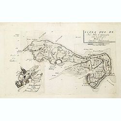
Isola del Re Nel Mare di Guascogna. . .
A beautiful map showing Ile de Ré in Bretagne, located in the Bay of Biscay off the coast of France, from Vincenzo Coronelli's Corso Geografico Universale.Italian text o...
Date: Venice, 1698
Selling price: ????
Please login to see price!
Sold
La Lorraine, qui Comprend les Duches de Lorraine et de Bar.
A handsome map of the Lorraine region of France. It includes the cities of Metz, Verdun and Nancy. The topography is detailed with trees, mountains and cities dotting th...
Date: Paris, 1700
Selling price: ????
Please login to see price!
Sold in 2016
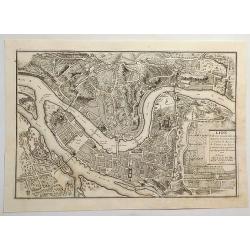
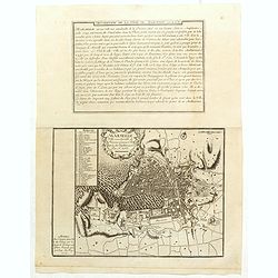
Lion, Ville Tres Considerable du Royaume.
A bird's-eye plan of Lion (Lyon) and vicinity that illustrates the strategic position of its fortifications on the Saône and the Rhône rivers. It provides an excellent ...
Date: Paris, 1700
Selling price: ????
Please login to see price!
Sold in 2023
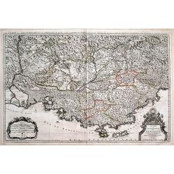
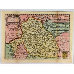
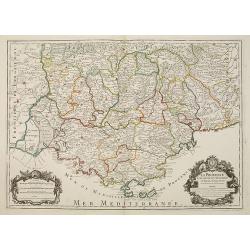
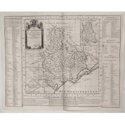
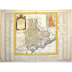
Le Comté et Gouvernement de Provence, divisée en ses vigueries...
Large scale map of Provence with immense detail after Sanson. Extends from Montélimar, Arles, and the Carmargue in the East, until Nice and Stroppo near Cuneo in the Wes...
Date: Amsterdam, ca. 1700
Selling price: ????
Please login to see price!
Sold in 2016
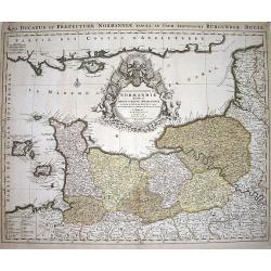
Le Duché et Gouvernement du Normandie diviseé...
Large scale map of Northern France, with excellent detail of La Manche. Latin title "Nova ducatus et praefecturae normanniae tabula, ad usum serenissimi burgundi...
Date: Amsterdam, ca1700
Selling price: ????
Please login to see price!
Sold in 2009
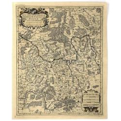
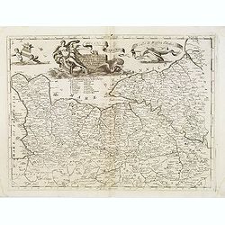
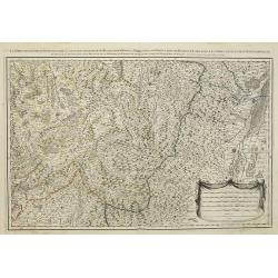
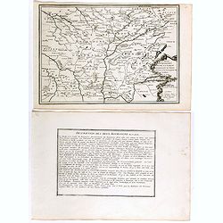
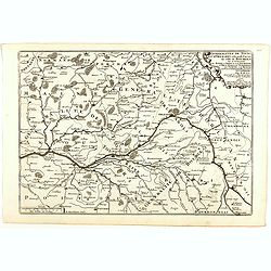
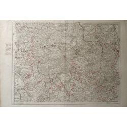
Praefectura Lugunensis Generalis...
A very detailed map of a part of South-Central France, centred on the former Auvergne region. Includes the cities of Périgueux, Limoges, Clermont-Ferrand, Montelimar, M�...
Date: Amsterdam, ca 1700
Selling price: ????
Please login to see price!
Sold in 2016
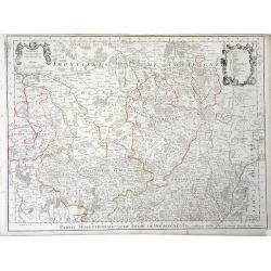
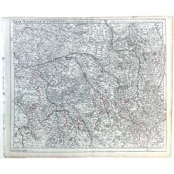
Comté et Gouvernement general de Champagne ou sont la Vraye Champagne, la Brie, le Remois, Retelois, Senonois, la Pertois, Bassigny. . .
A large and detailed map of the Champagne region, a part of Luxembourg in the north, and Auxerre in the south. Filled with place names and topographical information. With...
Date: Amsterdam, ca 1700
Selling price: ????
Please login to see price!
Sold in 2018
Gouvernement General de Languedoc. Divise en ses Vint Deux Diocesez.
A lovely late seventeenth century map of the central south French region of Languedoc, part of which borders the Mediterranean Sea by Dutch publisher and cartographer, Fr...
Date: Amsterdam, ca 1700
Selling price: ????
Please login to see price!
Sold in 2019
Delphinatus Praefectura Quae Gallis audit Gouvernement de Daufine.
A very detailed, antique map of the Dauphiné in the southeast of France by G. Valk. On the left the Rhône from Lyon, Vienne, Tournon-sur-Rhône, Valence to Montélimar....
Date: Amsterdam, ca. 1700
Selling price: ????
Please login to see price!
Sold in 2018
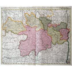
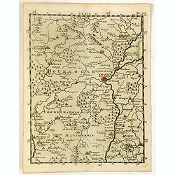
Partie Septrentionale Du Duche de Bourgogne. . .
Finely detailed map of the Duchy of Bourgogne, what is now the wine growing region of Burgundy in France by Guillaume de L'Isle. A beautifully illustrated distance key, f...
Date: Paris, 1703
Selling price: ????
Please login to see price!
Sold in 2010
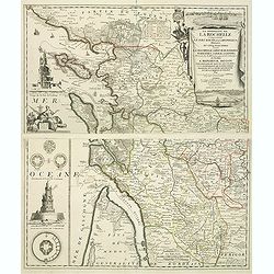
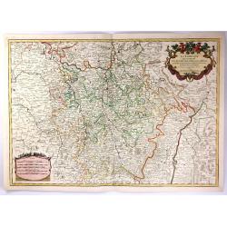
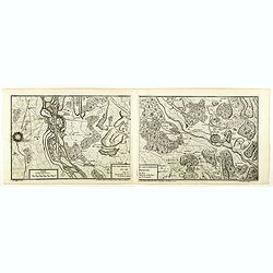
La Generalite de La Rochelle Comprenant le Pays d'Aunis, la Saintonge, &c., Divisee en Cinq Elections . . .
A stunning and strongly engraved map in two sheets and showing La Rochelle, Ile d'Orléron, Ile Ré and the entrance of the river Gironde. The map extends to include Roch...
Date: Paris, 1703
Selling price: ????
Please login to see price!
Sold in 2011
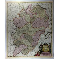
Superior Burgundiae Comitatus; Vulgo La Franche Comte.
A detailed map of Upper Burgundy and its contiguous regions. Bottom right is a beautiful title cartouche featuring three putti.Gerard Valk (1652–1726) and his son Leona...
Date: Amsterdam, 1703
Selling price: ????
Please login to see price!
Sold in 2018
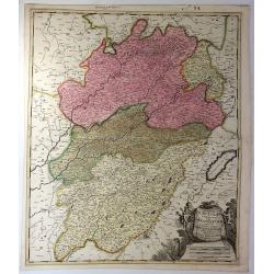
Superior Burgundiae Comitatus Vulgo la Franche Comte. . .
A detailed map of Upper Burgundy and its contiguous regions. Bottom right is a beautiful title cartouche featuring three putti.Gerard Valk (1652–1726) and his son Leona...
Date: Amsterdam, 1703
Selling price: ????
Please login to see price!
Sold in 2018
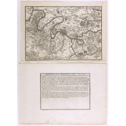
Carte Du Diocese de Narbonne. . .
Finely detailed map of the Diocese of Narbonne, a Catholic Diocese that existed in southwestern France until the French Revolution, by Guillaume de L'Isle. A nice inset m...
Date: Paris, 1704
Selling price: ????
Please login to see price!
Sold in 2010
Les prevotez, senechaussee, et comte, qui font partie des Balliages de Vosges ou Mirecour . . .
Map of Vosges including the city of Epinal, Colmar.
Date: Paris, 1704
Selling price: ????
Please login to see price!
Sold in 2011
Environs de Paris.
Map centered on Paris, with its surroundings, from Nicolas de Fer's "L'Atlas curieux ou le Monde réprésente dans des cartes. "The "Atlas Curieux" is...
Date: Paris, 1705
Selling price: ????
Please login to see price!
Sold in 2020
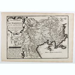
Les environs de Marseille et de son territoire . . .
Map centered on Marseille with nice detail of it surroundings, from Nicolas de Fer's "L'Atlas curieux ou le Monde réprésente dans des cartes. "The "Atlas...
Date: Paris, 1705
Selling price: ????
Please login to see price!
Sold
Gouvernement de Provence, generalité d'Aix.
Map of the Provence region, from Nicolas de Fer's "L'Atlas curieux ou le Monde réprésente dans des cartes. "The "Atlas Curieux" is a geographic ency...
Date: Paris, 1705
Selling price: ????
Please login to see price!
Sold
Haute et Basse Alsace, suntgout, Brisgou, et Ortenou.
Map of the Alsace region, from Nicolas de Fer's "L'Atlas curieux ou le Monde réprésente dans des cartes. "The "Atlas Curieux" is a geographic encycl...
Date: Paris, 1705
Selling price: ????
Please login to see price!
Sold in 2022
Le cours de la Sare aux environs de la quellese trouve diverses provinces qui composent la province de la Sare ou Lorraine Allemande.
Map of the Lorraine region with a part of west Germany, from Nicolas de Fer's "L'Atlas curieux ou le Monde réprésente dans des cartes. "The "Atlas Curieu...
Date: Paris, 1705
Selling price: ????
Please login to see price!
Sold in 2020
Marseille ville considerable de Provence fameux port sur la mer de Mediterranée par N. De Fer.
Map centered on Marseille with nice detail of it surroundings, from Nicolas de Fer's "L'Atlas curieux ou le Monde réprésente dans des cartes. "The "Atlas...
Date: Paris, 1705
Selling price: ????
Please login to see price!
Sold in 2019
Les deux Bourgognes Duché et Comté . . .
Map of the Bourgogne region, from Nicolas de Fer's "L'Atlas curieux ou le Monde réprésente dans des cartes. "The "Atlas Curieux" is a geographic enc...
Date: Paris, 1705
Selling price: ????
Please login to see price!
Sold in 2019
La France ses conquêtes, ses acquisitions et ses bornes . . .
General map of France, from Nicolas de Fer's "L'Atlas curieux ou le Monde réprésente dans des cartes. "The "Atlas Curieux" is a geographic encyclope...
Date: Paris, 1705
Selling price: ????
Please login to see price!
Sold in 2020
Les Duchez, de Lorraine, et de Bar . . .
Map of the Lorraine region, from Nicolas de Fer's "L'Atlas curieux ou le Monde réprésente dans des cartes. "The "Atlas Curieux" is a geographic ency...
Date: Paris, 1705
Selling price: ????
Please login to see price!
Sold in 2020
Gouvernement general de Bretagne ou se trouve la Generalité de Nantes.
Map of Bretagne, from Nicolas de Fer's "L'Atlas curieux ou le Monde réprésente dans des cartes. "The "Atlas Curieux" is a geographic encyclopedia of...
Date: Paris, 1705
Selling price: ????
Please login to see price!
Sold in 2020
Gouvernement general de Normandie . . .
Map of Normandy region, from Nicolas de Fer's "L'Atlas curieux ou le Monde réprésente dans des cartes. "The "Atlas Curieux" is a geographic encyclop...
Date: Paris, 1705
Selling price: ????
Please login to see price!
Sold in 2018
Generalitez de Tours, et d'Orleans et Grande Partie de celle de Bourges . . .
Map of Tours and Orleans regions, from Nicolas de Fer's "L'Atlas curieux ou le Monde réprésente dans des cartes. "The "Atlas Curieux" is a geographi...
Date: Paris, 1705
Selling price: ????
Please login to see price!
Sold in 2020
Les environs des deux Brisachs et de Fribourg.
A two sheet map of Brisachs and Fribourg, from Nicolas de Fer's "L'Atlas curieux ou le Monde réprésente dans des cartes. "The "Atlas Curieux" is a g...
Date: Paris, 1705
Selling price: ????
Please login to see price!
Sold in 2018
Les generalitez de Bordeaux, de La Rochelle, et de Limoges . . .
Map of the Gascony region, including Bordeaux, La Rochelle and Limoges, with several provinces such as Saintonge, Limousine ..., from Nicolas de Fer's "L'Atlas curie...
Date: Paris, 1705
Selling price: ????
Please login to see price!
Sold in 2021
Les environs des deux Birsachs.
Map of old and new Brisachs, with Colmar and Fribourg from Nicolas de Fer's "L'Atlas curieux ou le Monde réprésente dans des cartes. "The "Atlas Curieux&...
Date: Paris, 1705
Selling price: ????
Please login to see price!
Sold in 2018
Le Comte D'Artois.
An interesting map of Artois. France, first drawn by Daniel de la Feuille in 1706. With ornamental title-cartouche, title cartouche and view of the city of Abras. From �...
Date: Paris, 1706
Selling price: ????
Please login to see price!
Sold in 2019
![La Bretagne diviseé en ses neuf eveschés qui font aussi [. . .] generalité de Nantes. . .](/uploads/cache/25301-250x250.jpg)
La Bretagne diviseé en ses neuf eveschés qui font aussi [. . .] generalité de Nantes. . .
A large and most beautifully colored title cartouche with coats of arms: a very decorative map, engraved by Cordier. The map is dedicated to Pontchartain.The uncommon thi...
Date: Paris, 1706
Selling price: ????
Please login to see price!
Sold in 2008
Le Comte de Haynault.
An interesting map of Haynault first drawn by Daniel de la Feuille in 1706. With ornamental title-cartouche, coat-of-arms and 2 views of the cities of Mons and Valencienn...
Date: Paris, 1706
Selling price: ????
Please login to see price!
Sold in 2018
Partie du Briançonnois, du Graisivaudan, du Gapençois et l'Ambrunois dans le Dauphiné.
Map of the Dauphiné region in France.
Date: Paris, 1706
Selling price: ????
Please login to see price!
Sold in 2009
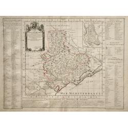
LA PROVENCE Divisée en ses Vigueries et Terres Adjacentes.
Detailed map of southern France. Showing the cities of Marseille, St.Tropez, Cannes, Nice, Antibes, Aix, Orange, Barcelonette, Senez., and Monaco, etc.Detailed map by one...
Date: Paris, 1707
Selling price: ????
Please login to see price!
Sold
La Lorraine.
Alexis-Hubert Jaillot (1632-1712), French cartographer. he joined the Sanson heirs. He redrew Nicolas Sanson's maps on a larger scale. 'Atlas Nouveau' (1674), sea-atlas '...
Date: Paris, 1707
Selling price: ????
Please login to see price!
Sold in 2019
Carte du Diocese de Beziers ...
Beautiful copper engraved map of the diocese of Béziers, France, drawn up on the spot by Gautier, engineer and architect of the province of Languedoc, and dedicated to C...
Date: Paris, 1708
Selling price: ????
Please login to see price!
Sold in 2019
Carte du Diocese de Beziers.
Map of the Beziers and Languedoc regions of southwestern France by French cartographer de L'Isle. Includes indexes on both sides of the map, and a decorative cartouche in...
Date: Paris, 1708
Selling price: ????
Please login to see price!
Sold in 2010
Carte du Diocese de Beziers.
An important early map of South Western France featuring the region of Languedoc that occuties a portion of the French Riviera. The top right corner features a town plan ...
Date: Amsterdam, 1708
Selling price: ????
Please login to see price!
Sold in 2015

Carte du Duche de Bourgogne et des Comtez en Dependans.
An attractive 1709 map of Burgundy (Bourgogne), France, the popular wine producing region, covering the southern part of the region from Dole south as far as Pont-de-Veyl...
Date: Paris, 1709
Selling price: ????
Please login to see price!
Sold in 2023
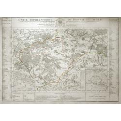
Carte Topographique du Diocese de Senlis.
Map of region surrounding the medieval town of Senlis, in the Picardy region of north-central France. Senlis is an ancient city going back to Roman times, and the monarch...
Date: Paris, 1709
Selling price: ????
Please login to see price!
Sold in 2010
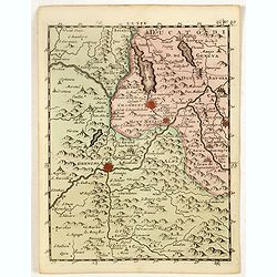
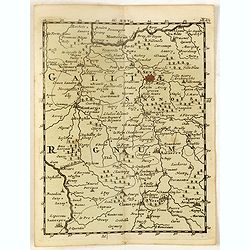
(Chambery, Mon Melian, Grenoble, etc.)
Rare miniature map including the towns of Chambery, Mon Melian, Grenoble, etc. From "Le theatre De Bellone, Contenant 48. nouvelles Cartes Geographiques, Des Païs-B...
Date: Amsterdam, 1710
Selling price: ????
Please login to see price!
Sold in 2018
(Brisach, Basel, Montbelgard, etc.)
Rare miniature map including the towns of Brisach, Basel, Montbelgard,, etc. From "Le theatre De Bellone, Contenant 48. nouvelles Cartes Geographiques, Des Païs-Bas...
Date: Amsterdam, 1710
Selling price: ????
Please login to see price!
Sold in 2016
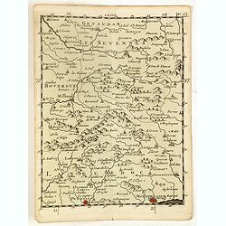
(Les Sevennes, Montpellier, Pezenas, etc.)
Rare miniature map including the towns of Les Sevennes, Montpellier, Pezenas, etc. From "Le theatre De Bellone, Contenant 48. nouvelles Cartes Geographiques, Des Pa�...
Date: Amsterdam, 1710
Selling price: ????
Please login to see price!
Sold in 2020

(La Duché de Bourgogne, Troyes, Dion, etc.)
Rare miniature map of La Duché de Bourgogne, including the towns of Troyes, Dion, etc. From "Le theatre De Bellone, Contenant 48. nouvelles Cartes Geographiques, De...
Date: Amsterdam, 1710
Selling price: ????
Please login to see price!
Sold in 2017
(Sens, Auxerre, Montargis, etc.)
Rare miniature map including the towns of Sens, Auxerre, Montargis, etc. From "Le theatre De Bellone, Contenant 48. nouvelles Cartes Geographiques, Des Païs-Bas Esp...
Date: Amsterdam, 1710
Selling price: ????
Please login to see price!
Sold in 2016
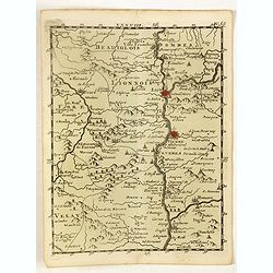
(Lyon, Vienne, Valence, etc.)
Rare miniature map including the towns of Lyon, Vienne, Valence, etc. From "Le theatre De Bellone, Contenant 48. nouvelles Cartes Geographiques, Des Païs-Bas Espagn...
Date: Amsterdam, 1710
Selling price: ????
Please login to see price!
Sold in 2018
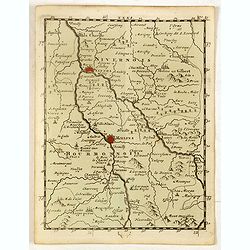
(Neyers, Moulins, Mont Morillon, etc.)
Rare miniature map including the towns of Neyers, Moulins, Mont Morillon, etc. From "Le theatre De Bellone, Contenant 48. nouvelles Cartes Geographiques, Des Païs-B...
Date: Amsterdam, 1710
Selling price: ????
Please login to see price!
Sold in 2016
Carte du Diocese de Beauvais.
Map of the Roman Catholic Diocese of Beauvais, in north central France. The town of Beauvais, the seat of the seat of the Diocese, and home to the beautiful gothic cathed...
Date: Paris, 1710
Selling price: ????
Please login to see price!
Sold in 2010
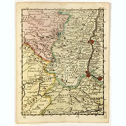
(Embrun, Gap, Sisteron, etc.)
Rare miniature map including the towns of Embrun, Gap, Sisteron, etc. From "Le theatre De Bellone, Contenant 48. nouvelles Cartes Geographiques, Des Païs-Bas Espagn...
Date: Amsterdam, 1710
Selling price: ????
Please login to see price!
Sold in 2020
(Cisteaux, Challon sur Saone, Charolles, etc.)
Rare miniature map including the towns of Cisteaux, Challon sur Saone, Charolles, etc. From "Le theatre De Bellone, Contenant 48. nouvelles Cartes Geographiques, Des...
Date: Amsterdam, 1710
Selling price: ????
Please login to see price!
Sold in 2018
(Pinerolo, Brueil, Antibe, Monaco, etc.)
Rare miniature map including the towns of Pinerolo, Brueil, Antibe, Monaco, etc. From "Le theatre De Bellone, Contenant 48. nouvelles Cartes Geographiques, Des Païs...
Date: Amsterdam, 1710
Selling price: ????
Please login to see price!
Sold in 2020
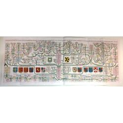
Carte généalogique de la maison de Plantagenette et des ducs Normandie avec les branches, et les alliances quelles, ont formées; pour conduire a l'intelligence de l'histoire d'Angleterre et d'Ecosse et d'Irlande.
A very attractive, hand colored genealogical chart of mediaeval English royal families, including thirteen coats of arms of Edward the Confessor, Edward III, the Plantage...
Date: Paris, 1711
Selling price: ????
Please login to see price!
Sold in 2015
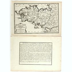
Gouvernement général du Duché de Bretagne, Divisée en Haute et Basse.
First state. Separation in Upper and Lower Brittany as shown on the 1705 plate is now corrected.
Date: Paris, 1711
Selling price: ????
Please login to see price!
Sold in 2015
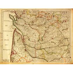
Carte du Bourdelois du Perigord et des Provinces voisines.
Guillaume de l' Isle (1675-1724), Royal Geographer, was the most influential cartographer of the first quarter of the 18th century. 'Atlas de Géographie' (1700-12), post...
Date: Paris, 1712
Selling price: ????
Please login to see price!
Sold
Provincia Normaniae.
Scarce map of Normandy, extending from the Channel Islands to Paris. Published in Montecalerio's "Chorographica descriptio Provinciarum et Conventuum Fratrum minorum...
Date: Rome, 1643-1712
Selling price: ????
Please login to see price!
Sold in 2016
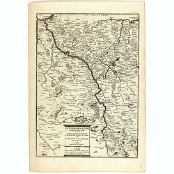
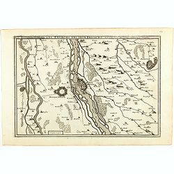
Partie Meridionale de Picardie
Finely detailed map of the Picardy region of northwestern France., including the regional capital of Amiens in the center of the map. A map key is in the bottom left corn...
Date: Paris, 1712
Selling price: ????
Please login to see price!
Sold in 2010
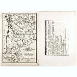
Carte du Bearn de la Bigorre de L'Armagna et des Pays Voisins.
Map of the Pyrenees Mountains regions of France and Spain. Depicts the regions of Aquitaine and Midi-Pyrenees in France and Navarra in Spain. Also, shows abbeys by religi...
Date: Paris, 1712
Selling price: ????
Please login to see price!
Sold in 2010
Prova Parisiensis...
Scarce map centred on Paris and extending from Calais to Auxerre, and east until Metz. Published in Montecalerio's "Chorographica descriptio Provinciarum et Conventu...
Date: Rome, 1643-1712
Selling price: ????
Please login to see price!
Sold in 2016
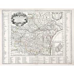
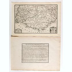
Partie Meridionale de Champagne.
A very detailed map of the Champagne region in France by Guillaume De L'Isle. Major cities such as Provins and Chatillon are included as well as major rivers, lakes and f...
Date: Paris, 1713
Selling price: ????
Please login to see price!
Sold in 2010
Parte Meridionale de Champagne.
Map of northeastern France centered on the southern Champagne region. The map includes other surrounding regions including Brie, Burgundy, Lorraine and Berry, and numerou...
Date: Paris, 1713
Selling price: ????
Please login to see price!
Sold in 2010
