Browse Listings in Europe > British Isles
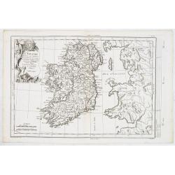
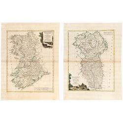
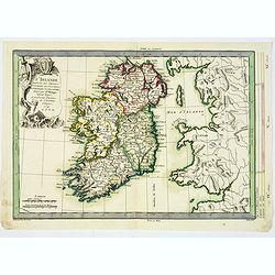
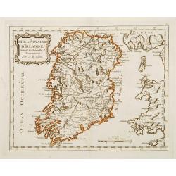
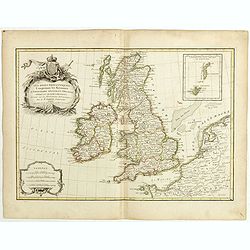
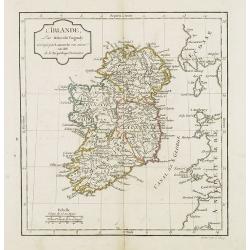
L'Irlande. . .
Fine detailed and uncommon map of Ireland. Prepared by Etienne André Philippe de Pretot (1708-1787) a royal censor and professor of history at the Royal Academy of Scien...
Date: Paris, 1770
Selling price: ????
Please login to see price!
Sold in 2013
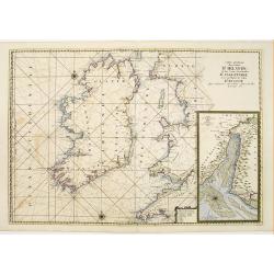
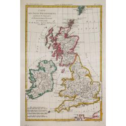
Carte Generale des Costes D'Irelande et des Costes..d'Angleterre avec une Partie de celles D'Ecosse..
Attractive chart. Whole of Ireland and England from Ayr to Plymouth. Large scale inset of the Dee estuary up to Chester in decorative frame. Latitude and longitude scales...
Date: Paris 1770
Selling price: ????
Please login to see price!
Sold
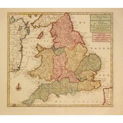
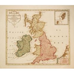
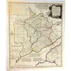
Nieuwe Kaaart van 't Zuider Gedeelte van Groot Britannie behelsende Het Koningryk Engeland.
Izaak Tirion (d. 1769) Amsterdam publisher. His ' Nieuwe en beknopte handatlas' saw 6 editions between before 1740 and after 1784. Also ' Tegenwoordige staat van alle vol...
Date: Amsterdam, c. 1770
Selling price: ????
Please login to see price!
Sold in 2020
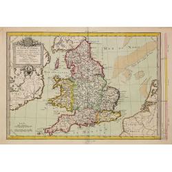
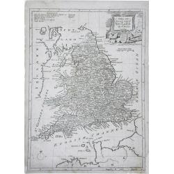
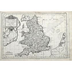
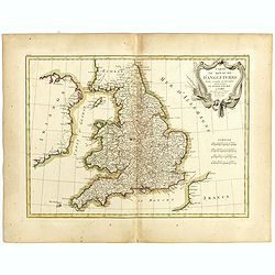
L'Angleterre..
Fine detailed and uncommon map of England. Prepared by Etienne André Philippe de Pretot (1708-1787) a royal censor and professor of history at the Royal Academy of Scien...
Date: Paris, 1770
Selling price: ????
Please login to see price!
Sold in 2011
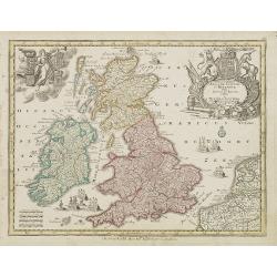
Nieuwe Kaart van de Eilanden van Groot Brittannien behelzende de Koningryken Engeland, Scotland en ierland.
Izaak Tirion (d. 1769) Amsterdam publisher. His ' Nieuwe en beknopte handatlas' saw 6 editions between before 1740 and after 1784. Also ' Tegenwoordige staat van alle vol...
Date: Amsterdam, c. 1770
Selling price: ????
Please login to see price!
Sold in 2010
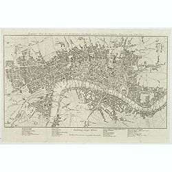
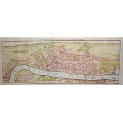
Accurater Plan der Stadt London nebst Westminster, Southwark und den neu angebauteten Haeusern vom Jahr 1767.
Uncommon plan of London with Hyde Park, Sadlers Wells, Mile End, Newington Butts. Underneath the plan a translation of English words used in the map into German below.Sig...
Date: Berlin, 1770
Selling price: ????
Please login to see price!
Sold in 2012
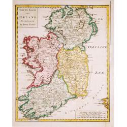
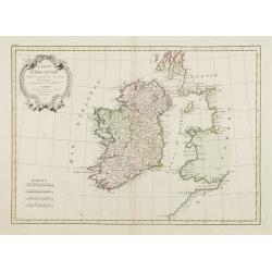
Nieuwe Kaart van Ierland.
28Izaak Tirion (d. 1769) Amsterdam publisher. His ' Nieuwe en beknopte handatlas' saw 6 editions between before 1740 and after 1784. Also ' Tegenwoordige staat van alle v...
Date: Amsterdam, c. 1770
Selling price: ????
Please login to see price!
Sold in 2015
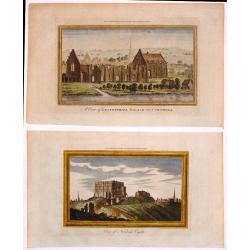
Two Hand-Colored Views of the Ruins of Ancient British Castles.
Two hand-colored views of English castles including: - "View of Norwich Castle" & - "A View of Lestwithiel Palace in Cornwall" These are copper ...
Date: London, 1770
Selling price: ????
Please login to see price!
Sold in 2018
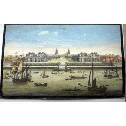
A View of the Royal Hospital at Greenwich.
An optical print of the Christopher Wren Old Royal Naval College from the Thames.
Date: London, circa 1770
Selling price: ????
Please login to see price!
Sold in 2022
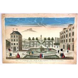
Vue et Perspective d'Une Jardin du Roy d'Angleterre aux Environs de Londres.
A hand colored optical print of the King's garden in London, published in Paris by Basset in about 1770. During the 18th century there were several manufacturers of optic...
Date: Paris, ca. 1770
Selling price: ????
Please login to see price!
Sold in 2018
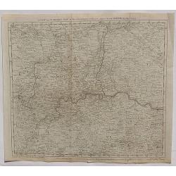
A New and Correct Map of the Countries twenty Miles Round London.
A detailed map of the counties within 20 miles around London by Bowen in 1770. Thomas Bowen (1733-1790) was the son of Emanuel Bowen and became a map maker, engraver and ...
Date: London, 1770
Selling price: ????
Please login to see price!
Sold in 2020
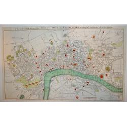
A New and Accurate Plan of the Cities of London and Westminster, including the New Roads & Buildings.
A large, attractive and nicely detailed plan of London as seen in the early 1770?s. A scarce piece.John Andrews produced only a small number of works and is primarily rec...
Date: London, c. 1772
Selling price: ????
Please login to see price!
Sold
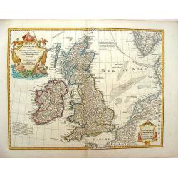
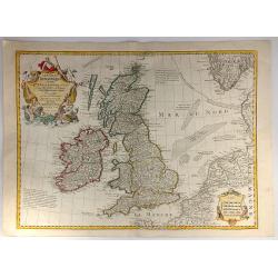
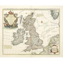
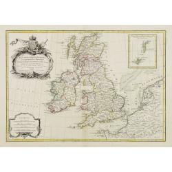
Les Isles Britanniques ou Sont le Royaumes d\'Angleterre .
Showing the British Isles and Ireland. It was published by Phillipe Buache in France in 1772. The map features two large Renaissance cartouches. Guillaume de l'Isle (167...
Date: Paris, 1772
Selling price: ????
Please login to see price!
Sold in 2013
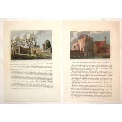
(2 Engravings) The Chapel of St. Pancrace, in St. Augustine's Monastery, Canterbury & The Great hall of the Archbishop's Palace, Canterbury
Two hand-colored, copper engravings of Canterbury architecture from Grose's "The Antiquities of England and Wales". Includes text concerning the location on the...
Date: London, 1772
Selling price: ????
Please login to see price!
Sold in 2016
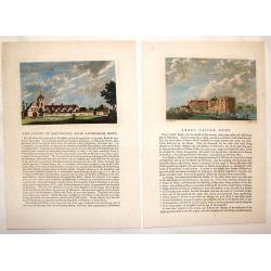
(2 Engravings) Leeds Castle, Kent & The Priory of Davyngton, Neat Faversham, Kent.
Two hand-colored, copper engravings featuring antique architectural buildings in Kent. These Prints are from Grose's "The Antiquities of England & Wales" an...
Date: London, 1772
Selling price: ????
Please login to see price!
Sold in 2016
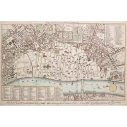
A PLAN OF THE CITY AND LIBERTIES OF LONDON; SHEWING THE EXTENT OF THE DREADFUL CONFLAGRATION IN THE YEAR 1666.
Based on Wenceslaus Hollar's 1666 map of the Great Fire of London. A highly detailed map of the City of London and its environs, designed to show the vast extent of the G...
Date: London, 1772
Selling price: ????
Please login to see price!
Sold in 2015
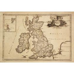
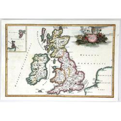
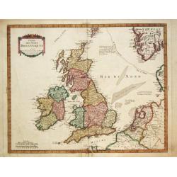
Les Isles Britanniques ou sont le Rme. d'Angleterre Tire de Sped Celuy d'Ecosse...
Originally issued in 1702 by Delisle, this influential map of the British Isles map has his characteristic crisp style and topographical detail. On the right hand side th...
Date: Paris, 1772
Selling price: ????
Please login to see price!
Sold in 2016
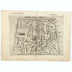
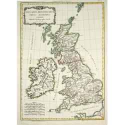
Insularum Britannicarum Facies Antiqua.
Christoforus Cellearius (1638-1707), geographer. ' Geographia Antiqua', 1686-1812
Date: Leipzig, 1773
Selling price: ????
Please login to see price!
Sold in 2008
NEW MAP OF THE CITY OF OXFORD
A scarce 18th century plan of the City of Oxford. The work is finely rendered and contains exceptional detail. Three separate legends identify important town sites. Unive...
Date: London, dated 1773
Selling price: ????
Please login to see price!
Sold
Insularum Britannicarum Facies Antiqua
A fine copperplate map of ancient Britain by Christophorus Cellarius in 1773. The Orkney and Shetland islands are shown in an insert at the top left corner. The decorativ...
Date: Leipzig, 1773
Selling price: ????
Please login to see price!
Sold in 2019
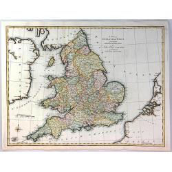
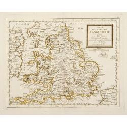
A Map of England and Wales from the Latest Authorities and Observations
A fine map of England and Wales by John Blair L.L.D. & F.R.S. issued as a Supplement to his Tables of Chronology. The Counties of England, and Wales are all separatel...
Date: London, 1773
Selling price: ????
Please login to see price!
Sold in 2018
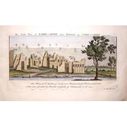
The South View of Easby Abbey near Richmond in York, 1721.
Landscape view of historic castle in Great Britain, original engraved in the early 18th century, and reissued in 1774 as part of a set popularly known as Buck's Antiquiti...
Date: London, 1774
Selling price: ????
Please login to see price!
Sold in 2018
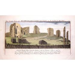
The South View of Knaresborough Castle in Yorkshire, 1721.
Landscape views of historic castles in Great Britain, originally engraved in the early 18th century, and reissued in 1774 as part of Antiquities, a compendium of views of...
Date: London, 1774
Selling price: ????
Please login to see price!
Sold in 2019
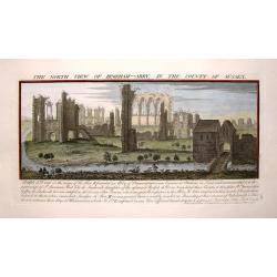
The North view of Begeham Abbey, in the County of Sussex.
Landscape view of historic castle in Great Britain, original engraved in the early 18th century, and reissued in 1774 as part of a set popularly known as Buck's Antiquiti...
Date: London, 1774
Selling price: ????
Please login to see price!
Sold in 2017
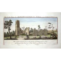
The South View of Harlsey Castle Near N. Allerton in Yorkshire, 1721.
Landscape view of historic castle in Great Britain, original engraved in the early 18th century, and reissued in 1774 as part of a set popularly known as Buck's Antiquiti...
Date: London, 1774
Selling price: ????
Please login to see price!
Sold in 2018
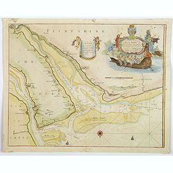
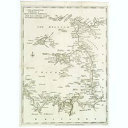
A New and Exact Survey of the River Dee or Chester-Water. . .
An English sea chart by Grenville Collins, depicting (in part) the coastlines and sands of The Wirral, Cheshire, Lancashire and Flintshire, and the River Dee estuary. The...
Date: London, ca 1774
Selling price: ????
Please login to see price!
Sold in 2020
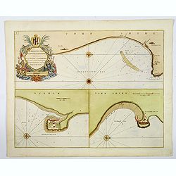
Burlington Bay, Scarborough & Hartlepool.
An impressive sea chart of the north England areas of Hartlepool, Scarborough and Burlington Bay. From Greenville Collins, the Hydrographer to the King (George III), from...
Date: London, ca 1774
Selling price: ????
Please login to see price!
Sold in 2019
Itinéraire anglois containing the great, direct and cross roads, through England and Wales. . .
Uncommon and detailed map of England and Wales.
Date: London, Sayer and Bennett, 1775
Selling price: ????
Please login to see price!
Sold in 2011
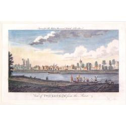
View of Twickenham from the River.
A playful river view of the village of Twickenhan in Middlesex. In th e foreground is the River Thames with two pleasure craft.
Date: London, 1775
Selling price: ????
Please login to see price!
Sold in 2019
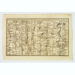
The Road from London to Barnstable, in Devonshire, commencing at Andover, in the road to the Lands End, also from Barnstable to Truro.
A highly detailed late eighteenth century road map, running left to right, commencing at Andover in Hampshire and continuing on to Barnstable in north Devonshire. The map...
Date: London, 1775
Selling price: ????
Please login to see price!
Sold in 2026
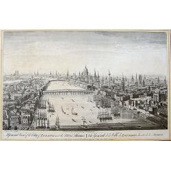
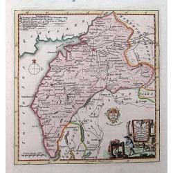
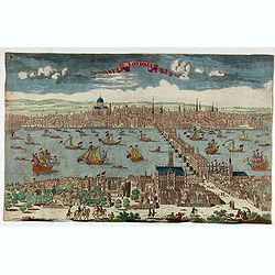
A General View of the City of London, next the River Thames | Vue Generale de la Ville de Londres, du côté de la Tamise.
Rare bird's eye view of London with an imense amount of details, buildings, ships, etc. Shows the Tower on the right, old London Bridge in the centre with the Monument to...
Date: London, 1775
Selling price: ????
Please login to see price!
Sold in 2019
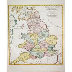
Brittanniae Antiquae Tabula Geographica.
John Horsley's map of antique England, published in ' A Complete Body of Ancient Geography'.
Date: London, R. Sayer and J. Bennett, 1777
Selling price: ????
Please login to see price!
Sold in 2011
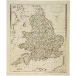
A New and Accurate Map of England. . .
A finely detailed, small scale map of England by Thomas Bowen. Emmanuel Bowen was one of the leading English mapmakers of the eighteenth-century, and was cartographer to ...
Date: London, c.1777
Selling price: ????
Please login to see price!
Sold in 2010
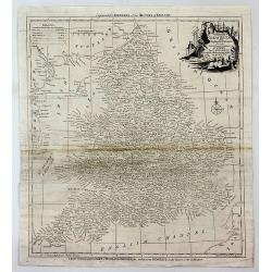
An Accurate Map of the County of Monmouth, Divided Into Hundreds
This attractive map of the county of Monmouth identifies major roads, villages, churches, and castles, it is by Emanuel Bowen, and was published for Robert Sayer in Londo...
Date: London, 1777
Selling price: ????
Please login to see price!
Sold in 2017
Accuratiffima Angliae Scotiae et Hiberniae. . .
Miniature map of the United Kingdom with Scotland and Ireland, a reduction of Seutter''s folio map.From Atlas Minor, here published by Johann Martin Will, with his addres...
Date: Augsburg, J.M.Will, 1778
Selling price: ????
Please login to see price!
Sold in 2023
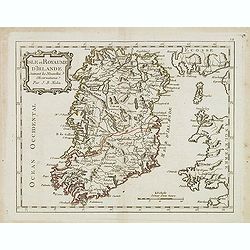
(IRELAND). Parte Del Regno D'Irlanda, cioe' Le Provincie D'Ulster, E Leinster. / Parte Del Regno D'Irlanda, cio+¿ Le Provincie Di Connaught, E Munster Di Nuova Projezione.
Together 2 sheets. Each image c. 31 x 41 cm. Original outline color, both with decorative colored title cartouches. Ireland shown on two double page maps. The first map s...
Date: Venice: Antonio Zatta. 1778
Selling price: ????
Please login to see price!
Sold in 2020
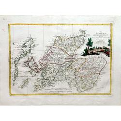
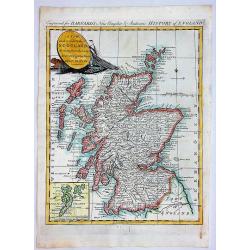
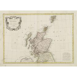
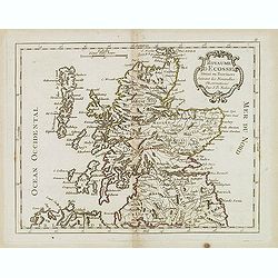
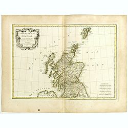
La Scozia Settentrionale Divisa Nelle Sue Contee Particolari
This is a top half of a two sheet map of Scotland showing northern Scotland by Antonio Zatta, engraved by Pitteri. Shows regions of Strathnavern, Ross-shire, Inverness, M...
Date: Venice, 1779
Selling price: ????
Please login to see price!
Sold in 2010
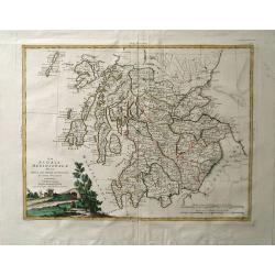
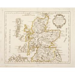
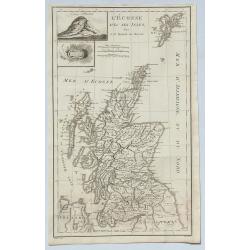
La Scozia Meridionale divisa Nelle sue Contee Particolari di Nuova Projezione.
A detailed map of regions in Scotland by Antonio Zatta. Depicts major cities such as Carrick, Galloway, and Perth, and major river systems in the area. This map also show...
Date: Venice, 1779
Selling price: ????
Please login to see price!
Sold in 2010
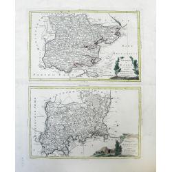
Provincia di Essex di nuova Projezione / Provincia di Middlesex di nuova Projezione. . .
Maps of Essex county (top) and Middlesex county (bottom), a former county, both located in the Southeast Greater London region by Antonio Zatta. The cities of Kingston an...
Date: Venice, 1779
Selling price: ????
Please login to see price!
Sold in 2010
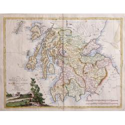
La Scoza Meridionale Divisa Nelle Sue Contee Particolari Di Nuova Projezionev Venezia 1779 Autonio Zatta
Attractive map of Southern Scotland by Antonio Zatta engraved by Giovanni Marco Pitteri one of Italy’s greatest engravers.A copper engraving with beautiful hand colorin...
Date: Venice, 1779
Selling price: ????
Please login to see price!
Sold in 2018
![A map of the Kingdom of Ireland showing the archbishopricks, bishopricks, cities, boroughs, market towns, villages, barracks, mountains [. . .] by J. Rocque, chorographer to His Majesty.](/uploads/cache/92786-250x250.jpg)
A map of the Kingdom of Ireland showing the archbishopricks, bishopricks, cities, boroughs, market towns, villages, barracks, mountains [. . .] by J. Rocque, chorographer to His Majesty.
A dramatic large four sheet map, (here on two joined sheets) from Sayer's large Atlas of 1779.Rocque was Topographer to the Prince of Wales and attained his new title aft...
Date: London, 1779
Selling price: ????
Please login to see price!
Sold in 2015
L'Irlande. . .
An attractive map of Ireland, prepared by M. Philippe, embellished with a decorative title cartouche. Drawn and engraved by Vallet and Moithey. With a scale of miles, and...
Date: Paris, 1779
Selling price: ????
Please login to see price!
Sold in 2018
L'Angleterre... par Mr. Philippe. . .
An unusual copper engraved map of England, also showing parts of Ireland. Filled with places names in England. Decorative title cartouche. With a curious climatalogical s...
Date: Paris, 1779
Selling price: ????
Please login to see price!
Sold in 2020
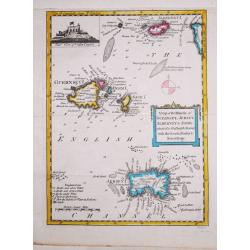
Antique map of the Channel Islands.
A nice antique map of the Channel Islands, published in the English Gentleman's Magazine. Inset at top left of Cornet Castle. Mileage scale.
Date: London, 1779
Selling price: ????
Please login to see price!
Sold in 2020
London and Westminster in the Reign of Queen Elizabeth Anno Dom 1563.
A rare 18th century pull out town plan of London, as it was known during the time of Elizabeth I. This work is very much patterned after the famous first large scale plan...
Date: London, 1780
Selling price: ????
Please login to see price!
Sold
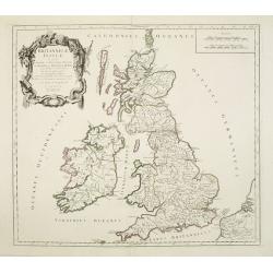
Carte des Isles Britanniques.
Rigobert Bonne (1727-1795), French cartographer. His maps are found in a.o. Atlas Moderne (1762), Raynal's Histoire Philos. du Commerce des Indes (1774) and Atlas Encyclo...
Date: Paris, c. 1780
Selling price: ????
Please login to see price!
Sold in 2018
Magnae Britanniae Tabula, comprehendens Angliae, Scotiae ac Hiberniae.
The 1702 Delisle general map of the British Isles, copied by Pierre Mortier in 1702 and here in a second state with the address of Jean Covens and Cornelis Mortier.The Am...
Date: Amsterdam, ca. 1780
Selling price: ????
Please login to see price!
Sold in 2010
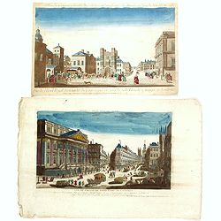
A View of the Royal Exchange , London. Vue de la bourse royal a Londres. . .
So-called optical print of London with a view of Cornhill and the Exchange, with St. Paul's visible in the distance - horse-drawn traffic laboring along the road.The imag...
Date: Paris, ca. 1780
Selling price: ????
Please login to see price!
Sold in 2023
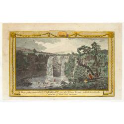
View of the Remarkable Cataract on the River Teese, Which Divides the Counties of York and Durham.
Fine hand-colored, copper engraved print of an inviting view of a waterfall being viewed by two spectators and two fishermen. The print was engraved for "The Complet...
Date: London, c. 1780
Selling price: ????
Please login to see price!
Sold in 2015
Two opticals of London.
Two optical prints of London, being : "Vue de l'Hotel Royal des Gardes du Corps a pied vis a' vis la Salle Blanche a manger a Londres" and "Vue de L'Hotel ...
Date: Paris c.1780
Selling price: ????
Please login to see price!
Sold in 2016
Cumberland drawn from the best surveys,...
An attractive and finely engraved 18th century map of Cumberland. Main cities are shown connected with roads. Borough towns and market towns are indicated, as well as par...
Date: London, ca. 1780
Selling price: ????
Please login to see price!
Sold in 2016
Accurate Map of That District of Great Britain Called England & Wales...
A very detailed map of Great Britain by Thomas Kitchin, from Walpoole's New & Complete British Traveller, published in 1784.The map shows the counties and identifies ...
Date: London, ca. 1780
Selling price: ????
Please login to see price!
Sold in 2017
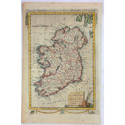
A New and Correct Map of Ireland from the Latest Surveys of That Kingdom.
A fine detailed map of Ireland by John Hamilton Moore in London in 1780. It is from "MOORE'S NEW AND COMPLETE COLLECTION OF VOYAGES AND TRAVELS". Engraved for B...
Date: London, 1780
Selling price: ????
Please login to see price!
Sold in 2019
Londres.
Decorative print of London.
Date: Paris, ca. 1780
Selling price: ????
Please login to see price!
Sold in 2022
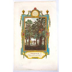
Charles II Concealed in the Oak.
Interesting hand-colored copper engraving from "RUSSELL'S HISTORY OF ENGLAND" in 1781. It was engraved by White after a picture by Wade.
Date: London, 1781
Selling price: ????
Please login to see price!
Sold in 2016
The Roads of Great Britain. Itineraire de la Grande Bretagne. Published as the Act directs Jan 1st 1781 By William Faden Succr to the late T Jefferys Geographer to the King, Charing Cross
A rare example of Faden's desirable folding map 'Roads of Great Britain' in its first edition of 1781.Covering from Scotland to Cornwall, this large pocket map was design...
Date: London, 1781
Selling price: ????
Please login to see price!
Sold in 2017
A New and Correct Chart of the Islands of Jersey, Guernsey, Alderney...
A detailed map of the Channel Islands, and sections of Brittany and Normandy, from the Neville to the Isles of Brehat. Included in the Political Magazine , engraved by Lo...
Date: London 1781
Selling price: ????
Please login to see price!
Sold in 2016
A New and Correct Map of SCOTLAND, Drawn from the Latest Surveys of that Party of Great Britain.
A fine copperplate map from “Barnard's New Complete and Authentic History of England”, published in London by Edward Barnard in 1781-1783.It features a marine cartouc...
Date: London, 1781
Selling price: ????
Please login to see price!
Sold in 2019
Carte du Royaume de l'Angleterre divisé par Provinces, Schires ou Comtés ..
Rare map of England prepared after J.B.Nolin and published by Monhare for his Atlas Général a l'usage des colleges et maisons d'education.. Louis Joseph Mondhare publis...
Date: Paris 1783
Selling price: ????
Please login to see price!
Sold
Royaume d'Ecosse Divisé en Provinces . . .
Rare map of Scotland prepared by J.B.Nolin and published by Monhare for his Atlas Général a l'usage des colleges et maisons d'education.. Louis Joseph Mondhare publishe...
Date: Paris, 1783
Selling price: ????
Please login to see price!
Sold in 2016
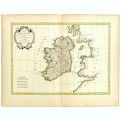
Isle et Royaume D'Irlande ..
Rare map of Ireland prepared by J.B.Nolin and published by Monhare for his Atlas Général a l'usage des colleges et maisons d'education.. Louis Joseph Mondhare published...
Date: Paris 1783
Selling price: ????
Please login to see price!
Sold
Insularum Britannicarum Tabula Geographica.
Jean Lattré, Paris-based engraver and publisher. Worked with Robert de Vaugondy, J. Janvier and R. Bonne. " Atlas Monderne', 1771, 1783 , 1793. Rigobert Bonne (1727...
Date: Paris, 1783
Selling price: ????
Please login to see price!
Sold in 2011
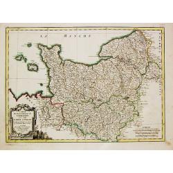
Carte du Gouvernement de Normandie avec celui du Maine et Perche.
Jean Lattré, Paris-based engraver and publisher. Worked with Robert de Vaugondy, J. Janvier and R. Bonne. "Atlas Monderne", 1771, 1783 , 1793. Rigobert Bonne (...
Date: Paris, 1783
Selling price: ????
Please login to see price!
Sold in 2018
Carte Du Royame D'Ecosse..
Attractive map of Scotland, including the Shetland Islands. Decorated with a rococo title cartouche. Boundaries outlined in hand color.From theAtlas moderne ou collection...
Date: Paris, ca 1783
Selling price: ????
Please login to see price!
Sold
Carte D'Irlande..
Attractive map of Ireland, ornated with a rococo title cartouche. Boundaries outlined in hand color.From theAtlas moderne ou collection de cartes sur toutes les parties d...
Date: Paris, ca 1783
Selling price: ????
Please login to see price!
Sold
Les isles Britanniques comprenant les Royaumes d\'Angleterre d\'Ecosse et d\'Irlande..
Attractive map of the British Isles, ornated with a decorative title cartouche and a scale cartouche.With inset map including the Orcade and Shetland Islands. Boundaries ...
Date: Paris, ca 1783
Selling price: ????
Please login to see price!
Sold in 2008
Royaume d'Ecosse. . .
Scarce map of Scotland prepared by Nolin and published by L.J. Mondhare for his Atlas Général a l'usage des colleges et maisons d'education.. Louis Joseph Mondhare was ...
Date: Paris, 1783
Selling price: ????
Please login to see price!
Sold in 2013
Isle et Royaume d'Irlande. . .
Scarce map of Ireland prepared by Nolin and published by L.J. Mondhare for his Atlas Général a l'usage des colleges et maisons d'education.. Louis Joseph Mondhare was a...
Date: Paris, 1783
Selling price: ????
Please login to see price!
Sold in 2016
Carte d'Irlande Projettée et assujettie aux Observations Astronomiques. . .
Attractive map of Ireland, ornated with a decorative title cartouche. Boundaries outlined in hand color.Prepared by Le Sieur Janvier, Jean Denis [Robert], French geograph...
Date: Paris, ca 1783
Selling price: ????
Please login to see price!
Sold in 2019
Les Isles Britanniques comprenant les Royaumes d'Angleterre, d'Ecosse et d'Irlande . . .
Attractive map of the British isles, ornated with a decorative title cartouche. Boundaries outlined in hand color.Prepared by Le Sieur Janvier, Jean Denis [Robert], Frenc...
Date: Paris, ca 1783
Selling price: ????
Please login to see price!
Sold in 2019
Carte du Royaume d'Angleterre . . .
Attractive map of the United Kingdom, ornated with a decorative title cartouche. Boundaries outlined in hand color.Prepared by Le Sieur Janvier, Jean Denis [Robert], Fren...
Date: Paris, ca 1783
Selling price: ????
Please login to see price!
Sold in 2019
Carte du Royaume d'Ecosse . . .
Attractive map of Scotland, ornated with a decorative title cartouche. Boundaries outlined in hand color.Prepared by Le Sieur Janvier, Jean Denis [Robert], French geograp...
Date: Paris, ca 1783
Selling price: ????
Please login to see price!
Sold in 2019
L'Ecosse avec ses Isles.
A decorative antique map of Scotland and islands, with two inlays of Craig Phadrich forested hill. It was published by Barbie and engraved by Doudan.Jean-Denis Barbié, k...
Date: Paris, 1783
Selling price: ????
Please login to see price!
Sold in 2023
Carte des Isles Britanniques
Pierre Bourgoin, Paris-based engraver and publisher. Published in 1784 his uncommon ' Atlas Élémentaire de la Géographie'.Decorative map of the British Isles extending...
Date: Paris, 1784
Selling price: ????
Please login to see price!
Sold in 2011
Britannicae Insulae in quibus Albion.. Et Ivernia..
Map of the British Isles. Ornated with a rococo title cartouche in the upper left corner.Venetian edition of Giles Didier Robert De Vaugondy's map based on Sanson. From &...
Date: Venice, 1776 - 1784
Selling price: ????
Please login to see price!
Sold in 2008
L'Irlande.
A third state with simplified title cartouche and changed text: Corrigée par Lamarche son succes. An IIIe de la République Françaïse. Sponberg does not mention this v...
Date: Paris, 1784
Selling price: ????
Please login to see price!
Sold in 2022

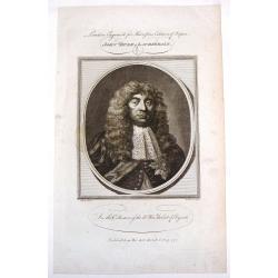
Mr. Rapin de Thoyras.
Fine copper engraving of Mr. Rapin de Thoyras (1661-1725) that was the frontpiece for "Harrison's Edition of Rapin's History of England". Adorned by a fancy eng...
Date: London, 1784
Selling price: ????
Please login to see price!
Sold in 2014
John, Duke of Lauderdale.
Fine copper engraving of John, Duke of Lauderdale from "Harrison's Edition of Rapin's History of England". Engraved by John Goldar from a painting by J. Brande...
Date: London, 1784
Selling price: ????
Please login to see price!
Sold in 2015
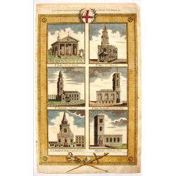
English Cathedrals - St. Paul's, St. Mary, St. Clement's.
Lovely hand-colored copper engraving featuring six English cathedrals including St. Pauls's - Covent Gardens, St. Mary - Le Strand, St. Clement's - Strand, St. Mary Wooln...
Date: London, 1784
Selling price: ????
Please login to see price!
Sold in 2015
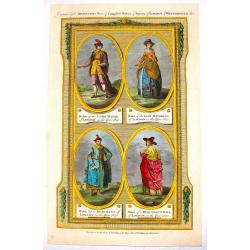
(Four Fashion Prints of London in 1640).
This fine hand-colored copper engraving is from "THORTON'S NEW & COMPLETE HOSTORY & SURVEY OF LONDON & WESTINSTER", published in London by Alex Hogg...
Date: London, 1784
Selling price: ????
Please login to see price!
Sold in 2016
