Browse Listings in Europe > British Isles
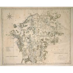
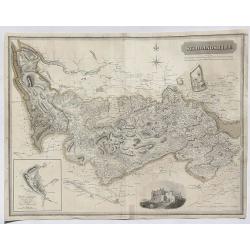
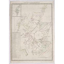
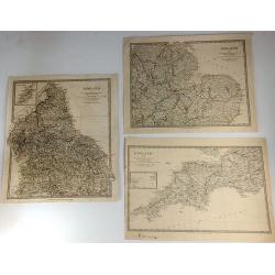
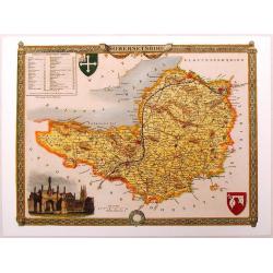
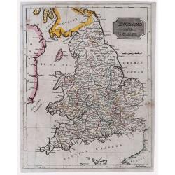
Map of Westmorland from the Best Authorities.
A finely engraved, highly detailed map by Cary, showing Ullswater, Windermere, etc. From Camden's 'Britannia' in 1789. John Cary (1754-1835) was an English cartographer, ...
Date: London, 1805
Selling price: ????
Please login to see price!
Sold in 2019
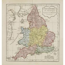
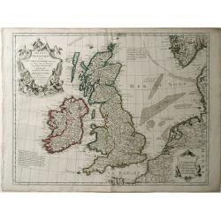
L'Angleterre.
Map of England. By C. F. Delamarche, successor of Robert de Vaugondy, Geographer.
Date: Paris, 1794 - 1806
Selling price: ????
Please login to see price!
Sold in 2011
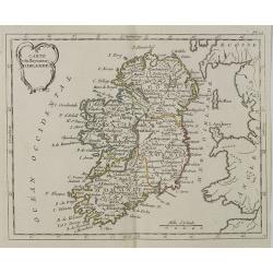
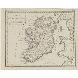
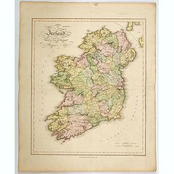
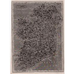
Carte du Royaume d' Irlande . . .
Map of Ireland, from Atlas moderne portatif composé de vingt-huit cartes sur toutes les parties du globe terrestre .. A l'usage des Colléges, des Pensions & des Mai...
Date: Paris, Prudhomme, Levrault, Debray, 1806
Selling price: ????
Please login to see price!
Sold in 2018
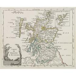
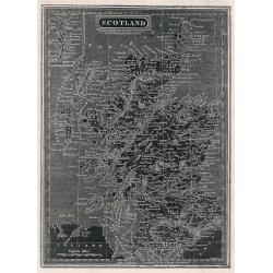
Carte du Royaume d' Ecosse . . .
Map of Scotland from Atlas moderne portatif composé de vingt-huit cartes sur toutes les parties du globe terrestre .. A l'usage des Colléges, des Pensions & des Mai...
Date: Paris, Prudhomme, Levrault, Debray, 1806
Selling price: ????
Please login to see price!
Sold in 2013
Carte du Royaume Unis d'Irlande.
Map of Ireland, from Atlas de la Géographie de toutes les parties du monde.. Ouvrage destiné pour l'education, et nécessaire aux négocians, aux voyageurs, aux fonctio...
Date: Paris, Prudhomme, Levrault, Debray, 1806
Selling price: ????
Please login to see price!
Sold in 2014
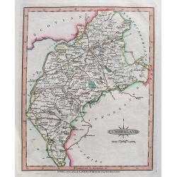
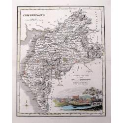
Cumberland.
A detailed map of the area with many towns and villages named, connected by roads. Shows also hills, lakes, and rivers.Includes the "Picts Wall" near Carlisle.
Date: London, 1806
Selling price: ????
Please login to see price!
Sold in 2018
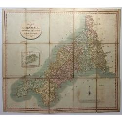
A New Map of Cornwall, Divided into Hundreds Exhibiting Roads, Rivers, Parks &c.
A superbly engraved map of the county of Cornwall by John Cary. From Cary's New English Atlas. The map was mounted on linen, folded and sold in a 7” x 4 ¾” x 3/8” ...
Date: London, 1806
Selling price: ????
Please login to see price!
Sold in 2018
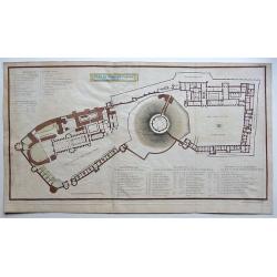
Plan of Windsor Castle MDCCCV.
A very detailed copperplate, plan and gazetteer of Windsor Castle, as it was at the time of The Battle of Trafalgar.Each tower, hall, chamber, ante-room and apartment's n...
Date: London, 1806
Selling price: ????
Please login to see price!
Sold in 2018
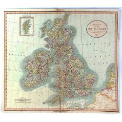
(Two copies of ) Nieuwe kaart van Groot Brittanje en Ierland.
Uncommon map of England and Ireland, printed by François Bohn in Haarlem, who was active from 1786 till 1819. Engraved by C.van Baarsel.
Date: Haarlem 1807
Selling price: ????
Please login to see price!
Sold in 2013
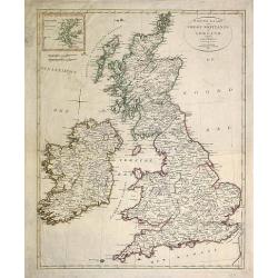
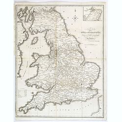
A New Map of the British Isles from the Latest Authorities.
An accurate map of early nineteenth century Great Britain. Two scales at bottom left and title at top right. With an insert of Shetland Islands. All British counties have...
Date: London, 1807
Selling price: ????
Please login to see price!
Sold in 2017
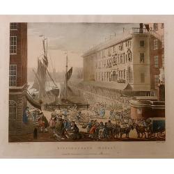
Billingsgate Market, from the Microcosm of London.
A beautiful first edition colored aquatint view of ‘old’ Billingsgate Market, early in the 19th century, where fresh fish were landed and sold directly on the docksid...
Date: London, 1808
Selling price: ????
Please login to see price!
Sold in 2017
Map of the Roman Roads in Britain
Interesting map featuring the comparison of current roads (in 1809) to the ancient Roman roads. It was published by J. White, and the engraver was Neele. I could not find...
Date: London, 1809
Selling price: ????
Please login to see price!
Sold in 2017
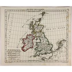
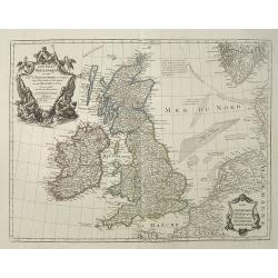
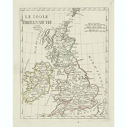
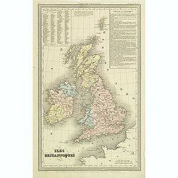
Les Isles Britanniques.
Interesting map of the British Isles engraved on copper by Glot. From the scarce “Atlas Portatif, contenant la G‚ographie Universelle Ancienne et Moderne” by Eustac...
Date: Paris, 1809
Selling price: ????
Please login to see price!
Sold in 2018
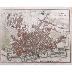
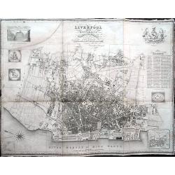
Plan der Stadt Liverpool.
Anonymous copper engraved plan of Liverpool, with German title but printed in Prague. Names numerous streets and buildings, and several docks and yards along the Mersey r...
Date: Prague, 1810
Selling price: ????
Please login to see price!
Sold in 2015
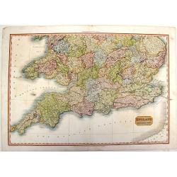
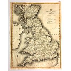
England, Southern Part.
A fine, detailed map of southern England and the English Channel. John Pinkerton (1758 – 1826) was a Scottish antiquarian, cartographer and historian. Pinkerton was a...
Date: London, 1811
Selling price: ????
Please login to see price!
Sold in 2015
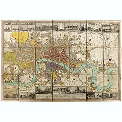
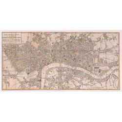
Langley & Belch's New Map of London.
Decorative plan of London, with illustrated views of prominent London buildings (including the newly opened docks) along the top and bottom of the plate. The plan is divi...
Date: London, 1812
Selling price: ????
Please login to see price!
Sold in 2020
A New Pocket Plan of the Cities of London & Westminster with the Borough of Southwark: Comprehending the New Buildings and other Alterations to the Year 1812.
A detailed and well executed plan of central London, showing the extents from Angel down to Lambeth and Mile End across to Knightsbridge. Some very light original color a...
Date: London 1812
Selling price: ????
Please login to see price!
Sold in 2020
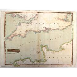
The British Channel.
Fine example of John Thomson’s 1814 map of the English Channel. John Thomson (1777-c1840), was a Scottish cartographer from Edinburgh, celebrated for his 1817 New Gen...
Date: Edinburgh, 1814
Selling price: ????
Please login to see price!
Sold in 2015
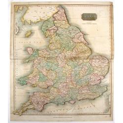
England.
Fine hand-colored, engraved map of England and Wales with Thomson's high level of detail. From "New General Atlas".John Thomson (1777-1840), was a Scottish cart...
Date: Edinburgh, 1814
Selling price: ????
Please login to see price!
Sold in 2016
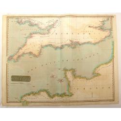
The British Channel.
Fine hand-colored map of the English Channel from John Thomson,s "GENERAL ATLAS" published in 1814. Engraved and signed in print by J & G Menzies.
Date: Edinburgh, 1814
Selling price: ????
Please login to see price!
Sold in 2016
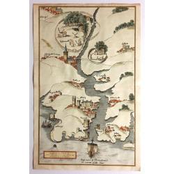
Fowey Haven & C., From a Chart Drawn in the Reign of K. Hen. VIII.
Plan of Fowey Haven. Published by Daniel & Samuel Lysons in 1814. It features views in almost a cartoon style of villages, from a chart of Cornwall, produced during t...
Date: London, 1814
Selling price: ????
Please login to see price!
Sold in 2017
New Map of the City of Dublin For the Year 1816
A hard to find, beautifully rendered plan of Dublin. The work contains wonderful detail, with all streets, major sites and expanses identified. In the lower right corner ...
Date: Dublin, ca. 1816
Selling price: ????
Please login to see price!
Sold in 2009
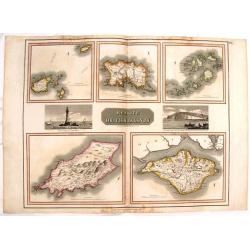
Remote British Islands.
Large, hand-colored map of Great Britain's remote islands including Wight, Scilly, Mann, Guernsey & Jersey. There are also two fine engravings of island scenes.
Date: Edinburgh, 1817
Selling price: ????
Please login to see price!
Sold in 2016
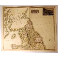
Northern Part of England.
Handsome hand colored map of Northern England, extending as far south as Anglesey. Inset view of ‘The Rope Bridge between the Islands of Holyhead and Anglesey’ at top...
Date: Edinbugh. 1817
Selling price: ????
Please login to see price!
Sold in 2017
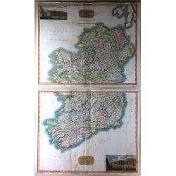
Northern Part of Ireland & Southern Part of Ireland (2 Parts)
This is a striking set of maps of Ireland. Published by John Thomson in Edinburgh in 1817. Essentially two separate maps, the first map (image top) depicts Northern Irela...
Date: Edinburgh, 1817
Selling price: ????
Please login to see price!
Sold in 2016

Set of 8 views from 'Source of the Thames'
Lovely set of seven highly attractive engraved views and the titlepage, by Cooke from his "Source of the Thames". The very decorative views, include much detail...
Date: London, 1819
Selling price: ????
Please login to see price!
Sold in 2011
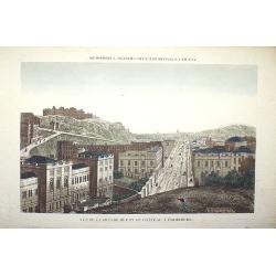
Vue de la grande rue et du château à Edimbourg
Optical print of the Caste of Edinburgh. Basset was a well-known publisher of optical prints, established in rue St Jacques in Paris. In the 18th century the optical prin...
Date: Paris, c.1820
Selling price: ????
Please login to see price!
Sold in 2008
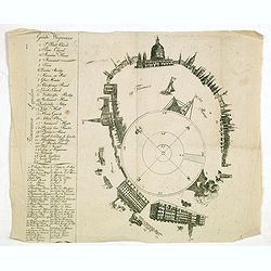
Panorama London.
A separately published key sheet for Robert and Henry Aston Barker’s ‘Panorama of London painted as if viewed from the roof of Albion Mills on the South Bank,’ and ...
Date: London ?, ca. 1820
Selling price: ????
Please login to see price!
Sold in 2017
Stirlingshire.
A fine map of Stirlingshire, Scotland by Thomson in 1820. From his Atlas of Scotland published in Edinburgh. It features an inset of the town of Stirling and an engravin...
Date: Edinburgh, 1820
Selling price: ????
Please login to see price!
Sold in 2023
Index Map to the Atlas of Scotland.
An informative index for Thomson’s “Atlas of Scotland”. Published in 1820 in Edinburgh. It outlines all of the shires in Scotland and states the square miles. It f...
Date: Edinburgh, 1820
Selling price: ????
Please login to see price!
Sold in 2020
Ancient and Modern Ireland.
A lovely large scale map of the island of Ireland, produced in James Playfair's atlas. The various counties are highlighted in differing colors, with major roads marked, ...
Date: Edinburgh, 1821
Selling price: ????
Please login to see price!
Sold in 2022
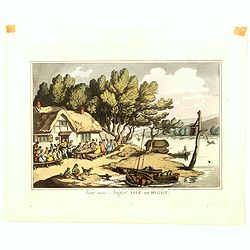
View near Newport Isle of Wight
View near Newport on the Isle of Wight, from an extremely rare series of eighteen aquatint plates, "Rowlandson's Sketches From Nature, depicting views of the West of...
Date: London, 1822
Selling price: ????
Please login to see price!
Sold in 2016
Les Isles Britanniques ou sont le Rme. D'Angleterre . . . Par G. De L'Isle. . . A Paris Chez Dezauche. . .
Uncommon map of the British Isles. The bottom right shows the coasts of the Netherlands, Belgium, and northern France and at the upper right is the southern tip of Norway...
Date: Paris, c.1823
Selling price: ????
Please login to see price!
Sold in 2009
Les Isles Britanniques ou Sont le Rme d\"Angleterre Tire de Speci Celuy d\'Ecosse tire de the Pont &C et Celuy d\'Irlande tire de Petti le tout Rectife par Diverfes Observations.
Map of the British Isles by Guillaume De L'Isle. This wonderfully detailed map includes Great Britain, Scotland, Wales and Ireland, as well as the coast of France. All ma...
Date: Paris, 1823
Selling price: ????
Please login to see price!
Sold in 2010
Le isole Britanniche. . .
Charming map of England, Ireland, Scotland from the rare atlas Atlante Tascabile o sia Serie di Num. XXI Cartine Geografiche nelle quali si rappresenta in ristretto lo St...
Date: Rome, 1823
Selling price: ????
Please login to see price!
Sold in 2011
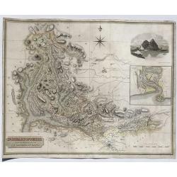
Dumbartonshire Sur'd by Wood for the Atlas of Scotland.
FA fne map of Dumbatonshire, Scotland by John Thomson in 1823. From his Atlas of Scotland published in Edinburgh. It features an inset of the Firth of Clyde and an engrav...
Date: Edinburgh, 1823
Selling price: ????
Please login to see price!
Sold in 2020
Liverpool and its Environs.
An uncommon plan of Liverpool with excellent detail of the city, docks and surrounding countryside. An extensive key identifies important sites and a small vignette shows...
Date: Liverpool, ca 1824
Selling price: ????
Please login to see price!
Sold in 2018
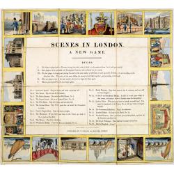
Scenes in London A new game.
A curious game with 18 London scenes. The original slipcase has a hand-colored pictorial label showing the London Thames and in the background St. paul Cathedral, publish...
Date: London, E.Wallis, ca. 1825
Selling price: ????
Please login to see price!
Sold in 2017
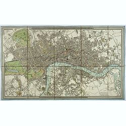
A new Plan of London and Westminster, with the borough of Southwark. 1825.
Beautiful plan of London, Westminster and Southwark, with parks and gardens in green published by James Wyld. To the right of the plan are the famous London docks built i...
Date: London, 1825
Selling price: ????
Please login to see price!
Sold in 2017
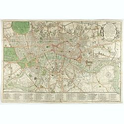
Bowles's one-sheet pan of the cities of London and Westminster
Bowles detailed map of London was updated regularly through the first decade of the 19th century. In addition to providing large scale detail, Bowles maps are also illust...
Date: London, 1825
Selling price: ????
Please login to see price!
Sold in 2022
![Honsdon House & Stanstedbury [2 Litho's].](/uploads/cache/81218-250x250.jpg)
Honsdon House & Stanstedbury [2 Litho's].
Two antique lithographed prints drawn from the original engravings on stone by C.L.Tyler. Published in the second edition of Sir Henry Chauncy's "Historical Antiquit...
Date: Bishop's Stortford, 1826
Selling price: ????
Please login to see price!
Sold in 2020
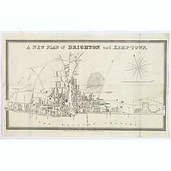
A new plan of Brighton and Kemp-Town.
An attractive and scarce town plan of Brighton and Kemp Town towards the end of the reign of George IV in 1828. You see development all along Kings Road and Marine Parade...
Date: London, 1828
Selling price: ????
Please login to see price!
Sold in 2020
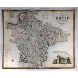
Map of the County of Devon, from an Actual Survey, Made in the Years 1825 & 1826
A very large map of the County of Devon by Christopher Greenwood, published by Greenwood & Co. It has an inset views of Exeter Cathedral and Lundy Island. The brother...
Date: London, 1829
Selling price: ????
Please login to see price!
Sold in 2016
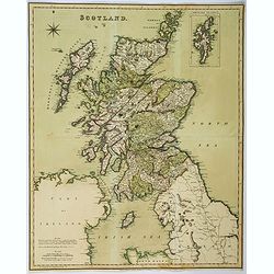
Scotland.
Large folding map of Scotland, published by Henry Teesdale in London. In full body color. Map is detailed with many cities, towns and villages, lochs, main roads, and mou...
Date: London, ca 1829
Selling price: ????
Please login to see price!
Sold in 2018
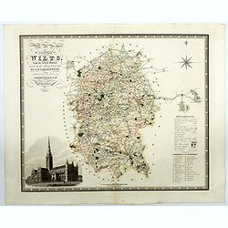
Map of the County of Wilts from an actual survey in the years 1919 & 1820. . .
A superb large scale map of the county of Wiltshire published by the Greenwood brothers. The brothers were surveyors and publishers and undertook the survey of most of th...
Date: London, 1829
Selling price: ????
Please login to see price!
Sold in 2021
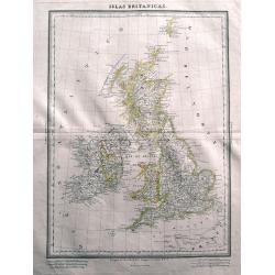
Islas Britanicas.
Very rare Spanish map of the British Isles by Domingo Estrue. With the longitudes east of Madrid. Very detailed map with towns, areas, roads, and many islands shown. Thi...
Date: Madrid, 1830
Selling price: ????
Please login to see price!
Sold in 2014

Winchelsea, Sussex.
Hand-colored steel engraving by J. Henshell after J.M.W. Turner featuring a scene of Winchelsea, Sussex.
Date: London, 1830
Selling price: ????
Please login to see price!
Sold in 2016
Three S.D.U.K. Maps - England I, England III & England IV
Three detailed maps of England by S.D.U.K. published in London in 1830 by Chapman & Hall and engraved by John Walker. “England I” covers Northumberland, Cumberla...
Date: London, 1830
Selling price: ????
Please login to see price!
Sold in 2016
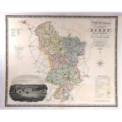
Map of the County of Derby, from an Actual Survey made in the Years 1824 & 1825. By C. & I. Greenwood.
A large map with decorative title at upper right, and a large vignette view of Chatsworth House at lower left. Published by Greenwood & Co. in London in 1830. Engrav...
Date: London, 1830
Selling price: ????
Please login to see price!
Sold in 2016
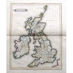
British Islands
Daniel Lizars fine map of the British Isles, pubslished by his son William Hole Lizars. With main roads, counties, cities, etc.
Date: Edinburgh, ca. 1830
Selling price: ????
Please login to see price!
Sold in 2019
![England [sheet IV].](/uploads/cache/44907-250x250.jpg)
England [sheet IV].
A single sheet (4) from a larger set of maps comprising England & Wales, produced for the Society for the Diffusion of Useful Knowledge (S.D.U.K.) in London in 1830. ...
Date: London, 1830
Selling price: ????
Please login to see price!
Sold in 2020
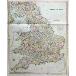
England & Wales
Large and highly detailed map of England & Wales, from Edinburgh to the French coast. Includes ferries to Ireland and Isle of Man, streets with distances between town...
Date: London, 1831
Selling price: ????
Please login to see price!
Sold in 2016
Scotland.
A distinctive woodblock engraved map of Scotland where the printing is reversed - white on black. The map was published in London in 1832 in William Pinnock's "The ...
Date: London, 1832
Selling price: ????
Please login to see price!
Sold in 2012
Ireland.
A distinctive woodblock engraved map of Ireland where the printing is reversed - white on black. The map was published in London in 1832 in William Pinnock's "The Gu...
Date: London, 1832
Selling price: ????
Please login to see price!
Sold in 2012
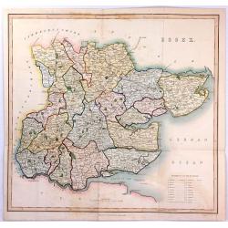
ESSEX
A large steel engraved map labelled "Essex", engraved by James Bingley, published in Virtue's “Picturesque Beauties of Great Britain” in London in 1834.
Date: London, 1834
Selling price: ????
Please login to see price!
Sold in 2016
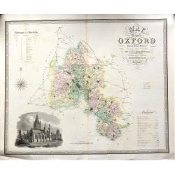
Map of the County of OXFORD from an Actual Survey' by C. & J. Greenwood.
A very attractive and detailed 19th century map of Oxfordshire, replete with a fine vignette view of Oxford Cathedral, which was published in Christopher and John Greenwo...
Date: London, 1834
Selling price: ????
Please login to see price!
Sold in 2018
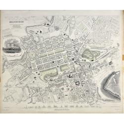
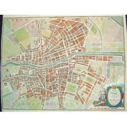
Edinburgh.
A beautiful plan of the city of Edinburgh, Scotland by the Society for the Diffusion of Useful Knowledge. Centred on the Old Town, it covers the city of Edinburgh in exce...
Date: London, 1834
Selling price: ????
Please login to see price!
Sold in 2020
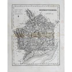
(Lot of 2 maps) Wales - Monmouthsthire
An interesting pair of old maps of Wales: - Fullarton, ca. 1835, "Monmouthshire". 240 x 190 mm. A detailed map with much information, showing also the distance...
Date: England, c1835
Selling price: ????
Please login to see price!
Sold in 2012
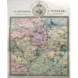
A new & improved map of the environs of Windsor, extending from 14 to 18 miles round the castle.
An apparently very scarce map (Copac with only 2 listings) of the area around Windsor. The map includes roads and distances. The title with a decorative vignette. Drawn ...
Date: London, ca. 1835
Selling price: ????
Please login to see price!
Sold in 2023
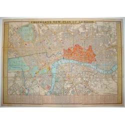
Cruchley's New Plan of London Shewing all the New and Intended Improvements to the Present Time
One of the more desirable and sought after plans of London. Demand for Cruchley London plans has grown substantially in recent years. At a 2006 Bonhams auction, an 1828...
Date: London, 1836
Selling price: ????
Please login to see price!
Sold
Map of the Canals and Navigable Rivers in England, Wales and Scotland. . .
From The History of Lancashire by Edward Baines, engraved by Hall, and by William Swire, Surveyor, Leeds. Shows all of England and Wales and Scotland as far north as Pert...
Date: Leeds, 1824-1836
Selling price: ????
Please login to see price!
Sold in 2021
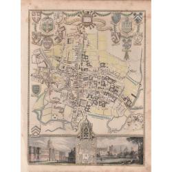
'CITY AND UNIVERSITY OF OXFORD'.
A highly detailed, finely engraved, hand colored plan of the University City of Oxford, embellished with the heraldic shields, arms of the Town, the University, and its c...
Date: London, 1837
Selling price: ????
Please login to see price!
Sold in 2019
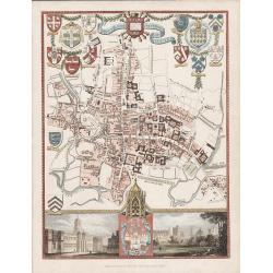
'CITY AND UNIVERSITY OF OXFORD'
A steel engraving by James Bingley in 1837 for Moule's "English Counties Delineated" The 1830 -1837 editions of this map are scarce.An attractive and highly det...
Date: London, 1837
Selling price: ????
Please login to see price!
Sold in 2016
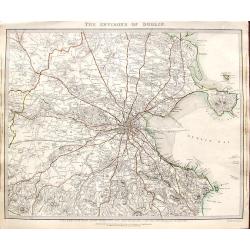
The environs of Dublin.
A very detailed map of the region surrounding Dublin, extending to Killiney Bay, Muldouny Bay and County Kildare. The map also locates churches, lodges, parks, roads, etc...
Date: London, 1837
Selling price: ????
Please login to see price!
Sold in 2018
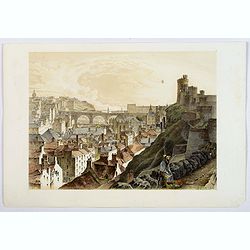
The Trongate, Glasgow. . .
An attractive tinted lithograph from a folio of some 26 tinted litho's, titled Sketches in Scotland, Drawn on Stone from Nature. by Samuel Swarbreck. Signed, dated and ti...
Date: London, 1837
Selling price: ????
Please login to see price!
Sold in 2020
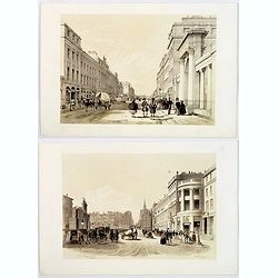
(Two prints) North Bridge Street Edinburgh / The Regents Bridge, Waterloo Place, Edinburgh.
An attractive pair of tinted lithograph of Edinburgh street scenes from a folio of some 26 tinted litho's, titled Sketches in Scotland, Drawn on Stone from Nature. by Lon...
Date: London, 1837
Selling price: ????
Please login to see price!
Sold in 2019
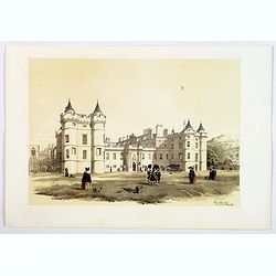
Holyrood Palace & Chapel with Arthur's Seat and Salisbury Crags.
A fine Edinburgh lithograph entitled “Holyrood Palace And Chapel With Arthur’s Seat And Salisbury Crags ” by the London-born artist Samuel Swarbreck. It dates from ...
Date: London, 1837
Selling price: ????
Please login to see price!
Sold in 2018
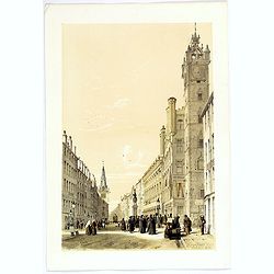
The North Bridge & part of the New & Old Towns of Edinburgh.
A fine Edinburgh lithograph showing the historic North Bridge, linking the New and Old Towns of Edinburgh, by the London-born artist Samuel Swarbreck. It dates from 1837 ...
Date: London, 1837
Selling price: ????
Please login to see price!
Sold in 2018
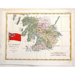
La Scozia Meridionale.
Striking Marmocco map with his signature map (Southern Scotland) added. Francesco Costantino Marmocchi (1805 - 1858 ) was an Italian geographer . His other writings de...
Date: Florence, 1838
Selling price: ????
Please login to see price!
Sold in 2014
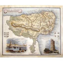
Isle of Thanet.
Decorative map oF the Island of Thanet, Kent with two views and 2 coats of arms. This is a map from "ENGLISH COUNTIES DELINEATED" by Thomas Moule who combined a...
Date: London, 1838
Selling price: ????
Please login to see price!
Sold in 2014
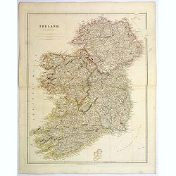
Ireland.
An attractive steel engraved map of Ireland, with each county divided by a different color. A pleasing amount of detail is provided. Also with a small inset map naming th...
Date: London, 1839
Selling price: ????
Please login to see price!
Sold in 2023
La Gran Brettagna . . . .
A rare and detailed double-page map of Great Britain with three inset maps upper left of the Shetland Mainland Islands, the Helgoland Island (occupied by the English in 1...
Date: Venice, 1840
Selling price: ????
Please login to see price!
Sold in 2011
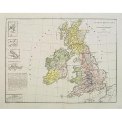
Iles Britanniques.
Finely engraved map of British Isles prepared by A.H.Dufour and engraved by Giraldon-Bovinet. Published by Jules Renouard in his uncommon atlas "Le globe Atlas class...
Date: Paris, Jules Renouard, ca.1840
Selling price: ????
Please login to see price!
Sold in 2011
Somersetshire.
Nice hand-colored map of Somersetshire with a fine engraving cartouche of Glastonbury Cross. It also has two coats of arms. Thomas Moule (1784 - January 1851) was an Eng...
Date: London, 1840
Selling price: ????
Please login to see price!
Sold in 2013
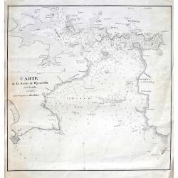
Carte de la rade de Plymouth avec le Môles excuté par l. ingénieur John Renie.
Rare sea-chart of the Plymouth Sound, engraved by Edler. With numerous depth soundings, shoals, buoys, and important landmarks including relevant buildings such as: Tarpo...
Date: unknown, c1840
Selling price: ????
Please login to see price!
Sold in 2018
Cumberland.
Highly detailed map of the county, with a nice view of Carlisle shown from the North East. The map shows towns and villages, streets, lakes, rivers, forests, hills, etc. ...
Date: Glasgow, c1840
Selling price: ????
Please login to see price!
Sold in 2016
England & Wales.
Highly detailed map of England & Wales. The map provides good topographic details. The title is inside a frame-style cartouche. By F.W. Topham in London in 1840.
Date: London, 1840
Selling price: ????
Please login to see price!
Sold in 2021
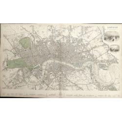
London.
A detailed plan of London, from Kensington to the East India Docks and Battersea to Holloway. Decorated with two vignettes of the Tower of London and a view of St.Paul's....
Date: London, 1843
Selling price: ????
Please login to see price!
Sold in 2012
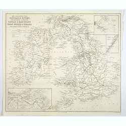
Map Exhibiting the Navigable Rivers, the completed & proposed Canals, & Rail-Roads of Great Britain & Ireland. . .
A large folded map of the navigable rivers, plus the existing or proposed canals and railways of G.B. & Ireland, originally published in London, but this example is p...
Date: New York, 1843
Selling price: ????
Please login to see price!
Sold in 2019
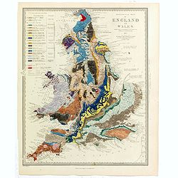
Geological Map of England and Wales . . .
Fascinating geological map of England and Wales.
Date: London, 1843
Selling price: ????
Please login to see price!
Sold in 2020
