Browse Listings in Europe
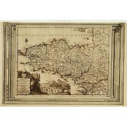
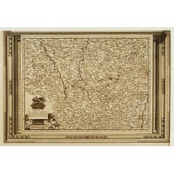
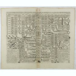
Carte du gouvernement de Bretagne, suivant les nouvelles observations..
Uncommon edition of this map of a province of France. With decorative title cartouche lower left corner.This example is unusual in having the additional separately engrav...
Date: Amsterdam 1728
Selling price: ????
Please login to see price!
Sold
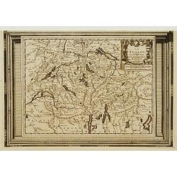
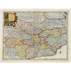
Le Piemont, suivant les nouvelles observations..
Uncommon edition of this map of a province of Italy. With decorative title cartouche upper left corner.This example is unusual in having the additional separately engrave...
Date: Amsterdam 1728
Selling price: ????
Please login to see price!
Sold
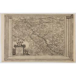
L'Archeveché de Cologne, suivant les nouvelles observations..
With decorative title cartouche lower left corner.This example is unusual in having the additional separately engraved decorative framework border around the map, the res...
Date: Amsterdam 1728
Selling price: ????
Please login to see price!
Sold in 2023
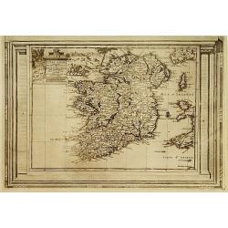
L'Irlande, suivant les nouvelles observations..
Fine map of Ire land, with decorative title cartouche lower left corner.This example is unusual in having the additional separately engraved decorative framework border a...
Date: Amsterdam, 1728
Selling price: ????
Please login to see price!
Sold in 2015
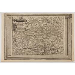
Carte de Loraine, suivant les nouvelles observations..
With decorative title cartouche lower left corner.This example is unusual in having the additional separately engraved decorative framework border around the map, the res...
Date: Amsterdam 1728
Selling price: ????
Please login to see price!
Sold
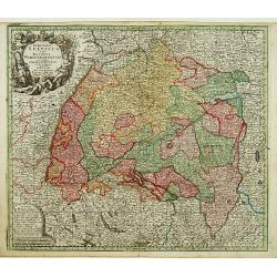
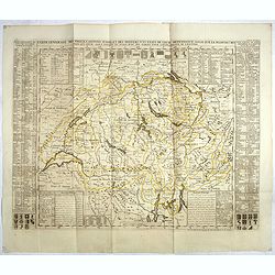
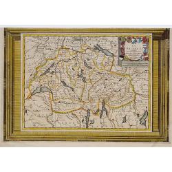
La Suisse, suivant les nouvelles observations..
Detailed map of Switzerland, with decorative title cartouche upper right corner.This example is unusual in having the additional separately engraved decorative framework ...
Date: Amsterdam 1728
Selling price: ????
Please login to see price!
Sold in 2017
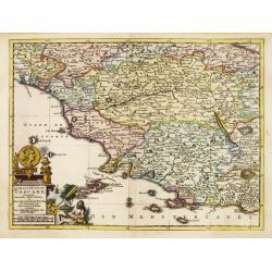
Le grand duché de Toscane, suivant les nouvelles observations..
Uncommon map of Tuscany. With decorative title cartouche lower left corner.This example is unusual in having the additional separately engraved decorative framework borde...
Date: Amsterdam 1728
Selling price: ????
Please login to see price!
Sold
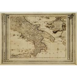
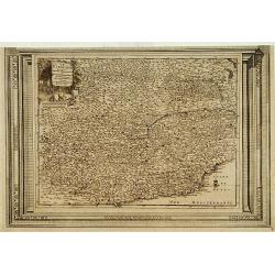
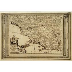
Le Royaume de Naples, suivant les nouvelles observations..
Uncommon map of southern part of Italy and northern coastline of Sicily, including Palermo. With decorative title cartouche upper right corner.This example is unusual in ...
Date: Leiden, 1728
Selling price: ????
Please login to see price!
Sold in 2018
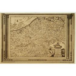
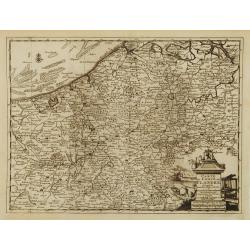
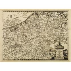
Carte du Comté de Flandre, suivant les nouvelles observations..
Including Belgium and Brabant. With decorative title cartouche lower right corner.This example is unusual in having the additional separately engraved decorative framewor...
Date: Amsterdam 1728
Selling price: ????
Please login to see price!
Sold
Cercle du Haut Rhin, suivant les nouvelles observations..
With decorative title cartouche upper left corner.This example is unusual in having the additional separately engraved decorative framework border around the map, the res...
Date: Amsterdam, 1728
Selling price: ????
Please login to see price!
Sold in 2023
Circulus Suevicus in quo Ducatus Wirtenbergensis...
Map of Swabia including Strasburg, Manheim, Lucern, Boden See, Stuttgart...
Date: Augsbourg, 1728
Selling price: ????
Please login to see price!
Sold
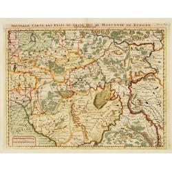
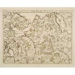
Nouvelle Carte des Etats..Moscovie en Europe.
Detailed map of central Russia. Moscow in the centre of the map. From Chatelain's Atlas Historique et Méthodique .
Date: Amsterdam 1728
Selling price: ????
Please login to see price!
Sold
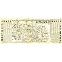
Nouvelle carte des etats du grand duc de Moscovie en Europe.
Northern part of European Russia.
Date: Amsterdam 1728
Selling price: ????
Please login to see price!
Sold
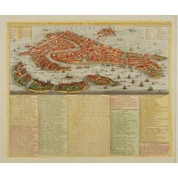
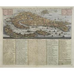
Carte du plan de Venise..
Extremely detailed bird's-eye view of Venice with scores of ships and gondolas shown throughout. The text panels list monasteries, churches, palaces, bridges, and the nam...
Date: Amsterdam 1728
Selling price: ????
Please login to see price!
Sold
Carte du Comté de Flandre, suivant les nouvelles observations..
Including Belgium and Brabant. With decorative title cartouche lower right corner.
Date: Amsterdam 1728
Selling price: ????
Please login to see price!
Sold
Le Piemont, suivant les nouvelles observations..
Uncommon edition of this map of a province of Italy. With decorative title cartouche upper left corner.
Date: Amsterdam 1728
Selling price: ????
Please login to see price!
Sold
Le grand duché de Toscane, suivant les nouvelles observations..
Uncommon map of Tuscany. With decorative title cartouche lower left corner.
Date: Amsterdam 1728
Selling price: ????
Please login to see price!
Sold
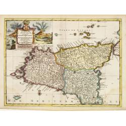
L'Isle de Sicile. Suivant les nouvelles observations?
Detailed map of Sicily. Decorative cartouche lower left.Although not renowned for the originality of his work, Pieter van der Aa is highly thought of for the design and q...
Date: Amsterdam 1728
Selling price: ????
Please login to see price!
Sold
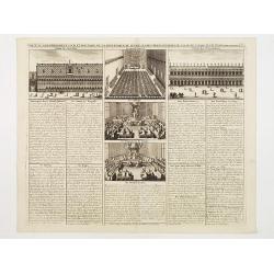
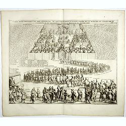
Carte du Gouvernement Civil et Politique de la Republique de Venise..
This impressive engraving is a wonderful example of Chatelain?s elegant plates. It provides a detailed description of the infrastructure of the Venetian government. Ornam...
Date: Amsterdam 1728
Selling price: ????
Please login to see price!
Sold
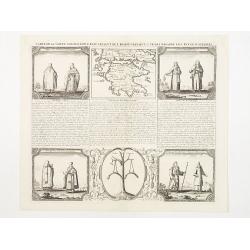
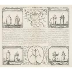
Carte de la Grece contenant l'Etat present de l'Eglise Grecque &..
Handsome chart with a small map of Greece (115 x 150) together with five Greek religious scenes and descriptive French text.
Date: Amsterdam 1728
Selling price: ????
Please login to see price!
Sold in 2009
Carte du Comté de Flandre, suivant les nouvelles observations..
Including Flanders and part of Brabant. With decorative title cartouche lower right corner with coat of arms, a farmer and a person weaving textiles.
Date: Amsterdam 1728
Selling price: ????
Please login to see price!
Sold
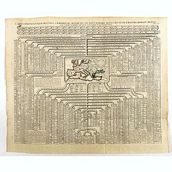
Carte chronologique des etats et empires du monde, qui se sont former de la chute de l'empire romain, depuis le commencement de . . .? vulgaire, jusqu'a present. . .
Extremely interesting sheet with a small map of Europe at center and chronological tables in French tracing the ancestry of the royal houses of Europe. From: Atlas Histor...
Date: Amsterdam, 1728
Selling price: ????
Please login to see price!
Sold in 2008
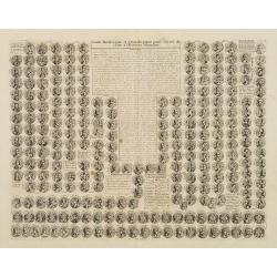
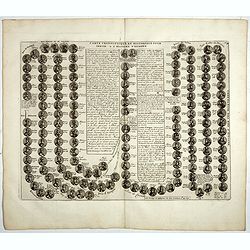
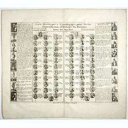
Carte historique et chronologique pour servir de suite a l histoire Romaine. . .
Extremely interesting sheet with a small portraits of the Roman Emperors.From: Atlas Historique.
Date: Amsterdam, 1728
Selling price: ????
Please login to see price!
Sold in 2008
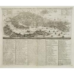
Carte du plan de Venise, l'état de sa noblesse, et ses differens degrez a ec quelques autres remarques curieuses sur cette superbe ville. Tome 2 N° 4.
Extremely detailed bird's-eye view of Venice with scores of ships and gondolas shown throughout. The text panels list monasteries, churches, palaces, bridges, and the nam...
Date: Amsterdam, 1728
Selling price: ????
Please login to see price!
Sold in 2008
Carte du plan de Venise, l'état de sa noblesse, et ses differens degrez a ec quelques autres remarques curieuses sur cette superbe ville. Tome 2 N° 74.
Extremely detailed bird's-eye view of Venice with scores of ships and gondolas shown throughout. The text panels list monasteries, churches, palaces, bridges, and the nam...
Date: Amsterdam, 1728
Selling price: ????
Please login to see price!
Sold
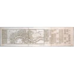
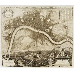
Londen.
Rare map of London with a legend in margins from: Force d'Europe, oder die Merckwürdigst– und Fürnehmste, meistentheils auch Ihrer Fortification wegen Berühmteste St...
Date: Augsburg, 1728
Selling price: ????
Please login to see price!
Sold in 2015
Carte de la Grece contenant l'Etat present de l'Eglise Grecque &..
Handsome chart with a small map of Greece (115 x 150mm.) together with five Greek religious scenes and descriptive French text.
Date: Amsterdam, 1728
Selling price: ????
Please login to see price!
Sold in 2010
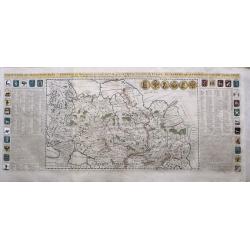
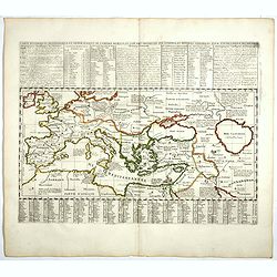
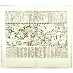
Carte générale des états du Czar Empereur de Moscovie, ou l'on voit ce que ce prince posséde en Europe et les états qu'il posséde en Asie.
General map of Russia of the states of the Czar Emperor of Muscovy showing his possessions in Europe and Asia. To the left and right explanatory panels with coats of arms...
Date: Amsterdam, 1728
Selling price: ????
Please login to see price!
Sold in 2011
Carte du Gouvernement Civil et Ecclesiastique de Moscovie, l'Etat des Revenus et l'Ordre de la Justice et des Officiers
Very fine engraved text sheet with a small (5.5 x 5.5"), detailed plan of Moscow, plus two large coats-of-arms. Descriptive French text below, size is for the overal...
Date: Amsterdam, ca. 1728
Selling price: ????
Please login to see price!
Sold in 2010
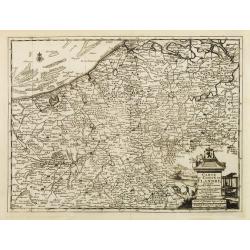
Carte du Comté de Flandre, suivant les nouvelles observations. . .
Including Flanders and part of Brabant. With decorative title cartouche lower right corner with coat of arms, a farmer and a person weaving textiles.
Date: Amsterdam, 1728
Selling price: ????
Please login to see price!
Sold in 2022
Nieuwe en Nette Aftekening van het Eyland of Koningkrijk Sardinia..
Fine, large map of Sardinia made by Gerard van Keulen.
Date: Amsterdam, 1728
Selling price: ????
Please login to see price!
Sold in 2013
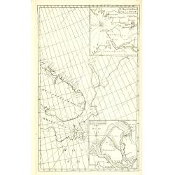
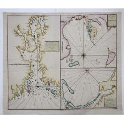
A Chart of the Sound -- A Map of the rivers Elbe and Weser -- The River Dvina and the harbour of Archangel.
Scarce sea chart by John Harris (1667?-1719) and James Knapton (d. 1738). Chart 20 from "Atlas maritimus & commercialis", showing Lapland and part of the Ru...
Date: London, J. Knapton, 1728
Selling price: ????
Please login to see price!
Sold in 2013
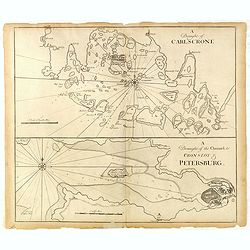
A Draught of Carlscone. A Draught of the Channel to Cronslot & Petersburg.
Two charts on one sheet: the upper chart is Karlskrona in Sweden, built as a base for the Royal Swedish Navy.The lower chart shows the approaches to St Petersburg, with K...
Date: London: J. & J. Knapton, W. & J. Innys, 1728
Selling price: ????
Please login to see price!
Sold in 2015
Carte Generale des Etats du Czar Empereur De Moscovie
A large and dramatic depiction of the Czars and their vast territories from 15th century to the early 18th century. Twenty-eight armorial shields, all color coded, are se...
Date: Amsterdam, ca 1728
Selling price: ????
Please login to see price!
Sold in 2015
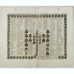
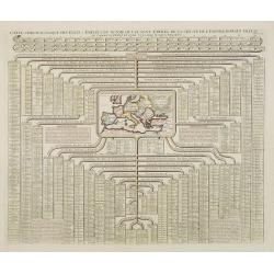
Carte genealogique des Rois de France avec l'Etat des Principaux Officiers de la Maison du roy.
A genealogical tree of the French kings with descriptive French text, from Chatelain's monumental 7 volume "Atlas Historique". Henri Abraham Chatelain (1684 –...
Date: Amsterdam, 1728
Selling price: ????
Please login to see price!
Sold in 2016
Carte Historique & Cronologique pour Servir d'Introduction a l'Histoire des Provinces Unies des Pays-Bas.
This folio sheet shows a genealogical chart and portraits of the rulers of Holland and Flanders with descriptive French text, from Chatelain's monumental 7 volume "A...
Date: Amsterdam, 1728
Selling price: ????
Please login to see price!
Sold in 2016
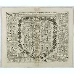
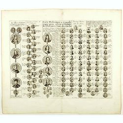
Carte Genealogique Des Maisons Imperialles Depuis Charles-Magne...
Fascinating genealogical tree, showing the lineage of Charlemagne through the modern era, including the ruling families of Astria, Spain, Suabe, Germany, Saxony, and Luxe...
Date: Amsterdam, 1728
Selling price: ????
Please login to see price!
Sold in 2016
Carte genealogique pour conduire à faire connoître sur quoi sont fondés les pre tendants à la succession de la principauté de Neufchatel.
Genealogical tree with two maps "Principauté de Neuchatel" and "Baronie de Arley de la Maison de Chalons", with descriptive French text, from Chatela...
Date: Amsterdam, 1728
Selling price: ????
Please login to see price!
Sold in 2020
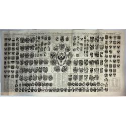
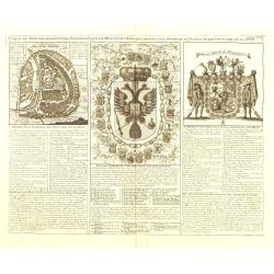
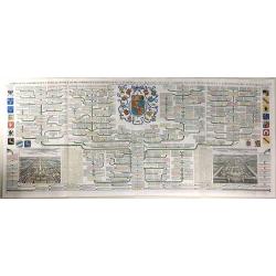
Carte Heraldique Representant Les Armes De L' Empereur Des Electeurs Des Princes Tant Ecclesiastiques Que Seculiers Et De Tous Les Etats Du Saint Empire Romain
A magnificent large copper engraved chart, illustrating the coats of arms of the Emperor, Electors and Princes of the Holy Roman Empire. At its centre is the fantastic ar...
Date: Amsterdam, 1728
Selling price: ????
Please login to see price!
Sold in 2018
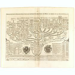
Genealogie de la maison de Holstein, ses diferentes branches, ses titres, ses armes et ses aliances.
This handsome genealogical chart is a wonderful example of Chatelain’s elegant engravings. Included in the Atlas Historique, published by Chatelain in Amsterdam, this l...
Date: Amsterdam, 1728
Selling price: ????
Please login to see price!
Sold in 2016
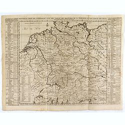
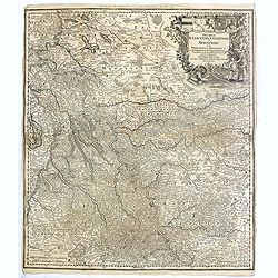
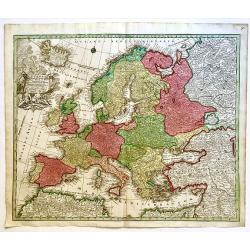
Nouvelle Carte de l'Alemagne avec des tables des branches de la noblesse...
Map of Germany including parts of the neighbouring countries with a key table to the towns on both sides.Zacharie Chatelain (d.1723) was the father of Henri Abraham (1684...
Date: Amsterdam, ca. 1728
Selling price: ????
Please login to see price!
Sold in 2021
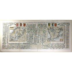
Carte Généalogique Pour Conduire à l'Histoire des Rois du Nord de la Carte de Leurs Etats, Leurs Armes et des Remarques Pour Conduire à l'Intelligence de l'Histoire du Nord
A very detailed, and wonderfully colored, composite sheet, with a genealogical table of the Kingdoms of the Scandinavian countries, with two small maps: Scandinavia and S...
Date: Amsterdam, 1728
Selling price: ????
Please login to see price!
Sold in 2016
Carte Genealogique de la Famille Royale de Brunswick, Lunebourg, Hanover & les Differentes Branches.
A very detailed, and beautifully colored, composite sheet with a genealogical table of the German royal families of Brunswick, Lunebourg and Hanover, with descriptive Fre...
Date: Paris, 1728
Selling price: ????
Please login to see price!
Sold in 2016
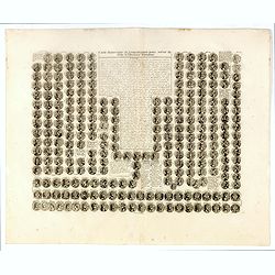
Carte historique et chronologique pour servir de suite a l histoire Romaine. . .
Extremely interesting sheet with a small portraits of the Roman Emperors.From: Atlas Historique.More about Chatelain Atlas. [+]
Date: Amsterdam, 1728
Selling price: ????
Please login to see price!
Sold in 2016
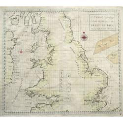
A Chart Describing part of the coast of Great-Britain, from the South Foreland to Berwick.
Very rare sea-chart of the coasts of England and Wales, including the Isle of Man, and the east coast of Ireland. With numerous place names and depth soundings. With two ...
Date: London, 1728
Selling price: ????
Please login to see price!
Sold in 2016
Nova et Accurata Ducatus Cliviae et Comitatus Marchiae.
Seutter's map of the German Duchies Jülich, Cleves, Berg with the County of Mark. With an elaborate -uncolored- title cartouche in upper right corner.
Date: Augsburg, 1728
Selling price: ????
Please login to see price!
Sold in 2016
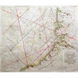
Nouvelle Cartemarine croissante...Normandie, Vimeux, et Ponthieu, entirant depuis Etaples...
A detailed copper-engraved sea chart of a part of Normandy, from Dieppe until Etaples.Locates a number of towns along the coast, including Montreuil, Berck, Rue, Saint-Va...
Date: Amsterdam, 1728
Selling price: ????
Please login to see price!
Sold in 2016
Carte chronologique des etats et empires du monde, qui se sont former de la chute de l'empire romain, depuis le commencement de . . .? Vulgaire, jusqu'a present. . .
Extremely interesting sheet with a small map of the Roman Empire at center. Published by Henri Abraham Chatelain (1684 – 1743) who was a Huguenot pastor of Parisian ori...
Date: Amsterdam, 1728
Selling price: ????
Please login to see price!
Sold in 2020
Carte du Gouvernement Civil et Politique de l'Espagne . . .
This impressive engraving provides a detailed description of the infrastructure of the Spanish government. Ornamented with numerous vignettes illustrating sessions of par...
Date: Amsterdam, 1728
Selling price: ????
Please login to see price!
Sold in 2021
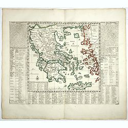
Carte historique et géographique de l'ancienne Grece . . .
A map of Greece during the Roman Empire, with descriptive French text, from Chatelain's monumental 7 volume Atlas Historique. In upper right margin: 'N°6.Henri Abraham C...
Date: Amsterdam, 1728
Selling price: ????
Please login to see price!
Sold in 2022
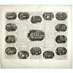
Carte pour donner une idée generale du gouvernement D'Ecosse . . .
Illustrating the activities and principal members of the Scottish Parliament. Remarkable detail, with over 30 individuals and groups named.Henri Abraham Chatelain (1684 �...
Date: Amsterdam, 1728
Selling price: ????
Please login to see price!
Sold in 2019
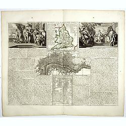
Nouvelle carte du gouvernement civil D'Angleterre et de celuy de la ville de Londres.
Striking plan of London, with map of England and two large allegorical figures of Liberty, Justice, Tranquility Rest and Patriotism to the left vignette and Commerce and ...
Date: Amsterdam, 1728
Selling price: ????
Please login to see price!
Sold in 2018
Carte generale des treize cantons Suisse et des differents etats de leur dependence . . .
Striking large format map of Switzerland, divided by Cantons and other dependent regions. Includes 13 large coats of arms and 22 smaller coats of arms for the various maj...
Date: Amsterdam, 1728
Selling price: ????
Please login to see price!
Sold in 2017
DRAM and CHRISTIANIA / HARBOUR of REVEL / DANTZICK and KONINGSBERG
A scarce sea chart with three inset maps of Oslo (Christiania); Danzig and Kaliningrad (Konigsberg); and Tallin, Estonia.This very rare work was a collaborative effort of...
Date: London, 1728
Selling price: ????
Please login to see price!
Sold in 2017
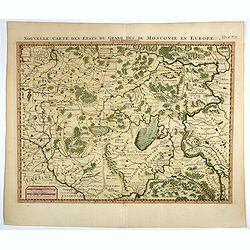
Nouvelle carte des etats du grand duc de Moscovie en Europe.
Northern part of European Russia, Lithuania, Poland and the Ukraine with many references to Cossacks.Zacharie Chatelain (d.1723) was the father of Henri Abraham (1684-174...
Date: Amsterdam, 1728
Selling price: ????
Please login to see price!
Sold in 2017
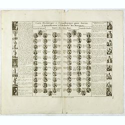
Carte cronologique et Historique pour servir a l'histoire d'Espagne.
This impressive engraving is a wonderful example of Chatelain’s elegant plates showing a genealogical chart and portraits of the kings of Spain and Portugal, from 406AD...
Date: Amsterdam, 1728
Selling price: ????
Please login to see price!
Sold in 2018
Carte Historique & Cronologique pour Servir d'Introduction a l'Histoire des Provinces Unies des Païs-Bas.
This folio sheet shows a genealogical chart and portraits of the rulers of Holland and Flanders with descriptive French text, from Chatelain's monumental 7 volume "A...
Date: Amsterdam, 1728
Selling price: ????
Please login to see price!
Sold in 2018
Carte historique cronologique de l'empire Romain ou l'on fait observer son etendue et diverses remarques pour l'intelligence de l'histoire . . .
In the center a map (207 x 446mm.) of the extent of the Roman Empire (Europe and the Middle East). Above and below extensive explanatory notes. Shown is the track of Juli...
Date: Amsterdam, 1728
Selling price: ????
Please login to see price!
Sold in 2018
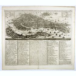
Carte du plan de Venise, l'état de sa noblesse, et ses differens degrez a ec quelques autres remarques curieuses sur cette superbe ville. Tome 2 N° 4.
Extremely detailed bird's-eye view of Venice with scores of ships and gondolas shown throughout. The text panels list monasteries, churches, palaces, bridges, and the nam...
Date: Amsterdam, 1728
Selling price: ????
Please login to see price!
Sold in 2018
Generalis Totius Imperii Moscovitici Novissima Tabula. . .
A large map showing the whole of Russia; from the Black Sea and the Baltic to Kamchatka, China, and Northern India. Beautifully engraved and highly detailed, the map show...
Date: Neurenberg, 1728
Selling price: ????
Please login to see price!
Sold in 2018
Carte historique chronologique et géographique de l'empire Grec . . .
Interesting sheet with a map of the Roman Empire, with descriptive French text, from Chatelain's monumental 7 volume Atlas Historique.Henri Abraham Chatelain (1684 – 17...
Date: Amsterdam, 1728
Selling price: ????
Please login to see price!
Sold in 2021
Carte Historique & Cronologique pour Servir d'Introduction a l'Histoire des Provinces Unies des Païs-Bas.
This folio sheet shows a genealogical chart and portraits of the rulers of Holland and Flanders with descriptive French text, from Chatelain's monumental 7 volume "A...
Date: Amsterdam, 1728
Selling price: ????
Please login to see price!
Sold in 2019
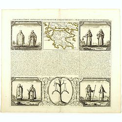
Carte de la Grece contenant l'Etat present de l'Eglise Grecque &. . .
Handsome chart with a small map of Greece (115 x 150mm.) together with five Greek religious scenes and descriptive French text.Zacharie Chatelain (d.1723) was the father ...
Date: Amsterdam, 1728
Selling price: ????
Please login to see price!
Sold in 2020
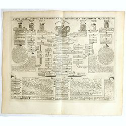
Carte genealogique de la Pologne et les principalles branches ses rois.
Genealogical tree, showing the lineage of the Polish Kings, dating back to 700. Henri Abraham Chatelain (1684 – 1743) was a Huguenot pastor of Parisian origins. He live...
Date: Amsterdam, 1728
Selling price: ????
Please login to see price!
Sold in 2018
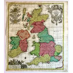
Regnorum Angliae, Scotiae Hiberniae.
A superb 18th century original hand colored map of Seutter's British Isles, with a portrait of George I and the Hanoverian coat-of-arms in the title cartouche. In the sca...
Date: Augsburg, 1728
Selling price: ????
Please login to see price!
Sold in 2019
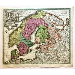
Synopsis Plagae Septentrionalis size Sueciae Daniae et Norwegiae Regn.
A superb 18th century original hand colored map of Scandinavia that extends to the east to include portions of Russia, the Baltic states, and the northern part of Germany...
Date: Vienna, 1728
Selling price: ????
Please login to see price!
Sold in 2019
Europa Religionis Christianae. . .
A superb 18th century original hand colored regional map of Europe with a spectacular cartouche featuring religious and allegorical figures signifying Christianity as a m...
Date: Augsburg, 1728
Selling price: ????
Please login to see price!
Sold in 2019
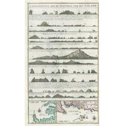
Landkenningen Aen De Zuyd West Syde Van Ysland
A rare cartographic work showing the coastlines of Iceland as they would appear from a ship at sea. The map title and descriptions of the coat are all done in Islandic la...
Date: Amsterdam, 1728
Selling price: ????
Please login to see price!
Sold in 2023

Grande Pologne et Prusse avec les frontières de la Misnie, Lusace, Moravie et Lithuanie.
Detailed map of Poland and Prussia. Published by Pieter van der Aa who published a.o. "Naauwkeurge versameling der gedenkwaardigste zee- en land-reysen", a seri...
Date: Leiden, 1729
La Suisse. Suivant les nouvelles observations..
Decorative map, due to its fine border. The map itself is printed within a decorative border, printed from a different plate.
Date: Amsterdam 1729
Selling price: ????
Please login to see price!
Sold
Londini Angliae regni metropolis delineatio accuratissima ..
A beautifully engraved and richly detailed plan of London. In upper right part a key to 148 principal spots in the town. From Galerie Agréable du Monde, a sixty-six volu...
Date: Leiden 1729
Selling price: ????
Please login to see price!
Sold
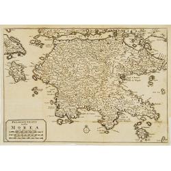
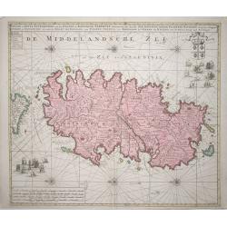
Peloponnesus hodie Morea.
Decorative regional map of Morea and contiguous islands.
Date: Leiden 1729
Selling price: ????
Please login to see price!
Sold
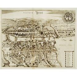
Tigurum Zürüch.
A beautifully engraved and richly detailed plan of Zürich. In upper right part a key to 27 principal spots in the town. Originally engraved for the rare town book of Fre...
Date: Leiden 1729
Selling price: ????
Please login to see price!
Sold

Basilea Basel.
A beautifully engraved and richly detailed plan of Basel. In upper right part a key to 42 principal spots in the town. Originally engraved for the rare town book of Frede...
Date: Leiden 1729
Selling price: ????
Please login to see price!
Sold
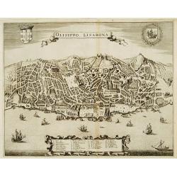
Olisippo. Lisabona.
A beautifully engraved and richly detailed plan of Lisbon. In bottom part a key to 34 principal spots in the town. Originally engraved for the rare town book of Frederick...
Date: Leiden 1729
Selling price: ????
Please login to see price!
Sold
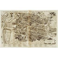
La villa de Madrid corte delos reyes catolicos de Espagne.
A beautifully engraved and richly detailed plan of Madrid. In bottom part a key to 67 principal spots in the town. Originally engraved for the rare town book of Frederick...
Date: Leiden 1729
Selling price: ????
Please login to see price!
Sold
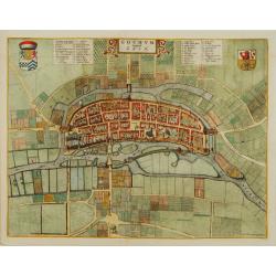
Goghum. Vernavule Goch.
A beautifully engraved and richly detailed plan of Gogh. In upper part a numbered key (1-42). From Galerie Agréable du Monde, a sixty-six volume atlas complied in 1729 a...
Date: Leiden 1729
Selling price: ????
Please login to see price!
Sold
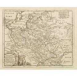
Veteris et Novae Regni Poloniae Magniq Ducatus Lithuaniae Cum Suis Palatinatibus ac Consinus Descriptio.
A simple map displays the region from the Baltic to the Black Sea, centered on Lithuania.It is filled with ancient place names. Presents a decorative title cartouche in t...
Date: Amsterdam, 1729
Selling price: ????
Please login to see price!
Sold in 2008
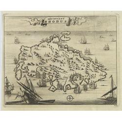
Het Eylant Rhodus.
An attractive bird's eye-view of the island of Rhodes. Pieter van der Aa was a prolific publisher. He published a.o. "Naaukeurige versameling der gedenkwaardigste ze...
Date: Leiden, 1729
Selling price: ????
Please login to see price!
Sold in 2009
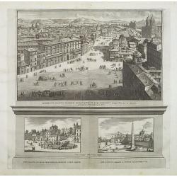
Prospectus Palatii Oratoris Hispaniarum, et fori Hispanici. . .
Three plates on one sheet. Upper one showing Piazza di Spagna in Rome. Pieter van der Aa was a prolific publisher. He published a.o. "Naaukeurige versameling der ged...
Date: Leiden, 1729
Selling price: ????
Please login to see price!
Sold in 2009