Browse Listings in Europe

Carte genealogique de la Maison de Bourbon . . .
Genealogical chart of the Bourbons, from Chatelain's monumental 7 volume "Atlas Historique". Henri Abraham Chatelain (1684 – 1743) was a Huguenot pastor of Pa...
Date: Amsterdam, 1720
Selling price: ????
Please login to see price!
Sold in 2018
Carte genealogique des premiers rois de Naples, de Sicile et de Hongrie . . .
Genealogical chart of kings of Naples, Sicily and Hungary, from Chatelain's monumental 7 volume "Atlas Historique". Henri Abraham Chatelain (1684 – 1743) was ...
Date: Amsterdam, 1720
Selling price: ????
Please login to see price!
Sold in 2018
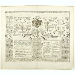
Carte Genealogique de la Maison Imperiale d'Autriche & les Differentes Branches qu'elle a Formees Accompagnee des Trophees des Armes Imperiales & d'Espagne ...
An engraved genealogical family tree of Imperial Austria illustrating its links with the Spanish royal family. Their respective arms dominate the plate with views of the ...
Date: Amsterdam, ca. 1720
Selling price: ????
Please login to see price!
Sold in 2018
Carte genealogique de la maison des Valois. . .
Ornamented with numerous vignettes representing Place Royal, Palais des Tuilleries and Palais du Luxembourg in Paris.Exhaustive information about the settlements is given...
Date: Amsterdam, ca. 1720
Selling price: ????
Please login to see price!
Sold in 2022
Regnum Borussiae gloriosis auspiciis serenissimi et potentissimi princip. Friderici III primi Borussiae regis march. et elect. Brandenburg inauguratum die 18 Jan...1701.
Map covering the region along the Baltic Sea from Prussia to northern Poland.Beautiful ornamental title cartouche in upper middle with later color addition. Centered on D...
Date: Nuremberg, 1720
Selling price: ????
Please login to see price!
Sold
Carte genealogique de la Maison de Savoye . . .
Fine example of Chatelain's attractive plate showing the genealogy of the Savoy House in France.Zacharie Chatelain (d.1723) was the father of Henri Abraham (1684-1743) an...
Date: Amsterdam, ca. 1720
Selling price: ????
Please login to see price!
Sold in 2018
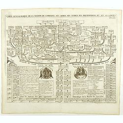
Carte genealogique de la Maison de Lorraine . . .
Fine example of Chatelain's attractive plate showing the genealogy of the Lorraine House in France.Zacharie Chatelain (d.1723) was the father of Henri Abraham (1684-1743)...
Date: Amsterdam, ca. 1720
Selling price: ????
Please login to see price!
Sold in 2018
Nova Helvetiae tabula geographica . . .
Johann Jakob Scheuchzer (August 2, 1672 – June 23, 1733) was a Swiss scholar born at Zürich. In 1712 he published, a map of Switzerland in four sheets (scale 1/290,000...
Date: Amsterdam, 1720
Selling price: ????
Please login to see price!
Sold in 2020

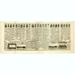
Carte généalogique de la maison de Plantagenette et des ducs Normandie . . .
Genealogical chart of medieval English royal families, seven coats of arms of Edward the Confessor, Edward III, the Plantagenets, the Duke of Normandy and others.Henri Ab...
Date: Amsterdam, 1720
Selling price: ????
Please login to see price!
Sold in 2022
Carte Genealogique des Rois de Portugal & Partie des Differentes Branches qu'ils ont Formee avec le Blazon de leurs Armes & de leurs Alliances.
A genealogical tree of the Portuguese Kings with descriptive, from Chatelain's monumental 7 volume "Atlas Historique". Henri Abraham Chatelain (1684 – 1743) w...
Date: Amsterdam, 1720
Selling price: ????
Please login to see price!
Sold in 2018
Carte genealogique des des rois de France depuis Hugue Capet jusqu'à la famillede Valois . . .
Genealogical chart of kings of France, from Chatelain's monumental 7 volume "Atlas Historique". Henri Abraham Chatelain (1684 – 1743) was a Huguenot pastor of...
Date: Amsterdam, 1720
Selling price: ????
Please login to see price!
Sold in 2018

Carte Historique & Cronologique Pour Servir a L'Histoire des Provinces-Unis des Pais-Bas.
A wonderful genealogical chart and portraits of the rulers of the Netherlands, dating from Charles V in 1558 AD to William III of Orange, till 1702. From “Atlas Histori...
Date: Amsterdam, 1720
Selling price: ????
Please login to see price!
Sold in 2019
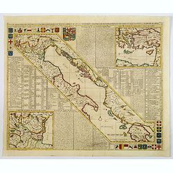
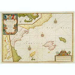
Carte de Géographie des différents Etats de la République de Venise . . .
An interesting map of the Gulf of Venice with inset map of the surroundings of Venice and map of Turkey in upper right corner. Plenty of descriptive French text, from Cha...
Date: Amsterdam, 1720
Selling price: ????
Please login to see price!
Sold in 2021
Le Limbourg, Le Duche de Limbourg, Le Comte de Dalem, Les Seigneures de Fauquemont et de Rolduc. . .
A fine and detailed map of Limburg and Dalem in the southern Netherlands. Based on the work of Nicholas Sanson, the map highlights the counties and lordships of Faquemont...
Date: Amsterdam, 1720
Selling price: ????
Please login to see price!
Sold in 2023
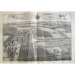
Knowlton Court ye Seat of Sr Thomas D'Aeth Bart & Dame Elizabeth his Wife.
A large copper engraved plan of the manor house. The view is highly detailed, showing buildings, horses, deer, parks, roads, and sailing ships in the background. Below a ...
Date: London, ca 1720
Selling price: ????
Please login to see price!
Sold in 2018
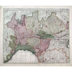
Status Mediolanensis, divisus in Ditiones Mediolanensem, Comum, Cremonam, Paviam, Novaram, Tortonam, Lumellinam et Laudam, una cum Ducatibus Monte Ferrato, Parma, Mutina, Mantua et Mirandula...
A fantastic map of northern Italy, with Aosta in the east, Venice in the west, Trento in the north, and Pisa & Florence in the south. Many famous cities are shown (Mo...
Date: Amsterdam, ca. 1720
Selling price: ????
Please login to see price!
Sold in 2018
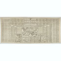
Poliometria Europae Maxime Autem Germaniae ac Finitimorum Locorum.
This unusual thematic chart shows the traveling distances from various European cities in a style that is still used in charts today.JOACHIM OTTENS 1663-1719 - REINER OTT...
Date: Amsterdam, 1720
Selling price: ????
Please login to see price!
Sold in 2020
Accurate Vorstellung der Beruhmten Enge Zwischen der Nord und Ost See dur Sund Genant. . .Copenhagen. . .
A striking and a lovely copper engraved map of Copenhagen and the sound of Sund from Johann Bapt. Homann's "Grosser Atlas.", with original color to map, the vig...
Date: Nuremberg, ca 1720
Selling price: ????
Please login to see price!
Sold in 2019
![Carte d'une Partie des Cantons de Berne, de Fribourg du Pais d Veau et du Valais. . . [together with] Zug, Glarus, Basel, Freiburg, Solothurn, Schaffhausen. . .](/uploads/cache/82506-250x250.jpg)
Carte d'une Partie des Cantons de Berne, de Fribourg du Pais d Veau et du Valais. . . [together with] Zug, Glarus, Basel, Freiburg, Solothurn, Schaffhausen. . .
An exceptionally scarce and decorative set of two out of four regional maps of Switzerland by the renowned Swiss polymath Johann Jakob Scheuchzer (1672-1733). The maps ...
Date: Amsterdam, 1720
Selling price: ????
Please login to see price!
Sold in 2020
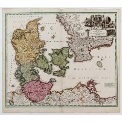
Le Royaume de Danemark divise en ses Provinces. . .
This bold, striking map of Denmark and southern Sweden is engraved to highlight marshes, rivers, cities and towns, shoals and forests. The map is decorated with beautiful...
Date: Amsterdam, ca 1720
Selling price: ????
Please login to see price!
Sold in 2019
Carte généalogique des rois de Navarre de Castille d'Arragon de Portugal et de Grenade, rangée en parallele avec la carte d'Espagne qui distingue les diverses situations de leurs états, leurs armes et alliances.
Interesting sheet with a map of Spain and Portugal and a genealogical tree of the kings of Castile and Navarre, with descriptive French text, from Chatelain's monumental ...
Date: Amsterdam, 1720
Selling price: ????
Please login to see price!
Sold in 2019
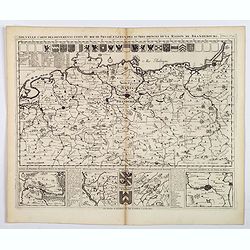
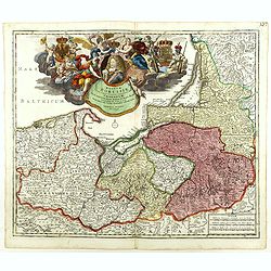
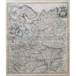
Nouvelle Carte des Differents Etats du Roi de Prusse et de Ceux des Autres Princes de la Maison de Brandebourg.
An interesting map of Germany, focusing on the north. This map covers the area from the French/Dutch borders to Konigsburg (Kaliningrad), including part of modern Poland....
Date: Amsterdam, ca 1720
Selling price: ????
Please login to see price!
Sold in 2021
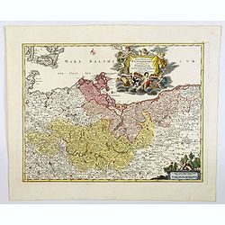
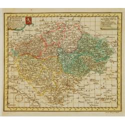
Tabula Marchionatus Brandenburgici et Ducatus Pomerania. . .
A lovely example of the Homann map of Brandenburg and Pomerania, in Germany. The cities of Frankfurt, Brandenburg and Berlin are highlighted in red. This map also include...
Date: Nuremberg, 1720
Selling price: ????
Please login to see price!
Sold in 2019
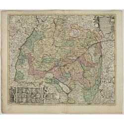
S.R.I. Suevia Circulus et Ducatus, Comprehendes Wirtenbergi Ducatus Augustanum
Decorative and detailed map of Baden-Württemberg and today's Bavarian government district Schwaben. In the lower-left corner is a coat of arms and the upper right corner...
Date: Amsterdam, 1660 - 1720
Selling price: ????
Please login to see price!
Sold in 2023
Carte genealogique de la maison de Courtenay avec les differentes branches quelle a formees accompagnee du Blazon des armes de la plus part des alliances des seigneurs de cette famille.
Genealogical chart, from Chatelain's monumental 7 volume "Atlas Historique". Henri Abraham Chatelain (1684 – 1743) was a Huguenot pastor of Parisian origins. ...
Date: Amsterdam, 1720
Selling price: ????
Please login to see price!
Sold in 2020
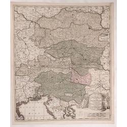
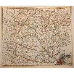
Circuli Austriaci Orientalior Pars in Qua Austria Properia et Abea Dependentes ...
Fine example of Valk's map of Austria, the Gulf of Venice and part of Croatia, Slovenia and Istria. Bounded by the Gulf of Venice and the Golfof Carnero, Stiria and Cher...
Date: Amsterdam, ca. 1720
Selling price: ????
Please login to see price!
Sold in 2023
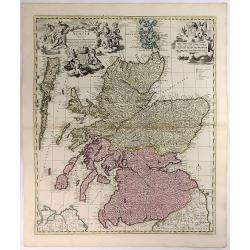
Exactissima Regni Scotiae Tabula. . .
This lovely copper engraved map includes all of Scotland, the Orkney Islands and the New Hebrides, here called the Westerne Iles of Scotland. The map is filled with minut...
Date: Amsterdam, 1720
Selling price: ????
Please login to see price!
Sold in 2021
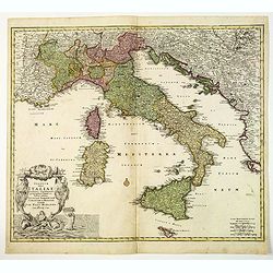
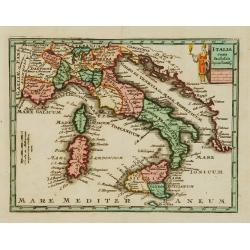
Statuum totius Italiae. . . Siciliae Sardiniae. . .
Johann Baptist Homann's well-engraved map of Italy, Sardinia, Corsica, Malta and Sicily and the western edge of the Adriatic that has an excellent large decorative cartou...
Date: Nuremberg, 1720
Selling price: ????
Please login to see price!
Sold in 2020
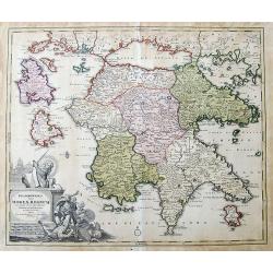
Peloponesus hodie Moreae Regnum...
Large scale map of the Peloponnese, the mainland in the north, and surrounding islands, including Zakynthos and Cephalonia. Shows many details and names, also some notes ...
Date: Nuremberg, ca. 1720
Selling price: ????
Please login to see price!
Sold in 2019
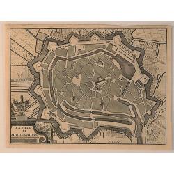
La Ville de Middelbourg.
A bird’s eye view of Middelbourg in the Netherlands, by Jacobus Harrewijn in 1720. Jacobus Harrewijn ( 1660–1727) was an engraver who was mostly active in the Souther...
Date: Brussels, 1720
Selling price: ????
Please login to see price!
Sold in 2020
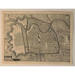
La Ville de Harlem.
A bird’s eye view of Harlem in the Netherlands, by Jacobus Harrewijn in 1720. Jacobus Harrewijn (1660 – 1727) was an engraver who was mostly active in the Southern Ne...
Date: Brussels, 1720
Selling price: ????
Please login to see price!
Sold in 2020
![[Spain & Portugal] Hispania ex Archetypo Roderici Mendez Sylvae et variis Relationibus et Chartis manuscriptis et impressis huius Regni rectificatis per Observationes Sociorum Academiae Scientiarum quae est Parisiis.](/uploads/cache/1151518-250x250.jpg)
[Spain & Portugal] Hispania ex Archetypo Roderici Mendez Sylvae et variis Relationibus et Chartis manuscriptis et impressis huius Regni rectificatis per Observationes Sociorum Academiae Scientiarum quae est Parisiis.
Engraved map with original hand coloring 49.5 x 57 cm. (sheet size 53 x 62 cm.).
Date: Augsburg, 1720
Selling price: ????
Please login to see price!
Sold in 2020
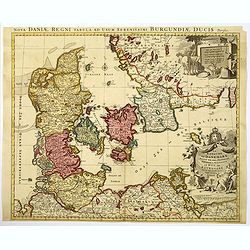
Regni Daniae- in quo sunt Ducatus Holsatia et Slesvicum Insulae Danicae provinciae Iutia Scania Bleringia.
Original hand-colored engraved map. (sheet size 53 x 62 cm.)
Date: Nuremberg, 1720
Selling price: ????
Please login to see price!
Sold in 2020
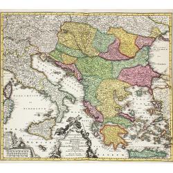
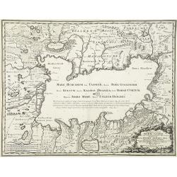
Theatrum belli sive novissima tabula maxima pars Danubii et Hungaria cum alis regnis Graecia, Morea,Archipielago Insula
Engraved map with original hand coloring showing Greece and eastern part of the Mediterranean.
Date: Augsburg 1720
Selling price: ????
Please login to see price!
Sold in 2020
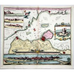
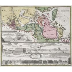
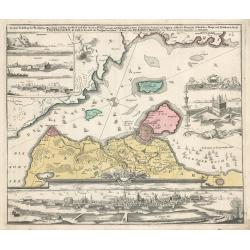
Comitatus Hannoniae in quas quasque Castellanias Balliviatus. . .
This beautiful and detailed map, is centered on the Belgian city of Mons, and includes the towns of Doornick, Halle, Charleroy, Camerijk and Dounay. The larger towns are ...
Date: Nuremberg, ca 1720
Selling price: ????
Please login to see price!
Sold in 2021
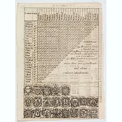
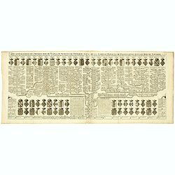
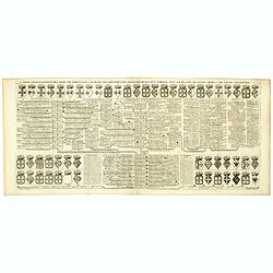
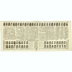
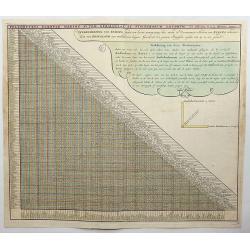
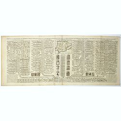
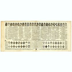
Cornwall.
A triangular distance table of Cornwall, with 21 sets of arms of the county and towns including Truro, St Ives & Fowey, with some statistics about the county. Publish...
Date: London, 1720
Selling price: ????
Please login to see price!
Sold in 2021
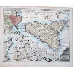
Sicilia antiqua quae et Trinacria dicta nummis Siculis illustrata.
A large, extremely decorative map of the island of Sicily, also showing parts of the Italian peninsula, Malta and a part of Tunisia. A large inset delineates the area of ...
Date: Nuremberg, 1720
Selling price: ????
Please login to see price!
Sold in 2022
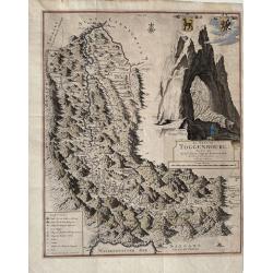
Le Pais de Toggenbourg, desine par Monsr. Jean Jacques Scheurchzer.
A detailed highly decorative map of Toggenbourg, in the Canton of St. Gallen in Switzerland. It presents two coat of arms and a large, fantastic mountain image. Rare.The ...
Date: Leiden, ca 1720
Selling price: ????
Please login to see price!
Sold in 2021
Accurate Vorstellung der Beruhmten Meer-Enge Zwischen der Nord und Ost See der Sund Genant, mit der herumligenden Gegend von Seeland und Schonen nebst der Koniglich-Danischen Haupt und Residentz Stadt Copenhagen...
Homann's map of the area between Copenhagen and Malmoe and the Sund Sound Showing the contiguous Danish & Swedish coastlines, centered on Copenhagen and Landscron. At...
Date: Nuremberg, ca. 1720
Selling price: ????
Please login to see price!
Sold in 2020
Accurate Carte der Uplandischen Scheren mid der Situation und Gegend umb die Konigl. Schwedische Haupt und Residentz Stadt Stockholm.
Johann Christoph Homann - Accurate Carte der Uplandischen Scheren - Nuremberg, ca. 1730. Sweden - Stockholm: Accurate map of the Upland skerries with the situation and ar...
Date: Nürnberg, ca 1720
Selling price: ????
Please login to see price!
Sold in 2021
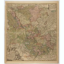
Circulus Electorum Rheni sive Rhenatus Inferior. . .
Map of the center of Germany including the River Rhine, including the cities of Heidelberg, Mainz, Coblenz, etc. In lower left hand corner a large ornamental title cartou...
Date: Amsterdam, c.1720
Selling price: ????
Please login to see price!
Sold in 2021
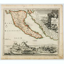
Corcyrae Insula, vulgo Corfu planities unacum parte Greciae.
A scarce map of Greece’s most northerly island, originally drawn by Christoph Weigel, well known as one of the 18th century’s most prolific map makers. To the right o...
Date: Nurnberg, ca 1720
Selling price: ????
Please login to see price!
Sold in 2021
Carte pour servir a l'intelleigence de l'Histoire Eclesiastique et a faire connoitre les persecutions de l'Eglise. . .
Map depicting Egypt and area around the Nile, Ancient world and finally Syria and the coast of Armenian Turkey down through Holy Land and Arabia Desert. Extensive histori...
Date: Amsterdam, 1720
Selling price: ????
Please login to see price!
Sold in 2023
Accurater Grundriß und Prospect Der Kön. Schwed. Reichs. u. Hauptstadt Stockholm
This superb early eighteenth century map of Stockholm in full original hand colour is from Homann’s Maior Atlas Superiore. The map depicts Stockholm as it was at the ...
Date: Nuremburg, 1720
Selling price: ????
Please login to see price!
Sold in 2023
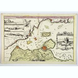
Copenhagen
This map by Johann Homann depicts the city of Copenhagen and its environs from differing perspectives, as the city appeared in the early 18th century.There is evidence of...
Date: Nuremberg, 1720
Selling price: ????
Please login to see price!
Sold in 2023
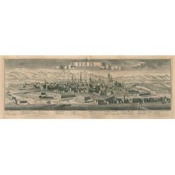
Turin
A fine example of George Balthasar Probst's panoramic bird's-eye-view of Turin, the capital city of Piedmont in northwest Italy. The river Poo, fortified walls, building...
Date: Augsburg, 1720
Selling price: ????
Please login to see price!
Sold in 2023
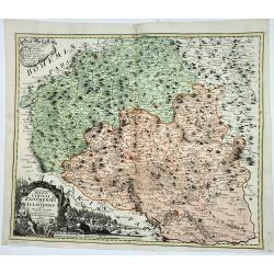
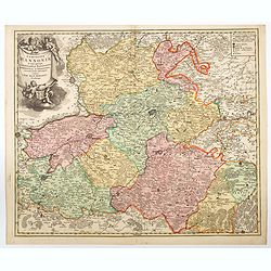
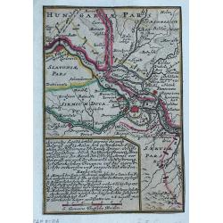
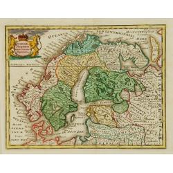
Marchionatus Moraviae Circuli Znoymensis et Iglaviensis
Marchionatus Moraviae Circuli Znoymensis et Iglaviensis quos mandato caesareo accuratè emensus hac Mappa delineatos exhibit. (1720)cartographer: Johann Christoph Mülle...
Date: Nürnberg, 1720
Selling price: ????
Please login to see price!
Sold in 2023
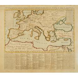
Nouvelle carte des conciles generaux et particuliers ..
Very handsome map of the lands bordering the Mediterranean Sea, including Great Britain and the Black Sea. The map was drawn to show the cities, & towns where Ecclesi...
Date: Amsterdam 1721
Selling price: ????
Please login to see price!
Sold
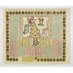
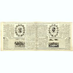
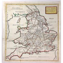
Cart Pour L'Introduction à L'Histoire D'Angleterre ..
Decorative and elaborate map of the British Isles, with portraits of the British Kings and Emperors from 801 (Egbert) to 1702 (Anne). The center map Includes two ancient ...
Date: Amsterdam 1721
Selling price: ????
Please login to see price!
Sold
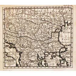
Turquie en Europe.
A nice little map of Greece.
Date: Amsterdam, 1721
Selling price: ????
Please login to see price!
Sold
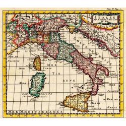
Italie.
A nice little map of Italy.
Date: Amsterdam, 1721
Selling price: ????
Please login to see price!
Sold
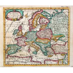
Europe.
A nice little map of the European continent.
Date: Amsterdam, 1721
Selling price: ????
Please login to see price!
Sold
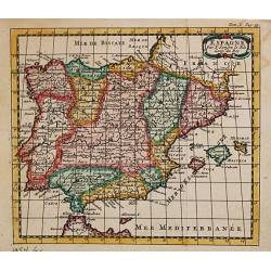
Espagne.
A nice little map of Spain,
Date: Amsterdam, 1721
Selling price: ????
Please login to see price!
Sold
A Map of Hungary and Countries adjacent.
An uncommon English edition of De Wit's map of Scandinavia, 'revised by I.Senex' for inclusion in his atlas of 1721, re-engraved by John Harris. These revisions appear to...
Date: London, 1721
Selling price: ????
Please login to see price!
Sold in 2009
Moscovey in Europe from the latest Observations. . .
Fine, highly detailed map of the regions of European Russia by John Senex. Each region is depicted in original outline color, and a small decorative cartouche is in the t...
Date: London, 1721
Selling price: ????
Please login to see price!
Sold in 2010
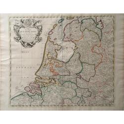
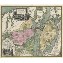
The Dutch Netherlands or the Seven United Provinces Commonly Called Holland.
A map of the Northern part of the Netherlands by John Senex which depicts major cities, including Antwerp, Brugge and Breda, as well as main rivers and lakes in the regio...
Date: London, 1721
Selling price: ????
Please login to see price!
Sold in 2010
Carte marine de la Mer Caspienne...
Map of the Caspian sea with the Volga delta and the city of Astrakhan, with 8 inset maps of islands and coast lines.
Date: Paris, 1721
Selling price: ????
Please login to see price!
Sold in 2015
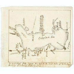
An exact Chart of the Caspian Sea Sent by the Czar Peter 1st to the Royal Academy of Sciences at Paris 1721.
A English contemporary manuscript copy of a map the Caspian Sea drawn by the Czar's special command, Carl van Verden in the year 1719. 1720 and 1721.Around 1718 Russian T...
Date: Probably, England, shortly after 1721
Selling price: ????
Please login to see price!
Sold in 2014
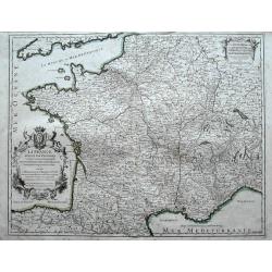
La France divisée par provinces ou sont exactement remarquées toutes les routes des postes du royaume suivant qu'elles sont actuellement établies.
A large and unusual map of France showing the postal routes and post stations includes Switzerland, Luxembourg, parts of Spain, Italy, and Germany.Decorated with a large ...
Date: Paris, 1721
Selling price: ????
Please login to see price!
Sold in 2016
![Flandria et Zeelandia Comitatus. / A Map of the County of Flanders. [Two maps]](/uploads/cache/40598-250x250.jpg)
Flandria et Zeelandia Comitatus. / A Map of the County of Flanders. [Two maps]
[Two maps] First map is a decorative, large map including Flanders and Zeeland. The map, originally engraved in 1641 for Sanderus Flandria Illustrata, and was used at dif...
Date: Amsterdam, ca. 1645 - London, 1721
Selling price: ????
Please login to see price!
Sold in 2018
![Carte Marine De La Mer Caspiene.. [together with] Coste de Perse sur la Mer Caspienne...](/uploads/cache/41944-250x250.jpg)
Carte Marine De La Mer Caspiene.. [together with] Coste de Perse sur la Mer Caspienne...
A two-sheet map "Coste de Perse sur la Mer Caspienne…" together with "Carte Marine de la mer Caspienne. Par Guillaume Delisle Premier Geograp. he du Roy....
Date: Paris, ca 1721
Selling price: ????
Please login to see price!
Sold
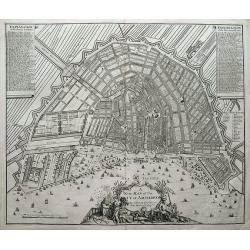
A new map of the city of Amsterdam. . .
A detailed and decorative plan of the city. With numerous streets, windmills, buildings, and sailing ships. 288 streets and 26 buildings are named in the legends. Decorat...
Date: London, 1721
Selling price: ????
Please login to see price!
Sold in 2018
![Carte Marine De La Mer Caspiene.. [Set of two maps.]](/uploads/cache/02934-250x250.jpg)
Carte Marine De La Mer Caspiene.. [Set of two maps.]
Detailed of the Caspian Sea, prepared by Karl van Verden in 1722. Van Verden was a Russian sailor who produced the first accurate map of Caspian. With 8 inset maps.
Date: Paris, 1722
Selling price: ????
Please login to see price!
Sold in 2009
Carte de la Souverainete de Neuchatel et Vallangin. . .
De L'Isle maps were almost always issued with outline color, and it is very unusual to find them in such rich was color.Detailed map prepared by David Francois de Merveil...
Date: Paris, 1722
Selling price: ????
Please login to see price!
Sold in 2011
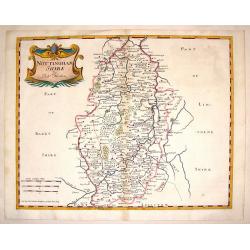
Nottinghamshire.
Detailed map of Nottingham with the early road system, cities & towns,lakes and rivers and forests and mountains. Adorned with an interesting title cartouche. Robert...
Date: London, 1722
Selling price: ????
Please login to see price!
Sold in 2014
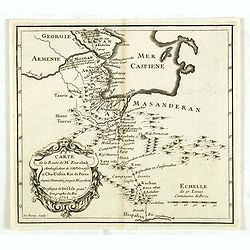
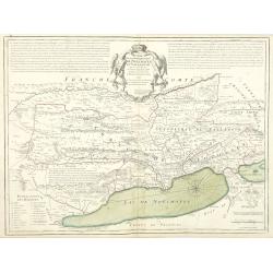
Carte de la route de M. Zurabek, ambassadeur de S.M. polonoise à Cha-Ussein roi de Perse depuis Chamakié jusqu'à Hispahan. . .
Rare map, shows North West Persia and the southern parts of the Caspian Sea with the route of the Polish Ambassador Zurabek to Persia. Engraved by Claude-Auguste de Berey...
Date: Paris, ca. 1722
Selling price: ????
Please login to see price!
Sold in 2014
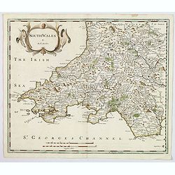
South wales.
A nice copper engraved map of South Wales, produced by Robert Morden for publication in Edmund Gibson's translation of William Camden's "Britannia", first publi...
Date: London, 1722
Selling price: ????
Please login to see price!
Sold in 2021
Accurates lankärtlein worine...Belgrad
Rare map, centered on Belgrade. With a lettered key, probably referring to the siege of Belgrade of 1717.
Date: Augsburg, ca.1722
Selling price: ????
Please login to see price!
Sold in 2023
Suitte des Cotes d'Espagne.. avec les Isles de Mayorque Minorque et d'Yvice.
An attractive map centred on the eastern part of Spain. Includes two inset maps of Minorca and Sofa Bay. Decorative title cartouche on the upper left corner. With the men...
Date: France 1723
Selling price: ????
Please login to see price!
Sold
Novissima et accurata Maris Caspij Fere nobis incogniti Regionumque adiacentium delineatio Iussu PETRI ALEXIJ FIL magni Russorum principis. . .
An uncommon issue of this important and detailed map of the Caspian Sea and countries bordering it, showing settlements and topography and providing soundings around the ...
Date: Rome, Domenico de Rossi, 1723
Selling price: ????
Please login to see price!
Sold in 2010
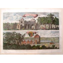
Rudera Sive Reliquia Templi et Monesteri Alfvastrae / Braaborg.
View of the ruins of the 12th century Cistercian monastery at Alvastra. Also, view of the palace at Braaborg. From Dahlbergh's "Suecia Aniqua et Hodierna". Feat...
Date: Stockholm, 1723
Selling price: ????
Please login to see price!
Sold in 2013
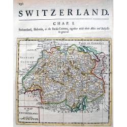
A map of Switzerland.
Uncommon map which we could not identify. Published probably in London in the early 18th century. Subtitled "Switzerland, Helvetia, or the Swiss-Cantons, together wi...
Date: London, c. 1723
Selling price: ????
Please login to see price!
Sold in 2013
Ingratiam Itinerantium Curiosorum Antonini Aug. Itinerarium per Britanniam ...
A general map of Britain, featuring the Roman live and main cross-roads in England and Wales. Published in the “Itinerarium Curiosum” by William Stukeley, An original...
Date: London, 1723
Selling price: ????
Please login to see price!
Sold in 2016
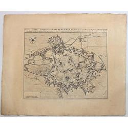
Plan de la Ville et Citadelle de Valenciennes.
Beautiful engraved plan showing the city and the citadel of Valenciennes, drawn in 1709 by Eugène Henry Fricx, a Brussels printer specialized in battles and sieges. Nice...
Date: Amsterdam, 1723
Selling price: ????
Please login to see price!
Sold in 2019
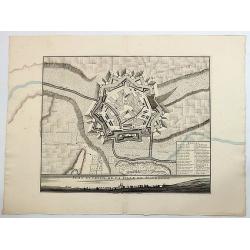
Plan et Profil de la Ville de Maubeuge.
Beautiful engraved plan showing the city of Maubeuge, drawn by Eugène Henry Fricx, a Brussels printer specialized in battles and sieges. Nice copy with large margins. Th...
Date: Amsterdam, 1723
Selling price: ????
Please login to see price!
Sold in 2017
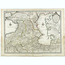
Carte des Pays Voisins de la Mer Caspiene dressee pour l' usage du Roy. . .
Detailed and attractive map focusing on Georgia, Azerbaijan and Armenia. With the imprint "Par Guillaume Delisle Premier Geograp. he du Roy, de l'Academie Royale. 15...
Date: Paris, 15 August 1723
Selling price: ????
Please login to see price!
Sold in 2018
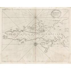
The South Part of Shetland
This decorative copperplate nautical chart was part of the work commissioned by Charles II of England when Samuel Pepys was Secretary to the Admiralty. The work was to ch...
Date: London, 1723
Selling price: ????
Please login to see price!
Sold in 2023
Sueciae Regnum cum vicinis Regionibus.
Uncommon map of Scandinavia. The originally colored title cartouche is surrounded by mythological figures. From Atlas Portatif.
Date: Nuremberg 1724
Selling price: ????
Please login to see price!
Sold
Italia cum Insulis..
Uncommon map of Italy. The originally colored title cartouche is surrounded by mythological figures. From Atlas Portatif.
Date: Nuremberg 1724
Selling price: ????
Please login to see price!
Sold
Königreich Boehmen mit seinen..
Uncommon map of Bohemia. The originally colored title cartouche has a coat-of-arms. From Atlas Portatif.
Date: Nuremberg 1724
Selling price: ????
Please login to see price!
Sold