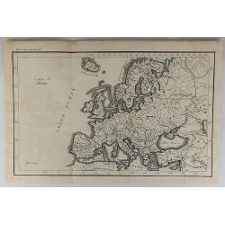
Browse Listings in Europe
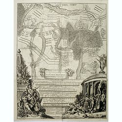
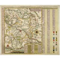
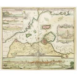
Prospectus pontiss Mariae . . .
Three plates on one sheet. Upper one showing a destroyed Santa Maria Bridge in Rome. Pieter van der Aa was a prolific publisher. He published a.o. "Naaukeurige versa...
Date: Leiden, 1729
Selling price: ????
Please login to see price!
Sold in 2009

Conspectvs basilicae d. Petri, Porticvs . . .
Three plates on one sheet. Upper one showing St. Peter Basilica in Rome. Pieter van der Aa was a prolific publisher. He published a.o. "Naaukeurige versameling der g...
Date: Leiden, 1729
Selling price: ????
Please login to see price!
Sold in 2011
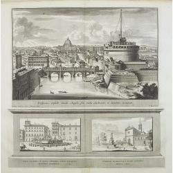
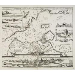
Prospectus Castelli Sancti Angeli . . .
Three plates on one sheet. Upper one showing Santa Maria degli Angeli and St. Peter Basilica in Rome. Pieter van der Aa was a prolific publisher. He published a.o. "...
Date: Leiden, 1729
Selling price: ????
Please login to see price!
Sold in 2009
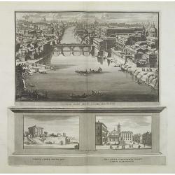
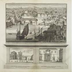
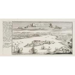
Prospectus Pontis Sixti in Locorvmq adjecentivm . . .
Three plates on one sheet. Upper one showing canal in Rome. Pieter van der Aa was a prolific publisher. He published a.o. "Naaukeurige versameling der gedenkwaardigs...
Date: Leiden, 1729
Selling price: ????
Please login to see price!
Sold in 2009
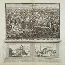
Prospectus Fori Romani. . .
Three plates on one sheet. Upper one showing Forum Romanum in Rome. Pieter van der Aa was a prolific publisher. He published a.o. "Naaukeurige versameling der gedenk...
Date: Leiden, 1729
Selling price: ????
Please login to see price!
Sold in 2009

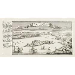
Prospectus Pontis Sixti in Locorvmq adjecentivm . . .
Three plates on one sheet. Upper one showing Coliseum in Rome, in lower part St. Peter's Basilica in the Vatican. Pieter van der Aa was a prolific publisher. He published...
Date: Leiden, 1729
Selling price: ????
Please login to see price!
Sold in 2009
Plan der Glorieuse Veldslag van Malplaquet Gewonnen door de Geallieerde op den 11 September 1709.
Impressive large engraving, etching showing the battle of Malplaquet, published by Isaac van der Kloot after a design of Jan van Vianen (Amsterdam c. 1680 - after 1726).T...
Date: Amsterdam, 1729
Selling price: ????
Please login to see price!
Sold in 2014
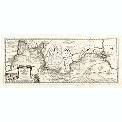
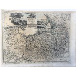
Le Cours de la Riviere de Wolga Anciennement appellee RHA. Selon la Relation d'Olearius.
Map of the Volga River after Olearius' and published by Pieter van der Aa.Olearius's map of the lower Volga is the most important map 17th Century map of the River. Decor...
Date: Leiden, 1729
Selling price: ????
Please login to see price!
Sold in 2016
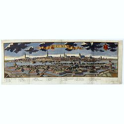
Bremen.
A spectacular panoramic of Bremen, with legends numbered from 1-20 in German. With the title in a banderol.After a design by Friedrich Bernhard Werner (1690-1776) who wa...
Date: Augsburg, 1729
Selling price: ????
Please login to see price!
Sold in 2021
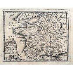
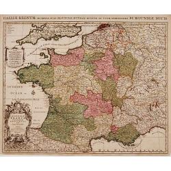
Regnum Galliae Moderna
Charming copper engraved map of France from a rare atlas by Zurner and Weigel. With many place names. Decorated with a title cartouche surrounded by figures.
Date: Nuremberg, 1729
Selling price: ????
Please login to see price!
Sold in 2015
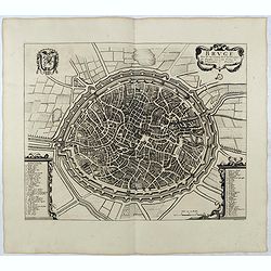
BRUGE een der voornaamste steden van Vlaandren / L'une desPrincipales Villes de Flandre. . .
Detailed plan of Brugge taken from the rare work "Histoire Militaire du Prince Eugene de Savoye, du Prince et Duc de Marlborough, et du Prince de Nassau-Frise" ...
Date: The Hague, Isaac van der Kloot, 1729
Selling price: ????
Please login to see price!
Sold in 2015
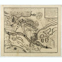
Plan de la Glorieuse Bataille donnee le 16 aout, 1717. Proche de Belgrade...
Title also in Dutch: ""Plan der Roemrugtige Veldslag Voorgevallen den 16 Augustus 1717 Digt by Belgrade ". Oriented to the southeast. Page placement in low...
Date: The Hague, van der Kloot, 1729
Selling price: ????
Please login to see price!
Sold in 2022
Plan der Glorieuse Veldislag van Malplaquet
A plan of the Battle of Malplaquet gained by the Allies Sep.11th 1709 , by the Duke of Marlborough. It was the last great battle in the War of the Spanish Succession (170...
Date: Paris, 1729
Selling price: ????
Please login to see price!
Sold in 2020
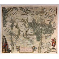
Plan de la Bataille D'Oudenaerde.
A plan of the Battle of Oudenard fought on July 11th 1708. A finely engraved plan with excellent detail of the fortifications of Oudenaerde in Belgium. Full hand coloring...
Date: Paris, 1729
Selling price: ????
Please login to see price!
Sold in 2018
Plan Van de Attaque Van Ryssel & Plan de l'Attaque de Lille
Plans of the attacks on Ryssel/Lille on October 22nd, 1708 by the Duke of Marlborough. It was one of the last great battles in the War of the Spanish Succession (1701–1...
Date: Paris, 1729
Selling price: ????
Please login to see price!
Sold in 2023
Carte du Gouvernement de L'Isle de France...
A fine map of the Isle de France (Paris) region of France by Peter Van Der Aa in Paris. From the book: “La Geographie Moderne, Naturelle, Historique & Politique” ...
Date: Leiden, 1729
Selling price: ????
Please login to see price!
Sold in 2016
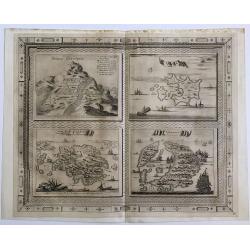
Bergh Cinthus ; Sara ; Eylant Cerigo ; Santorini
A beautiful copper engraving by Van Der Aa of 4 Greek islands, all with a very nicely designed border.
Date: 1729
Selling price: ????
Please login to see price!
Sold in 2016
Grande Pologne et Prusse avec les frontières de la Misnie, Lusace, Moravie et Lithuanie
Fine map of Poland. This well executed engraving was published in 1729 and 1727 by Pieter van der AA, in Leiden in "Les Voyages tres-curieux et tres-renommez faits e...
Date: Leiden, 1729
Selling price: ????
Please login to see price!
Sold in 2020
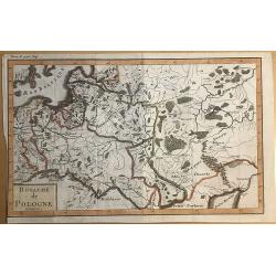
Royaume de Pologne.
Striking map of Poland. It is from “METHODE POUR ETUDIER L’HISTOIRE” by L’Abbe Lenglet du Fresnoy, pulished in Paris in 1729. The map is quite rare and is not now...
Date: Paris, 1729
Selling price: ????
Please login to see price!
Sold in 2019
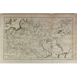
Royaume de Pologne.
Striking map of Poland. It is from “METHODE POUR ETUDIER L’HISTOIRE” by L’Abbe Lenglet du Fresnoy, published in Paris in 1729. The map is quite rare and is not no...
Date: Paris, 1729
Selling price: ????
Please login to see price!
Sold in 2018
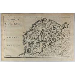
Scandinavie ou Royaume du Nort.
Striking map of Scandinavia. It is from “METHODE POUR ETUDIER L’HISTOIRE” by L’Abbe Lenglet du Fresnoy, published in Paris in 1729. The map is quite rare and is n...
Date: Paris, 1729
Selling price: ????
Please login to see price!
Sold in 2018

Carte du Royaume de France.
A striking map of France, from the “METHODE POUR ETUDIER L’HISTOIRE” by L’Abbe Lenglet du Fresnoy, published in Paris in 1729. The map is quite rare and is not no...
Date: Paris, 1729
Selling price: ????
Please login to see price!
Sold in 2019
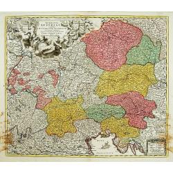
Carte de l'Empire d'Allemagne.
A striking map of Germany, from “METHODE POUR ETUDIER L’HISTOIRE” by L’Abbe Lenglet du Fresnoy, published in Paris in 1729. The map is quite rare and is not on or...
Date: Paris, 1729
Selling price: ????
Please login to see price!
Sold in 2019
Methode Pour Etudier L'Histoire.
A striking map of Germany, from “METHODE POUR ETUDIER L’HISTOIRE” by L’Abbe Lenglet du Fresnoy, published in Paris in 1729. The map is quite rare and is not now o...
Date: Paris, 1729
Selling price: ????
Please login to see price!
Sold in 2021
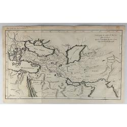
Carte pour la Route de Xerxes dans la Grece et Pour l'Expedition du Jeune Cyprus et la Retraite des Dix Mille.
A striking map of Greece. The map for the Route of Xerxes in Greece and For the Expedition of the Young Cyprus, and the Retreat of the Ten Thousand. It is from “METHODE...
Date: Paris, 1729
Selling price: ????
Please login to see price!
Sold in 2020
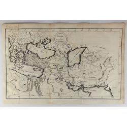
Empire et Conquetes d'Allexandre.
A striking map of Greece during the time of 'Alexander the Great,' showing his conquests. It is from “METHODE POUR ETUDIER L’HISTOIRE” by L’Abbe Lenglet du Fresno...
Date: Paris, 1729
Selling price: ????
Please login to see price!
Sold in 2019
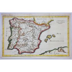
Carte du Royaume d'Espagne.
A striking map of Spain and Portugal. It is from METHODE POUR ETUDIER L’HISTOIRE by L’Abbe Lenglet du Fresnoy, published in Paris in 1729. The map is quite rare and i...
Date: Paris, 1729
Selling price: ????
Please login to see price!
Sold in 2020
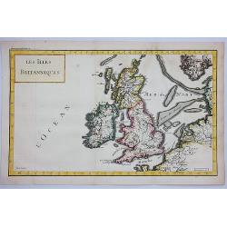
Les Iles Britanniques.
A striking map of the British Isles. It is from METHODE POUR ETUDIER L’HISTOIRE by L’Abbe Lenglet du Fresnoy, published in Paris in 1729. The map is quite rare. It wa...
Date: Paris, 1729
Selling price: ????
Please login to see price!
Sold in 2021
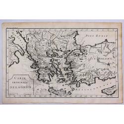
Carte Generale de la Grece.
A striking map of Greece. It is from METHODE POUR ETUDIER L’HISTOIRE by L’Abbe Lenglet du Fresnoy, published in Paris in 1729. The map is quite rare and is not now, n...
Date: Paris, 1729
Selling price: ????
Please login to see price!
Sold in 2017
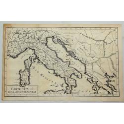
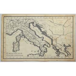
Carte D'Italie pour L'Histoire Moderne.
A striking map of Italy and European Turkey from the “METHODE POUR ETUDIER L’HISTOIRE” by L’Abbe Lenglet du Fresnoy, published in Paris in 1729. The map is quite ...
Date: Paris, 1729
Selling price: ????
Please login to see price!
Sold in 2019
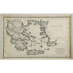
Carte de la Grece pour L'intelleigence de la Guerre de Troye.
A striking map of Greece shown at the time of the war of Troy from the “METHODE POUR ETUDIER L’HISTOIRE” by L’Abbe Lenglet du Fresnoy, published in Paris in 1729....
Date: Paris, 1729
Selling price: ????
Please login to see price!
Sold in 2020
Carte D'Italie Pour L'Histoire Romaine.
A striking map of Italy shown at the time of the Romans from the “METHODE POUR ETUDIER L’HISTOIRE” by L’Abbe Lenglet du Fresnoy, published in Paris in 1729. The m...
Date: Paris, 1729
Selling price: ????
Please login to see price!
Sold in 2023
![Troisieme plan de la ville de Paris, son étendiie et les bourgs dont elle êtoit environnée sous le regne de Loüis le Jeune, VIIe du nom [...] par M.L.C.D.L.M.](/uploads/cache/42142-250x250.jpg)
Troisieme plan de la ville de Paris, son étendiie et les bourgs dont elle êtoit environnée sous le regne de Loüis le Jeune, VIIe du nom [...] par M.L.C.D.L.M.
Engraved plan of Paris, oriented to the North with a compass rose (upper part) and equipped with a double scale (400 geometrical steps and 1000 not common) with a brief c...
Date: Paris, 1729
Selling price: ????
Please login to see price!
Sold
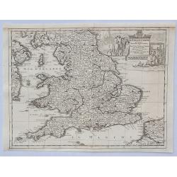
L'Angleterre Suivant les Nouvelles Observations. . .
An attractive map of England and Wales, showing part of the French coast and a small part of Scotland and Ireland, it has a decorative cartouche with scenes of English tr...
Date: Leiden, 1729
Selling price: ????
Please login to see price!
Sold in 2023
Cercle D'Autriche suivant les Nouvelles Observations.
An attractive, detailed map of Austria, part of Italy and the Czech Republic. Features a decorative cartouche with arms and a native holding a spear. Also portrait of a p...
Date: Amsterdam, 1729
Selling price: ????
Please login to see price!
Sold in 2021
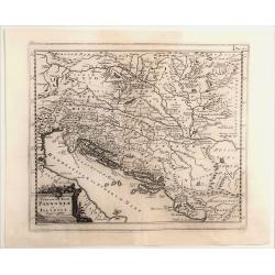
Veteris et Nova Pannonia et Illyrici.
Engraved map of the Dalmatian coast from Italy to Greece. From "Introductionis in Universam Geographiam". Embellished with a decorative title cartouche. Phili...
Date: Amsterdam, 1729
Selling price: ????
Please login to see price!
Sold in 2021
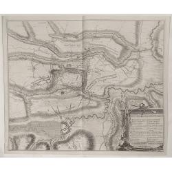
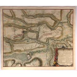
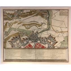
Plan der Veldslag van Oudernaerde den 11 July, 1708 ...
Fine detailed plan of the fortifications of Oudenaarde in Belgium by Dumont in 1729. Engraved by James Basire. Features a striking title cartouche with weapons. James...
Date: Paris, 1729
Selling price: ????
Please login to see price!
Sold in 2023
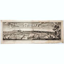
Aurick (Aurich)
A spectacular panoramic view of Aurich in the East Frisian region of Lower Saxony, with legends numbered 1-4 in German. With the title in a banderol.After a design by Fri...
Date: Augsburg, 1729
Selling price: ????
Please login to see price!
Sold in 2020
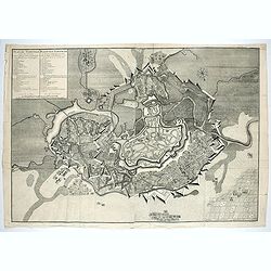
Plan de Temiswar … Plan van Temiswar.
Title also in Dutch: "Plan der Roemrugtige Veldslag Voorgevallen den 16 Augustus 1717 Digt by Belgrade ". Oriented to the southeast. Page placement in lower rig...
Date: The Hague, 1729
Selling price: ????
Please login to see price!
Sold in 2022
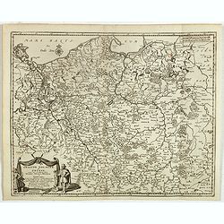
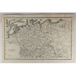
La Prusse. Suivant les Nouvelles Observations de Messrs. de l'Academie Royale des Sciences, etc. Augmentées de Nouveau. A Leide, chez Pierre vander Aa. - Avec Privilege.'
Decorative example of Van der Aa's map of Prussia, including Poland and Lithuania.
Date: Leiden, 1729
Selling price: ????
Please login to see price!
Sold in 2023
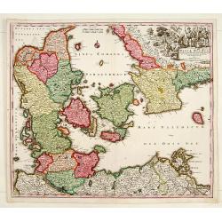
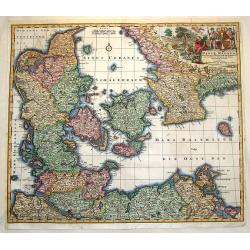
Daniae Regnum.
No text on verso.
Date: Nuremberg 1730
Selling price: ????
Please login to see price!
Sold
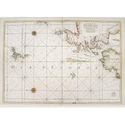
Carte de la mer d'Ecosse../d'Irlande
Sea chart depicting northern tip of Ireland and Scotland. East to top.
Date: Paris 1730
Selling price: ????
Please login to see price!
Sold
" LE ROYAUME DE France Divisé en Toutes ses Provinces et ses acquisitions."
An Amsterdam version of the general map of France by Hubert Jaillot. The scale cartouche upper left has the name of the publisher : P.Mortier et Compagnie.
Date: Amsterdam, ca. 1730
Selling price: ????
Please login to see price!
Sold in 2009
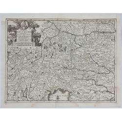
Germania Austriaca.
Decorative and detailed map showing northern part of Italy including Milan, Mantua, Venice. Also showing today's Czech Republic, Slovakia, Hungary, Bavaria (in Germany), ...
Date: Nuremberg 1730
Selling price: ????
Please login to see price!
Sold
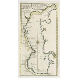
Suite des Costes d?Espagne et Barbarie.
A chart showing the coast of Spain from Cartagena to Denia with Ibiza and Formentera and the coast of North Africa With 4 insets with coastal details and decorated with t...
Date: Paris, 1727-1730
Selling price: ????
Please login to see price!
Sold
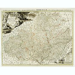
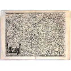
Carte générale du marquisat de Moravie..
Very detailed map of Moravia.
Date: Amsterdam, 1730
Selling price: ????
Please login to see price!
Sold
MEYLAND. F. B. Werner delin. Haered. Ieremiae Wolff excud.
A spectacular panoramic view of Milan designed by Friedrich Bernhard Werner (1690-1776). With the title in a banderol at the head, flanked on the right by the crowned cit...
Date: Augsbourg , ca. 1730
Selling price: ????
Please login to see price!
Sold
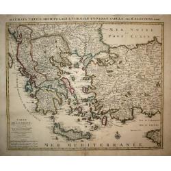
Carte de la Grece.
A striking, large map detailing Greece, the western part of Turkey and extending to show Albania, Macedonia and part of Cyprus. Latin title at top "Accurata Totius A...
Date: Amsterdam, 1730
Selling price: ????
Please login to see price!
Sold in 2008
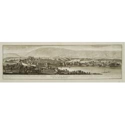
Vue de la ville de Geneve du coté du septentrion.
Decorative panoramic view of Geneva, after Robertus Gardelle and engraved by J.G.Seiller. From Jacob Spon Histoire de Genève. Rectifiée & augmentée par d'amples no...
Date: Geneva, Fabri & Barrillot, 1730
Selling price: ????
Please login to see price!
Sold

Veuë de la ville de Geneve du coté du midy.
Decorative panoramic view of Geneva, after Robertus Gardelle and engraved by Daudet. From Jacob Spon Histoire de Genève. Rectifiée & augmentée par d'amples notes..
Date: Geneva, Fabri & Barrillot, 1730
Selling price: ????
Please login to see price!
Sold
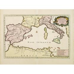
Expeditiones Hannibalis per Hispaniam, Galliam, Italiam, Africam &cc..
Map covering the Eastern part of the Mediterranean Basin as far as the Adriatic Sea. It illustrates the route of Hannibal through Northern Africa and southern Europe as f...
Date: Amsterdam 1730
Selling price: ????
Please login to see price!
Sold
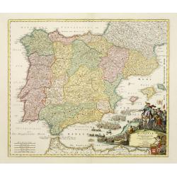
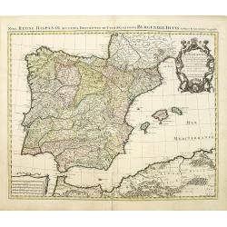
Regnorum Hispaniae et Portugalliae tabula Generailis..
Fine map of Spain and Portugal, including Majorca and Minorca. Exceptionally detailed, but the most remarkable feature of the engraving is the large title-piece showing a...
Date: Nuremberg 1730
Selling price: ????
Please login to see price!
Sold
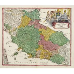
Status ECCLESIASTICI magnique ducatus Florentini..
Fine example in striking colors, of Central Italy, from Ferrara, Parma and Cremona to Territorium Romanum, centered on Florence and Sienna and showing Rome. Decorative la...
Date: Nuremberg 1730
Selling price: ????
Please login to see price!
Sold
Accurate Geographische delineation der Dioeces und des Ammtes DRESDEN. . .
Uncommon and decorative map of the area 25km around Dresden, reaching to Meissen, Königstein and Dippoldiswalde, prepared by Adam Friedrich Zürner. With an extensive ke...
Date: Amsterdam, 1730
Selling price: ????
Please login to see price!
Sold in 2011
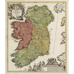
Hiberniae regnum..
A detailed and decorative map of Ireland, with an attractive uncolored title cartouche.
Date: Nurnberg 1730
Selling price: ????
Please login to see price!
Sold
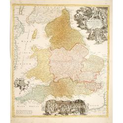
Regnum Angliae..
A detailed and decorative map of England, with an attractive uncolored title cartouche. Made after Visscher.
Date: Nurnberg 1730
Selling price: ????
Please login to see price!
Sold
Reduction De La Carte De La Mer Caspienne..
Uncommon map of the Caspian Sea. Engraved by de Berey.
Date: Paris c.1730
Selling price: ????
Please login to see price!
Sold
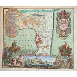
Accurate Vorstellung der Beruhmten... der Königlich Dähnischen..
A map of the Sond between Sweden and Denmark and its approach into Copenhagen. With a bird's eye-view of the Danish capital at the bottom.Surrounding the map are three in...
Date: Nuremberg , ca. 1730
Selling price: ????
Please login to see price!
Sold
Protoparchiae Mindelhemensis nova tabula geographica...
Detailed map of the area 15km around Mindelheim in southern Germany with large cartouche with cherubs and coat of arms.In the right hand side inset prospect of Mindelheim...
Date: Nuremberg , ca. 1730
Selling price: ????
Please login to see price!
Sold in 2013
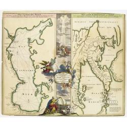
Geographica Nova ex Oriente gratiosissima, duabus tabulis specialissimis contenta, quarum una Mare Caspium..
Map of the Caspian Sea and the peninsula of Kamchatka (Jedso) in northeast Asia on one sheet.Separated by an attractive panel with figurative title cartouche, cherubs, an...
Date: Nuremberg 1730
Selling price: ????
Please login to see price!
Sold
Imperii Moscovitici pars Australis..
Detailed map centered on Moscow.
Date: Augsburg 1730
Selling price: ????
Please login to see price!
Sold
Daniae Regnum cum Ducatu Holstiae et Slesvici.
Fine copper engraved map, hand-colored in outline & wash, featuring Denmark, with its neighbouring counties around the Baltic Sea and Schagerack. Map has a decorative...
Date: Augsburg, 1730
Selling price: ????
Please login to see price!
Sold in 2013
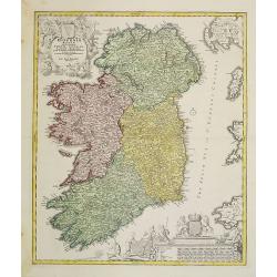
Hiberniae regnum. . .
A detailed and decorative map of Ireland, with an attractive uncolored title cartouche.
Date: Nurnberg 1730
Selling price: ????
Please login to see price!
Sold in 2010
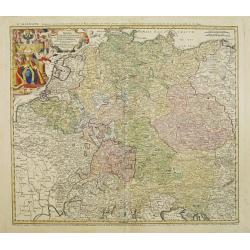
Imperii Romano Germanici. . .
A beautifully colored regional map of the XVIII century German Empire.Ornamental title cartouche in the upper left has been hand colored in recent colors.
Date: Nuremberg, 1730
Selling price: ????
Please login to see price!
Sold in 2008
Milazzo olim Mylae, munitissimum Siciliae castellum.
Exceptional plan and view of the city of Milazzo, in Sicily. One of the most beautiful and sought after views from Seutter. A few imperfections, exceptional old colors, p...
Date: Augsburg, 1730
Selling price: ????
Please login to see price!
Sold in 2013
Prospect von S. Petersburg und der Insul Retufari.
Decorative view of Saint Petersburg, with a description and key to the left.
Date: Augsburg, 1730
Selling price: ????
Please login to see price!
Sold in 2008
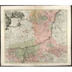
L'Eveche et L'Etat de Liege Avec les appartenances designées dans les pais voisins Delineation nouvelle et exacte Aux depens de Matthieu Seutter
Beautiful cooper engraved map of the central part of Belgium and parts of the Netherlands by M. Seutter. Showing the area around Liège and Maastricht. The nice...
Date: Augsburg, 1730
Selling price: ????
Please login to see price!
Sold in 2009
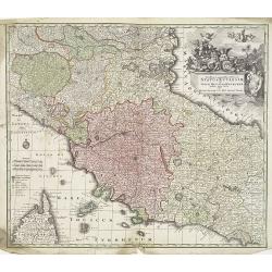
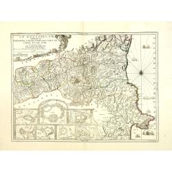
Novissima et accuratissima Delineatio Status Ecclesiae, et Magni Ducatus Hetruriae . . .
Striking map of Central Italy, from Mantua, Cremona, Piacenza and Ferrara in the north to Roma in the South and including Ancon on the Adriatic. Centered on Florence and ...
Date: Paris, 1730
Selling price: ????
Please login to see price!
Sold in 2009
Prospect von S. Petersburg und der Insul Retufari.
Bird's-eye view of the island Retufari, with according to the key the town of Saint Petersburg (A) in background. With a description in German to the left.
Date: Augsburg, 1730
Selling price: ????
Please login to see price!
Sold in 2009
Accurate Vorstellung der Beruhmten ? der Königlich Dähnischen ?
A map of the Sond between Sweden and Denmark and its approach into Copenhagen. With a bird's eye-view of the Danish capital at the bottom.Surrounding the map are three in...
Date: Nuremberg , ca. 1730
Selling price: ????
Please login to see price!
Sold in 2009
Belgii Regii accuratissima Tabula, Auctore Fredericum de Witt. . .ex Officina R. et J. Ottens.
Map of the present-day Belgium. Ottens acquired the copper plate from Visscher and re-issued the map, adding his address to the title cartouche. Uncommon.Joachim Ottens (...
Date: Amsterdam, 1730
Selling price: ????
Please login to see price!
Sold in 2010
Ducatus Geldriae Nova Tabula In Tertachias Noviomagii, Arnhemii, Ruremondae in Zutphaniae Comitatum.
This is a uncommon re-issue of the copperplate of Nicolas Visscher. Including the area of Gelderland, Overijssel and Noord Limburg.Joachim Ottens (1663 - 1719) and his so...
Date: Amsterdam, 1730
Selling price: ????
Please login to see price!
Sold in 2020
Mappa geographica illustris Helvetiorum reipublicæ Bernensis: cum adjacentibus pagorum et dynastiarum confiniis accurate delineata.
Striking map of Switzerland by Matthew Seutter.
Date: Augsburg, ca. 1730
Selling price: ????
Please login to see price!
Sold in 2010
Novissima et accuratissima XVII Provinciarum Germania Inferior Tabula.
Finely detailed map of the Netherlands by Frederick de Wit. A large legend cartouche is in the top left, is the family crest and dedication to John Munter, mayor of Amste...
Date: Amsterdam, 1730
Selling price: ????
Please login to see price!
Sold in 2010
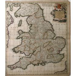
Accuratiffima Angliae Regni et Walliae Principatus Defcriptio Diftinete divifa in Omnes fuas Provincias et Edita.
A detailed map of Great Britain, Scotland and Wales by Frederick De Witt. Map includes islands off the coast of Britain and a small portion of the Northern Coast and the ...
Date: Amsterdam, 1730
Selling price: ????
Please login to see price!
Sold in 2010
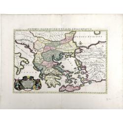
Antiquorum Illyrici Orientalis ...
Fine map of ancient Greece, Crete and Turkey by Sanson and published by the Covens and Mortier firm. Shows many ancient Greek cities and sites, such as Nicropolis, Athens...
Date: Amsterdam, 1730
Selling price: ????
Please login to see price!
Sold in 2010
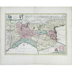
Italia Gallicae Sive Galliae Cisalpinae. . .
Map of the region of Northern Italy, highlighting the areas of Gallia Transpadana, the region inhabited by the Celts between the Padus (now called Po River) and the Swiss...
Date: Amsterdam, 1730
Selling price: ????
Please login to see price!
Sold in 2010
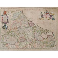
Belgica in Provincias Quatuor et Populos Viginti aut circiter. . .
This map, published by Covens and Mortier, covers present-day Belgium, once known as Belgica, and the surrounding provinces. In the 1st century AD, the provinces of Gaul ...
Date: Amsterdam, 1730
Selling price: ????
Please login to see price!
Sold in 2010
Nova Regni Hispaniae accurata descriptio ad u sum serenissimi Burgundiae ducis.
Prepared by G.de L'Isle.The Amsterdam publishing firm of Covens and Mortier (1721 – c. 1862) was the successor to the extensive publishing empire build by Frenchman Pie...
Date: Amsterdam, 1730
Selling price: ????
Please login to see price!
Sold in 2010
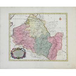
Le Roussillon Subdivisé en Cerdagne, Cap Sir, Conflans, Vals de Carol et de Spir ou se trouve encore le Lampourdan, Faisant Partie de la Catalogne.
Striking map of the region including part of the southeastern French Mediterranean coastline and neighboring Catalonia.This very decorative map includes in the lower left...
Date: Paris, 1730
Selling price: ????
Please login to see price!
Sold