Browse Listings in Europe
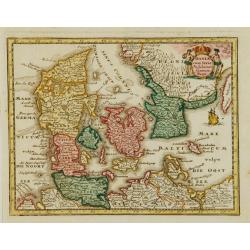
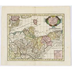
Daniae cum Serie Insularum?
Uncommon map of Denmark. The originally colored title cartouche is surrounded by mythological figures. From Atlas Portatif.
Date: Nuremberg 1724
Selling price: ????
Please login to see price!
Sold
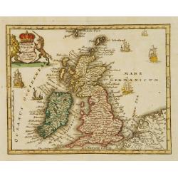
Angliae Scotiae et Hiberniae Regna..
Uncommon map of Great Britain and Ireland. The originally colored title cartouche is surrounded by mythological figures. From Atlas Portatif.
Date: Nuremberg 1724
Selling price: ????
Please login to see price!
Sold
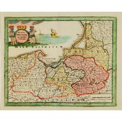
Regni Prussiae accurata delineatio.
Uncommon map of Prussia. The originally colored title cartouche is surrounded by mythological figures. From Atlas Portatif.
Date: Nuremberg 1724
Selling price: ????
Please login to see price!
Sold
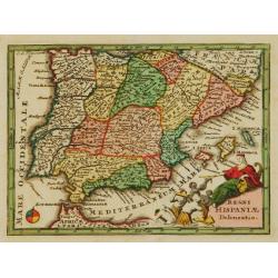
Regni Hispaniae Delineatio.
Uncommon map of Spain. The originally colored title cartouche is surrounded by mythological figures. From Atlas Portatif.
Date: Nuremberg 1724
Selling price: ????
Please login to see price!
Sold
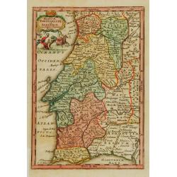
Regnum Portugalliae et Algarbiae..
Uncommon map of Portugal and Gibraltar. The originally colored title cartouche is surrounded by mythological figures. From Atlas Portatif.
Date: Nuremberg 1724
Selling price: ????
Please login to see price!
Sold
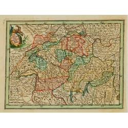
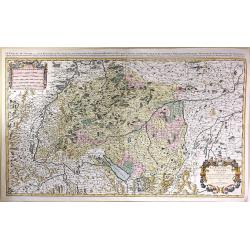
Novissima Foederatorum Helvetiorum Tabula.
Uncommon map of Switzerland. The originally colored title cartouche is surrounded by mythological figures. From Atlas Portatif.
Date: Nuremberg 1724
Selling price: ????
Please login to see price!
Sold
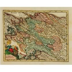
Imperium Moscoviae.
Uncommon map of Russia. The originally colored title cartouche is surrounded by mythological figures. From Atlas Portatif.
Date: Nuremberg 1724
Selling price: ????
Please login to see price!
Sold
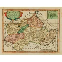
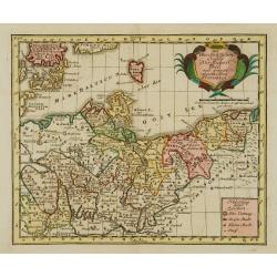
Das Hertzogthum Mecklenburg..
Uncommon map of the duchy of Mecklenburg. With originally colored title cartouche. From Atlas Portatif.
Date: Nuremberg 1724
Selling price: ????
Please login to see price!
Sold
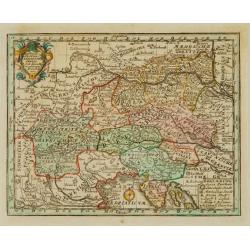
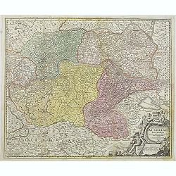
Teutschlandes Oesterreichischer Creiss..
Uncommon map of Austria. The originally colored title cartouche is surrounded by floral decorations. From Atlas Portatif.
Date: Nuremberg 1724
Selling price: ????
Please login to see price!
Sold
Des OberSächßischen Creißes Nordlicher Theil..
Uncommon map of Obersachsen. With originally colored title cartouche. From Atlas Portatif.
Date: Nuremberg 1724
Selling price: ????
Please login to see price!
Sold
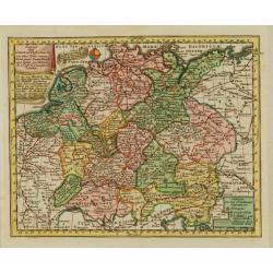
Extract einer General Post-Charte..
Uncommon post route map of Germany. With originally colored title cartouche. From Atlas Portatif.
Date: Nuremberg 1724
Selling price: ????
Please login to see price!
Sold
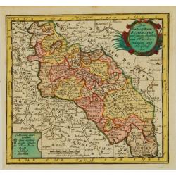
Das Hertzogthum Schlesien..
Uncommon map of Northern Germany. The originally colored title cartouche. From Atlas Portatif.
Date: Nuremberg 1724
Selling price: ????
Please login to see price!
Sold
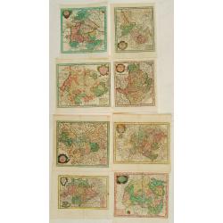
8 Maps of German provinces..
Group of 8 uncommon maps of German provinces. With originally colored title cartouches. From Atlas Portatif.
Date: Nuremberg 1724
Selling price: ????
Please login to see price!
Sold

Veduta interiore.. Gran Basilica di S.Pietro in Vaticano.
A beautifully engraved and richly decorated architectural print of the interior of St.Pieter Church in Rome. With a key (a-z) in lower corners.Joan Blaeu published during...
Date: Amsterdam, 1663/1704/1724
Selling price: ????
Please login to see price!
Sold
Des OberSächßischen Creißes Nordlicher Theil..
Uncommon map of Obersachsen. The originally colored title cartouche is surrounded by mythological figures. From Atlas Portatif.
Date: Nuremberg 1724
Selling price: ????
Please login to see price!
Sold in 2015
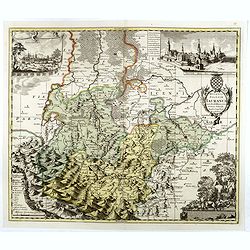
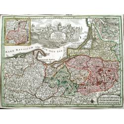
Archiducatus Austriae inferioris . . .
Decorative map of Austria, centered on the course of the Danube River and Vienna. Shows the region from Enss and sTeyr to Presburg and Altenburg.
Date: Nuremberg, 1724
Selling price: ????
Please login to see price!
Sold in 2014
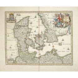
Dania Jutia Holsatia, Scandia...
An attractive map of Denmark and adjacent coastlines. Includes elaborate cartouche and 2 coats of arms.Nice old coloring, drawn and engraved by Michael Kauffer.(inscripti...
Date: Nuremberg, 1724
Selling price: ????
Please login to see price!
Sold in 2012
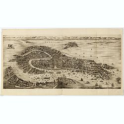
Venetia.
Folding panoramic view showing in great detail the harbour and city of Venice.Engraved in 1670 by Julius Milheuser but it was never used in an atlas and only a few copies...
Date: Amsterdam, 1704-1724
Selling price: ????
Please login to see price!
Sold in 2015
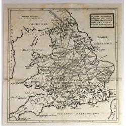
In Gratiam Itinerantium Curiosorum Antonini Aug. Itinerarium per Britanniam.
An informative map of Great Britain, showing roads, rivers, cities and towns. Place names given in both Latin and English.Published by Herman Moll in 1724 in “A New Des...
Date: London, 1724
Selling price: ????
Please login to see price!
Sold in 2016
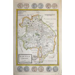
Warwick Shire by H. Moll Geographer
An interesting and attractive 18th century copperplate map of the county of Warwickshire divided into hundreds.It shows a title panel, scale and lists the administrative ...
Date: London, 1724
Selling price: ????
Please login to see price!
Sold in 2016
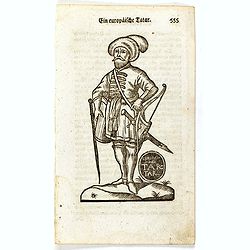
Ein Europäische Tatar.
Finely executed wood block print taken from the "Neueröffnetes Amphitheatrum Worinnen. . .", which book was issued in five parts between 1722 and 1728, with vo...
Date: Erfurt, ca. 1724
Selling price: ????
Please login to see price!
Sold in 2016
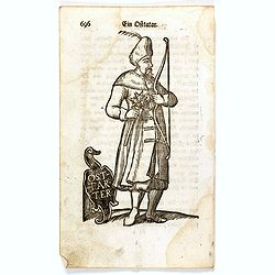
Ein Ostarter.
Finely executed wood block print taken from the "Neueröffnetes Amphitheatrum Worinnen. . .", which book was issued in five parts between 1722 and 1728, with vo...
Date: Erfurt, ca. 1724
Selling price: ????
Please login to see price!
Sold in 2016
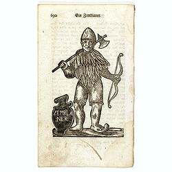
Ein Zemblaner.
Finely executed wood block print taken from the "Neueröffnetes Amphitheatrum Worinnen. . .", which book was issued in five parts between 1722 and 1728, with vo...
Date: Erfurt, ca. 1724
Selling price: ????
Please login to see price!
Sold in 2016
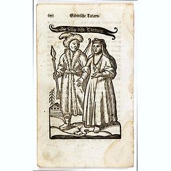
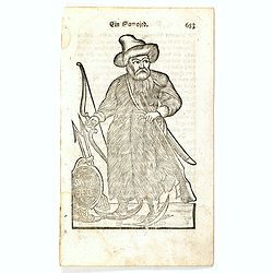
Siberifche Tartarn.
Finely executed wood block print taken from the "Neueröffnetes Amphitheatrum Worinnen. . .", which book was issued in five parts between 1722 and 1728, with vo...
Date: Erfurt, ca. 1724
Selling price: ????
Please login to see price!
Sold in 2016
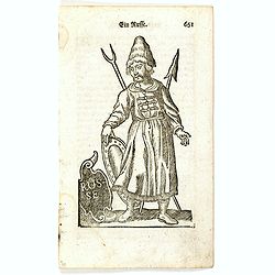
Ein Russe.
Finely executed wood block print taken from the "Neueröffnetes Amphitheatrum Worinnen. . .", which book was issued in five parts between 1722 and 1728, with vo...
Date: Erfurt, ca. 1724
Selling price: ????
Please login to see price!
Sold in 2016
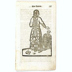
Eine Tartarin.
Finely executed wood block print taken from the "Neueröffnetes Amphitheatrum Worinnen. . .", which book was issued in five parts between 1722 and 1728, with vo...
Date: Erfurt, ca. 1724
Selling price: ????
Please login to see price!
Sold in 2016
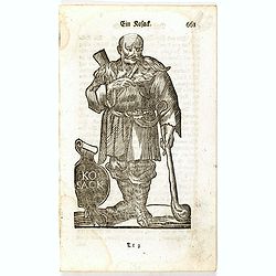
Ein Kosack.
Finely executed wood block print taken from the "Neueröffnetes Amphitheatrum Worinnen. . .", which book was issued in five parts between 1722 and 1728, with vo...
Date: Erfurt, ca. 1724
Selling price: ????
Please login to see price!
Sold in 2016
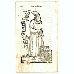
Eine Ostiackin.
Finely executed wood block print taken from the "Neueröffnetes Amphitheatrum Worinnen. . .", which book was issued in five parts between 1722 and 1728, with vo...
Date: Erfurt, ca. 1724
Selling price: ????
Please login to see price!
Sold in 2016
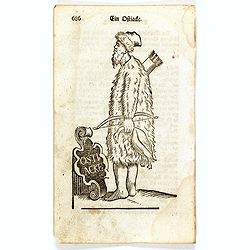
Ein Ostiacke.
Finely executed wood block print taken from the "Neueröffnetes Amphitheatrum Worinnen. . .", which book was issued in five parts between 1722 and 1728, with vo...
Date: Erfurt, ca. 1724
Selling price: ????
Please login to see price!
Sold in 2016
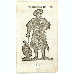
Ein Muscovitischer Herr.
Finely executed wood block print taken from the "Neueröffnetes Amphitheatrum Worinnen. . .", which book was issued in five parts between 1722 and 1728, with vo...
Date: Erfurt, ca. 1724
Selling price: ????
Please login to see price!
Sold in 2016
Ein Samojed.
Finely executed wood block print taken from the "Neueröffnetes Amphitheatrum Worinnen. . .", which book was issued in five parts between 1722 and 1728, with vo...
Date: Erfurt, ca. 1724
Selling price: ????
Please login to see price!
Sold in 2016
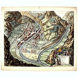
Moustiers.
A beautifully engraved and richly decorated plan of Moustiers. A key (A-Q) in the lower part refers to the principal places of interest in the town.Joan Blaeu published d...
Date: Amsterdam, 1724
Selling price: ????
Please login to see price!
Sold in 2016
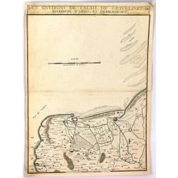
Les Environs de Calais, Gravelines, Bourbourg, d'Ardes, et d'Embleteuse & c.
A map showing the border between France and the Netherlands near Calais, Gravelines, Bourbourg, Ardes, and Embleteuse, by Nicolas de Fer, published in Paris in 1724. It w...
Date: Paris, 1724
Selling price: ????
Please login to see price!
Sold in 2018
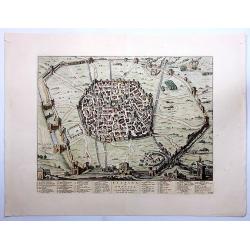
Felsina Sive Bononia Antiqua...
A very detailed copper engraved plan of ancient Bologna, from Johannes Blaeu's scarce series of Italy town books. Published by Pierre Mortier. Willem Janszoon Blaeu (157...
Date: Amsterdam, 1663-1724
Selling price: ????
Please login to see price!
Sold in 2023
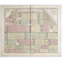
Tafel vande XVII Nederlandze Provincien, Vertonende der zelver verdeling, grootte van Landen en Steden, mids-gaders haar Regering, zo Politicq als Kerk-lyck, en veel andere merkweerdige zaken, ten nutte vande Historien en Geographie.
Interesting engraving, showing description and crests of the 17 Dutch provinces, the major cities and towns, political and religious diversity, trades, inventions and VOC...
Date: Amsterdam, 1724
Selling price: ????
Please login to see price!
Sold in 2019

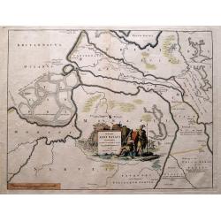
Carte Marine De La Mer Caspiene levée suivant les ordres de S.M.Cz. En 1719, 1720 et 1721.
Detailed of the Caspian Sea, prepared by Karl van Verden in 1722. Van Verden was a Russian sailor and the Czar's Special Commander, who produced the first accurate map of...
Date: Paris, ca. 1725
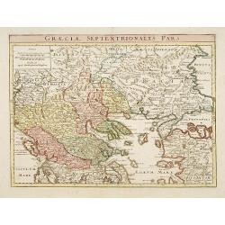
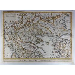
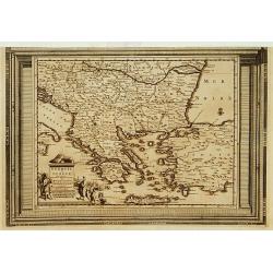
Graeciae Septentrionalis Pars.
A very striking map of northern Greece. From Schul-und-Reisen Atlas..
Date: Nuremberg 1725
Selling price: ????
Please login to see price!
Sold
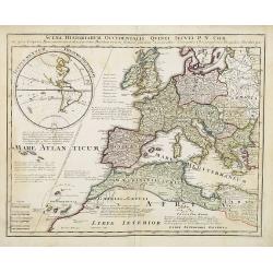
Scena Historiarum Occidentalis Quinti Seculi P.N. CHR.
A very striking map of Europe. Decorated with a hemisphere of North and South America, annotated with various commentaries in Latin.
Date: Nuremberg, ca 1725
Selling price: ????
Please login to see price!
Sold in 2008
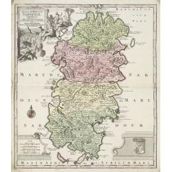
Insula et Regnum Sardiniae . . .
Kingdom of Sardinia. With arms lower right and a cartouche upper left of figures and animals in a landscape.
Date: Paris, ca. 1725
Selling price: ????
Please login to see price!
Sold in 2009
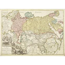
Carte nouvelle de tout l'empire de la grande Russie dans l'estat ou il s'est trouvé à la.mort de Pierre le Grand. . .
Rare map showing the Empire of Peter I the Great at the time of his death in 1723. Lower right a large title cartouche with a portrait of Peter I the Great or Pyotr Alexe...
Date: Amsterdam, ca. 1723-1725
Selling price: ????
Please login to see price!
Sold in 2010
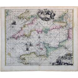
Canalis inter Angliae et Galliae Littera (English Channel)
This map was originally made and published by Frederick de Wit. The plate was acquired by the Ottens brothers after the death of De Wit's son in 1706. Following the gener...
Date: Amsterdam, ca. 1725
Selling price: ????
Please login to see price!
Sold in 2010
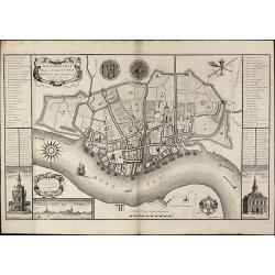
Ichnographia Burgi perantiqui Lennae regis in Agro Norfolciensi accurate delineata Ano MDCCXXV.
Important and very rare plan of King's LynnA large and detailed copper engraved plan of King's Lynn Harbour in Norfolk, drawn and published by Gulielmus Rastrick in 1725....
Date: London, 1725
Selling price: ????
Please login to see price!
Sold in 2010
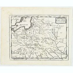
A new map of Poland from the latest Obser.ns
Uncommon map of Poland and Lithuania. In upper right corner "front Page 137". Published in "Patrick Gordon's Geography Anatomiz'd" by John Senex.
Date: London, J. Senex, ca. 1725
Selling price: ????
Please login to see price!
Sold in 2012
Descriptio Agri Batavi Aliorumque qui hodie cis Rhenum in dicione VII Foedereratorum Auctore Mensone Alting.
Unusual map of Zeeland and Flanders with ancient names. With good detail on rivers and islands. Decorated with numerous warriors engaged in battle.
Date: Amsterdam, 1725
Selling price: ????
Please login to see price!
Sold in 2014
Claudii Ptolemaei Tabula Germaniae Magnae
This minimalised map shows Germany as it was described by Ptolemy. The major rivers, mountains, forests and cities are shown but not much else. Very few of the names are ...
Date: Amsterdam, 1725
Selling price: ????
Please login to see price!
Sold in 2019
DELINEATIO SYRACUSARUM ANTIQUARUM QUADRIURBIUM
An exceptional, finely-engraved view of the Sicilian City and Port of Syracuse. Sailing vessels and a decorative cartouche. Rare.
Date: Amsterdam, ca 1725
Selling price: ????
Please login to see price!
Sold in 2016
Le Cercle de Souabe Subdivise en Tous les Etats...
A fine, very large map of Swabenland including Lake Constance, Ulm, Augsburg, Basle, etc. Showing the sources of both the Danube and Rhine Rivers. This plate, after Sanso...
Date: Amsterdam, c1725
Selling price: ????
Please login to see price!
Sold in 2016
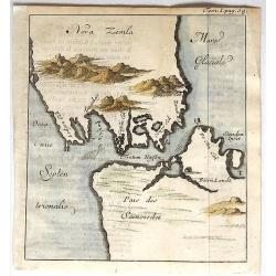
Nova Zemla.
Unusual, detailed, miniature map of Kara Strait and the southern tip of Novaya Zemlya, Russia, and the northern tip of Arctic Russia. The mountains are overstated. The ma...
Date: Paris, 1725
Selling price: ????
Please login to see price!
Sold in 2019
Ducatus Silesiae Iauranus. Aut : Frid : Kühnovio. . .
Rare Pieter Schenk edition of Friedrich Kubn's (Kühnovio) map of Jawor in southwest Poland based on Johann Gottfried Bartsch, map first published in Świdnica (then Schw...
Date: Amsterdam, 1700-1725
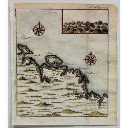
Cola (Untitled).
Uncommon map of part of the Kola peninsula coast, between the White and Barents Seas. It is in the Murmansk region.The town of Kola is shown but it is now eclipsed by the...
Date: Paris, 1725
Selling price: ????
Please login to see price!
Sold in 2017
Graeciae Pars Septentrionalis.
A large and dramatic map by de L'Isle of the northern Greece, the Balkans, and Macedonia. Map extent covers from Dalmatia east to the Black Sea (Pontus Euxinus) and south...
Date: London, 1725
Selling price: ????
Please login to see price!
Sold in 2018
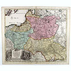
Regni Poloniae, ducatus Lithuaniae Voliniae, Podoliae Ucraniae Prussiae et Curlandiae Descriptio emendata per R. & I. Ottens.
Very rare map of Poland Lithuania and Ukraine, etc. Engraved by A. Schut.Joachim Ottens (1663 - 1719) and his sons Renier and Joshua were prominent Dutch booksellers and ...
Date: Amsterdam, 1725
Selling price: ????
Please login to see price!
Sold in 2017
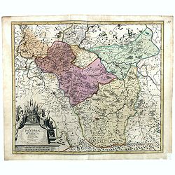
Regni Poloniae, ducatus Mazoviae et province Cujaviae / descriptio emendata per R. & I. Ottens
Very rare map of Poland Lithuania and Ukraine, etc. Engraved by A. Schut.Joachim Ottens (1663 - 1719) and his sons Renier and Joshua were prominent Dutch booksellers and ...
Date: Amsterdam, 1725
Selling price: ????
Please login to see price!
Sold in 2017
Descriptio Agri Batavi Aliorumque qui hodie cis Rhenum in dicione VII Foedereratorum Auctore Mensone Alting.
Unusual map of Zeeland and Flanders with ancient names. With good detail on rivers and islands. Decorated with numerous warriors engaged in battle.prepared by the Menso A...
Date: Amsterdam, 1725
Selling price: ????
Please login to see price!
Sold in 2018
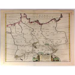
Borussiae Regnum cum adjacentibus Regionibus. . .
Seutter's pocket map of northern Poland, Konigsburg (Kaliningrad) and of Lithuania. Includes the cities of Gdansk (Danzig), Elblag (Elbing), Malbork (Marienburg), Lidzbar...
Date: Augsburg, ca. 1725
Selling price: ????
Please login to see price!
Sold in 2018
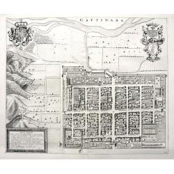
Gattinara.
A superb town plan of Gattinara, a village in the Piedmont region in Italy, between Torino, Vercelli and Lago Maggiore. It is situated near the Sesia river. Published in ...
Date: Amsterdam, 1668-1725
Selling price: ????
Please login to see price!
Sold in 2020
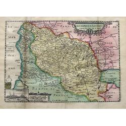
Le comte d'Artois. . .
A detailed map of Artois with an inset view of Arras. Decorated with old hand color, a title cartouche, small coat of arms, compass rose, and distance scale.
Date: Paris, ca 1725
Selling price: ????
Please login to see price!
Sold in 2019
![Comitatus Zelandiae Novissima Delineatio Per... Nun[c] Apud Pet. Schenck Jun.](/uploads/cache/91535-250x250.jpg)
Comitatus Zelandiae Novissima Delineatio Per... Nun[c] Apud Pet. Schenck Jun.
Detailed chart of islands in south west Netherlands with details shown pictorially.
Date: Amsterdam, 1726
Selling price: ????
Please login to see price!
Sold in 2010
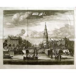
Montalbaans Toren en Waterkeer.
Suberp view of the Montelbaanstoren in Amsterdam. Highly detailed print with buildings, people loading barrels, the watergate, and sailing ships.
Date: Amsterdam, 1726
Selling price: ????
Please login to see price!
Sold in 2012
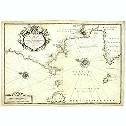
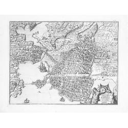
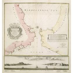
Plan du Golfe de Naples et Des Environs. . .
Fine and rare chart of the Gulf of Naples and neighboring regions, including the Islands of Ischia, Capri and Procida. The chart has a large cartouche, and is adorned wit...
Date: Marseille, 1715-1726
Selling price: ????
Please login to see price!
Sold in 2014
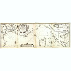
Nouvelle Carte De Cotes De Catalogne, Rousiilon, Languedoc, Provence, D'Italie et Partie De L'Isle De Corce . . .
Striking two-sheet chart of the Mediterranean Coast, from Catalonia to the mouth of the Tiber River in Italy, showing most of Corsica and the island of Elba, with 6 large...
Date: Marseille, 1715-1726
Selling price: ????
Please login to see price!
Sold
Nieuwe Paskaart vant Naauw van de Straat. op gedragen aan den Hoog Edel geboren Heer F. Van Aerssen Van Sommelsduk
This is a scarce and well designed sea chart of the Strait of Gibraltar, oriented east with Spain on the left and the Barbary Coast (present-day Morocco) on the right. Th...
Date: Amsterdam 1726
Selling price: ????
Please login to see price!
Sold in 2023
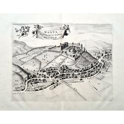
Manta Salutiarum March Oppidum
Beautifully engraved view of Manta in Piemonte. Shows the town with detailed buildings, roads, and fields. The title banner and the coat of arms are held by putti. From ...
Date: Amsterdam, 1726
Selling price: ????
Please login to see price!
Sold in 2023
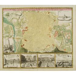
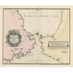
Accurater grundris der .. Spanischen Haupt und Residentz stadt MADRIT ..
This plan of Madrid is richly ornated by various garden scenes, as well below with four views, among them we find the Royal Residence, Aranjuez and the Place Major.
Date: Nuremberg 1727
Selling price: ????
Please login to see price!
Sold

Academia Tertia Anglicana or The Antiquarian Annals of Stanford in Lincoln, Rutland, and Northampton Shires
First Edition of Peck's history of Stanford. Describing University, churches, schools of Stanford and several other places. Folding panorama frontis 'The Prospect of the ...
Date: 1727
Selling price: ????
Please login to see price!
Sold in 2010
Nieuwe Paskaart van t Naauw van de Straat. . . F.van Aerssen van Sommelsdyk, de plaat bommel en Spyk. . . Hendrik Lynslager. . . 1726.
Chart of the entrance of the Mediterranean overlooking the Strait of Gibraltar. Based on the charts by Hendrik Lynslager, a Dutch navigator, this interesting sea chart de...
Date: Amsterdam, ca. 1727
Selling price: ????
Please login to see price!
Sold in 2013
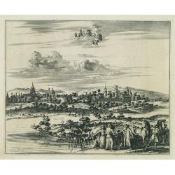
Cassimogorod ville de la Tartarie Moscovite.
Decorative view of the town of Cassimogorod, a Russian city near the northern shore of the Caspian sea as seen from across the river Occa. Finely etched view after a draw...
Date: Leiden, 1727
Selling price: ????
Please login to see price!
Sold in 2010
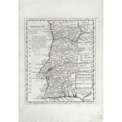
Portugal. Agreeable to Modern History. . .
Detailed, small scale map of Portugal by Herman Moll (fl.1680-1732). Little is known of Herman Moll's early life, but he emigrated from what is now northern Germany and s...
Date: London, 1727
Selling price: ????
Please login to see price!
Sold in 2010
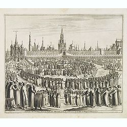
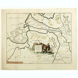
Château Kremelin, dans la ville de Moscou, avec la celebration de la Fete de Pâques Fleuries.
Decorative view of the Kremlin in Moscow, showing the Palm Sunday festivities at the Kremlin. Some buildings with captures: Kremlin, Porte du Sauveur. S. Nicolai. This we...
Date: Leiden, 1719-1727
Selling price: ????
Please login to see price!
Sold in 2013
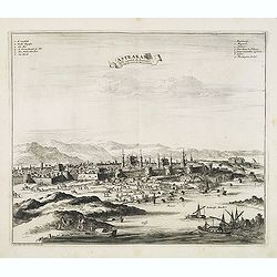
Astrakan, ville capitale du royaume du même nom en Moscovie.
Decorative view of the town of Astrakan. This well executed engraving was published in 1729 and 1727 by Pieter van der AA, in Leiden in "Voyages tres-curieux et tres...
Date: Leiden, 1719-1727
Selling price: ????
Please login to see price!
Sold in 2014
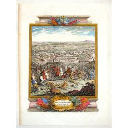
The Battle of Piterwaradin - August the V, 1716.
Antique hand-colored folio copper plate from Jean Dumont's book "The Military History of the Late Prince Eugene of Savoy and the Late John Duke of Marlborough"....
Date: London, 1727
Selling price: ????
Please login to see price!
Sold in 2015
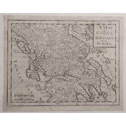
A Map of Epirus, Thessaly and Achaia.
Detailed map of Epirus, Thessaly and Achaia and Peloponnesus in Greece. Cartographer unknown.
Date: ca. 1727
Selling price: ????
Please login to see price!
Sold in 2020
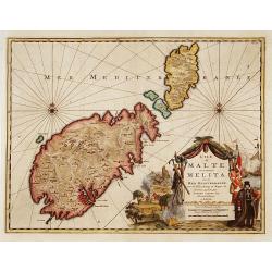
L'ile de Malte, anciennement Melita..
Fine map depicting Malta. Embellished with a very beautiful title cartouche showing an historical scene.From van der Aa's very rare work "La galerie agréable du Mon...
Date: Leiden, c.1728
Selling price: ????
Please login to see price!
Sold
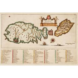
Typus insularum Melitae..
Fine map depicting Malta and to other isles. Embellished with a very beautiful title cartouche, a sailing ship, a sea monster and a compass-rose showing north to the lowe...
Date: Leiden, c.1728
Selling price: ????
Please login to see price!
Sold
Turquie en Europe, suivant les nouvelles observations..
Uncommon edition of this map of Greece and eastern Turkey. With decorative title cartouche lower left corner.This example is unusual in having the additional separately e...
Date: Amsterdam 1728
Selling price: ????
Please login to see price!
Sold
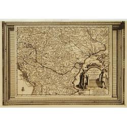
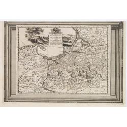
La Hongrie, suivant les nouvelles observations..
Uncommon edition of this map of Eastern Europe with the river Danube. With decorative title cartouche lower right corner.This example is unusual in having the additional ...
Date: Amsterdam 1728
Selling price: ????
Please login to see price!
Sold
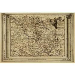
La Prusse, suivant les nouvelles observations..
Scarce edition of this map of Prussia, Poland and Northern Germany. With decorative title cartouche upper part.This example is unusual in having the additional separately...
Date: Amsterdam, 1728
Selling price: ????
Please login to see price!
Sold in 2009
La Bohême, suivant les nouvelles observations..
Uncommon edition of this map of Czech Republic. With decorative title cartouche upper right corner.This example is unusual in having the additional separately engraved de...
Date: Amsterdam 1728
Selling price: ????
Please login to see price!
Sold
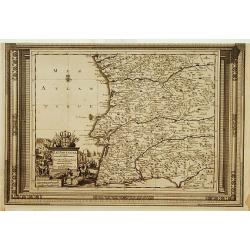
Le Portugal, suivant les nouvelles observations..
Uncommon edition of this map of Portugal. With decorative title cartouche lower left corner.This example is unusual in having the additional separately engraved decorativ...
Date: Leiden, 1728
Selling price: ????
Please login to see price!
Sold in 2014
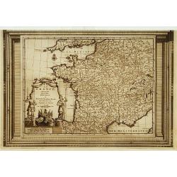
La France, suivant les nouvelles observations..
Uncommon edition of this map of France. With decorative title cartouche lower left corner.This example is unusual in having the additional separately engraved decorative ...
Date: Amsterdam 1728
Selling price: ????
Please login to see price!
Sold