Browse Listings in Europe
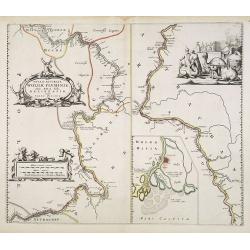
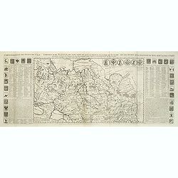
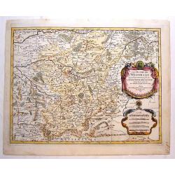
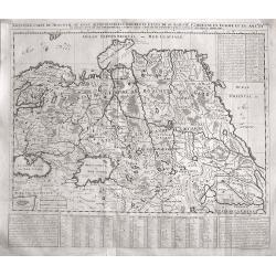
Nova & Accurata Wolgae Fluminis, olim Rha dicti, delineatio Auctore Adamo Oleario..
This is the rare Covens and Mortier's issue of Blaeu's copper plate showing a map of the Volga River in three parts based on the travels of Adam Olearius. The left side o...
Date: Amsterdam, 1720
Selling price: ????
Please login to see price!
Sold in 2010
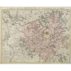
Carte de la prevosté et vicomté de Paris.
Paris and the surrounding territory including major roads.Guillaume de l'Isle (1675-1726) was the son of a cartographer and pupil of Jean Dominique Cassini, who, among ot...
Date: Amsterdam, 1720
Selling price: ????
Please login to see price!
Sold
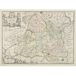
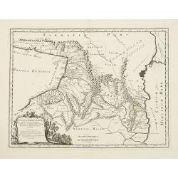
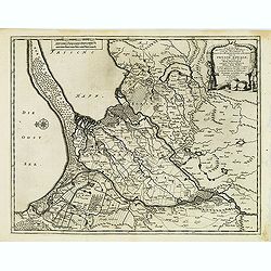
Drentia comitatus transisulaniae tabula II. . .
A map of Drente and part of Overijssel. The surveyor of this map is Cornelus Pynacker who made his survey in 1634, and the map was engraved by A. van den Broeck. This is ...
Date: amsterdam, 1720
Selling price: ????
Please login to see price!
Sold in 2013
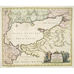
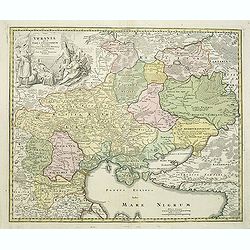
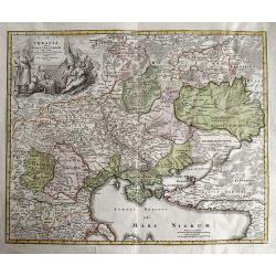
Nouvelle Carte Georaphique De La Mer D'Asof ou de Zabache & Des Palus Meotides . . .
Detailed and decorative map of Sea of Azov, northern Black Sea and Ukraine, including Rostov.The map is very rare and when found it is the first edition, published by Vis...
Date: Amsterdam, ca. 1720
Selling price: ????
Please login to see price!
Sold in 2010
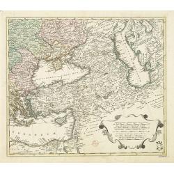
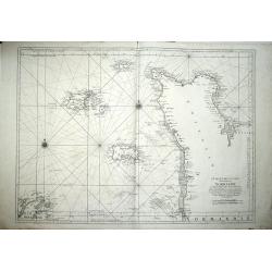
Area between the Black Sea and the Caspian Sea.
Nice and scarce map encompassing part of the Near East and the area comprehended between the Black Sea and the Caspian Sea.Centered on Turkey, with an oversized Cyprus. I...
Date: Nuremberg, ca 1720
Selling price: ????
Please login to see price!
Sold in 2016
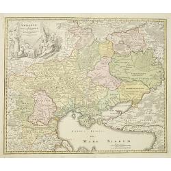
Ukrania quae et Terra Cosaccorum..
Homann's map is based upon Beauplan's general map of Ukraine but depicts the political changes of the preceding years. The cartouche portrays Hetman Mazepa with his follo...
Date: Nuremberg, 1720
Selling price: ????
Please login to see price!
Sold in 2010
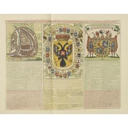
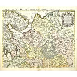
Carte du Gouvernement Civil et Ecclesiastique de Moscovie, l'Etat des Revenus et l'Ordre de la Justice et des Officiers
Very fine engraved text sheet with a small (5.5 x 5.5"), detailed plan of Moscow, plus two large coats-of-arms. Descriptive French text below, size is for the overal...
Date: Amsterdam, ca. 1720
Selling price: ????
Please login to see price!
Sold in 2010
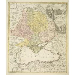
Tabula Geographica qua pars Russiae Magnae. . .
Homann's map is based upon Beauplan's general map of Ukraine but depicts the political changes of the preceding years. With decorative cartouches. Giving good detail alon...
Date: Nuremburg, 1720
Selling price: ????
Please login to see price!
Sold in 2010
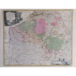
Arena Martis in Belgio qua Provincia x Catholica Inferioris Germania.
Homann map of northern France, Belgium and Holland - shows from Paris, France in the south up to Rotterdam, Holland in the north. Small inset view of Luttich (Liege, Beli...
Date: Nuremberg, 1720
Selling price: ????
Please login to see price!
Sold in 2010
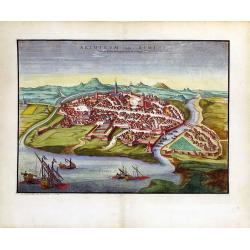
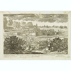
Ariminum Vulgo Rimini.
A splendid view of Rimini, Italy done by Pierre Mortier in the early 18th century.
Date: Amsterdam, ca. 1720
Selling price: ????
Please login to see price!
Sold in 2010
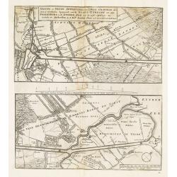
Nieuwe en nette aftekening van de door gravinge die er staat te geschieden beginnende van de stadt Utrecht tot aan Spakenborg in de Zuyder Zee. . .
New and accurate map of the canal from the city of Utrecht to Spakenburg on the Zuider Zee.A map taken from the first truly international speculative crisis in the histor...
Date: Amsterdam, 1720
Selling price: ????
Please login to see price!
Sold
Carte Particuliere d'Anjou et de Touraine, ou de la Partie Meridionale de la Generalite de Tours.
Map of the Anjou region of western France along the Loire River. Include are the cities Tours, Blois and Ancenis (from right to left) along the Loire.left margin: 3/4&quo...
Date: Paris, 1720
Selling price: ????
Please login to see price!
Sold in 2010
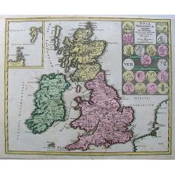
Insulae Britannicae Antiquae ex collatione.
Nice high decorative map with an inset of thule and seems to the Ornkney Isles. There are old coins displayed on the map. On the map are small spots and it has narrrow ma...
Date: Nurnberg, 1720
Selling price: ????
Please login to see price!
Sold in 2013
Vindelicia Rheti.
Nice original colored map with cartouche and coins on it. There are a few pencil lines on it.
Date: Nurnberg, 1720
Selling price: ????
Please login to see price!
Sold in 2010
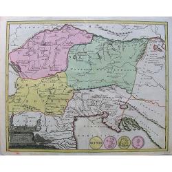
Armenia Utraque.
Nice hand-colored map of Caucuses including Armenia, Georgia, Azerbaijan, Armenia minor, and Australe.A nice cartouche with coins from the countries makes the map attract...
Date: Nurnberg, 1720
Selling price: ????
Please login to see price!
Sold in 2010
Asia intra Maeotim Pontum et mare Caspium.
Map with handcoloring, a nice cartouche.
Date: Nurnberg, 1720
Selling price: ????
Please login to see price!
Sold in 2010
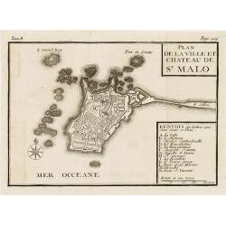
Plan de la ville et château de St Malo
Town-plan of St. Malo with the castle. With a lettered key A-N in lower right corner. In top, Tome 8, Page 414.
Date: France, c. 1720
Selling price: ????
Please login to see price!
Sold in 2010
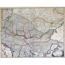
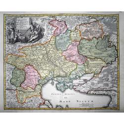
Nova et Accurata Tabula Regnorium Sup. Et Inf. Hungariae It: Sclavoniae, Bosniae, Serviae, Albaniae, Bessarable, ut et Princip. Transylvaniae, Moldavie, Walachiae, Bulgar et Romanie ...
Finely detailed map of Southeastern Europe showing the countries of Hungary, part of Ukraine, Romania, Bulgaria, northern Greece, Albania, Bosnia, Serbia, Croatia and the...
Date: Augsburg, c. 1720
Selling price: ????
Please login to see price!
Sold in 2010
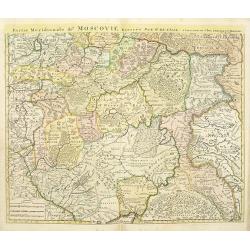
Partie méridionale de Moscovie.
Centered on Moscow including Azow in the bottom part of the map.The Amsterdam publishing firm of Covens and Mortier (1721 - c. 1862) was the successor to the extensive pu...
Date: Amsterdam, ca. 1720
Selling price: ????
Please login to see price!
Sold in 2012
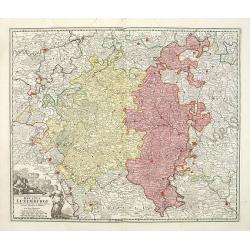
Ducatus Luxemburgi . . .
Fine map of Luxembourg by J. B. Homann. With one decorative cartouche in lower left corner.
Date: Nuremberg, ca. 1720
Selling price: ????
Please login to see price!
Sold in 2011
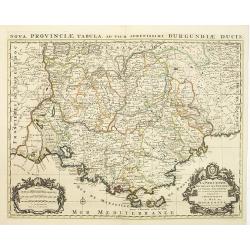
La Provence divisée en ses vigueries et terres adjacentes. . .
Detailed map of southern France. Showing the cities of Marseille, St.Tropez, Cannes, Nice, Antibes, Aix, Orange, Barcelonette, Senez., and Monaco, etc.Prepared by one of ...
Date: Amsterdam, ca 1720
Selling price: ????
Please login to see price!
Sold in 2010
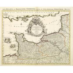
Le Duché et Gouvernement de Normandie divisée en Haute et Basse Normandie.
An attractive large-scale map depicting Normandy. Embellished with a large title-cartouche. Prepared by one of the greatest French mapmakers Hubert Jaillot, and republish...
Date: Amsterdam, ca. 1720
Selling price: ????
Please login to see price!
Sold in 2010
Magni Ducatus Lithuaniae.
An attractive large-scale map depicting Lithuania, embellished with a large title-cartouche with coat of arms. Published in Amsterdam by Renier and Joshua Ottens. Joachim...
Date: Amsterdam, ca. 1720
Selling price: ????
Please login to see price!
Sold in 2010
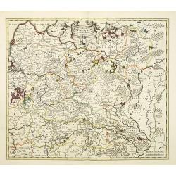
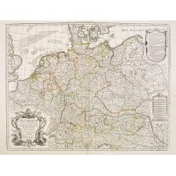
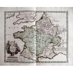
L\'empire d\'Allemagne divisé en tous ses états.
An attractive large-scale map depicting Germany, Poland, the Netherlands, Belgium, Luxemburg, Switzerland and Austria, embellished with a large title-cartouche with coat ...
Date: Amsterdam, ca. 1720
Selling price: ????
Please login to see price!
Sold in 2011
Carte de Moscovie dressée par G.De L\'Isle.
Centered on Moscow, including Lapland. With fine uncolored title cartouche.The Amsterdam publishing firm of Covens and Mortier (1721 – c. 1862) was the successor to the...
Date: Amsterdam, 1720
Selling price: ????
Please login to see price!
Sold in 2012
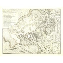
Plan van de Slag gelevert tuschen het Leger van zyne Keyz. . . pris Eugenius van Savoyen. . tusschen Petervaradin en Carlowitz. . .
Uncommon engraving showing the Battle of Petrovaradin or Battle of Peterwardein, which was a decisive victory for Austrian forces in the war between Austria and the Ottom...
Date: Amsterdam, ca. 1720
Selling price: ????
Please login to see price!
Sold in 2011
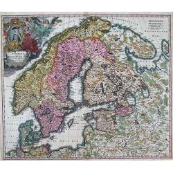
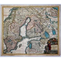
SCANDINAVIA complectens SUECIAE, DANIAE, & NORVEGIAE, REGNA. ex Tabula Joh. Baptista Homann.
A large, detailed map showing all of Scandinavia, including the Baltic region and parts of Russia. An attractive title cartouche decorates the upper left corner of the ma...
Date: Nurnberg, c.1720
Selling price: ????
Please login to see price!
Sold in 2013
Ukrania quae et Terra Cosaccorum..
Homann's map is based upon Beauplan's general map of Ukraine but depicts the political changes of the preceding years. The cartouche portrays Hetman Mazepa with his follo...
Date: Nuremberg, 1720
Selling price: ????
Please login to see price!
Sold in 2011
Comte de gouvernement général de Provence divisé en ses sénéchaussees et vigurie. . .
Map of Provence prepared by Frederik de Wit. The copper plate was acquired by Pierre Mortier. The Amsterdam publishing firm of Covens and Mortier (1721 - c. 1862) was the...
Date: Amsterdam, 1720
Selling price: ????
Please login to see price!
Sold in 2014
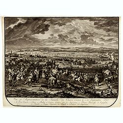
Vue et représentation de la bataille de Hochstedt donnée le 13 d\'aoust 1704. . .
Extremely fine and detailed engraving by Huchtenburg depicting the siege of Hochstedt (Germany) by Price Eugene on August 13th 1704.From Jean Dumont's, "Batailles ga...
Date: The Hague, Pierre Husson, 1720
Selling price: ????
Please login to see price!
Sold in 2011
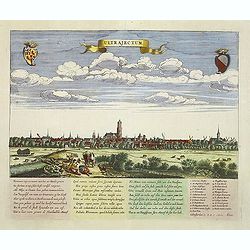
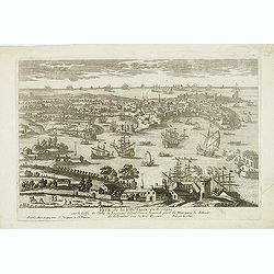
Ultrajectum (Utrecht)
A rare panoramic of Utrecht first published by Dancker Danckerts, here with a changed address. With a numbered key (1-23) to principal places in town and a poem in Latin...
Date: Amsterdam, (1660) c.1720
Selling price: ????
Please login to see price!
Sold in 2013
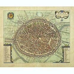
Bruge een der voornaamste steden van Vlaandren.
Detailed plan of Bruges from Flandria Illustrata . In lower right corner "Tom. II. No.37." and title now in Dutch and French, but not with the imprint of Covens...
Date: Amsterdam, 1720
Selling price: ????
Please login to see price!
Sold in 2011
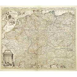
L'Allemagne dressee sur les observations de Tycho-Brahe de Kepler de Selnius. . .
Engraved map in outline color by one of France most important mapmakers. Covers the Low Countries, Germany, Switzerland, Austria, Slovenia, Bohemia and western Poland and...
Date: Paris, c. 1720
Selling price: ????
Please login to see price!
Sold in 2016
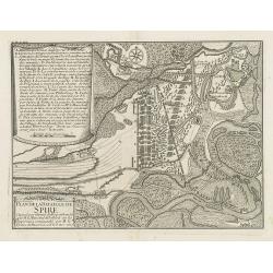
Plan de la bataille de Spire Gagnée par l'armée du Roy comandée par M. le Marechal de Tallard. . .
Showing the siege of Spire on 15 November 1703. With a lettered key A - T in upper left corner.
Date: Paris, c.1720
Selling price: ????
Please login to see price!
Sold in 2016
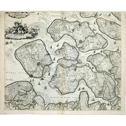
Comitatus Zelandiae tabula..
Fine map covering Zeeland, here in a re-issue by Covens and Mortier. Fine title cartouche and extensive shipping on Westerschelde and other waterways. Shows five islands:...
Date: Amsterdam, c.1720
Selling price: ????
Please login to see price!
Sold in 2014
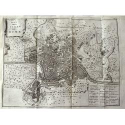
Plan de la Ville de Rome.
Unusual bird's-eye plan of Rome, by Peter van der Aa, probably after De Fer. A detailed view of the city, its expansive walls and the surrounding fields. Shows streets a...
Date: Leiden, 1720
Selling price: ????
Please login to see price!
Sold in 2011
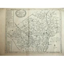
Hartfordshire.
This is an attractive and rare map of Hertfordshire.Copper engraving. Very attractive, uncommon map in good condition . Robert Morden's miniature maps are among the earli...
Date: London, 1720
Selling price: ????
Please login to see price!
Sold
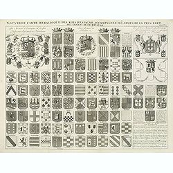
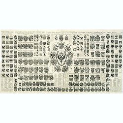
Nouvelle carte héraldique des rois d'Espagne accompagnée des armes . . .
Decorative sheet with coats of arms of Spanish and Portuguese Kings and noble families. This impressive engraving is a wonderful example of Chatelain’s elegant plates f...
Date: Amsterdam, ca. 1720
Selling price: ????
Please login to see price!
Sold in 2012
Germania antiqua. / Carte de l'ancienne Germanie . . .
This impressive engraving is a wonderful example of Chatelain’s elegant plates from his "Atlas Historique, Ou Nouvelle Introduction A L’Histoire …", Tom 2...
Date: Amsterdam, ca. 1720
Selling price: ????
Please login to see price!
Sold in 2012
Carte de etats de la dependance de sa maieste imperiale et des anciens comtes d'Habsbourg.
This impressive engraving is a wonderful example of Chatelain’s elegant plates from his "Atlas Historique, Ou Nouvelle Introduction A L’Histoire …" Showin...
Date: Amsterdam, ca. 1720
Selling price: ????
Please login to see price!
Sold in 2012
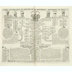
Carte genealogique de Pologne et les princiales. . .
A genealogical tree of the Polish rules from 9th - 17th century. This impressive engraving is a wonderful example of Chatelain’s elegant plates from his "Atlas His...
Date: Amsterdam, ca. 1720
Selling price: ????
Please login to see price!
Sold in 2012
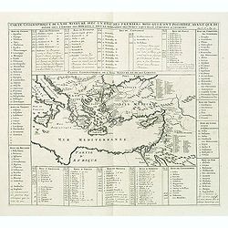
Carte geographique de l'Asie mineure avec un etat des premiers rois. . .
Map of the Mediterranean. This impressive engraving is a wonderful example of Chatelain’s elegant plates from his "Atlas Historique, Ou Nouvelle Introduction A L�...
Date: Amsterdam, ca. 1720
Selling price: ????
Please login to see price!
Sold in 2012
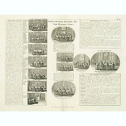
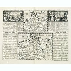
Gouvernement des etats des sept provinces Unies. . .
Print showing the infrastructure of the Dutch government, including the government of the separate provinces and the government of the state. The plate is adorned with a ...
Date: Amsterdam, ca. 1720
Selling price: ????
Please login to see price!
Sold in 2012
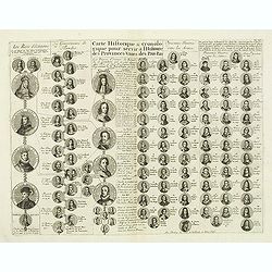
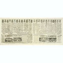
Carte historique & chronologique pour servir à l'histoire des Provinces-Unies des Pais-Bas. . .
Showing the genealogy of the ruling families of Europe who were allied with Holland at the beginning of the eighteenth century. Highly decorative, this impressive genealo...
Date: Amsterdam, ca. 1720
Selling price: ????
Please login to see price!
Sold in 2012
Parte Alpestre dello Stato di Milano, con il Lago Maggiore di Lugano, e di Como.
Highly detailed copper engraved map of the Lago Maggiore, Lago di Lugano, and Lago di Como area. Includes the cities of Bergamo, Milano, Como, Arona, Bellinzona, Locarno,...
Date: Amsterdam, c1720
Selling price: ????
Please login to see price!
Sold
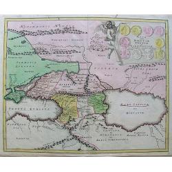
Colchis, Iberia, Albania..
Uncommon map covering the area in-between the Caspian Sea and the Black Sea. With decorative cartouche lower left.
Date: Amsterdam, 1720
Selling price: ????
Please login to see price!
Sold in 2012
Veue de la Ville de Cadix en Espagne. . .
A very RARE panoramic of the city of Cadiz.Engraved by Pierre Aveline (Paris, c.1656 - 23 May 1722). He was also a print-publisher and print-seller. He probably trained ...
Date: Paris, 1690-1720
Selling price: ????
Please login to see price!
Sold in 2012
Rozes, Ville de Catalogne par l'Armée du Roy Louis le Grand sur les Espagnols.
A very RARE panoramic of the city of Rozes.Engraved by Pierre Aveline (Paris, c.1656 - 23 May 1722). He was also a print-publisher and print-seller. He probably trained ...
Date: Paris, 1690-1720
Selling price: ????
Please login to see price!
Sold
Les trois isles appellées. . . Dantzic Marienbourg et Elbing dans la Prusse Royale. . .
Fine and uncommon map including the town of Danzig and the region south of it. East to the top.From van der Aa's very rare work La galerie agréable du Monde. Very attrac...
Date: Leiden, 1720
Selling price: ????
Please login to see price!
Sold in 2015
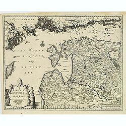
La Lavonie Avec les frontieres de Courlande et de Finlande . . .
Fine and uncommon map showing already quite accurate Livonia, Eastland and Curland. Many villages and towns are named.In the upper part the coast line of Finland.From van...
Date: Leiden, 1720
Selling price: ????
Please login to see price!
Sold in 2012
Carte Heraldique representant les armes de l'emperereur. . .du Saint Empire Romain.
This impressive engraving of heraldic arms of the Holy Roman Empire is a wonderful example of Chatelain’s elegant plates from his "Atlas Historique, Ou Nouvelle In...
Date: Amsterdam, ca. 1720
Selling price: ????
Please login to see price!
Sold in 2012
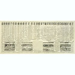
Carte généalogique des branches naturelles ou du coté gauche de la maison des Bourbons. . .
Interesting sheet with an impressive engraving ornamented with numerous vignettes representing French castles of Meudon, Versailles, St. Germain en Laye and Fontaine Blea...
Date: Amsterdam, ca. 1720
Selling price: ????
Please login to see price!
Sold in 2012
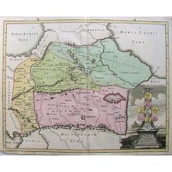
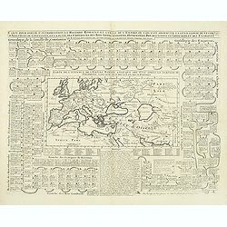
Carte générale des états du Czar Empereur de Moscovie ou l'on voit . . .
General map of Russia of the states of the Czar Emperor of Muscovy showing his possessions in Europe and Asia. To the left and right explanatory panels with coats of arms...
Date: Amsterdam, ca. 1720
Selling price: ????
Please login to see price!
Sold in 2012
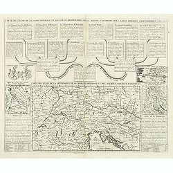
Carte pour servir d'introduction à l'histoire romaine . . .
Map of the ancient Roman Empire. This impressive engraving is a wonderful example of Chatelain’s elegant plates from his "Atlas Historique, Ou Nouvelle Introductio...
Date: Amsterdam, ca. 1720
Selling price: ????
Please login to see price!
Sold in 2012
Nouvelle carte généalogique des branches du coté gauche de la maison de valois . . .
This impressive engraving is a wonderful example of Chatelain’s elegant plates from his "Atlas Historique, Ou Nouvelle Introduction A L’Histoire …", Tom 7...
Date: Amsterdam, ca. 1720
Selling price: ????
Please login to see price!
Sold in 2012
Ukrania quae et Terra Cosaccorum cum vicinis Walachiae, Moldaviae, Minorisq., Tartariae Provinciis exhibita.
Very decorative copper engraved map of the Ukraine with the Black Sea, Sea of Azov, and Crimea. Extending from Moscow to Konstantinopel (Istanbul). Highly detailed with a...
Date: Nuremberg, 1720
Selling price: ????
Please login to see price!
Sold in 2012
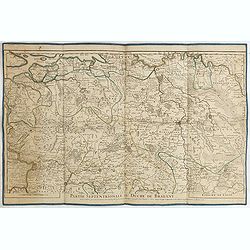
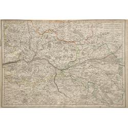
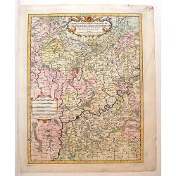
Partie septentrionale du duche de Brabant. . .
Detailed map prepared by Alex-Hubert Jaillot of the Dutch province of Brabant with the towns of 's-Hertogenbosch, Eindhoven, Helmond, Tilburg, Breda, etc. Also including ...
Date: Paris, 1720
Selling price: ????
Please login to see price!
Sold in 2015
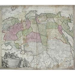
Generalis Totius Imperii Russorum Novissima Tabula.
Highly detailed map of Imperial Russia, at the beginning of the period when Russia was exploring the Pacific Ocean and Arctic Seas. Depicts Russian Empire and northern Ch...
Date: Nuremberg, 1720
Selling price: ????
Please login to see price!
Sold in 2013
Ukrania quae et Terra Cosaccorum cum vicinis Walachiae, Moldaviae, Minorisq., Tartariae Provinciis exhibita.
Rare and very decorative copper engraved map of the Ukraine with the Black Sea.
Date: Nuremberg, 1720
Selling price: ????
Please login to see price!
Sold in 2013
GALLIA VETUS EX IULII CAESARIS...
Interesting map of ancient France. Includes Switzerland and Benelux. With a decorative title cartouche and contemporary hand coloring.
Date: Nuremberg, c1720
Selling price: ????
Please login to see price!
Sold in 2013
The Dutch Netherlands or the seven United Provinces. . .
Fine map of The Netherlands with decorative title cartouche. Engraved by S.Parker. Revised by John Senex.John Senex's A New General Atlas of the World was, strangely the ...
Date: London, 1720
Selling price: ????
Please login to see price!
Sold in 2013
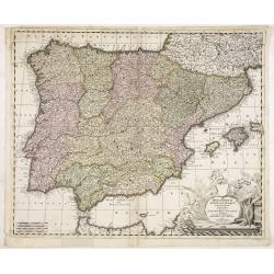
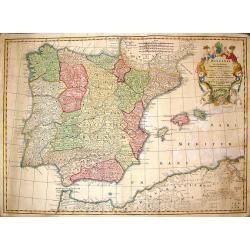
Hispaniarum Portugalliae que coronarum..
Detailed map of Spain and Portugal with large uncolored title cartouche.
Date: Amsterdam, 1720
Selling price: ????
Please login to see price!
Sold in 2025
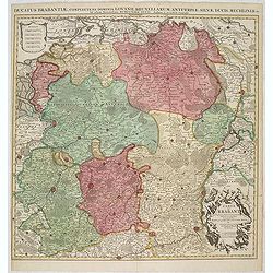
Ducatus Brabantiae, complrctens dominia Lovanii, Bruxellarum, Antverpia. . . / Carte du Brabant. . .
Covens & Mortier's map of Brabant, based upon De L'Isle's map of 1700. The North is orientated to the top side of the map. On the lower right a cartouche decorated wi...
Date: Amsterdam, 1720
Selling price: ????
Please login to see price!
Sold in 2013
Partie Occidentale du Temporel de L'Archevesche et Eslectorat de Treves
Detailed map of Germany and part of Luxemburg. Figurative title cartouche with two putti as well as a ribboned scale cartouche. Nicolas Sanson (1600–1667) was a French...
Date: Paris, 1696 - 1720
Selling price: ????
Please login to see price!
Sold in 2013
Le Duche de Westphalie.
An Interesting map featuring the Duchy of Westfalen. With two, large, super decorative cartouches with two putti and an exraordinary compass rose. Nicolas Sanson (1600–...
Date: Paris, 1696 - 1720
Selling price: ????
Please login to see price!
Sold in 2015
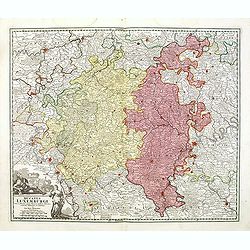
Ducatus Luxemburgi tam in Maiores quam Minores . . .
Fine map of Luxembourg by J. B. Homann. With one decorative cartouche in lower left corner.
Date: Nuremberg, ca. 1720
Selling price: ????
Please login to see price!
Sold in 2014
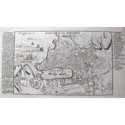
Marseille oder Marsilien.
Very detailed German plan of Marseille and environs, with the harbor and fortifications. With extensive information to the left, and a 26 letter key locating important bu...
Date: Augsburg, c1720
Selling price: ????
Please login to see price!
Sold in 2013
Regni Sueciae in Omnes Suas Subjacentes.
Large, detailed, hand-colored map featuring Sweden, Finland, Eastern Russia and Northern Poland, Lithuania, Latvia & Estonia. Fine allegorical title cartouche with fo...
Date: Nuremberg, 1720
Selling price: ????
Please login to see price!
Sold in 2017
Hispania ex Archetypo Roderici Mendez Sylvae.
Striking copperplate map of Spain & Portugal. Decorative allegorical cartouche with an older man's head and two white horses. The Lotter family were engravers and pub...
Date: Augsburg, 1720
Selling price: ????
Please login to see price!
Sold in 2014
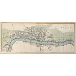
Plan of London in the reign of Queen Elizabeth.
Plan of London in the reign of Queen Elizabeth 1st 1546. This delicately hand colored early map of London is highly detailed. This map dated 1720 by James Stratford of Ho...
Date: London, 1720
Selling price: ????
Please login to see price!
Sold in 2014
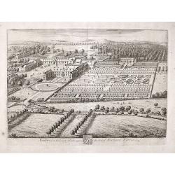
Southwick in the County of Southampton Seat of Richard Norton Esq.
Engraved by Joannes Kip after the drawing by Leonard Knyff. Plate 74 from "Britannia Illustrata or Views of Several of the Queens Palaces and also of the Principal S...
Date: London, 1720
Selling price: ????
Please login to see price!
Sold in 2017
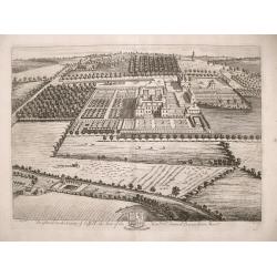
Brightwel in the County of Suffolk the seat of the Honourable Sir Barnardiston Barr.
Brightwel in the County of Suffolk the seat of the Honourable Sir Barnardiston Barr. Plate 52 from "Britannia Illustrata or Views of Several of the Queens Palaces...
Date: London, 1720
Selling price: ????
Please login to see price!
Sold in 2017
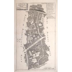
A MAPP OF LIME STREET WARD. TAKEN FROM YE LAST SURVEYS & CORRECTED.
An eighteenth-century plan of Lime Street Ward in the heart of the City of London. The area covered extends north from Fenchurch Street across Leadenhall Street and via S...
Date: London, 1720
Selling price: ????
Please login to see price!
Sold in 2014
![[. . .] rte Ancienne et Moderne des Differents Etats et Pais situez au Long du Danube, pour servir a L'Intelligence De L'His [. . .]](/uploads/cache/34428-250x250.jpg)
[. . .] rte Ancienne et Moderne des Differents Etats et Pais situez au Long du Danube, pour servir a L'Intelligence De L'His [. . .]
A striking and highly detailed copper engraved plate with a map of region north of the Adriatic Sea and centered on the Danube River, from Croatia to the Black Sea. Inclu...
Date: Amsterdam, 1720
Selling price: ????
Please login to see price!
Sold in 2014
![[. . .] ur servir d'introduction à l'histoire Romaine et à celle de l'Empire, ou l'on fait observer la genealogie de cr [. . .]](/uploads/cache/34429-250x250.jpg)
[. . .] ur servir d'introduction à l'histoire Romaine et à celle de l'Empire, ou l'on fait observer la genealogie de cr [. . .]
A striking and highly detailed copper engraved plate with a map of the ancient Roman Empire, including Europe as far east as the Black Sea. Including descriptive text pan...
Date: Amsterdam, 1720
Selling price: ????
Please login to see price!
Sold in 2014
Nouvelle Carte De Moscovie Ou Sont Representes Les Differents Etats De Se Maiesete Czarienne En Europe Et En Asie...
Very detailed, large map of Russia, which, importantly, extends from the Black Sea and from the Balkans to China and the Mer De Tartarie, and hence includes a large part ...
Date: Amsterdam, 1720
Selling price: ????
Please login to see price!
Sold in 2015
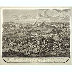
Vue et représentation de la Bataille de Chiari donnée le 1 septebre 1703. . .
Extremely fine and detailed engraving by Huchtenburg depicting the siege of Chiari (Italy) by Price Eugene on September 1st 1703.From Jean Dumont's, "Batailles gagn�...
Date: The Hague, Pierre Husson, 1720
Selling price: ????
Please login to see price!
Sold in 2014
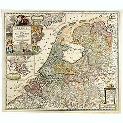
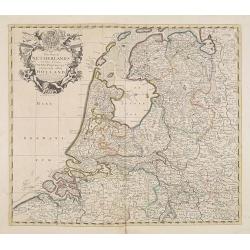
Belgii pars Septentrionalis vulgo Hollandia. . .
A large, decorative colored title cartouche at top left. In an inset -122x140mm- under the title cartouche a small map of Southeast Asia with a panoramic view of the port...
Date: Nuremberg, 1720
Selling price: ????
Please login to see price!
Sold in 2014
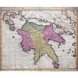
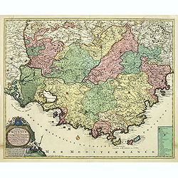
Regnum Moreae accuratissime divisum in Provincias Saccaniam, Tzaconiam, Caliscopium et Ducatum Clarensae, una cum Insulis Cephalonia, Zacyntho, Cythera, Aegina et Sidra
Uncommon map of Greece, by Gerardus Valk and Leonardus Valk in old colors.
Date: Amsterdam, circa 1720
Selling price: ????
Please login to see price!
Sold in 2017
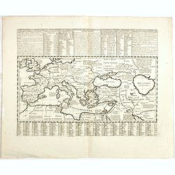
Carte historique chronologique et géographique de l'empire romain où l'on fait observer son étendue et diverses remarques pour l'intelligence de l'histoire.
Interesting sheet with a map of the Roman Empire, with descriptive French text, from Chatelain's monumental 7-volume "Atlas Historique". In upper right margin: ...
Date: Amsterdam, 1720
Selling price: ????
Please login to see price!
Sold in 2017