Browse Listings in Europe
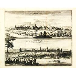
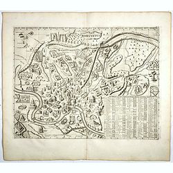
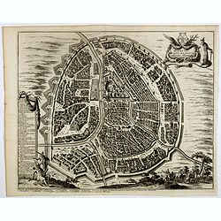
Soratof / Tzornogor.
Pieter van der Aa was a prolific publisher. He published a.o. ' Naauwkeurge versameling der gedenkwaardigste zee- en land-reysen', a series of accounts of voyages (1706-0...
Date: Leiden, 1719
Selling price: ????
Please login to see price!
Sold
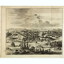
La Fortresse de Noteburg.
Pieter van der Aa was a prolific publisher. He published a.o. ' Naauwkeurge versameling der gedenkwaardigste zee- en land-reysen', a series of accounts of voyages (1706-0...
Date: Leiden, 1719
Selling price: ????
Please login to see price!
Sold in 2010
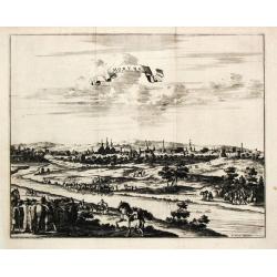
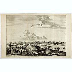
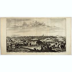
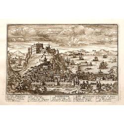
Moruma.
Pieter van der Aa was a prolific publisher. He published a.o. ' Naauwkeurge versameling der gedenkwaardigste zee- en land-reysen', a series of accounts of voyages (1706-0...
Date: Leiden, 1719
Selling price: ????
Please login to see price!
Sold
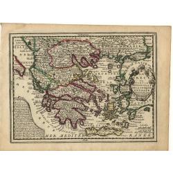
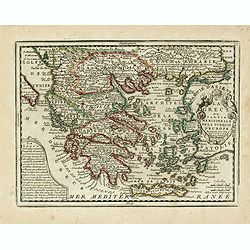
La Grece..
Nice small map of Greece, with decorative cartouches.
Date: Paris, 1719
Selling price: ????
Please login to see price!
Sold
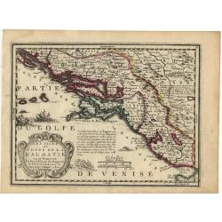
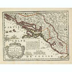
Les Isles et coste de la Dalmatie.
Nice small map of the Balkan coast.
Date: Paris, 1719
Selling price: ????
Please login to see price!
Sold
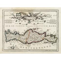
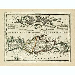
Isle et Royaume de Candie.
Uncommon small map of Crete displaying precise engraving and a flourishing, banner-style cartouche.From Le Nouveau et Curieux Atlas Geographique et Historique.. by Jacque...
Date: Paris, 1719
Selling price: ????
Please login to see price!
Sold in 2012
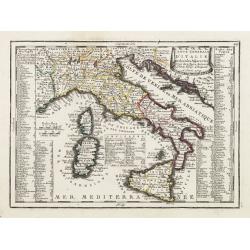
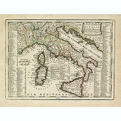
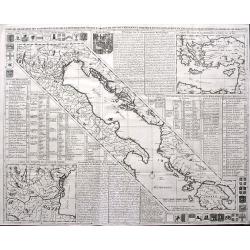
Carte Generale D'Italie Et des Isles Adjacentes..
Decorative map of Italy displaying at both sides a list containing the names of the popes. In the Tyrrhenian Sea instead, a table presents a list of the Antipopes.From Le...
Date: Paris, 1719
Selling price: ????
Please login to see price!
Sold in 2022
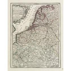
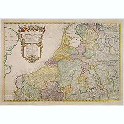
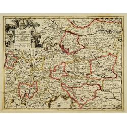
Les XVII Provinces Des Pays Bas..
Decorative map of the Low Countries, extending southwards as far as the North-East of France.From Le Nouveau et Curieux Atlas Geographique et Historique.. by Jacques Chiq...
Date: Paris 1719
Selling price: ????
Please login to see price!
Sold
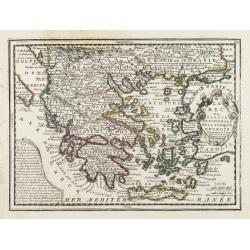
La Grece ou Partie Meridionale de la Turquie d'Europe..
Decorative map of Greece displaying precise engraving and a title cartouche flanked by 2 winged female figures, surmounted by a fan shaped shell.Another cartouche contain...
Date: Paris, 1719
Selling price: ????
Please login to see price!
Sold in 2022
Les Isles et Coste de la Dalmatie ou se Trouvent la Republique de Raguse..
Fine map of the Dalmatian coast with a decorative title cartouche.Presents vessels in the Adriatic Sea and some text containing information about the Republic of Ragusa, ...
Date: Paris, 1719
Selling price: ????
Please login to see price!
Sold in 2010
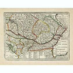
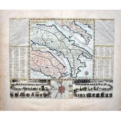
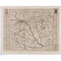
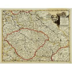
Le Royaume de Hongrie ou se trouvent La Transilvanie, La Moldavie, La Valaquie, L\'esclavonie, La Bosnie, La Servie, et la Bulgarie..
Map of Hungary including most part of southeastern Europe as far as Istanbul.It shows a text table at the bottom containing the names of Hungarian rulers.From Le Nouveau ...
Date: Paris, 1719
Selling price: ????
Please login to see price!
Sold in 2009
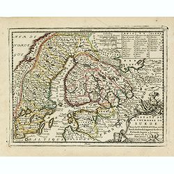
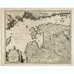
Estats de la Couronne de Suede dans la Scandinavie, ou sont Suede, Gotlande, Lapponie Suedoise, Finlande, Ingrie et Livonie. Subdivisees en leurs Provinces..
Lovely small map centered on Finland, with Sweden and much of Norway to the west, Frontieres de Moscovie to the east.Depiction of lakes, rivers and coastline reminiscent ...
Date: Paris, 1719
Selling price: ????
Please login to see price!
Sold in 2009
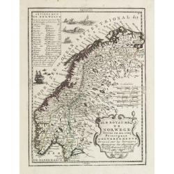
Le Royaume de Norwege Divisé en ses cinq Principaux Gouvernements..
Lovely small map of Norway, with much of Sweden to the East, vessel and sea monsters in the Norwegian Sea.It shows a text table in the upper left corner containing the na...
Date: Paris, 1719
Selling price: ????
Please login to see price!
Sold in 2017
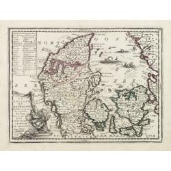
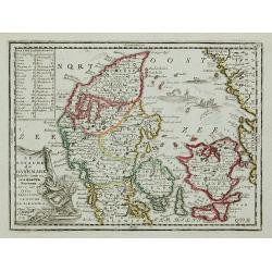
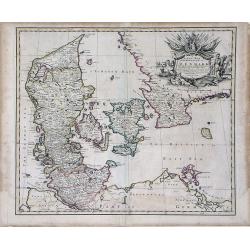
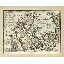
Le Royaume de Danemark Subdivisée en ses quatre Dioceses..
Lovely small map of Denmark, with decorative title cartouche.It shows a text table in the upper left corner containing the names of local rulers.From Le Nouveau et Curieu...
Date: Paris 1719
Selling price: ????
Please login to see price!
Sold
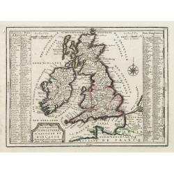
Les Royaumes D'Angleterre, D'Escosse Et D'Irlande..
Lovely small map of the British Isles with two side panels listing Scottish and English kings.From Le Nouveau et Curieux Atlas Geographique et Historique.. by Jacques Chi...
Date: Paris 1719
Selling price: ????
Please login to see price!
Sold in 2008
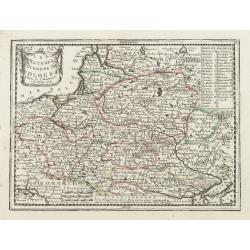
Les Estats de la Couronne de Pologne.
Lovely small map of Poland with title cartouche and a panel in the upper right corner listing local rulers.From Le Nouveau et Curieux Atlas Geographique et Historique.. b...
Date: Paris, 1719
Selling price: ????
Please login to see price!
Sold in 2008
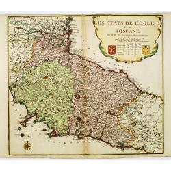
Les etats de L'eglise et de Toscane..
Rare map of Tuscany and the island of Elbe... Prepared by Nicolas de Fer.
Date: Paris, 1719
Selling price: ????
Please login to see price!
Sold
Le Royaume de Danemark Subdivisée en ses quatre Dioceses ...
Lovely small map of Denmark, with decorative title cartouche.It shows a text table in the upper left corner containing the names of local rulers.From Le Nouveau et Curieu...
Date: Paris, 1719
Selling price: ????
Please login to see price!
Sold in 2011
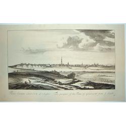
Facies Civitalis GLASCOAE...The prospect of the Town of Glasgow from the South
A beautifully engraved view of Glasgow, Scotland from a southern approach. Glasgow is dominated in the center by its cathedral. From the THEATRUM SCOTIAE, an important re...
Date: ca. 1719
Selling price: ????
Please login to see price!
Sold in 2011
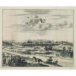
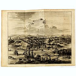
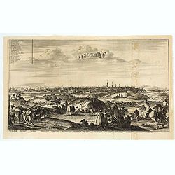
Moruma ville de la Tartarie Moscovite.
Decorative view of the town of Moruma, Russian city near the northern shore of the Caspian sea as seen from across the river Occa. Finely etched view after a drawing by N...
Date: Leiden, 1719
Selling price: ????
Please login to see price!
Sold in 2010
A New Map of the Kingdom of Denmark with the Dutchy of Holstein & c. According to the Newest Observations. . .
A finely detailed map of Denmark with lower Sweden by John Senex. Shows the rivers, marshes, lakes, cities, villages and mountains of the region. A beautiful, illustrated...
Date: London, 1719
Selling price: ????
Please login to see price!
Sold in 2010
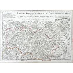
Carte des Provinces du Maine et du Perche dans Laquelle se trouve comprise La Partie Septentrionale De La Generalite De Tours
Finely detailed map of the province of Maine in northwestern France by Guillaume de L'Isle. Cities, villages, rivers, forests and mountains of the regions are depicted. T...
Date: Paris, 1719
Selling price: ????
Please login to see price!
Sold in 2010
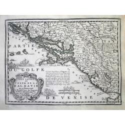
Les Isles et Coste de la Dalmatie. . .
An interesting map of the Dalmatian coast with the Republique of Raguse (Dubrovnik) at the centre. Based on Sanson's map from 1665. The area shown extends from Zadar in C...
Date: Paris, 1719
Selling price: ????
Please login to see price!
Sold in 2014
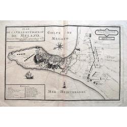
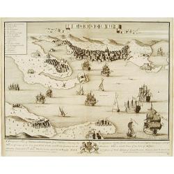
Plan de la Ville et Chateau de Melazo,...
Very rare map of the city and bay of Milazzo in Sicily. Shows the town during the attacks through the Spanish during 1718 and 1719. Illustrates the town and fortification...
Date: Paris, 1719
Selling price: ????
Please login to see price!
Sold in 2016
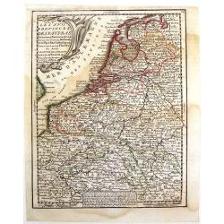
A new map of the Flanders and Holland. . .
Uncommon and large attractive map of The Low Countries. According to the title cartouche the map was printed by Charles Inselin in Paris. The cartouche with the address o...
Date: London or Paris,? c.1707-1719
Selling price: ????
Please login to see price!
Sold in 2015
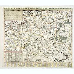
Nouvelle carte du royaume de Pologne, divisée selon. . .
Chatelain's map of Poland. The title is in two lines across the map. On bottom border appears an index to the map's contents. At the top of the map appear historical rema...
Date: Amsterdam, 1719
Selling price: ????
Please login to see price!
Sold in 2015
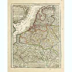
Les XVII Provinces des Pays Bas.
A pleasant little map of the Netherlands. It features the twelve provinces and has an insert explaining the "Rebellion d'Hollande." JACQUES CHIQUET (1673-1721) ...
Date: Paris, 1719
Selling price: ????
Please login to see price!
Sold in 2016
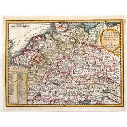
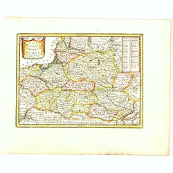
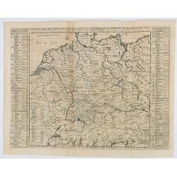
L'Empire d'Allemagne Divise en ses Dix Cercles.
Interesting little, copper engraved map of Germany divided into its ten circles. It is adorned with a fancy cartouche and a chart with the different rulers through the ye...
Date: Paris, 1719
Selling price: ????
Please login to see price!
Sold in 2016
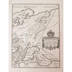
Joh. Newcombe Senator Consularis...
Unusual map of Ancient western Russia and the Caucasus, with a strangely shaped Caspian Sea. Filled with ancient place names and regions. Rare and very curious map taken ...
Date: London, 1719
Selling price: ????
Please login to see price!
Sold in 2014
Les XVII Provinces Des Pays Bas..
Decorative map of the Low Countries, extending southwards as far as the North-East of France.From Le Nouveau et Curieux Atlas Geographique et Historique.. by Jacques Chiq...
Date: Paris, 1719
Selling price: ????
Please login to see price!
Sold in 2021
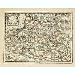
Les Estats de la Couronne de Pologne.
Lovely small map of Poland with title cartouche and a panel in the upper right corner listing local rulers.From Le Nouveau et Curieux Atlas Geographique et Historique.. b...
Date: Paris, 1719
Selling price: ????
Please login to see price!
Sold in 2014
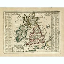
Les Royaumes D'Angleterre, D'Escosse Et D'Irlande. . .
Lovely small map of the British Isles with two side panels listing Scottish and English kings.From Le Nouveau et Curieux Atlas Geographique et Historique.. by Jacques Chi...
Date: Paris, 1719
Selling price: ????
Please login to see price!
Sold
Le Royaume de Danemark Subdivisée en ses quatre Dioceses..
Lovely small map of Denmark, with decorative title cartouche.It shows a text table in the upper left corner containing the names of local rulers.From Le Nouveau et Curieu...
Date: Paris, 1719
Selling price: ????
Please login to see price!
Sold in 2015
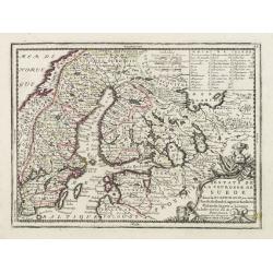
Estats de la Couronne de Suede dans la Scandinavie, ou sont Suede, Gotlande, Lapponie Suedoise, Finlande, Ingrie et Livonie. Subdivisees en leurs Provinces..
Lovely small map centered on Finland, with Sweden and much of Norway to the west, Frontieres de Moscovie to the east.Depiction of lakes, rivers and coastline reminiscent ...
Date: Paris, 1719
Selling price: ????
Please login to see price!
Sold in 2019
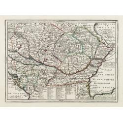
Le Royaume de Hongrie ou se trouvent La Transilvanie, La Moldavie, La Valaquie, L'esclavonie, La Bosnie, La Servie, et la Bulgarie..
Map of Hungary including most part of southeastern Europe as far as Istanbul.It shows a text table at the bottom containing the names of Hungarian rulers.From Le Nouveau ...
Date: Paris, 1719
Selling price: ????
Please login to see price!
Sold in 2016
Carte Generale D'Italie Et des Isles Adjacentes. . .
Decorative map of Italy displaying at both sides a list containing the names of the popes. In the Tyrrhenian Sea instead, a table presents a list of the Antipopes.From Le...
Date: Paris, 1719
Selling price: ????
Please login to see price!
Sold in 2023
Les Isles et Coste de la Dalmatie ou se Trouvent la Republique de Raguse..
Fine map of the Dalmatian coast with a decorative title cartouche.Presents vessels in the Adriatic Sea and some text containing information about the Republic of Ragusa, ...
Date: Paris, 1719
Selling price: ????
Please login to see price!
Sold in 2016
La Grece ou Partie Meridionale de la Turquie d'Europe. . .
Decorative map of Greece displaying precise engraving and a title cartouche flanked by 2 winged female figures, surmounted by a fan shaped shell.Another cartouche contain...
Date: Paris, 1719
Selling price: ????
Please login to see price!
Sold in 2017
Isle et Royaume de Candie.
Uncommon small map of Crete displaying precise engraving and a flourishing, banner-style cartouche.From Le Nouveau et Curieux Atlas Geographique et Historique.. by Jacque...
Date: Paris, 1719
Selling price: ????
Please login to see price!
Sold in 2014
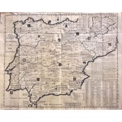
Carte Historique Et Geographique Des Royaumes D Espagne Et De Portugal Divises Selon Leurs Royaume et Provinces
Very detailed map of Spain and Portugal. Coats of arms and substantial details throughout the regions are delineated.From Chatelain's monumental Atlas Historique (in 7 vo...
Date: Amsterdam, 1719
Selling price: ????
Please login to see price!
Sold in 2014
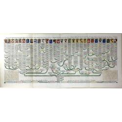
Nouvelle Carte Genealogique des Souverains et des Familles Illustres Aliez a la Maison Ouaux Decendans de la Famille Roialle de Piaste Roi de Pologne...
A genealogical tree of the Royal family of Poland from AD.804 to AD.1704. Produced as a supplement to a 7 volume "Atlas Historique" by Henry Chatelaine in1710. ...
Date: Amsterdam, 1719
Selling price: ????
Please login to see price!
Sold in 2016
Les Estats de la Couronne de Pologne.
The very rare first edition published by Antoine Menard (with his signature) in 1711 in "Le Nouveau et Curieux Atlas géographique et historique.". The map is m...
Date: Paris, 1719
Selling price: ????
Please login to see price!
Sold in 2020
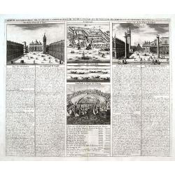
Carte du Gouvernement Militaire de la Republique du Venise...
Very decorative folio sheet with five engraved views in Venice: "Vue de la Palace de St. Marc" (Piazza San Marco), a birds-eye map of "L'Arcenal", &qu...
Date: Amsterdam, 1719
Selling price: ????
Please login to see price!
Sold in 2016
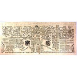
Carte Genealogique de la Maison de Nassau.
A fine, very detailed genealogical Map of the House of Nassau Orange. It is an antique engraving with the pedigrees of the House Nassau Wiesbaden and Nassau Dillenburg. T...
Date: Amsterdam, 1719
Selling price: ????
Please login to see price!
Sold in 2016
Plan Des Antiquitez De Rome Representes Et Distingues Suivant La Situation De Chacun De Ses Anciens Monuments.
Copper engraved plan of Ancient Rome, identifying over 100 a hundred buildings, bridges, churches, fountains. Taken from Chatelain's monumental 7 volume Atlas Historique,...
Date: Amsterdam, 1719
Selling price: ????
Please login to see price!
Sold in 2017
Nisen-Navgorod ville de la moscovie, Capitale du Duche de meme nom.
Decorative view of Nizhniy Novgorod (Gorky) on the Oka and Volga river. This well executed engraving was published in 1729 and 1727 by Pieter van der AA, in Leiden in &qu...
Date: Leiden, 1719
Selling price: ????
Please login to see price!
Sold in 2018
La Livonie avec les frontieres de Courlande et de Finlande . . .
Decorative map of Livonia. This well executed engraving was published in 1729 and 1727 by Pieter van der AA, in Leiden in "Les Voyages tres-curieux et tres-renommez ...
Date: Leiden, 1719
Selling price: ????
Please login to see price!
Sold in 2017
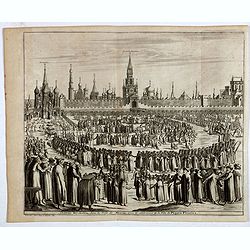
Château Kremlin, dans la ville de Moscou, avec la celebration de la fête de Pâques fleuries.
Decorative view of Kremlin during the Procession on Palm Sunday. This well executed engraving was published in 1729 and 1727 by Pieter van der AA, in Leiden in "Les ...
Date: Leiden, 1719
Selling price: ????
Please login to see price!
Sold in 2018
Moscou, capitale de la Moscovie suivant Olearius.
Decorative view of Moscow city, oriented to the west. At the base of the map there are a series of decorative views illustrating Russian hunters and farmers. A decorative...
Date: Leiden, 1719
Selling price: ????
Please login to see price!
Sold in 2017
Novogorod, ville de la Moscovie . . .
Decorative map of Novogorod, city of Moscovie. This well executed engraving was published in 1729 and 1727 by Pieter van der AA, in Leiden in "Les Voyages tres-curie...
Date: Leiden, 1719
Selling price: ????
Please login to see price!
Sold in 2017
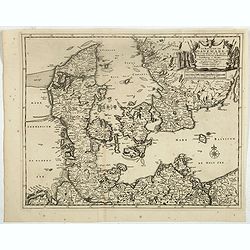
Le Royaume de Danermark . . .
Decorative map of Denmark. This well executed engraving was published in 1729 and 1727 by Pieter van der AA, in Leiden in "Les Voyages tres-curieux et tres-renommez ...
Date: Leiden, 1719
Selling price: ????
Please login to see price!
Sold in 2019

Adam Olearius . . .
Portrait of Adam Olearius. This well executed engraving was published in 1729 and 1727 by Pieter van der AA, in Leiden in "Les Voyages tres-curieux et tres-renommez ...
Date: Leiden, 1719
Selling price: ????
Please login to see price!
Sold in 2017
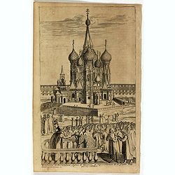
St Trinité, ou Jerusalem, Eglise de Moscou . . .
Decorative view of St Trinité church in Moscow. This well executed engraving was published in 1729 and 1727 by Pieter van der AA, in Leiden in "Les Voyages tres-cur...
Date: Leiden, 1719
Selling price: ????
Please login to see price!
Sold in 2019
La ville de Moscou, capitale de la Moscovie.
Decorative panoramic view of Moscow. Below the engraving a numbered key (1- 24) of the important buildings of the city. This well executed engraving was published in 1729...
Date: Leiden, 1719
Selling price: ????
Please login to see price!
Sold in 2017
L'Italie Dans Son Premier Etablissement Sous La Republique Romaine Dans La Division par Cesar Auguste Et Ses Differents Gouvermens Sous Les Papes.
A most fascinating map of Italy. It encompasses maps of Italy during modern times (beginning of the XVIII century), at the time of Cesear, and at the time of the beginnin...
Date: Amsterdam, 1719
Selling price: ????
Please login to see price!
Sold in 2022
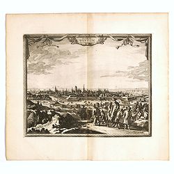
La ville de Dantzic dans la Prusse Royale.
Decorative view of Danzig. This well executed engraving was published in 1719 by Pieter van der AA, in Leiden in "Les Voyages tres-curieux et tres-renommez faits en ...
Date: Leiden, 1719
Selling price: ????
Please login to see price!
Sold in 2019
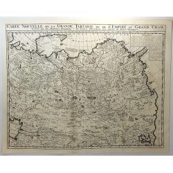
Carte Nouvelle de la Grande Tartarie ou de L'Empire du Grand Cham. . .
A strongly engraved map of Russia, from the Caspian Sea to Korea, filled with minute detail and beautifully engraved to show the topography. Inset of explanatory French t...
Date: Amsterdam, 1719
Selling price: ????
Please login to see price!
Sold in 2018
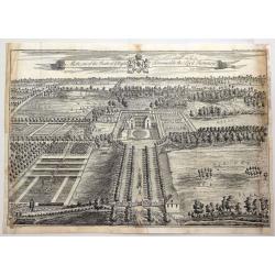
The Mote, One of the Seats of Ye Right Honorable the Lord Romney.
A fine detailed bird's eye view of 'The Mote', showing the house, gardens and the avenues of trees stretching out into the surrounding park. Title along top edge, coat of...
Date: London, 1719
Selling price: ????
Please login to see price!
Sold in 2018
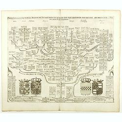
Carte Genealogique De La Maison De Stuart, Dans La Quelle L'On Fait Observer Son Origine, Ses Branches.
Fine example of Chatelain's attractive plate showing the genealogy of the House of Stuart, decorated with four coats-of-arms pertaining to military alliances. Zacharie Ch...
Date: Amsterdam, 1719
Selling price: ????
Please login to see price!
Sold in 2021
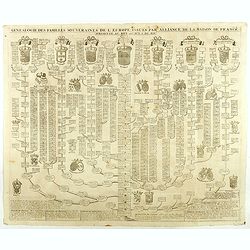
Genealogie des Familles souverains de l'Europe issues par alliance de la maison de France . . .
Fine example of Chatelain's attractive plate showing the genealogy of the important royal families of Europe, decorated with coats-of-arms. Zacharie Chatelain (d.1723) wa...
Date: Amsterdam, 1719
Selling price: ????
Please login to see price!
Sold in 2018

Nouvelle carte genealogique des principaux souverains de l'Europe issus de la Famille Roiale de France . . .
Fine example of Chatelain's attractive plate showing the genealogy of the important royal families of Europe, decorated with coats-of-arms. Zacharie Chatelain (d.1723) wa...
Date: Amsterdam, 1719
Selling price: ????
Please login to see price!
Sold in 2018
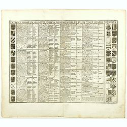
La France divisée en ses douze anciens gouvernements, et en ses vingt quarte nouveaux.
Fine example of Chatelain's attractive plate showing the division of the different governments, decorated with coats-of-arms. Zacharie Chatelain (d.1723) was the father o...
Date: Amsterdam, 1719
Selling price: ????
Please login to see price!
Sold in 2018
Nisen-Navgorod ville de la moscovie, Capitale du Duche de meme nom.
Decorative view of Nizhniy Novgorod (Gorky) on the Oka and Volga river. This well executed engraving was published in 1729 and 1727 by Pieter van der AA, in Leiden in &qu...
Date: Leiden, 1719
Selling price: ????
Please login to see price!
Sold in 2019
Carte de geographie des differents etats de la Republique de Venise. . .
A fine map of the Adriatic Sea and Gulf of Venice, extending until Athens and Peloponnese. It names islands such as Corfu, Kefalonia,, and many of the Croatian islands. I...
Date: Amsterdam, 1719
Selling price: ????
Please login to see price!
Sold in 2019
Nouvelle Carte De La Hongrie Divisee Selon ses Differents Etats, Avec une Chronologie De Ses Ducs et de ses Rois . . .
Detailed map of Hungary, extending to Bosnia, Slovenia, Temeswar, and the Saw River in the south to Moravia, and the Frontiers of Poland in the north, centered on the cou...
Date: Amsterdam, ca. 1719
Selling price: ????
Please login to see price!
Sold in 2020
Nouvelle Carte de l'Alemagne avec des Tables des Branches de la Noblesse et les Lieux les Plus Remarquables de Leurs Residance.
Detailed map of Hungary, extending to Bosnia, Slovenia, Temeswar, and the Saw River in the south to Moravia, and the Frontiers of Poland in the north, centered on the cou...
Date: Amsterdam, ca. 1719
Selling price: ????
Please login to see price!
Sold in 2020
La ville de Moscou, capitale de la Moscovie.
Decorative panoramic view of Moscow. Below the engraving a numbered key (1- 24) of the important buildings of the city. This well executed engraving was published in 1729...
Date: Leiden, 1719
Selling price: ????
Please login to see price!
Sold in 2021
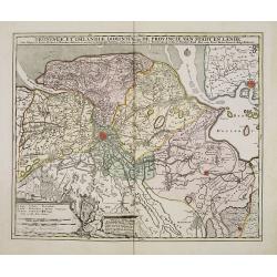
Groningae et Omlandiae Dominium vulgo De Provincie van Stadt en Lande, cum subjacent. Territ. Praefect. et Tractibus. [Lud Tjarda â Starckenburg. Nicol:Visscher. . .
Detailed map of the northern Dutch region of Groningen with figurative cartouche and coats of arms. The town of Groningen in the center, Emden just on the right. Engraved...
Date: Amsterdam, 1685/ 1720
Selling price: ????
Please login to see price!
Sold in 2017
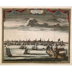
Amsterdam. Capitale de la Hollande.
A panoramic view of the town of Amsterdam seen from 't IJ.Rare.
Date: Leiden 1720
Selling price: ????
Please login to see price!
Sold
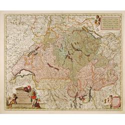
Exactissima Helvetiae, Rhaetiae, Valesia..
Engraved by A.Hogeboom. A re-issue of the map by Nicolaes Visscher. On verso a alphabetical table for locating cities in Switzerland.
Date: Amsterdam 1720
Selling price: ????
Please login to see price!
Sold in 2011
Edimbourg Ville Capitale du Royaume d'Ecosse.
"A very RARE panoramic view of the city of Edinburgh, including a numbered legend in the lower part.Published by the brothers Chéreau, active in Paris at ...
Date: Paris c.1720
Selling price: ????
Please login to see price!
Sold
Cercle d'Autriche..
Decorative map of Austria with a nice title cartouche.
Date: Leiden, c.1720
Selling price: ????
Please login to see price!
Sold
La Bohême, suivant les nouvelles observations?
With decorative title cartouche upper right corner.
Date: Leiden c.1720
Selling price: ????
Please login to see price!
Sold
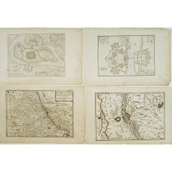
Lot : 10 maps and city views centered on the river Rhine.
Lot : 10 maps and city views centered on the river Rhine. Maps and prints by Braun and Hogenberg/ de Fer.
Date: c.1720
Selling price: ????
Please login to see price!
Sold
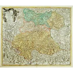
Archiducatus Austriae superioris in suas Quadrantes..
Map of the northern area of Austria. Large decorative uncolored cartouche upper left.Several cities underlined with ink, manuscript addition.
Date: Nuremberg 1720
Selling price: ????
Please login to see price!
Sold
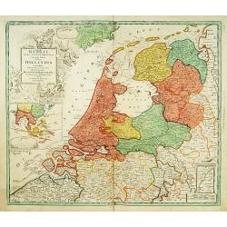
Belgii pars Septentrionalis vulgo Hollandia..
A large, decorative -colored- title cartouche at top left. In an inset -122x140mm- under the title cartouche a small map of Southeast Asia with a panoramic view of the po...
Date: Nuremberg 1720
Selling price: ????
Please login to see price!
Sold
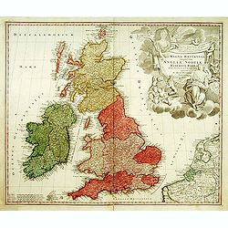
Magna Britannia?
A decorative of Britain and Ireland with great details. Includes part of France, Belgium and Holland. The large title cartouche is very decorative.
Date: Nuremberg, 1720
Selling price: ????
Please login to see price!
Sold
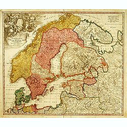
Scandinavia complectens Sueciae, Daniae & Norvegia.
Johann Baptist Homann's well-engraved map has a large decorative cartouche. Detailed map of Scandinavia. Johann Baptist Homann (1663-1724) was a German engraver and publi...
Date: Nuremberg, 1720
Selling price: ????
Please login to see price!
Sold
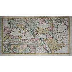
Carte de l\' Empire Othoman consideréedans les Etats de cette Puissance, et Etats qui l\' avoisinent ou qui luy sont tributaires. / Carte pour servir a l\' Histoire Universelle / Carte de la Grèce.
Henri Abraham Chatelain was a Amsterdam-based geographer and publisher. His main product is the 'Atlas Historique et Méthodique', in seven volumes, published between 171...
Date: Amsterdam, 1710 / 1720
Selling price: ????
Please login to see price!
Sold in 2009
Portsmouth.
A very fine and quite large view of Portsmouth from Joannes Kip's Britannia Illustrata or Views of Several of the Queens Palaces also of the Principal Seats of the Nobili...
Date: London 1708-1720
Selling price: ????
Please login to see price!
Sold