Browse Listings in Europe
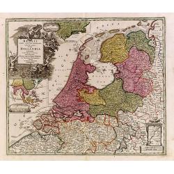
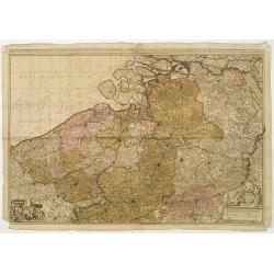
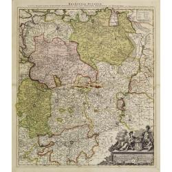
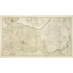
Belgii pars Septentrionalis vulgo Hollandia..
A large, decorative -colored- title cartouche at top left. In an inset -122x140mm- under the title cartouche a small map of Southeast Asia with a panoramic view of the po...
Date: Nuremberg 1720
Selling price: ????
Please login to see price!
Sold
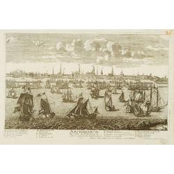
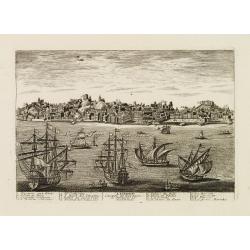
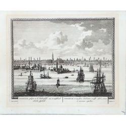
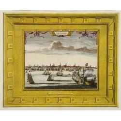
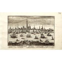
Amsterdam Ville du Comte de Hollande.
A very RARE panoramic view of the city of Amsterdam, including a legend in the lower both corners.The plate is numbered in red pencil in upper right corner.Engraved by Je...
Date: Paris 1690-1720
Selling price: ????
Please login to see price!
Sold
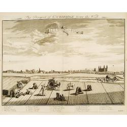
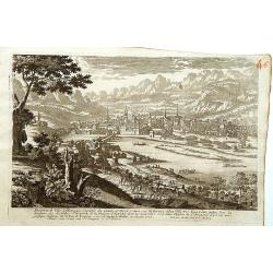
Prospect of Cambridge from the west.
A very fine and quite large view of Cambridge seen from the west, from: Britannia Illustrata or Views of Several of the Queens Palaces also of the Principal Seats of the ...
Date: London 1708-1720
Selling price: ????
Please login to see price!
Sold
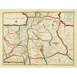
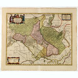
Armenia Vetus In Quatuor Partes..
Uncommon map of ancient Armenia.
Date: Amsterdam 1720
Selling price: ????
Please login to see price!
Sold
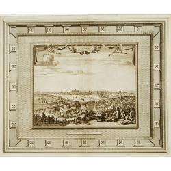
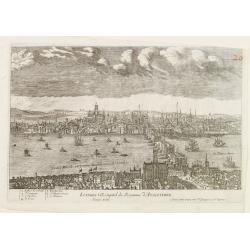
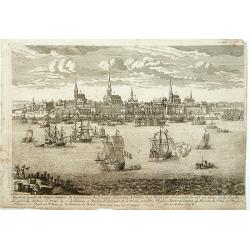
Londres capitale de l'Angleterre.
Fine and uncommon panoramic view of London. The view is printed within a large, elaborately engraved mock-frame border, which was prepared with a blank centre so that the...
Date: Leiden 1720
Selling price: ????
Please login to see price!
Sold
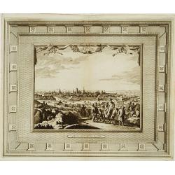
La ville de Dantzic dans la Prusse Royale.
Fine and uncommon panoramic view of Dantzig. The view is printed within a large, elaborately engraved mock-frame border, which was prepared with a blank center so that th...
Date: Leiden, 1720
Selling price: ????
Please login to see price!
Sold
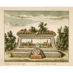
Vue de la Ville de Delft.
A very fine and decorative view of the city of Delft. Includes a title in Dutch and French underneath.
Date: Amsterdam c.1720
Selling price: ????
Please login to see price!
Sold in 2019
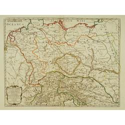
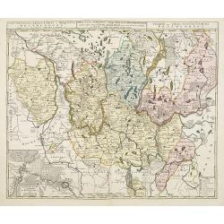
Germania Antiqua in IV. Magnos populos, in minores populos, et in minimos, distincta..
A fine map of ancient Germany, Poland and the Netherlands.Nicolas Sanson was to bring about the rise of French cartography, although the fierce competition of the Dutch w...
Date: Paris 1720
Selling price: ????
Please login to see price!
Sold in 2022
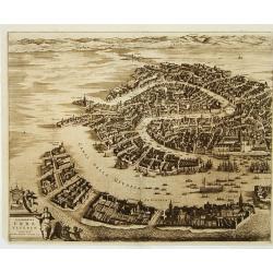
Celeberrima Urbs Venetiae. (Venice)
Precise, beautiful bird's-eye view of Venice and neighboring islands (Murano, Burano, Torcello and Mazorbo), clearly depicting the city's architectural landmark. The surr...
Date: Amsterdam 1720
Selling price: ????
Please login to see price!
Sold
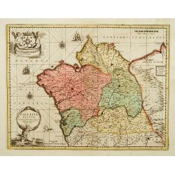
Gallaecia Regnum.
Fine map of part of Spain.
Date: Amsterdam, 1720
Selling price: ????
Please login to see price!
Sold
![Nova Helvetiae tabula geographica [Sheet 1 of 4]](/uploads/cache/17583-250x250.jpg)
Nova Helvetiae tabula geographica [Sheet 1 of 4]
Johann Jakob Scheuchzer (August 2, 1672 ? June 23, 1733) was a Swiss scholar born at Zürich. In 1712 he published, a map of Switzerland in four sheets (scale 1/290,000),...
Date: Amsterdam 1720
Selling price: ????
Please login to see price!
Sold
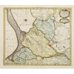
Brabantiae Ducatus
On the lower right a cartouche embellished with figures, trees, birds, fruits and the heraldic arms of Brabant, held by a female figure. At bottom a dedication to Herman ...
Date: Amsterdam 1720
Selling price: ????
Please login to see price!
Sold
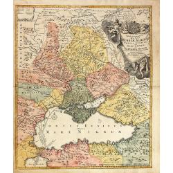
Russia Alba, sive Moscovia, regio valde extensa, divisaque in regni..
European Russia, including Ukraine.
Date: Amsterdam 1720
Selling price: ????
Please login to see price!
Sold
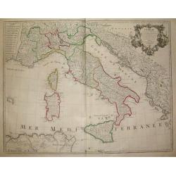
L´Italie...
Title: L´Italie. Dressée sur les Observations de Mrs. de l´Academie Royale des Sciences sur celles du R.P. Riccioli de la Compagnie de Jesus et autres Astronomes du pa...
Date: France, c. 1720
Selling price: ????
Please login to see price!
Sold in 2018
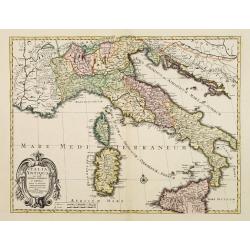
Italia Antiqua cum insulis Sicilia Sardinia..
Fine map of ancient Italy, including Sardinia and Corsica.A Amsterdam issue of the map by Nicolas Sanson.
Date: Amsterdam 1720
Selling price: ????
Please login to see price!
Sold
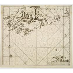
Nieuwe pascaert, vande suyt syde van Yrlandt..
Showing the south coast of Ireland.Latitude scale, compass rose and system of rhumb lines, soundings, anchorage's, etc. In lower right corner with added number 20.
Date: Amsterdam 1720
Selling price: ????
Please login to see price!
Sold
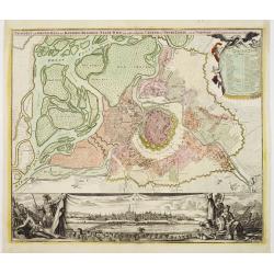
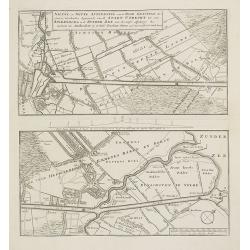
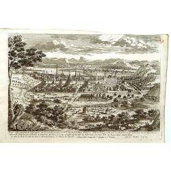
Prospect und Grund-riss.. stadt Wien.
The upper part shows Vienna with adjoining regions. The bottom part shows a prospect of the town.
Date: Nuremberg 1720
Selling price: ????
Please login to see price!
Sold
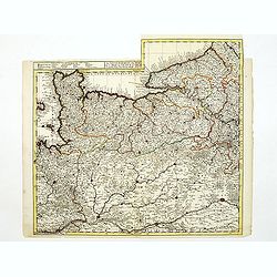
Het groot en by naar geduurige schouwburg van den Europeeschen Oorlogh behelsende Brabant, Vlanderen, Henegouwe, Namur en Luyck, etc. te Amsterdam by P.Schenk.
Rare and interesting map of Brabant, and present-day Belgium. The wall map consists of two pages, pasted together and in top a separate printed slip with its title Het gr...
Date: Amsterdam 1720
Selling price: ????
Please login to see price!
Sold
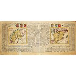
Carte Genealogique pour conduire a l' histore des Rois du Nord, la Carte de leurs etats, leurs Armes &tc. / nouvelle cart du Royaume de Suede. / Carte du Royaume de Gothie.
Henri Abraham Chatelain was a Amsterdam-based geographer and publisher. His main product is the 'Atlas Historique et Méthodique', in seven volumes, published between 171...
Date: Amsterdam, 1710-1720
Selling price: ????
Please login to see price!
Sold
Inspruck Ville d'Allemagne Capitale du Comte de Tyrol.
A very RARE panoramic view of the city of Innsbruck.The plate is numbered in red pencil in upper right corner.Engraved by Pierre Aveline (Paris, c.1656 - 23 May 1722). He...
Date: Paris, 1690-1720
Selling price: ????
Please login to see price!
Sold in 2016
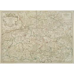
Le Gouvernement de Normandie...
Very detailed map of Normandy. In the south the river Loire, and in utmost left part of Jersey.
Date: Amsterdam, ca. 1720
Selling price: ????
Please login to see price!
Sold
Brabantiae Ducatus.
On the lower right a cartouche embellished with figures, trees, birds, fruits and the heraldic arms of Brabant, held by a female figure. At bottom a dedication to Herman ...
Date: Amsterdam, 1720
Selling price: ????
Please login to see price!
Sold in 2011
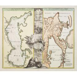
Geographica..Mare Caspium altera Kamtzadaliam..
Two maps on one sheet. On the right a fascinating and confused picture of Hokkaido, the Kuriles and Kamchatka, based on reports of recent Russian expeditions sent by Pete...
Date: Nuremberg 1720
Selling price: ????
Please login to see price!
Sold
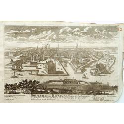
Koppenhage Hafnia Ville capitale du Royaume de Danemark.
A very RARE panoramic view of the city of Copenhagen, with a numbered legend in both lower corner.The plate is numbered in red pencil in upper right corner.Engraved by Pi...
Date: Paris 1690-1720
Selling price: ????
Please login to see price!
Sold
Londres Ville Capitale du Royaume d'Angleterre.
A very RARE panoramic view of the city of London, with a numbered legend in lower left corner.The plate is numbered in red pencil in upper right corner.Engraved by Jean C...
Date: Paris 1690-1720
Selling price: ????
Please login to see price!
Sold
Lisbone.
A very RARE panoramic view of the city of Lisbon, including a numbered legend in both lower corners.Published by the brothers Chéreau, active in Paris at rue st.Jacques ...
Date: Paris c.1720
Selling price: ????
Please login to see price!
Sold
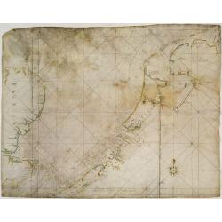
V.O.C. Chart of the Netherlands, south-eastern England and the English Channel.
V.O.C. manuscript vellum chart of the Netherlands, south-eastern England and the English Channel. Depicting the southern part of the North Sea, from the English Channel t...
Date: Amsterdam ca. 1720
Selling price: ????
Please login to see price!
Sold
Riga Capitale de la Province de Livonie.
A very RARE panoramic view of the city of Riga.The plate is numbered in red pencil in upper right corner.Engraved by Pierre Aveline (Paris, c.1656 - 23 May 1722). He was ...
Date: Paris 1690-1720
Selling price: ????
Please login to see price!
Sold
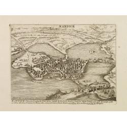
Mantoue Ville de la Lombardie Transalpine.
A very RARE panoramic view of the city of Mantua, including a numbered legend in the lower part.Published by the brothers Chéreau, active in Paris at rue st.Jacques au G...
Date: Paris, c.1720
Selling price: ????
Please login to see price!
Sold in 2010
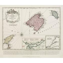
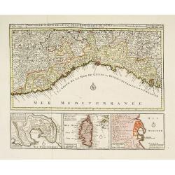
Carte des isles de Maiorque Minorque et d'Yvice..
Map of the Balearic Islands of Mallorca, Menorca and Ibiza with large cartouche and inset plan of the harbour of Mahon and a small overall map of the western Mediterranea...
Date: Augsburg 1720
Selling price: ????
Please login to see price!
Sold
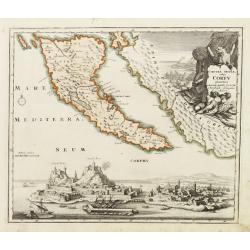
Corcyrae insulae, vulgo Corfv planities unacum parte Greciae ..
Corfu with part of the coastline of Greece, large battle-scene title vignette upper right, and panoramic view of Corfu harbour and fortress across the lower portion of th...
Date: Nuremberg 1720
Selling price: ????
Please login to see price!
Sold
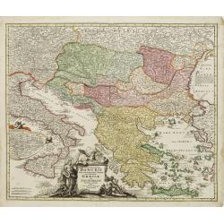
Fluviorum in Europa principis Danubii cum Adiacentibus..
Map showing the course of the river Danube from Ingolstadt to the Black Sea and the adjacent countries with Italy and Greece.In an inset the course of the river Danube fr...
Date: Nuremberg 1720
Selling price: ????
Please login to see price!
Sold
Nouvelle Carte de Pologne.
Henri Abraham Chatelain was a Amsterdam-based geographer and publisher. His main product is the 'Atlas Historique et Méthodique', in seven volumes, published between 171...
Date: Amsterdam, c.1720
Selling price: ????
Please login to see price!
Sold
Tractuum Borussiae, circa Gedanum et Elbingam..
A decorative map including Gdansk, Elblag and Malbork.
Date: Amsterdam, 1720
Selling price: ????
Please login to see price!
Sold
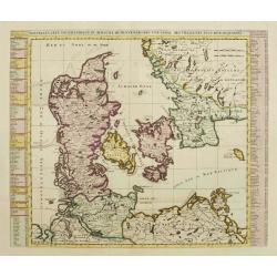
Nouvelle Carte Geographique du Royaume de Dannemarck avec une table des villes les plus remarquables.
Map of Denmark with a key table to the towns on both sides.Zacharie Chatelain (d.1723) was the father of Henri Abraham (1684-1743) and Zacharie Junior (1690-1754).They wo...
Date: Amsterdam, ca. 1720
Selling price: ????
Please login to see price!
Sold
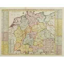
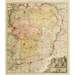
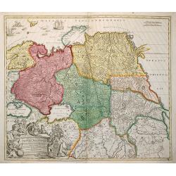
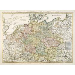
Nouvelle Carte de l'Alemagne avec des tables des branches de la noblesse..
Map of Germany including parts of the neighboring countries with a key table to the towns on both sides.Zacharie Chatelain (d.1723) was the father of Henri Abraham (1684-...
Date: Amsterdam, ca. 1720
Selling price: ????
Please login to see price!
Sold
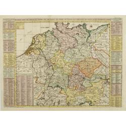
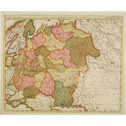
Nouvelle Carte des Cercles de l'Empire, avec des tables des divers souverains..
Map of Germany including parts of the neighboring countries with a key table to the towns on both sides.Zacharie Chatelain (d.1723) was the father of Henri Abraham (1684-...
Date: Amsterdam, ca. 1720
Selling price: ????
Please login to see price!
Sold
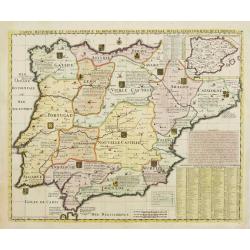
Carte Historique et Geographique des Royaumes d'Espagne et de Portugal..
Historical and geographical map of the kingdoms of Spain and Portugal divided according to their kingdoms and provinces. Including indexes, notes and an inset map of the ...
Date: Amsterdam, ca. 1720
Selling price: ????
Please login to see price!
Sold
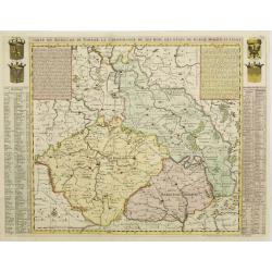
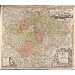
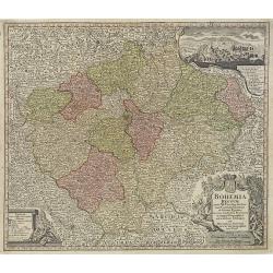
Carte du Royaume de Boheme. La chronologie de ses Rois..
Map centered on today Czech Republic, including part of Poland with a key table to the towns on both sides.Zacharie Chatelain (d.1723) was the father of Henri Abraham (16...
Date: Amsterdam, ca. 1720
Selling price: ????
Please login to see price!
Sold
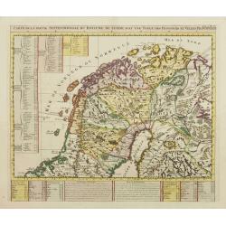
Carte de la Partie Septentrionale du Royaume de Suede?
Map of the northern part of Scandinavia. It covers the area straddling Norway, Sweden, Finland and Russia.Zacharie Chatelain (d.1723) was the father of Henri Abraham (168...
Date: Amsterdam, ca. 1720
Selling price: ????
Please login to see price!
Sold
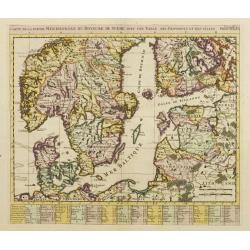
Carte de la Partie Meridionale du Royaume de Suede?
Map of the southern part of Scandinavia with letter key at the bottom.Zacharie Chatelain (d.1723) was the father of Henri Abraham (1684-1743) and Zacharie Junior (1690-17...
Date: Amsterdam, ca. 1720
Selling price: ????
Please login to see price!
Sold
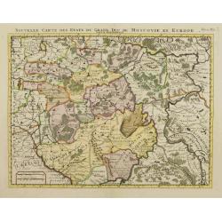
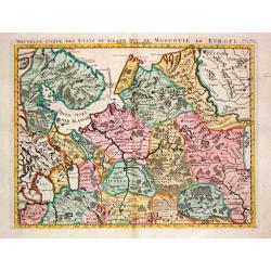
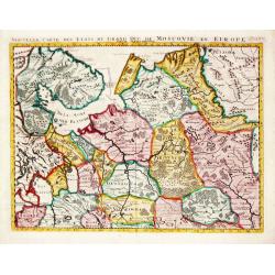
Nouvelle Carte des Etats du Grand Duc de Moscovie en Europe. Partie Meridionale.
Detailed map of central Russia. Moscow in the centre of the map, including Rzeva, Ukraine, Astracan, etc.Zacharie Chatelain (d.1723) was the father of Henri Abraham (1684...
Date: Amsterdam, ca. 1720
Selling price: ????
Please login to see price!
Sold
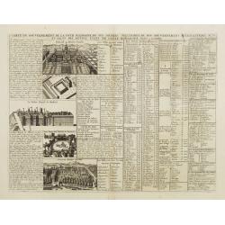
Carte du Gouvernement de la Cour d'Espagne..
This impressive engraving is a wonderful example of Chatelain's elegant plates. Ornamented with numerous vignettes.It provides a detailed description of the infrastructur...
Date: Amsterdam, ca. 1720
Selling price: ????
Please login to see price!
Sold in 2012
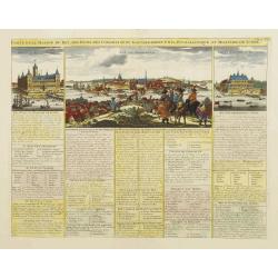
Carte de la Maison du Roi, des Etats.. de Suede.
This impressive engraving is a wonderful example of Chatelain?s elegant plates. Ornamented with 3 vignettes: Palais du Roi de Suede, Vuë de Stockholm, Vuë du château d...
Date: Amsterdam, ca. 1720
Selling price: ????
Please login to see price!
Sold in 2009
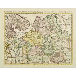
Nouvelle Carte des Etats du Grand Duc de Moscovie en Europe. Partie Sertentrionale.
Northern part of European Russia. Zacharie Chatelain (d.1723) was the father of Henri Abraham (1684-1743) and Zacharie Junior (1690-1754).They worked as a partnership pub...
Date: Amsterdam, ca. 1720
Selling price: ????
Please login to see price!
Sold
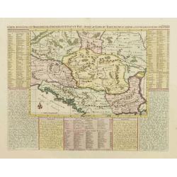
Carte ancienne et moderne des differents et Païs situez au long du Danube, pour servir a l'intelligence de l'histoire.
Handsome map of the Balkans showing the various historical regions with explanatory text and tables on three sides. The map focuses on the Danube valley, which is the mos...
Date: Amsterdam, ca. 1720
Selling price: ????
Please login to see price!
Sold
Carte génealogique pour conduire à l'Histoire des Rois du Nord, la Carte de leurs états, leurs Armes ..
Large fold out map which traces the genealogy of the royal families of Scandinavia. The royal lineage of Norway, Denmark, and Sweden are all carefully laid out across the...
Date: Amsterdam, ca. 1720
Selling price: ????
Please login to see price!
Sold
Nouvelle Carte des Etats du Grand Duc de Moscovie en Europe partie Septentrionale.
H.A. Chatelain's attractive map of the northern part of European Russia.
Date: Amsterdam, c. 1720
Selling price: ????
Please login to see price!
Sold
Dantzick.
A very RARE panoramic view of Danzig, including a numbered legend in the lower part.The plate is numbered in red pencil in upper right corner.Engraved by Jean Crepy (the ...
Date: Paris, 1690-1720
Selling price: ????
Please login to see price!
Sold in 2008
Nieuwe en nette afteekening van de door Gravinge die er Staat. . . Stadt Utrecht tot aan Spakenborg in de Zuyder Zee . . .
New and accurate map of the canal from the city of Utrecht to Spakenburg. The map was published in : Het groote tafereel der dwaasheid : vertoonende de opkomst, voortgang...
Date: Amsterdam, 1720
Selling price: ????
Please login to see price!
Sold
VENETIE, GELEGEN IN DE HADRIATISCHE ZEE IN VERSCHEIDE EILANDEN AFGEDEELT
Rare view of Venice by Pieter Schenk.
Date: Amsterdam, 1720
Selling price: ????
Please login to see price!
Sold in 2018
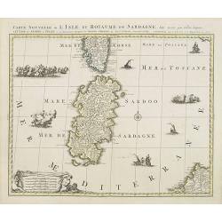
Carte nouvelle de l'Isle et royaume de Sardagne. . .
Uncommon map of Sardinia, with part of Corsica, the second-largest island in the Mediterranean Sea and an autonomous region of Italy. The Mediterranean is filled with sin...
Date: Amsterdam, 1720
Selling price: ????
Please login to see price!
Sold in 2023

Hispaniae et Portugalliae regna per Nicolaum Visscher
Outstanding example of an Iberian peninsula map showing Spain and Portugal and Balearic Islands. Two beautiful cartouches with several putti and coat of arms. Published b...
Date: Amsterdam, 1720
Selling price: ????
Please login to see price!
Sold in 2009
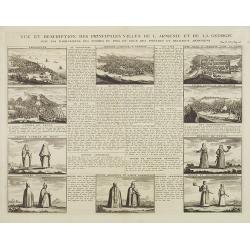
Vue et dscription des principales villes de l'Armenie et de la Georgie avec les habillements des femmes du pays, et ceux des prêtres et religieux armeniens. . .Tom: V N° 11 Pag: 28
View and description of the principal Armenian and Georgian cities with illustrations of Armenian women's garments as well as priests' and monks' clothing. The views are ...
Date: Amsterdam, ca 1720
Selling price: ????
Please login to see price!
Sold in 2013
Amsterdam Capitale de la Hollande.
A panoramic view of the town of Amsterdam seen from 't IJ. Set within a decorative border, printed from a separate plate.Uncommon.
Date: Leiden, 1720
Selling price: ????
Please login to see price!
Sold in 2008
Ducatus Luxemburgi tam in Maiores quam Minores ejusdem Ditiones accurate distinctus et exhibitus a Ioh. Bapt. Homanno Norimbergae
Old colored map of Luxembourg by J. B. Homann. With one decorative cartouche.
Date: Nuremberg, 1720
Selling price: ????
Please login to see price!
Sold in 2009
Totius Regni Galliae Sive Franciae et Navarrae novi¯ima Tabula edita Ó Io. Bapt. Homann Norimbergae
Copper engraved map of France by J. B. Homann. Covering complete France and southern part of the British Isles with many detail and one beautiful dramatic cartouche.
Date: Nuremberg, 1720
Selling price: ????
Please login to see price!
Sold in 2009
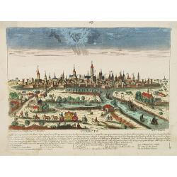
Utrecht.
A very RARE panoramic view of the city of Utrecht, including a numbered legend in the lower part.Engraved by Jean Crepy (the father) who was active as an engraver and pub...
Date: Paris, 1690-1720
Selling price: ????
Please login to see price!
Sold in 2008
Bohemia Regnum juxta XII. Circulos divisum, cum Comitatu Glacensi et ditione Egrana, nec non confinibus Provinciis in mappa Geographica accurati¯ime delineatum per Matthaeum Seutter
Large original old colored map of Bohemia by M. Seutter. With two decorative cartouches and a city view of Carlsbad. Centered around Prague (Praha).
Date: Augsburg, 1720
Selling price: ????
Please login to see price!
Sold in 2009
Typus Generalis Ukrainae sive Palatinatuum Podoliae, Kioviensis et Braczlaviensis terras nova delineatione exhibens. . .
Keymap based on Guillaume La Vasseur de Beauplan's map of the region published in "Description d'Ukraine". The work described Ukraine as several provinces of th...
Date: Amsterdam, ca. 1720
Selling price: ????
Please login to see price!
Sold in 2022
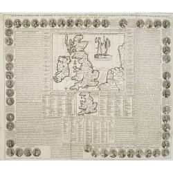
Carte Pour l'Introduction a l'Histoire d'Angleterre, ou l'on Voit son Premier Gouvernement, et l'Etat Abrege de cette Monarchie sous les Empereurs Romains, et sous les Rois Saxons.
The sheet includes a large inset map of Roman Britain including the English Channel and the western coast of France (200 x 255mm.). It also provides a wealth of informati...
Date: Amsterdam, 1720
Selling price: ????
Please login to see price!
Sold in 2009
Le Comté de Haynaut, Divisé en Chatellenies, Balliages, Prevostés. Le Cambresis. Dédié au Roy . . .
Map of the county of Hainaut with its most important cities, Mons (Bergen), Cambrai (Kamerijk) and Charleroi. Also including Hainaut, who territorially is divided between...
Date: Paris, 1720
Selling price: ????
Please login to see price!
Sold in 2010
Bohemia Regnum juxta XII. Circulos divisum, cum Comitatu Glacensi et ditione Egrana, nec non confinibus Provinciis in mappa Geographica accuratissime delineatum per Matthaeum Seutter.
Decorative and uncommon map of Bohemia by M. Seutter. With two decorative cartouches and a city view of Carlsbad, with a numbered key. Centered around Prague.
Date: Augsburg, 1720
Selling price: ????
Please login to see price!
Sold in 2010
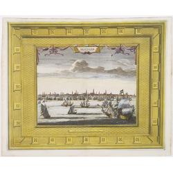
Amsterdam Capitale de la Hollande.
A panoramic view of the town of Amsterdam seen from 't IJ. Set within a decorative border, printed from a separate plate. Rare.
Date: Leiden, 1720
Selling price: ????
Please login to see price!
Sold in 2009
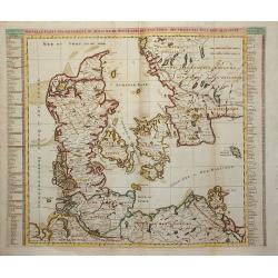
Nouvelle Carte Geographique du Royaume de Dannemarck avec une table des villes les plus remarquables.
Map of Denmark with a key table to the towns on both sides.Zacharie Chatelain (d.1723) was the father of Henri Abraham (1684-1743) and Zacharie Junior (1690-1754).They wo...
Date: Amsterdam, ca. 1720
Selling price: ????
Please login to see price!
Sold in 2011
Generalis totius Imperii Moscovitici ?
Decorated title cartouche includes several classical, allegorical and historical figures. Illustrations on map include two masted ships, four boats, and two sea creatures...
Date: Nuremberg, 1720
Selling price: ????
Please login to see price!
Sold in 2009
Bude Ville capitale de la Hongrie.
A rare panoramic of Budapest.The plate is numbered in red pencil in upper right corner.Engraved by Pierre Aveline (Paris, c.1656 - 23 May 1722). He was also a print-publi...
Date: Paris, 1690-1720
Selling price: ????
Please login to see price!
Sold in 2009
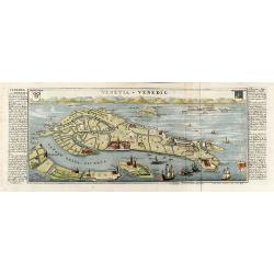
Venetia - Venedig
Beautiful colored birdeye view of Venice by Gabriel Bodenehr. Showing the important buildings, several sailing ships and German description on both sides. Printed from tw...
Date: Augsburg, 1720
Selling price: ????
Please login to see price!
Sold in 2010
![Nouvelle carte de la Suisse. Divisée en ses treize cantons. . . [4 sheets]](/uploads/cache/01476-250x250.jpg)
Nouvelle carte de la Suisse. Divisée en ses treize cantons. . . [4 sheets]
Prepared by Johann Jakob Scheuchzer (1672-1733), physician and geographer of Zürich. In 1712 he published a map of Switzerland in four sheets (scale 1/290,000), of which...
Date: Amsterdam, 1720
Selling price: ????
Please login to see price!
Sold in 2011
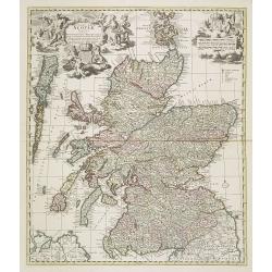
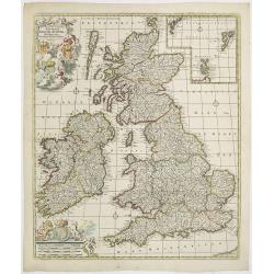
Exactissima Regni Scotiae Tabula tam in septentrionalem et meriodionalem quam in minores earundem provincias insulesq, et undique praetensas accurate . , ,
A magnificent and detailed map of Scotland, with all the counties, cities and towns, castles and churches, lochs, rivers and streams shown. This example with the imprint ...
Date: Amsterdam, 1690 -1720
Selling price: ????
Please login to see price!
Sold in 2018
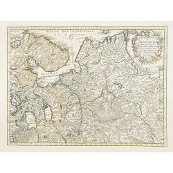
Carte nouvelle de Moscovie represente la partie Septentrionale dressée par G.De L'Isle. . .
Rare map covering the area north of Moscow, including Lapland. Prepared by G. de L'Isle.
Date: Amsterdam, 1720
Selling price: ????
Please login to see price!
Sold in 2009
Tabula Nova Provinciae Ultrajectinae. . .
Prepared by Nicolas Visscher, now published by Petrus Schenk. Shows the land development in Gelderland, Holland, near the Zuyder Zee and it shows Arnhem, Doesburg, Zutphe...
Date: Amsterdam, 1720
Selling price: ????
Please login to see price!
Sold in 2014
Carte nouvelle de l'electorat et marquisat de Brandebourg. . . / Nova electoratus et marchionatus Brandenburgici. . . / Charte des Chur-Furstenthums Brandenburg
Uncommon map centered on Berlin. In lower left inset of the area between Berlin and Spandow.Joachim Ottens (1663 - 1719) and his sons Renier and Joshua were prominent Dut...
Date: Amsterdam, 1720
Selling price: ????
Please login to see price!
Sold in 2017
Novissima prae caeteris aliis accuratissima Regnorum Angliae Angliae, Scotiae, Hiberniae . . .
The title of De Wit's map is within a banner supported by winged cherubs and cavorting mermaids. Armorial shields of England, Scotland and Ireland are placed in the left-...
Date: Amsterdam, c.1720
Selling price: ????
Please login to see price!
Sold in 2009
Anvers.
A very RARE panoramic of Antwerp, including a numbered legend in both lower corners and several very fine ships.Published by the brothers Chéreau, active in Paris at ru...
Date: Paris, c. 1720
Selling price: ????
Please login to see price!
Sold in 2018
Nouvelle Carte de l'Etat de la Republique de Genes. Dressé sur les mémoires les plus nouveaux. . .
Uncommon map of the Ligurian coast around Genoa in northern Italy with three insets below of the harbors of Genoa and Bastia and the island of Corsica. Joachim Ottens (16...
Date: Amsterdam, ca. 1720
Selling price: ????
Please login to see price!
Sold in 2022
Routes des postes et des voitures pour les marchandises et pour les voyages . . .
Uncommon post route map and commercial roads of Germany, the Low Countries, Pologne, Switzerland, Austria, and Northern Italy, published by the well-known map makers and ...
Date: Amsterdam, 1720
Selling price: ????
Please login to see price!
Sold in 2014
Lubeck Ville Imperiale du Banc du Rhein.
A RARE panoramic of the city of Lubeck.The plate is numbered in red pencil in upper right corner.Engraved by Pierre Aveline (Paris, c.1656 - 23 May 1722). He was also a ...
Date: Paris, 1690-1720
Selling price: ????
Please login to see price!
Sold in 2023
Tabula Geographica qua pars Russiae Magnae Pontus Euxinus seu Mare Nigrum et Tartaria Minor.
Unusual map of South Russia with the Black Sea region and the Ukraine. Extends from Moscow to Constantinople. The waters of the Dnieper and Danube are shown as currents i...
Date: Nuremberg, 1720
Selling price: ????
Please login to see price!
Sold in 2010
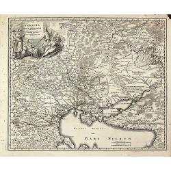
Ukrania quae et Terra Cosaccorum cum vicinis Walachiae, Moldaviae, Minorisq., Tartariae Provinciis exhibita.
Beautiful map of the Ukraine with the Black Sea and Crimea. Extends from Moscow to Constantinople. With a marvelous figural cartouche composed of native figures. Publishe...
Date: Nuremberg, 1720
Selling price: ????
Please login to see price!
Sold in 2010