Subscribe to be notified if similar examples become available.
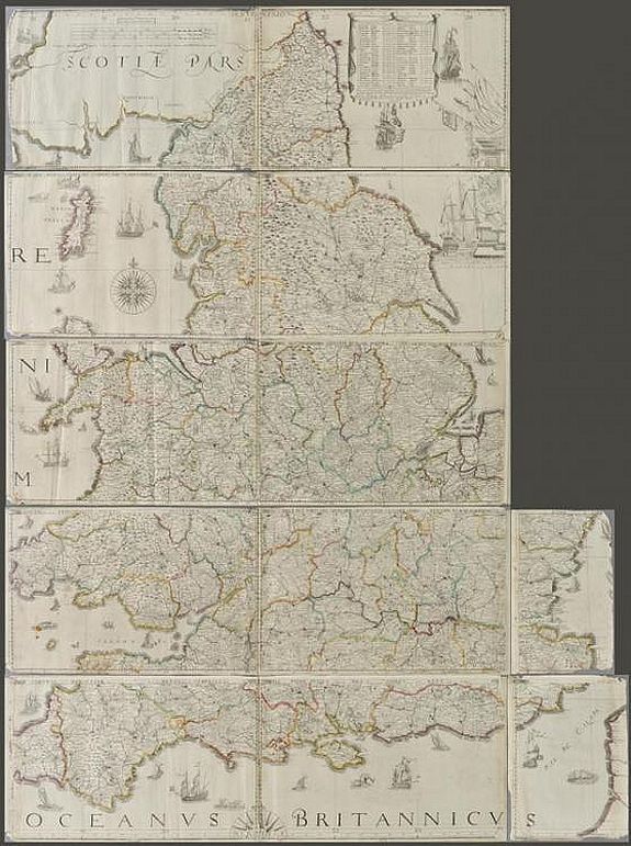
The Travellers Guide being the best Mapp of the Kingdom of England and Principality of Wales. (England & Wales wall map sections). |
||||||||||||||||||||
|
||||||||||||||||||||
|
|
||||||||||||||||||||
|
Selling price: $ Please login to see price!
Sold in 2020 Missed this item! Add your name to our mailing list and be the first to get notified about our newly added listings. . |
My Collection + - Save and collect this or any of your favorite items in one place.
If you want to save the items permanently, please sign in or create account first. |
|||||||||||||||||||
Description
Fith state of Philip Lea's version of Christopher Saxton's large scale map of England and Wales first published in 1583; this state published Philip Lea, Globe maker at ye Atlas and Hercules in Cheapside nere the corner of Fryday Street in London, [1687-1700].
Engraved map on 12 sheets (of 15): ten larger sheets approximately 285 x 425 mm, two smaller sheets approximately 285 x 200 mm. Overall size if combined: 1425 height x 1050 mm width.
Half compass rose, table of longitude and latitude of principal towns, some fraying to map strip margins, is lacking two smaller portions (East coast of Norfolk & Suffolk and South West Cornwall).
Christopher Saxton published his twenty sheet wall map in 1583. It was re-issued by Cade & Morgan in 1678. Philip Lea acquired the copper plates in about 1685 and re-published the map on a smaller scale designed to be used as a traveling map.
He reduced the map to ten full sheets and four half sheets and removed a great deal of the sea, thus making the map relevant to land-based travelers.
It appears that three of these half sheets are lacking from this example.
Philip Lea re-engraved the plates at least five times during his period of ownership. This example is his 5th and final state and therefore state 7 of a total of nine states.
Philip Lea moved from Poultry to Cheapside in 1687 and remained there until 1700. Following Lea's death, Anne, his widow, re-engraved and re-issued the map with Richard Glynne in 1720, and Thomas & John Bowles & Son repeated this in 1758. Scarce.
Complete title: 'The Travellers Guide being the best Mapp of the Kingdom of England and Principality of Wales Wherein are Delineated 3000 Towns & Villages more than in any Mapp yet Extent besides ye Notations of Bridges & Rivers &c. To which is added ye Direct and cross Roads according to Mr. Ogilby's late Survey. Described by C. Saxton And now carefully Corrected with New Additions by Phillip Lea'.
Examples of Saxton’s map, in any form, rarely come to market.
Reference: R.W.SHirley. Early Printed Maps of the British Isles 1477 - 1650, no.137, state 5.
FAQ - Guarantee - Shipping
Buying in the BuyNow Gallery
This item is available for immediate purchase when a "Add to Cart" or "Inquire Now" button is shown.
Items are sold in the EU margin scheme
Payments are accepted in Euros or US Dollars.
Authenticity Guarantee
 We provide professional descriptions, condition report (based on 45 years experience in the map business)
Paulus Swaen warrants the authenticity of our items and a certificate of authenticity is provided for each acquired lot.
Condition and Coloring
We indicate the condition of each item and use our unnique HiBCoR grading system in which four key items determine a map's value: Historical Importance, Beauty, Condition/Coloring and Rarity.
Color Key
We offer many maps in their original black and white condition. We do not systematically color-up maps to make them more sellable to the general public or buyer.
Copper engraved or wood block maps are always hand colored. Maps were initially colored for aesthetic reasons and to improve readability. Nowadays, it is becoming a challenge to find maps in their original colors and are therefor more valuable.
We use the following color keys in our catalog:
Original colors; mean that the colors have been applied around the time the map was issued.
Original o/l colors; means the map has only the borders colored at the time of publication.
Colored; If the colors are applied recently or at the end of the 20th century.
Read more about coloring of maps [+]
Shipping fee
A flat shipping fee of $ 30 is added to each shipment by DHL within Europe and North America. This covers : International Priority shipping, Packing and Insurance (up to the invoice amount).
Shipments to Asia are $ 40 and rest of the world $50
We charge only one shipping fee when you have been successful on multiple items or when you want to combine gallery and auction purchases.
Read more about invoicing and shipping
FAQ
Please have a look for more information about buying in the BuyNow gallery
Many answers are likely to find in the general help section.
My Collection+
![]()
With My Collection+ you can collect all your favorite items in one place. It is free, and anyone can create his or her virtual collection.
Unless you are logged in, the item is only saved for this session. You have to be registed and logged-in if you want to save this item permanently to My Collection+.
Read More[+]
Register here, it is free and you do not need a credit card.
Add this item to
My Collection+
or click the following link to see My Collection+.
| Digital Image Download | |
|
Paulus Swaen maintains an archive of most of our high-resolution rare maps, prints, posters and medieval manuscript scans. We make them freely available for download and study. Read more about free image download |
Click the image for a free small image download. |
In accordance with the EU Consumer Rights Directive and habitually reside in the European Union you have the right to cancel the contract for the purchase of a lot, without giving any reason.
The cancellation period will expire 14 calendar days from the day after the date on which you or a third party (other than the carrier and indicated by you) acquires, physical possession of the lot. To exercise the right to cancel you must inform Paulus Swaen Inc, of your decision to cancel this contract by a clear statement (e.g. a letter sent by post, or e-mail (amsterdam@swaen.com).
To meet the cancellation deadline, it is sufficient for you to send your communication concerning your exercise of the right to cancel before the cancellation period has expired.
