Browse Listings in Europe

Toulouse. Vue du Pont de pierre prise du Quai de Brienne. N°293.
Lithographed view of St. Pierre bridge in Toulouse by C.Mercereau who made the design at the spot and afterwards the lithography.Included in "La France de nos jours&...
Date: Paris, 1860
Selling price: ????
Please login to see price!
Sold
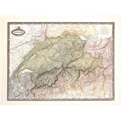
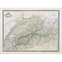
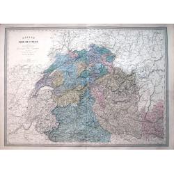
Suisse.
Detailed map of Switzerland and surrounding regions. It comes from "ATLAS SPHEROIDAL & UNIVERSEL DE GEOGRAPHIE". published in Paris by Jules Renouard in 186...
Date: Paris, 1860
Selling price: ????
Please login to see price!
Sold in 2017
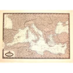
Carte Generale du Bassin de La Mer Mediterranee.
Detailed map of the Mediterranean and surrounding regions. It comes from "ATLAS SPHEROIDAL & UNIVERSEL DE GEOGRAPHIE". published in Paris by Jules Renouard ...
Date: Paris, 1860
Selling price: ????
Please login to see price!
Sold in 2016

Bataille de Solferino. Pendant que ladivision Forey s'emparait du cimetiére et
Showing the battle of de Solfererino, in Italy. Lithographed by H.Jannin, rue des Bernardins, Paris.Underneath the print a explanation "Pendant que la division Forey...
Date: Paris, ca. 1860
Selling price: ????
Please login to see price!
Sold in 2025
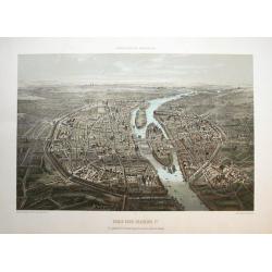
Paris sous Francois 1er. Vue générale à vol d'oiseau...
Fantastic color lithographed birds-eye view of Paris. Published by Charpentier in "Paris dans sa splendeur".
Date: Paris, ca. 1860
Selling price: ????
Please login to see price!
Sold in 2016

Moscau von der kreml-Seite.
View of Moscow with in the background the Kremlin. Original steel engraving, published by Bibliographisches Institut Hildburghausen.
Date: Hildburghausen, ca. 1860
Selling price: ????
Please login to see price!
Sold in 2016
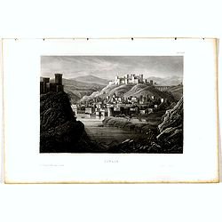
Tiflis.
View of Tiflis. Original steel engraving, published by Bibliographisches Institut Hildburghausen.
Date: Hildburghausen, ca. 1860
Selling price: ????
Please login to see price!
Sold in 2020
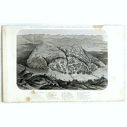
Plan of Attack & Defences of the South & North Sides of Harbour & Town of Sebastopol.
Scene during Crimean (Russo-Turkish) War 1853-1856. Bird's-eye plan of the harbour and town of Sebastopol Sevastopol) with the retreat of the Russians. Steel engraved pla...
Date: London, James S Virtue, 1860
Selling price: ????
Please login to see price!
Sold in 2017
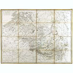
Pays-Bas en 4 Feuilles.
Uncommon map of present-day Belgium. Engraved by P.F.Tardieu. Text engraved by Aubertz.
Date: Paris, 1860
Selling price: ????
Please login to see price!
Sold in 2019
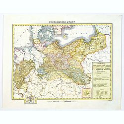
Preussischer Staat.
Map of the Prussian state showing Posen, Pommern, Brandenburg, Sachsen, Westphalia, Rheinprovinz, Preussen. Nicely colored. Inset of Neufchatel, and a legend box.Cities s...
Date: Glogau/Leipzig, ca 1860
Selling price: ????
Please login to see price!
Sold in 2019
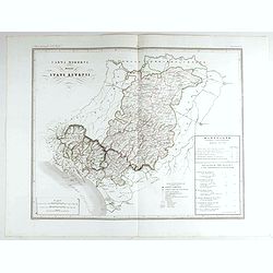
Carta moderna degli Stati Estensi.
Very finely engraved and detailed map of Emilia Romagna, Italy, Liguria, TuscanyWith a key on the right part of the map. Engraved by Vettorio Angeliand included in: Atlan...
Date: Rome, 1860
Selling price: ????
Please login to see price!
Sold in 2023
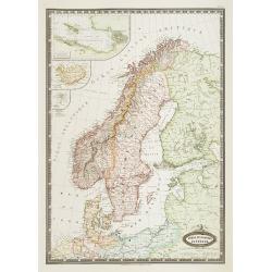
Suede et Norvege. Danemark.
Very detailed map from "Atlas Spherodidal & Universel de geographie," Prepared by F.A.Garnier and edited by Jules Renouard, rue de Tournon, Paris. Uncommon ...
Date: Paris 1861
Selling price: ????
Please login to see price!
Sold
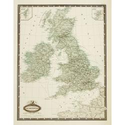
Isles Britanniques carte des chemins de fer et canaux.
Very detailed map from Atlas Sphéroïdal & Universel de géographie , Prepared by F.A.Garnier and edited by Jules Renouard, rue de Tournon, Paris. Uncommon map with ...
Date: Paris, 1861
Selling price: ????
Please login to see price!
Sold in 2011
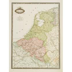
Belgique & Hollande.
Very detailed map from Atlas Sphéroïdal & Universel de géographie. Prepared by F.A.Garnier and edited by Jules Renouard, rue de Tournon, Paris. Uncommon map with d...
Date: Paris 1861
Selling price: ????
Please login to see price!
Sold in 2020
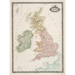
Isles Britanniques, Angleterre, Ecosse, Irlande. . .
Very detailed map from Atlas Sphéroïdal & Universel de géographie, Prepared by F.A.Garnier and edited by Jules Renouard, rue de Tournon, Paris. Uncommon map with d...
Date: Paris, 1861
Selling price: ????
Please login to see price!
Sold in 2011
Suisse.
Very detailed map from Atlas Sphéroïdal & Universel de géographie , Prepared by F.A.Garnier and edited by Jules Renouard, rue de To...
Date: Paris, 1861
Selling price: ????
Please login to see price!
Sold in 2010
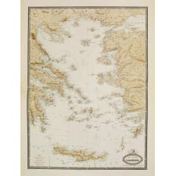
Carte Generale de L'Archipel.
Very detailed map from Atlas Sphéroïdal & Universel de géographie. Prepared by F.A.Garnier and edited by Jules Renouard, rue de Tournon, Paris. Uncommon map with d...
Date: Paris, 1861
Selling price: ????
Please login to see price!
Sold in 2022
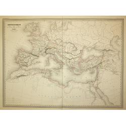
Empire Romain
The Roman Empire, from Atlas Universel Physique, Historique, Politique de Géographie Ancienne et Moderne printed by Louis Antoine and published by Armand le Chevalier in...
Date: Paris, 1861
Selling price: ????
Please login to see price!
Sold in 2011
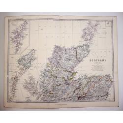
Scotland on Two sheets North and South
Scotland divided onto two large sheets. Scotland, northern sheet,page 7. by Keith Johnston, F.R.S.E. Engraved & printed by W. & A.K. Johnston, Edinburgh. William ...
Date: Edinburgh, 1861
Selling price: ????
Please login to see price!
Sold in 2019
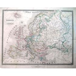
Europe.
Interesting map of Europe with its geography and territories around 1861! Published by Dufour. A large and detailed map with attractive coloring indicating the borders.
Date: Paris, 1861
Selling price: ????
Please login to see price!
Sold in 2013
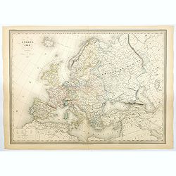
Europe en 1789 (1861).
A large, highly significant and detailed map of Europe as it appeared in 1789 - on the very eve of the French revolution - something that would have a profound and lastin...
Date: Paris, 1861
Selling price: ????
Please login to see price!
Sold in 2020
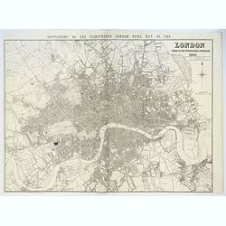
London Guide to the International Exhibition 1862
A very large and impressive plan of London, published specifically for the city's international exhibition of 1862. The exposition was a world's fair, seven years after t...
Date: London, ca 1862
Selling price: ????
Please login to see price!
Sold
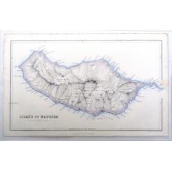
Island of Madeira.
Fine map of Madeira, one of the Portugese Islands in the Atlantic Ocean. Published by Fullerton & Company in 1862.
Date: Edinburgh, 1862
Selling price: ????
Please login to see price!
Sold in 2016
London. Guide to the International Exhibition.
Published as a supplement to the ILN of May 24th, 1862, this is a large, wonderfully detailed plan of London, extending from Hammersmith in the west, to Poplar in the eas...
Date: London, 1862
Selling price: ????
Please login to see price!
Sold in 2017
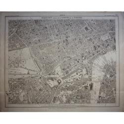
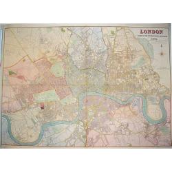
Stanford's Library Map of London and its Suburbs, sheet 10.
Published by Edward Stanford, 6 Charing Cross, London, February 15, 1862. Sheet no 10 covers the West End of London to the Houses Parliament and the Thames at Westminste...
Date: London, 1862
Selling price: ????
Please login to see price!
Sold in 2020
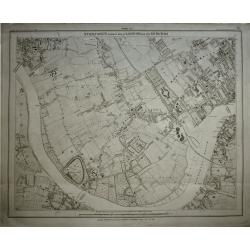
Stanford's Library Map of London and its Suburbs, sheet 13.
Published by Edward Stanford, 6 Charing Cross, London, February 15, 1862. Sheet no 13 covers West London... The Kings road in fields. The Thames from Hammersmith Bridge t...
Date: London, 1862
Selling price: ????
Please login to see price!
Sold in 2019
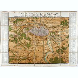
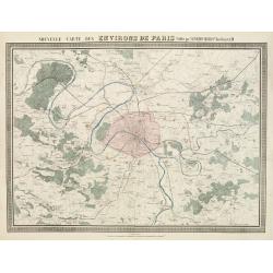
Environs de Paris. Nouvel Atlas Topographique comprenant pour chaque Etat les villes d'industrie et de commerce, les places fortifiées, les chemins de fer, les canaux etc.
A bird's eye-view of Paris and vicinity by Guittet. Centered on Paris and the Seine River and including Versailles, St. Germain, Neuilly, Orly, etc.Paris, in pink, shown ...
Date: Paris, ca. 1862
Selling price: ????
Please login to see price!
Sold in 2021
Carte generale des Chemins de fer de la Russie..
Fine map of Russia, Scandinavia, Germany, showing the early railway system of the area. From Atlas des Chemins de Fer published by Napoléon Chaix and printed by Imprimer...
Date: Paris 1863
Selling price: ????
Please login to see price!
Sold in 2008
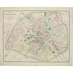
Nouveau Plan de Paris divisé en 20 arrondissements.
Detailed plan of Paris and its 20 arrondissements. Also shown are the railway system of the city with its railway stations.From Atlas des Chemins de Fer published by Napo...
Date: Paris 1863
Selling price: ????
Please login to see price!
Sold in 2010
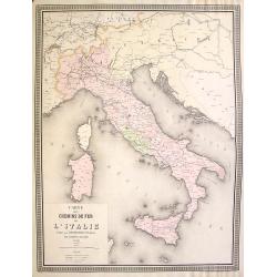
Carte des chemins de fer de l'Italie.
Detailed map of Italy, Sicily, Corsica and Sardinia. Shown are the railway systems of the country at an early stage.From Atlas des Chemins de Fer published by Napoléon C...
Date: Paris 1863
Selling price: ????
Please login to see price!
Sold in 2021
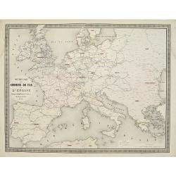
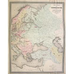
Nouvelle carte des chemins de fer de Europe.
Detailed map of Europe showing its railway systems at this early stage.From Atlas des Chemins de Fer published by Napoléon Chaix and printed by Imprimerie et librairie c...
Date: Paris 1863
Selling price: ????
Please login to see price!
Sold in 2011
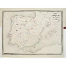
Carte des chemins de fer de l'Espagne et du Portugal. . .
Fine map of Spain and Portugal, showing the early railway system of the area. From Atlas des Chemins de Fer published by Napoléon Chaix and printed by Imprimerie et libr...
Date: Paris, 1863
Selling price: ????
Please login to see price!
Sold in 2011
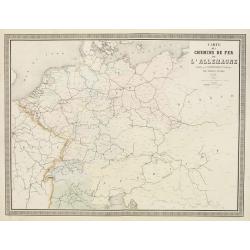
Carte des Chemins de Fer de l'Allemagne.
Fine map of Germany, The Netherlands and Eastern Europe, showing the early railway system of the area. From Atlas des Chemins de Fer published by Napoléon Chaix and pri...
Date: Paris, 1863
Selling price: ????
Please login to see price!
Sold in 2011
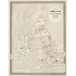
Nouvelle Carte des Chemins de Fer de la Grande Bretagne et de l'Irlande. . .
Fine map of England, Scotland and Ireland showing the early railway system of the area.From Atlas des Chemins de Fer published by Napoléon Chaix and printed by Imprimeri...
Date: Paris, 1863
Selling price: ????
Please login to see price!
Sold in 2011
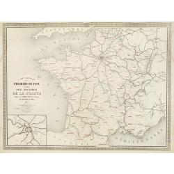
Carte Générale des Chemins de Fer et des Voies Navigables de la France.
Fine map of France, showing the early railway system of the area as well as the navigable rivers and canals.With inset map of the surrounding area of Paris in the lower l...
Date: Paris, 1863
Selling price: ????
Please login to see price!
Sold in 2011
Nouvelle Carte des Environs de Paris.
Fine map of Paris and its contiguous outskirts, showing the early railway system of the area.From Atlas des Chemins de Fer published by Napoléon Chaix and printed by Imp...
Date: Paris, 1863
Selling price: ????
Please login to see price!
Sold in 2011
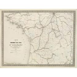
Carte du Chemin de Fer d'Orléans..
Fine map showing the early railway system of a large area extending westwards and southwards from Paris.From Atlas des Chemins de Fer published by Napoléon Chaix and pri...
Date: Paris 1863
Selling price: ????
Please login to see price!
Sold in 2011
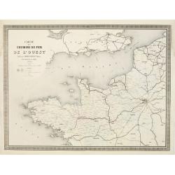
Carte des Chemins de Fer de l'Ouest..
Fine map showing the early railway system of a large area extending westwards from Paris as far as the coasts of Brittany.It includes part of the northern regions and the...
Date: Paris 1863
Selling price: ????
Please login to see price!
Sold
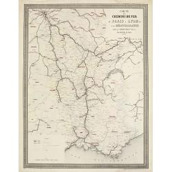
Carte des Chemins de Fer de Paris à Lyon et à la Méditerranée.
Fine map showing the early railway system of a large area extending from Paris to South East France.From Atlas des Chemins de Fer published by Napoléon Chaix and printed...
Date: Paris 1863
Selling price: ????
Please login to see price!
Sold in 2011
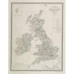
Map of the United Kingdom of Great Brittain and Ireland.
Very detailed map of Great Britain and Ireland. Lower left statistic table and upper left inset map of Shetland Islands.James Wyld (the younger) was geographer to the Que...
Date: London, 1863
Selling price: ????
Please login to see price!
Sold in 2009
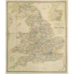
A Map of England, Wales & Scotland..
Very detailed map of England, Wales and Scotland. In upper right hand corner inset map of northern part of Scotland.James Wyld (the younger) was geographer to the Queen a...
Date: London, 1863
Selling price: ????
Please login to see price!
Sold in 2023
Russland.
This is a rare decorative map of Russia with informative borders, published in Brockhaus' Illustrierter Handatlas .
Date: Leipzig, 1863
Selling price: ????
Please login to see price!
Sold in 2011
Der Osterreichische Kaiserstaat Entworfen von Herm. Berghaus. . .
Very detailed large-scale 19th century folding map of Austria, published in the birth year of Franz Ferdinand, became Archduke of Austria. Covers from Northern part of It...
Date: Gotha, Justus Perthes, 1863
Selling price: ????
Please login to see price!
Sold in 2014

A set of 16 humorous woodblock prints from the Russian Empire's war with the French and British Empire's.
This set of 16 are from 1853 - 1863, mostly engraved by Joseph Swain. Joseph Swain was one of the most important woodblock engravers.Punch was responsible for the word se...
Date: London, 1853 - 1863
Selling price: ????
Please login to see price!
Sold in 2015

A set of 16 humorous woodblock prints from the Russian Empire's war with the French and British Empire's.
This set of 16 are from 1853 - 1863, mostly engraved by Joseph Swain. Joseph Swain was one of the most important woodblock engravers. Punch was responsible for the word s...
Date: London 1853 - 1863
Selling price: ????
Please login to see price!
Sold in 2015
![[4-sheets] Ireland.](/uploads/cache/39116-250x250.jpg)
[4-sheets] Ireland.
Large four-sheet map of Ireland by Edward Weller, published in the 'Dispatch Atlas'. Map consists of a N.E. sheet, a S.E. sheet, a N.W. sheet, which bears the title, and ...
Date: London, 1863
Selling price: ????
Please login to see price!
Sold in 2017
![[4-sheets] Wales.](/uploads/cache/39117-250x250.jpg)
[4-sheets] Wales.
Large four-sheet map of Wales by Edward Weller, published in the 'Dispatch Atlas'.Map consists of a N.E. sheet, from Montgomeryshire up to the River Dee, a S.E. sheet fro...
Date: London, 1863
Selling price: ????
Please login to see price!
Sold in 2017
![[4-sheets] Scotland.](/uploads/cache/39118-250x250.jpg)
[4-sheets] Scotland.
Large four-sheet map of Scotland by Edward Weller, published in the 'Dispatch Atlas'.Map consists of a N.W. sheet, from, the Western Isles, Skye, to parts of Ross and Sut...
Date: London, 1863
Selling price: ????
Please login to see price!
Sold in 2017
![[4-sheets] England and Wales.](/uploads/cache/39119-250x250.jpg)
[4-sheets] England and Wales.
Large four-sheet map of England and Wales by Edward Weller, published in the 'Dispatch Atlas'.Map consists of a S.E. sheet, showing London and the 'Home Counties', a S.W....
Date: London, 1863
Selling price: ????
Please login to see price!
Sold in 2017
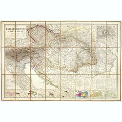
Der Osterreichische Kaiserstaat Entworfen von Herm. Berghaus. . .
Very detailed large-scale 19th century folding map of Austria, published in the birth year of Franz Ferdinand, became Archduke of Austria. Covers from Northern part of It...
Date: Gotha, Justus Perthes, 1863
Selling price: ????
Please login to see price!
Sold in 2023
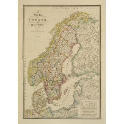
A new map of Sweden and Norway.
Very detailed map of Sweden, Norway, Denmark and Finland. Indicated are railways and Canals.James Wyld (the younger) was geographer to the Queen and H.R.H. Prince Albert....
Date: London, 1855/1864
Selling price: ????
Please login to see price!
Sold in 2018

A set of 15 prints from Punch or The London Charivari 1860 - 1864 relating to Giuseppe Garibaldi & Italy.
Garibaldi was a central figure in the Italian Resurgence to form The Kingdom of Italy. Garibaldi was known as the "Hero of Two Worlds" because of his military e...
Date: London 1860 - 1864
Selling price: ????
Please login to see price!
Sold in 2020
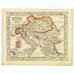
Map of the Austrian Empire, Italian States, Turkey in Europe, and Greece.
A nice example of S. A. Mitchell Jr.'s 1864 map of the Austrian Empire, Italy, Turkey in Europe and Greece. There is an inset in the lower-left corner that features the M...
Date: Philadelphia, 1864
Selling price: ????
Please login to see price!
Sold in 2021

Topographische en militaire kaart van het Koningrijk der Nederlanden / vervaardigd door de officieren van den Generale Staf.
Atlas contains maps of the Kingdom of the Netherlands, executed in lithography, for which the site surveys took place in the years 1852-1854. The maps were made by the of...
Date: 's-Gravenhage, 1864
Selling price: ????
Please login to see price!
Sold
![Illustriss.mo et excell.mo domino domino [...] Viennam Austriae ...](/uploads/cache/46474-250x250.jpg)
Illustriss.mo et excell.mo domino domino [...] Viennam Austriae ...
Rare separately issued circular bird's eye view of Vienna, published by Heinrich Schmidt and Albert Camesina in in Vienna. Showing a rounded view of the area outside of V...
Date: Vienna, 1864
Selling price: ????
Please login to see price!
Sold in 2021
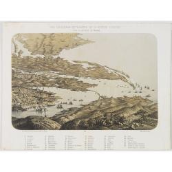
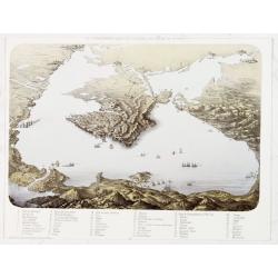
Vue générale du théatre de la guerre d'Orient dans la province de Kerson.
Panoramic View of Nicolaieff and Kerson Bay in the Ukraine. Including a numbered key (1-46) in lower part, mentioning all place names.Published by Wild, rue de la Banque ...
Date: Paris, Wild, c.1865
Selling price: ????
Please login to see price!
Sold in 2010
Vue panoramique du litoral de la Mer Noir.
Panoramic view of the Black Sea with a key 1-53 in lower margin, mentioning all place names.Published by Wild, rue de la Banque 15 près la Bourse, in Paris.
Date: Paris, Wild, c.1865
Selling price: ????
Please login to see price!
Sold in 2013
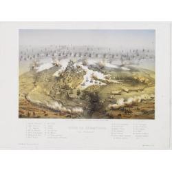
Siège de Sébastopol Vue générale. 2
Panoramic town-plan of the siege of Sebastopol. Chromolithograph after A Cassagne and V. Adam, printed by Lemercier. With a key 1-24 in lower margin.
Date: Paris, Morier, c.1865
Selling price: ????
Please login to see price!
Sold in 2013
Suisse et Nord de l'Italie.
Large and very detailed lithographed map of Switzerland. Includes also Austria until Innsbruck, Italy until Modena, France until Grenoble, and Germany until Munich. V...
Date: Paris, 1865
Selling price: ????
Please login to see price!
Sold in 2013
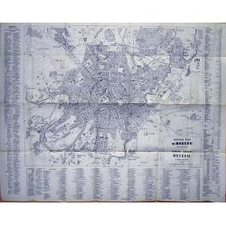
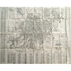
Guide du Voyageur (with rare large plans of Moscow)
French travel guide of St. Petersburg with the large and very rare town-plan of Moscow! "Nouveau Plan de Moscou avec Environs" published by Hoppe in 1867. The ...
Date: Paris, 1866
Selling price: ????
Please login to see price!
Sold in 2012
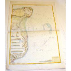
Angleterre Cote S.E., Rade des Dunes.
Informative sea chart featuring the coast of England from Margate to Dover with miniatrure city plans of Deal and Ramsgate in between. Miniature colored pictures of ligh...
Date: Paris, 1866
Selling price: ????
Please login to see price!
Sold in 2015
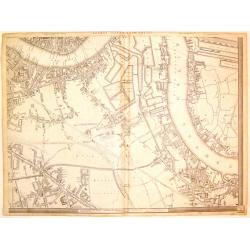
London, (South East Sheet).
Large handsome map of mid-Victorian South East London, including Southwark, Bermonsey, Surrey Docks, Depford and western Isle of Dogs. Published by Cassell, Petter & ...
Date: London, 1866
Selling price: ????
Please login to see price!
Sold in 2019
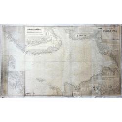
Chart of the North Sea Comprising All the Modern Surveys Drawn by J.S. Hobbs.
A fine antique working nautical chart of the North Sea by Norie, published in London in 1866. It was published by Charles Wilson (Late J.W. Norie and Wilson). The seller...
Date: London, 1866
Selling price: ????
Please login to see price!
Sold in 2018
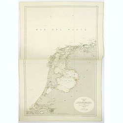
Mar de la Norte, Carta de la Costa de Holanda. . .
A large sea chart, published in Madrid of part of the coast of Holland. The chart extends from Borkum in Lower Saxony in Germany in the north, south to Brouwershaven in Z...
Date: Madrid, 1866
Selling price: ????
Please login to see price!
Sold in 2019
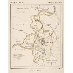
Gemeente Roermond.
From: J.Kuyper Gemeente-Atlas van Nederland naar officieele bronnen bewerkt. He was one of the most important Dutch atlas editors of the second half of the 19th century. ...
Date: Leeuwarden 1867
Selling price: ????
Please login to see price!
Sold in 2025

Plage de Scheveningen.
Attractive lithography showing a typical Dutch beach scene at Scheveningen in the middle of the 19th century, lithographed by Cleman after a painting by Nuyen. Published ...
Date: The Hague, c.1867
Selling price: ????
Please login to see price!
Sold
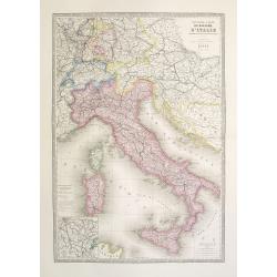
Nouvelle carte du royaume d'Italie indiquant les nouvelles divisions politiques. . . Nouvelle edition.
Large post road maps map of Italy and Central Europe published by A.Logerot. According to a text in lower part "Les eaux gravées à la méganique par M.me Fontaine&...
Date: Paris, c.1867
Selling price: ????
Please login to see price!
Sold in 2023
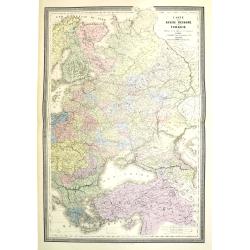
Carte de la Russie d'Europe et de la Turquie Théàtre de la Guerre en Oriens. . .
Very large, highly detailed and uncommon issue of the map by Brué depicting the progress of the war in the Ukraine, the Crimea and the Black Sea. Including Istanbul and ...
Date: Paris, London, ca. 1867
Selling price: ????
Please login to see price!
Sold in 2013
Guide du Voyageur en Russie (with plans of St. Petersburg, Moscow, and a map of Russia)
French travel guide to St. Petersburg with two large and very rare town-plans of St. Petersburg and Moscow! "Nouveau Plan de St. Petersbourg avec Environs" and...
Date: Paris, 1867
Selling price: ????
Please login to see price!
Sold in 2012

Danse Kalmouke sous la tente de la Princesse Tumêne.
Lithography from a rare book by Hommaire-de-Hell "Voyage à la mer Caspienne". Ignace-Xavier Morand Hommaire-de-Hell (1812-1848) was a traveler and geologist, w...
Date: Paris, Lemercier, 1868
Selling price: ????
Please login to see price!
Sold in 2010

Campement de nuit dans les steppes de la mer Caspienne. Voyage à la mer Caspienne par Mr et Mme Hommaire de Hell.
Lithography after a design by Gluck of a Kalmouk Buddhist Temple in the Republic of Kalmykia, the only Buddhist region in Europe. Lithography taken from "Voyage à l...
Date: Paris, Lemercier, 1868
Selling price: ????
Please login to see price!
Sold in 2011

Temple Kalmouk sur la rive gauche du Volga. Voyage à la mer Caspienne par Mr et Mme Hommaire de Hell.
Lithography after a design by Gluck of a Kalmouk Buddhist Temple in the Republic of Kalmykia, the only Buddhist region in Europe. Lithography taken from "Voyage à l...
Date: Paris, Lemercier, 1868
Selling price: ????
Please login to see price!
Sold in 2014
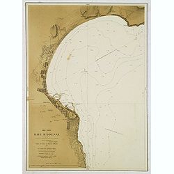
Mer Noire - Baie d'Odessa. . .
Detailed chart of the Bay and town of Odessa in the Ukraine. With soundings. According to the title the chart is copied from a Russian map made by Lieut. Belgavski. The c...
Date: Paris, 1869
Selling price: ????
Please login to see price!
Sold in 2012
Mer Noire. Danube Bouches de la Branche Kilia. / Branche Sulina (Danube).
Two very detailed charts of the outlet of the Danube River into the black Sea. In upper right corner inset map of "Ilan Ada st ou Fido-Nisi ou Ile aux serpents. . . ...
Date: Paris, after 1869
Selling price: ????
Please login to see price!
Sold
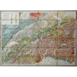
Carte Geologique de la Suisse de M.M.B. Studer et A. Escher von der Linth. 2nd Edition revue et corrigée d'après les publications récentes et les communications des auteurs et de M.M. v. Fritsch, Gilleron, Jaccard, Kaufmann, Mösch, Müller, Stoppani, Théob
Lithographic map, dissected and laid on linen as issued. When folded the map is protected by two contemporary "leather" covers with the title imprinted in gold....
Date: Winterthur, 1869
Selling price: ????
Please login to see price!
Sold in 2020
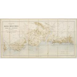
Cartes des Alpes Maritimes Littoral de la Méditerranée aux environs de Fréjus, Cannes, Grasse, Antibes, Nice, Monaco et Menton.
Folding-map of the Maritime Alps and the Mediterranean coastline of Fréjus, Cannes, Grasse, Antibes, Nice, Monaco, and Menton. Engraved by Erhard, geographer and engrave...
Date: Paris, 1870
Selling price: ????
Please login to see price!
Sold in 2008
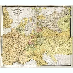
Special-Karte der Eisenbahn- Post- u. Dampfschiff-Verbindungen Mittel-Europa's - mit Angabe aller Eisenbahn-, Post- u. Dampfschiffstationen, Speditionsorte, Zoll- u. Steuerämter, Bäder, Mineralquellen
Gigantic wall map of Central Europe showing rail way, post routes and ship routes, prepared by C.J.C. Raab and edited by H. Müller. More about folding maps. [+]
Date: Glogau, C.Flemming, 1870
Selling price: ????
Please login to see price!
Sold in 2017
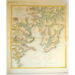
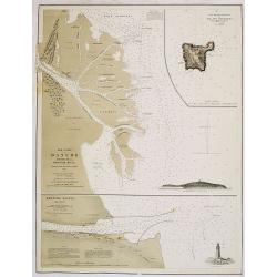
Angleterre Cote Sud, Port du Falmouth.
Striking lithographed sea chart of the Port of Falmouth in England. Depôt des Cartes et Plans de la Marine (1720 - present), often called the Depôt de Marine, was a Fr...
Date: Paris, 1870
Selling price: ????
Please login to see price!
Sold in 2015
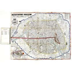
Instantaneous Indicator New Plan of Paris with Ribbon. . .
Instantaneous Indicator New Plan of Paris with Ribbon complete & reetify [sic], for circulating in Paris like the most acquinted [sic] with it, System Acklin, patente...
Date: Paris, Logerot, ca. 1870
Selling price: ????
Please login to see price!
Sold
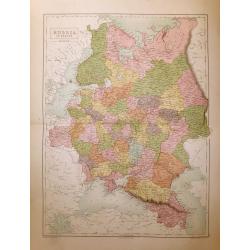
Russia in Europe.
A highly detailed map of Russia in the late 19th century. The provinces are separated by coloring. Published in Edinburgh by Adam & Charles Black
Date: Edinburgh, 1870
Selling price: ????
Please login to see price!
Sold in 2014