Browse Listings in Europe
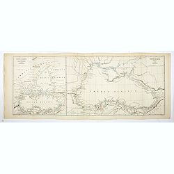
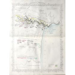
Ponti Euxini Periplus secundum Arrianum.
Two ancient maps on one sheet showing the Black Sea and Ukraine, prepared by Karl Wilhelm Ludwig Muller (1813-1894) and published in "Geographi Graeci Minores"....
Date: Paris, Ambrosio Firmin Didot, 1855
Selling price: ????
Please login to see price!
Sold in 2017
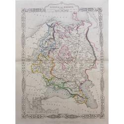
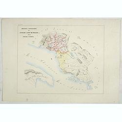
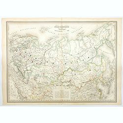
Russia in Europe showing the Territorial Acquisitions since the time of Peter the Great.
"Russia in Europe showing the Territorial Acquisitions since the time of Peter the Great" This map shows the acquisitions from Turkey, Sweden, Poland and Persia...
Date: London, 1855
Selling price: ????
Please login to see price!
Sold in 2019
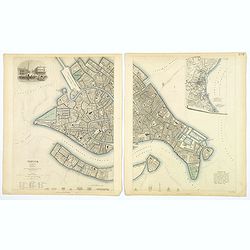
Venice.
A lovely steel engraved plan, on 2 sheets, of Venice by the Society for the Diffusion of Useful Knowledge (SDUK). This English philanthropic enterprise was entirely devot...
Date: London, 1855
Selling price: ????
Please login to see price!
Sold in 2018
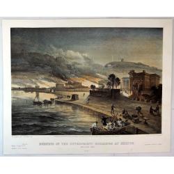
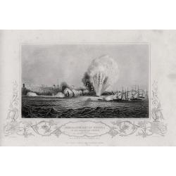
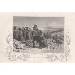
Burning of the Government buildings at Kertch.
A fine hand colored lithograph from "THE SEAT OF WAR IN THE EAST". By the illustrator William Simpson (1823-1899). Published in London in 1855 by Paul and Domin...
Date: London, 1855
Selling price: ????
Please login to see price!
Sold in 2018
Picture map of the Baltic sea.
Large wood block engraved map of the Baltic Sea and adjacent countries (Denmark, Sweden, Finland, Estonia, Latvia, Lithuania, Poland, Germany) with numerous vignettes to ...
Date: London, 1856
Selling price: ????
Please login to see price!
Sold in 2014
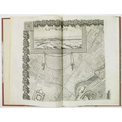
Plan de Paris - Paris
PRINTED ON VELLUM. Large nine panel plan of Paris, if joined height: 52 inches (1321 mm). width: 58 inches (1473 mm). This is the 1856 edition etched by E.Lebel for "...
Date: Paris, Société des Bibliophiles, 1856
Selling price: ????
Please login to see price!
Sold

A set of 15 humorous prints from the Russian Empire's war with the French and British Empire's.
This set of 15 are from 1847 - 1856. Mostly engraved by Joseph Swain. Joseph Swain was one of the most important woodblock engravers. Punch was responsible for the word s...
Date: London 1847 - 1856
Selling price: ????
Please login to see price!
Sold in 2015

A set of 15 humorous prints from the Russian Empire's war with the French and British Empire's.
This set of 15 are from 1846 - 1856. Mostly engraved by Joseph Swain. Joseph Swain was one of the most important woodblock engravers. Punch was responsible for the word s...
Date: London 1846 - 1856
Selling price: ????
Please login to see price!
Sold in 2015

A set of 16 humorous woodblock prints from the Russian Empire's war with the French and British Empire's.
This set of 16 are from 1853 - 1856, mostly engraved by Joseph Swain. Joseph Swain was one of the most important woodblock engravers.Punch was responsible for the word se...
Date: London, 1853 - 1856
Selling price: ????
Please login to see price!
Sold in 2015
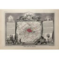
Dépt. De La Seine. - Paris.
A Decorative map of Paris, including the region of Versailles.Beautiful map from one of the finest decorative atlases of the nineteenth century. This attractive map is fr...
Date: Paris, 1856
Selling price: ????
Please login to see price!
Sold in 2017
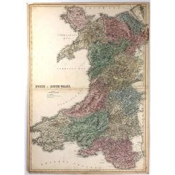
North & South Wales.
This large map is of NORTH & SOUTH WALES. The map is from the 1856 edition of Black's “General Atlas of the World”. The map displays the provinces (of that time) ...
Date: Edinburgh, 1856
Selling price: ????
Please login to see price!
Sold in 2016
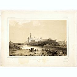
Vue du château de Cracovie, le 17 mars 1840. (Wawel Castle)
Fine depiction of Wawel Castle.Lithographed by Barthélémy Lauvergne and printed by Lemercier. Published by Arthus Bertrand of Paris who worked together with Ackermann i...
Date: Paris, Lemercier, 1852-1856
Selling price: ????
Please login to see price!
Sold in 2021
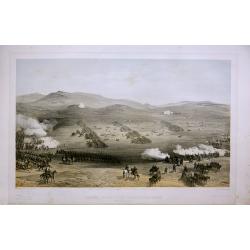
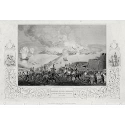
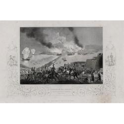
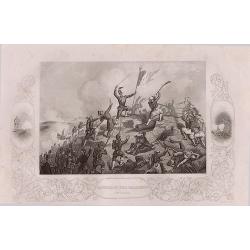
Four lithographic scenes from the Crimean War.
Four lithographic scenes from the Crimean War, based on sketches by William Simpson, which were published in London by Paul and Dominic Colnaghi & Co.- The Charge of ...
Date: London, 1856
Selling price: ????
Please login to see price!
Sold in 2017
A set of 8 maps from The Crimea War.
A set of 8 maps from The Crimea War 1856. By W. & A.K Johnston, published by W & R Chambers London 1856. The titles: 'Portion of The Crimea Forming Chief Scene of...
Date: London, 1856
Selling price: ????
Please login to see price!
Sold in 2016
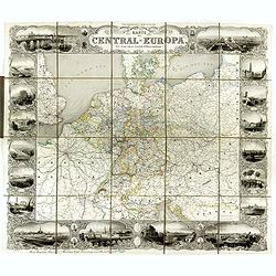
Karte von Central-Europa.
Steel engraved wall map printed from 4 plates by Albert Henry Payne, active in Leipzig and Dresden, dated 1856.Showing The Low Countries, Germany, Prussia, Poland, Denmar...
Date: Leipzig, Dresden, 1856
Selling price: ????
Please login to see price!
Sold in 2018
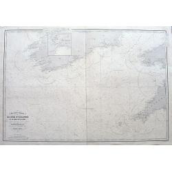
Carte des entrées de la Mer D'Irlande et du Canal de Bristol. . .
A large sea-chart of southern Ireland and parts of Cornwall and Wales. With numerous old pencil notes. colored yellow dots indicate the fire signals along the coasts. Wit...
Date: Paris, 1856
Selling price: ????
Please login to see price!
Sold in 2020

Provincie Limburg
Decorative and uncommon costume plate lithographed by R. de Vries and published by Frans Buffa & Zonen in Amsterdam. Published in Bing, Nederlandsche kleederdragten .
Date: Amsterdam 1857
Selling price: ????
Please login to see price!
Sold
![Environs Of London [. . .] Windsor Castle to Gravesend.](/uploads/cache/92787-250x250.jpg)
Environs Of London [. . .] Windsor Castle to Gravesend.
Engraved by John Dower. An extremely detailed map of the vicinity of London, as it was in 1855 when this map was published. Many vignettes showing scenes in and around Lo...
Date: London, 1857
Selling price: ????
Please login to see price!
Sold in 2014

A set of 16 humorous woodblock prints from the Russian Empire's war with the French and British Empire's.1853 - 1857.
This set of 16 are from This set of 16 are from 1853 - 1857, mostly engraved by Joseph Swain. Joseph Swain was one of the most important woodblock engravers. Punch was re...
Date: London, 1853 -1857
Selling price: ????
Please login to see price!
Sold in 2015
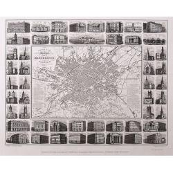
Illustrated Plan of Manchester and Salford.
Uncommon "carte à figures"- city plan of Manchester. Very detailed with street names, and a legend naming 51 buildings with their building date. The map is sur...
Date: Manchester, 1857
Selling price: ????
Please login to see price!
Sold in 2016
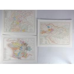
Carte de L'Empire D'Autriche Pour Servir a L'Histoire des Races Bovines (3 Maps.)
An interesting set of three maps showing the species of cow in France, Austria and Germany. Each map has a legend with a color code representing each species. Published b...
Date: Paris, 1857
Selling price: ????
Please login to see price!
Sold in 2019
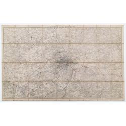
London And Its Environs.
Folding map of London and the surrounding regions. The extents cover the area from Potters Bar down to Epsom and Gravesend across to Windsor. Uncolored except for the pri...
Date: Southampton, 1857
Selling price: ????
Please login to see price!
Sold in 2023
(Crimea) A complete set of 26 engravings depicting The Crimea war, the Battles between the Russian Empire ...
A complete set of 26 engravings depicting The Crimea war, the Battles between the Russian Empire and several European powers for influence over territories of the declini...
Date: London, 1858
Selling price: ????
Please login to see price!
Sold in 2015
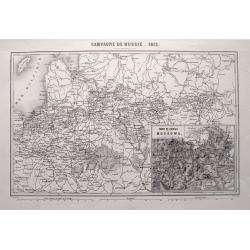
CAMPAGNE DE RUSSIE 1812.
Highly detailed map showing the area from Poland and the Baltics to Moscow, including the cities of Kiev, Minsk, Smolensk, Riga, and many more. An inset map shows the are...
Date: Paris, 1858
Selling price: ????
Please login to see price!
Sold in 2015

A complete set of 30 engravings depicting The Crimea war, the Battles between the Russian Empire and several European powers for influence over territories of the declining Ottoman Empire, Nicholas I. Emperor of Russia and the Military Leaders of the Euro
A complete set of 28 engravings depicting The Crimea war, the Battles between the Russian Empire and several European powers for influence over territories of the declini...
Date: London, 1858
Selling price: ????
Please login to see price!
Sold in 2016
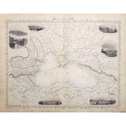
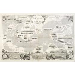
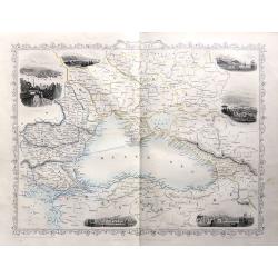
Black Sea.
A highly detailed and decorative map with six vignette illustrations. One of the John Tallis maps published around the time of the Crimea War by The London Printing and P...
Date: London, 1858
Selling price: ????
Please login to see price!
Sold in 2016
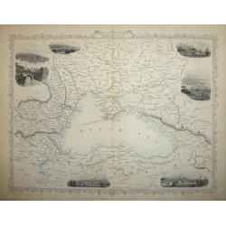
Black Sea
A highly detailed and decorative map of the Black Sea and surrounding areas. The map is enhanced by vignette illustrations of Sebastopol, Varna, Odessa, Sinope, Silistra...
Date: London, 1858
Selling price: ????
Please login to see price!
Sold in 2017
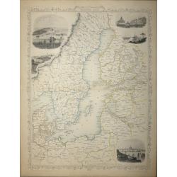
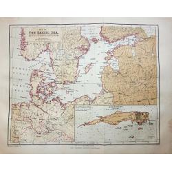
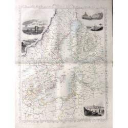
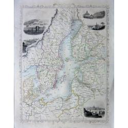
Baltic Sea - John Tallis
A highly detailed and decorative map of the Baltic Sea and surrounding countries with five vignette illustrations.One of the John Tallis maps published around the time of...
Date: London, 1858
Selling price: ????
Please login to see price!
Sold in 2015
(Crimea) A set of 24 engravings depicting The Crimea war, the Battles between the Russian Empire and several European powers for influence over territories of the declining Ottoman Empire.
A set of 24 engravings depicting The Crimea war, the Battles between the Russian Empire and several European powers for influence over territories of the declining Ottoma...
Date: London, 1858
Selling price: ????
Please login to see price!
Sold in 2015
A set of 18 engravings ‘The Crimea War' the Battles between the Russian Empire and the European powers for influence over territories of the declining Ottoman Empire, Nicholas I. Emperor of Russia and the Military Leaders of the European powers.
A collection of 18 steel engravings, depicting The Crimea war, those Battles between the Russian Empire and several European powers for influence over territories of the ...
Date: London, 1858
Selling price: ????
Please login to see price!
Sold in 2016
Baltic Sea - John Tallis
A highly detailed and decorative map of the Baltic Sea and surrounding countries with five vignette illustrations.One of the John Tallis maps published around the time of...
Date: London, 1858
Selling price: ????
Please login to see price!
Sold in 2016
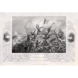
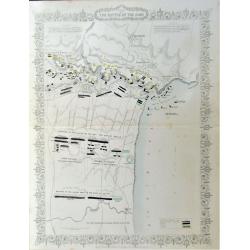
Plan of The Battle of The Alma
A highly detailed battle plan depicting the 'Battle of the Alma River in Crimea', one of the first battles of the Crimean War.The Battle of the Alma was fought September ...
Date: London, 1858
Selling price: ????
Please login to see price!
Sold in 2016
Black Sea
A map of the Black Sea and the surrounding lands, including Turkey, Russia, Georgia, Azerbaijan, Bulgaria, Crimea and Armenia, with six decorative vignettes views of Seba...
Date: London, 1858
Selling price: ????
Please login to see price!
Sold in 2018
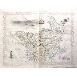
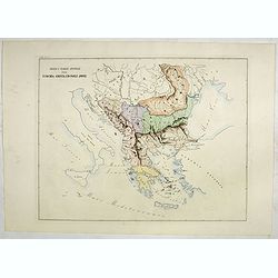
'Turkey in Europe'
A highly decorative and detailed mid-19th century map of 'Turkey in Europe' The Balkans: northern Greece, Macedonia, Bulgaria, Albania, Serbia, Bosnia-Herzogovina, southe...
Date: London, 1858
Selling price: ????
Please login to see price!
Sold in 2016
‘The Crimea War' 18 engravings depicting the Battles between the Russian Empire and the European powers for influence over territories of the declining Ottoman Empire, and the Military Leaders of the European powers.
‘The Crimea War.’ 18 engravings depicting the Battles between the Russian Empire and the European powers for influence over territories of the declining Ottoman Empir...
Date: London, 1858
Selling price: ????
Please login to see price!
Sold in 2016
Baltic Sea
A highly detailed and decorative map of the Baltic Sea and surrounding countries with five vignette illustrations.One of the John Tallis maps published around the time of...
Date: London, 1858
Selling price: ????
Please login to see price!
Sold in 2016
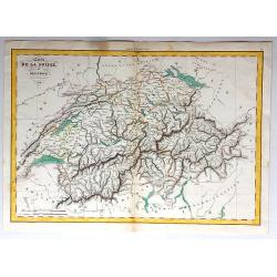
Carte de la Suisse, or Helvetie, par Delamarche, 1858.
Unusual map of Switzerland that has been boldly engraved to feature the remarkable mountainous topography of Switzerland. Charles-François Delamarche (1740 - 1817) was a...
Date: Paris , 1858
Selling price: ????
Please login to see price!
Sold in 2017
20 engravings depicting The Crimea war, the Battles between the Russian Empire and several European powers for influence over territories of the declining Ottoman Empire, Nicholas I. Emperor of Russia and Military Leaders of the European Powers.
An interesting set of 20 engravings depicting The Crimea war, the Battles between the Russian Empire and several European powers for influence over territories of the dec...
Date: London, 1858
Selling price: ????
Please login to see price!
Sold in 2017
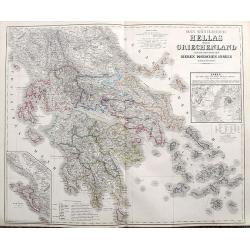
Das Königreich Hellas oder Griechenland und die Republik der sieben Ionischen Inseln (Ephtánisos).
Large and highly detailed map extending from Corfu to Santorini. With Peloponnese, Euboia, Mykonos, Kythira, Zakynthos, and many others. Includes two inset maps of Athens...
Date: Weimar, 1858
Selling price: ????
Please login to see price!
Sold in 2017

Birds Eye View of Berlin in 1858.
An interesting woodblock print of Berlin, dated February 20th, 1858. Published February 20th 1858 in the Illustrated London News.This large bird's eye view of Berlin was ...
Date: London, 1858
Selling price: ????
Please login to see price!
Sold in 2018
A SET OF 20 engravings depicting The Crimea war, the Battles between the Russian Empire and several European powers for influence over territories of the declining Ottoman Empire, Nicholas I. Emperor of Russia and Military Leaders of the European Powers
An interesting set of 20 engravings depicting The Crimea war, the Battles between the Russian Empire and several European powers for influence over territories of the dec...
Date: London, London Printing & Publishing Company, 1858
Selling price: ????
Please login to see price!
Sold in 2020
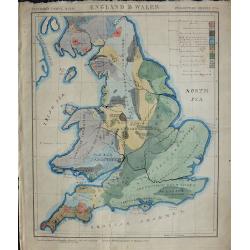
Geological map England & Wales.
An unusual geological map of England and Wales with a key to the colors used. The map is hand drawn and hand colored apart from the title and border, it bears the inscrip...
Date: London, ca. 1858
Selling price: ????
Please login to see price!
Sold in 2018
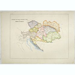
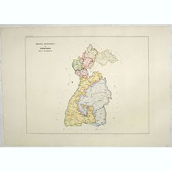
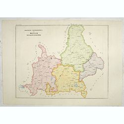
Circoscrizione delle province ecclesiastiche e diocesi nell Impero austriaco (Tav LXIV)
This large-format map of Austria with it different dioceses. The map is finely engraved and beautifully colored and was prepared by Girolamo Petri, a lawyer who served as...
Date: Rome, 1858
Selling price: ????
Please login to see price!
Sold in 2019
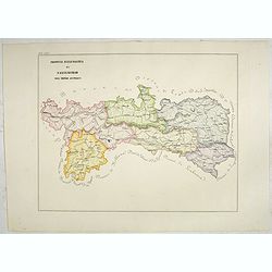
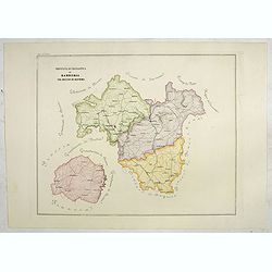
Provincia ecclesiastica di Salisburgo nell' Impero Austriaco (Tav LXVI)
A large-format map of Austria / Salzburg with it different dioceses. The map is finely engraved and beautifully colored and was prepared by Girolamo Petri, a lawyer who s...
Date: Rome, 1858
Selling price: ????
Please login to see price!
Sold in 2019
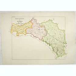
Provincia ecclesiastica di Frigurgo nell' Alemagna (Tav LXXIX)
A large-format map south eastern Germany with Fribourg and its different dioceses. The map is finely engraved and beautifully colored and was prepared by Girolamo Petri, ...
Date: Rome, 1858
Selling price: ????
Please login to see price!
Sold in 2021
Provincia ecclesiastica di Colonia nella Prussia (Tav LXXX)
A large-format map of west Germany and Cologne with its different dioceses. The map is finely engraved and beautifully colored and was prepared by Girolamo Petri, a lawye...
Date: Rome, 1858
Selling price: ????
Please login to see price!
Sold in 2019
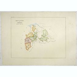
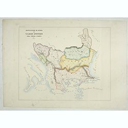
Provincia ecclesiastica di Varsavia nella Polonia Russa (Tav XCI)
A large-format map of Poland / Warsaw with its different dioceses. The map is finely engraved and beautifully colored and was prepared by Girolamo Petri, a lawyer who ser...
Date: Rome, 1858
Selling price: ????
Please login to see price!
Sold in 2023
Diocesi e Vacariati Apostolici della Turchia, Grecia, Ed Isole Jonie (Tav XCIII)
A large-format map of Eastern Europe with its different dioceses. The map is finely engraved and beautifully colored and was prepared by Girolamo Petri, a lawyer who serv...
Date: Rome, 1858
Selling price: ????
Please login to see price!
Sold in 2022
Provincia ecclesiastica di Antivari e arciv di durazzo nella Turchia Europae (Tav XCVII) ( Albania)
This large-format map of Albania with it's different dioceses. The map is finely engraved and beautifully colored and was prepared by Girolamo Petri, a lawyer who served ...
Date: Rome, 1858
Selling price: ????
Please login to see price!
Sold in 2025
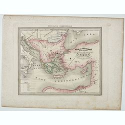
Bacino del Mediterraneo ( Parte orientale) . . .
Uncommon map with the Mediterranean Sea, centered on Greece. With a key to tracks of different streamline routes, prepared by Francesco Costantino Marmocchi. Above the ma...
Date: Genova, Paolo Rivara fu Giacomo, 1858
Selling price: ????
Please login to see price!
Sold in 2021
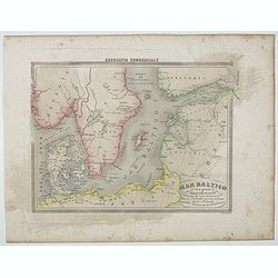
Mar Batilco sur isole e Paesi Circonstanti . . .
Uncommon map of Baltic Sea prepared by Francesco Costantino Marmocchi. Above the map "Geografia Commerciale". From "Il Globo Atlante di carte Geografiche c...
Date: Genova, Paolo Rivara fu Giacomo, 1858
Selling price: ????
Please login to see price!
Sold in 2020

Le Vie Ferrate e le Postali della Francia Meridionale . . .
Uncommon map of South of France and part of Spain prepared by Francesco Costantino Marmocchi. Above the map "Geografia Commerciale". From "Il Globo Atlante...
Date: Genova, Paolo Rivara fu Giacomo, 1858
Selling price: ????
Please login to see price!
Sold in 2020
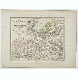
Le Vie Ferrate e le Postali della Francia Settentrionale . . .
Uncommon map of North of France and part of Belgium and England prepared by Francesco Costantino Marmocchi. Above the map "Geografia Commerciale". From "Il...
Date: Genova, Paolo Rivara fu Giacomo, 1858
Selling price: ????
Please login to see price!
Sold in 2020
Le Vie Ferrate e Postali d'Italia . . .
Uncommon map of central Italy and part of Switzerland and France prepared by Francesco Costantino Marmocchi. Above the map "Geografia Commerciale". From "I...
Date: Genova, Paolo Rivara fu Giacomo, 1858
Selling price: ????
Please login to see price!
Sold in 2023
Patriarcati Antichi (Tav II)
This large-format Europe map is finely engraved and beautifully colored and was prepared by Girolamo Petri, a lawyer who served as a senior official within the Vatican’...
Date: Rome, 1858
Selling price: ????
Please login to see price!
Sold in 2020
Province ecclesiastiche di Zagrabia e di Zara nell' Impero Austriaco (Tav LXXIII)
This large-format Zagrabia and Zara map is finely engraved and beautifully colored and was prepared by Girolamo Petri, a lawyer who served as a senior official within the...
Date: Rome, 1858
Selling price: ????
Please login to see price!
Sold in 2020
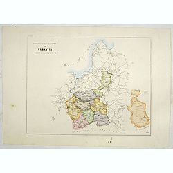
Provincie ecclesiastiche di Leopoli e Fogaras ed Altre Diocesi di Rito Greco (Tav LXXV)
This large-format Romania map is finely engraved and beautifully colored and was prepared by Girolamo Petri, a lawyer who served as a senior official within the Vatican�...
Date: Rome, 1858
Selling price: ????
Please login to see price!
Sold in 2025

Circoscrizione delle province ecclesiastiche Diocesi e missioni nella Germania (Tav LXXVI)
This large-format Germany map is finely engraved and beautifully colored and was prepared by Girolamo Petri, a lawyer who served as a senior official within the Vatican�...
Date: Rome, 1858
Selling price: ????
Please login to see price!
Sold in 2021
Province ecclesiastica di Monaco nel regno di Baviera (Tav LXXVII)
This large area of southern Germany, centered on Regensburg and western Austria, with the tip of Lake Constance to the left.The map is finely engraved and beautifully col...
Date: Rome, 1858
Selling price: ????
Please login to see price!
Sold in 2021
Provincia ecclesiastica di Bamberga nel regno di Baviera (Tav LXXVIII)
This large-format Bamberg map is finely engraved and beautifully colored and was prepared by Girolamo Petri, a lawyer who served as a senior official within the Vatican�...
Date: Rome, 1858
Selling price: ????
Please login to see price!
Sold in 2020
Provincia ecclesiastica di Leopoli rito latino nell' Impero Austriaco (Tav LXXIV)
This large-format south Poland map is finely engraved and beautifully colored and was prepared by Girolamo Petri, a lawyer who served as a senior official within the Vati...
Date: Rome, 1858
Selling price: ????
Please login to see price!
Sold in 2021
Arcivescovato di Scopia e vicariati Apostolici nella Turchia Europea. (Tav XCVIII)
This large-format map of Eastern Europe, including Bosnia, Herzegovina, Albania, Montenegro, Servia, Bulgaria, Romania and Molavia. The map is finely engraved and beautif...
Date: Rome, 1858
Selling price: ????
Please login to see price!
Sold in 2025
Russie Europeenne et Asiatique.
A large detailed map of the entirety of the Russian Empire, as it was under Czar Alexander II in the middle of the nineteenth century. Also shown as part of the map are F...
Date: Paris, 1858
Selling price: ????
Please login to see price!
Sold in 2020
Plan of the Battle of the Alma.
A detailed steel engraved map of the Battle of Alma The map includes a hand colored key as to the positions of the English, French, Turks, and Russians. Inscription: Draw...
Date: London, 1858
Selling price: ????
Please login to see price!
Sold in 2020
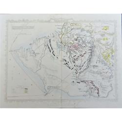
Siege of Sebastopol.
A detailed steel engraved map of Sebastopol. The map includes a hand colored key as to the positions of the English, French, Turks, Russians, and Sardinians. Dates and po...
Date: London, 1858
Selling price: ????
Please login to see price!
Sold in 2020

Palais Pitti à Florens.
Uncommon and decorative lithography of Pitti Palace, with in background a view of he dome of the cathedral (Duomo) of Florence, published by Carl Johan Billmark and print...
Date: Paris, c.1859
Selling price: ????
Please login to see price!
Sold in 2020

Ponte Corvo - Etats Romains.
Uncommon and decorative lithography published by Carl Johan Billmark and printed by Lemercier in Paris, 55 rue de Seine, the leading firm in Europe at that time. From: It...
Date: Paris, c.1859
Selling price: ????
Please login to see price!
Sold in 2012
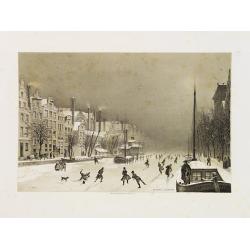
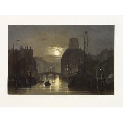
Le Rokin à Amsterdam.
Uncommon and decorative lithography of a froozen channel Rokin in Amsterdam, published by Carl Johan Billmark and printed by Lemercier in Paris, 55 rue de Seine, the lead...
Date: Paris, c.1859
Selling price: ????
Please login to see price!
Sold
![La Tour de Jean Rumpelman à Amsterdam. [Montelbaanstoren]](/uploads/cache/22081-250x250.jpg)
La Tour de Jean Rumpelman à Amsterdam. [Montelbaanstoren]
Uncommon and decorative lithography of the Montelbaanstoren in Amsterdam, published by Carl Johan Billmark and printed by Lemercier in Paris, 55 rue de Seine, the leading...
Date: Paris, c.1859
Selling price: ????
Please login to see price!
Sold in 2020

Château de Heidelberg.
Uncommon and decorative lithography published by Carl Johan Billmark and printed by Lemercier in Paris, 55 rue de Seine, the leading firm in Europe at that time. From: It...
Date: Paris, c.1859
Selling price: ????
Please login to see price!
Sold in 2015
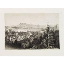
Lucerne.
Uncommon and decorative lithography of Lucerne, published by Carl Johan Billmark and printed by Lemercier in Paris, 55 rue de Seine, the leading firm in Europe at that ti...
Date: Paris, c.1859
Selling price: ????
Please login to see price!
Sold

Cascade de Handeck.
Uncommon and decorative lithography published by Carl Johan Billmark and printed by Lemercier in Paris, 55 rue de Seine, the leading firm in Europe at that time. From: It...
Date: Paris, c.1859
Selling price: ????
Please login to see price!
Sold

Vallée d'Interlacken.
Uncommon and decorative lithography published by Carl Johan Billmark and printed by Lemercier in Paris, 55 rue de Seine, the leading firm in Europe at that time. From: It...
Date: Paris, c.1859
Selling price: ????
Please login to see price!
Sold

Fribourg.
Uncommon and decorative lithography of Freiburg, published by Carl Johan Billmark and printed by Lemercier in Paris, 55 rue de Seine, the leading firm in Europe. From: It...
Date: Paris, c.1859
Selling price: ????
Please login to see price!
Sold
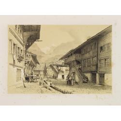
Rue à Meyringen, Vallée de Hasli.
Uncommon and decorative lithography published by Carl Johan Billmark and printed by Lemercier in Paris, 55 rue de Seine, the leading firm in Europe at that time. From: It...
Date: Paris, c.1859
Selling price: ????
Please login to see price!
Sold in 2015

Auberge sur le Wengern-Alp.
Uncommon and decorative lithography published by Carl Johan Billmark and printed by Lemercier in Paris, 55 rue de Seine, the leading firm in Europe at that time. From: It...
Date: Paris, c.1859
Selling price: ????
Please login to see price!
Sold in 2014

Sion.
Uncommon and decorative lithography published by Carl Johan Billmark and printed by Lemercier in Paris, 55 rue de Seine, the leading firm in Europe at that time. From: It...
Date: Paris, c.1859
Selling price: ????
Please login to see price!
Sold in 2014
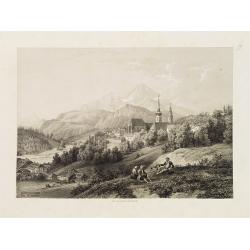
Berchtesgaden (Près de Salzbourg).
Uncommon and decorative lithography published by Carl Johan Billmark and printed by Lemercier in Paris, 55 rue de Seine, the leading firm in Europe at that time. From: It...
Date: Paris, c.1859
Selling price: ????
Please login to see price!
Sold in 2017
Rotterdam.
Uncommon and decorative lithography of Rotterdam, published by Carl Johan Billmark and printed by Lemercier in Paris, 55 rue de Seine, the leading firm in Europe at that ...
Date: Paris, c.1859
Selling price: ????
Please login to see price!
Sold in 2009

Zaandam.
Uncommon and decorative lithography of windmills around Zaandam, published by Carl Johan Billmark and printed by Lemercier in Paris, 55 rue de Seine, the leading firm in ...
Date: Paris, c.1859
Selling price: ????
Please login to see price!
Sold in 2009