Browse Listings in Europe
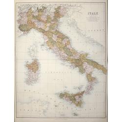
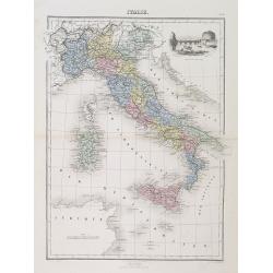
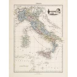
Italy with Sicily, Corsica, Malta, and Sardinia.
A highly detailed map of Italy with Sicily, Corsica, Malta and Sardinia by John Bartholomew Provinces are divided by colors.Published in Edinburgh by Adam & Charles B...
Date: Edinburgh 1870
Selling price: ????
Please login to see price!
Sold in 2014

Suspension Bridge, Russia, Across the Dnieper at Kieff.
Fine lithograph of the wrought iron bar-chain suspension bridge erected by command of the Emperor of Russia. Currently, the bridge is in Kiev, Ukraine.
Date: 1870
Selling price: ????
Please login to see price!
Sold in 2015
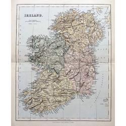
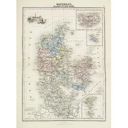
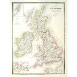
Ireland.
A highly detailed map of the island. Names many towns, areas, rivers, lochs, bays, railways etc.
Date: London, Edingburgh & Glasgow, ca. 1870
Selling price: ????
Please login to see price!
Sold in 2018

Temple d'Antonin et Faustine / Tempio d'Antonino e Faustina.
A nice and decorative lithograph from Rome dans sa Grandeur.
Date: Paris, ca 1870
Selling price: ????
Please login to see price!
Sold in 2019
![Karta Kievskoi Gubernii [Kiev Governorate, Ukraine].](/uploads/cache/34757-250x250.jpg)
Karta Kievskoi Gubernii [Kiev Governorate, Ukraine].
A detailed map of Ukraine's Kyiv Governorate, printed in St. Petersburg by Alexey Afinogenovich Ilyin, one of the most important 19th Century maps of the region.This fine...
Date: St. Petersburg, 1871
Selling price: ????
Please login to see price!
Sold in 2021

La Canonnière la Farcy amarrée en face des Tuileries pendante l'incendie de Paris dans la nuit du 24 Mai 1871.
Very fine lithography in decorative original hand color of the Palais des Tuileries set on fire in the last days of the Paris Commune, either by Communards or by petrol b...
Date: Paris, F. Sinnett, 1871
Selling price: ????
Please login to see price!
Sold
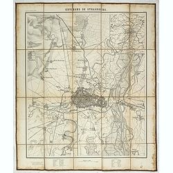
Environs de Strasbourg.
Map of Strasbourg and its direct vincinity, prepared by the Historical Section of the Major General Prussian State, map at 1 / 25,000. Published by E.S. Mittler and Sons,...
Date: Berlin, 1871
Selling price: ????
Please login to see price!
Sold in 2020
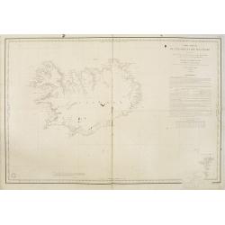
Carte réduite de l'Islande et des Iles Feroë. . . N°837.
Sea of Iceland and the Faroes Islands.Lighthouses are colored by hand in red and yellow. It shows soundings, anchorage's, channels, shoals, navigational sightings.
Date: Paris, 1872
Selling price: ????
Please login to see price!
Sold in 2015
![[Tittle in Russian] Kapta. . . (Map of the Russian North Coast).](/uploads/cache/29142-250x250.jpg)
[Tittle in Russian] Kapta. . . (Map of the Russian North Coast).
A detailed wall map sized map of the Northern coast of Russia with a color key in top which seems to highlight the various Russian Artic explorations along the coast usin...
Date: Moscow, 1872
Selling price: ????
Please login to see price!
Sold in 2014
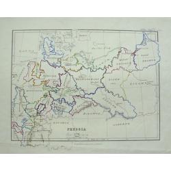
Prussia.
Detailed map of Germany, Prussia and Poland, with unique hand-drawn details and borders. Dated 1872 by Alice Welsh. Includes several kingdoms, rivers, and cities.
Date: London, 1872
Selling price: ????
Please login to see price!
Sold in 2015
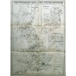
The Newspaper Map of the United Kingdom.
Large map, showing the distribution and variety of newspaper publication in the UK. A key has symbols that give an explanation of towns with one paper, more than one pape...
Date: London, 1872
Selling price: ????
Please login to see price!
Sold in 2015
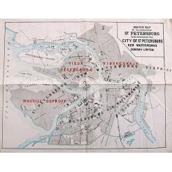
Sketch Map of the Districts of St. Petersburg to be supplied by the City of St. Petersburg New Waterworks Company Limited.
A scarce plan of St. Petersburg. The names of the districts to be "newly" supplied with water - "Vieux Petersburg" (Peterburgskaya), "Viborgskaya...
Date: St. Petersburg, 1873
Selling price: ????
Please login to see price!
Sold in 2017
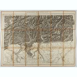
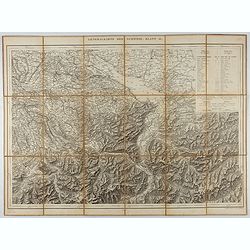
Generalkarte der Schweiz. Blatt IV.
Folding map showing the area from Mainz in the north to Bergamo and Como in the south. The map, engraved by Müllhaupt, is probably part of the 'Topographical Atlas of th...
Date: Bern, 1873
Selling price: ????
Please login to see price!
Sold in 2023
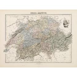
Suisse ou Helvétie.
Decorative map of Switzerland from Géographie Universelle, Atlas Migeon. published by J. Migeon. Very nice engraving of view of the Chapel of Willem Tell. Engraving by S...
Date: Paris, 1874
Selling price: ????
Please login to see price!
Sold in 2011
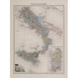
Italie Méridionale.
Decorative map of Italy from Géographie Universelle, Atlas Migeon. published by J. Migeon. Engraved by L.Smith. Inset of the Isle of Sardine.From one of the last decorat...
Date: Paris, 1874
Selling price: ????
Please login to see price!
Sold in 2019
Italie Ancienne.
Decorative map of Italy from Géographie Universelle, Atlas Migeon. published by J. Migeon. In upper right hand corner a view of the "Temple de la Sibylle a Tivoli&q...
Date: Paris, 1874
Selling price: ????
Please login to see price!
Sold in 2017
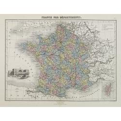
France par Départements.
Decorative map of France from Géographie Universelle, Atlas Migeon. published by J. Migeon. In lower left hand corner a view of a building in Strasbourg engraved by Schr...
Date: Paris 1874
Selling price: ????
Please login to see price!
Sold
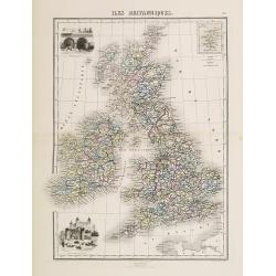
Iles Britanniques.
Decorative map of the British Isles from Géographie Universelle, Atlas Migeon. published by J. Migeon. In lower left hand corner a view of the tower of London and an eng...
Date: Paris 1874
Selling price: ????
Please login to see price!
Sold
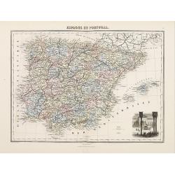
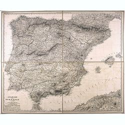
Espagne et Portugal
Decorative map of Spain and Portugal from Géographie Universelle, Atlas Migeon. published by J. Migeon. In lower right hand corner a view of Alhambra engraved by Schroed...
Date: Paris 1874
Selling price: ????
Please login to see price!
Sold
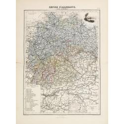
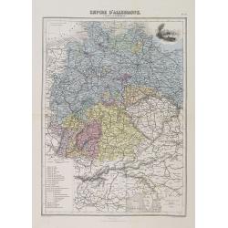
Empire d'Allemange.
Decorative map of the Germany from Géographie Universelle, Atlas Migeon. published by J. Migeon. Engraving by Schroeder of a view of Mayence in the upper right corner.Fr...
Date: Paris 1874
Selling price: ????
Please login to see price!
Sold
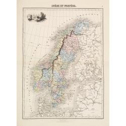
Suède et Norvége.
Decorative map of the Sweden and Norway from Géographie Universelle, Atlas Migeon. published by J. Migeon. Engraving by Schroeder of a view of the Stockholm in the upper...
Date: Paris 1874
Selling price: ????
Please login to see price!
Sold
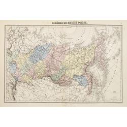
Sibérie ou Russie d'Asie.
Decorative map of Russia from Géographie Universelle, Atlas Migeon. published by J. Migeon. From one of the last decorative atlases published in the 19th centu...
Date: Paris, 1874
Selling price: ????
Please login to see price!
Sold in 2009
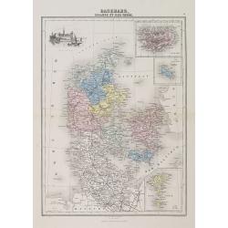
Danemark
Decorative map of the Denmark from Géographie Universelle, Atlas Migeon. published by J. Migeon. Engraved by Schroeder of a view of the castle of Kroneburg in the upper ...
Date: Paris, 1874
Selling price: ????
Please login to see price!
Sold in 2019
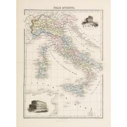
Italie.
Decorative map of Italy from Géographie Universelle, Atlas Migeon, published by J. Migeon. In upper right hand corner a view of the Saint Angu castle in Rome engraved by...
Date: Paris, 1874
Selling price: ????
Please login to see price!
Sold in 2017
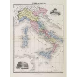
Italie Ancienne.
A decorative map of Ancient Italy from Géographie Universelle, Atlas Migeon. With an engraving of the Coliseum in Rome lower left corner. A second engraving of the Templ...
Date: Paris, 1874
Selling price: ????
Please login to see price!
Sold in 2019
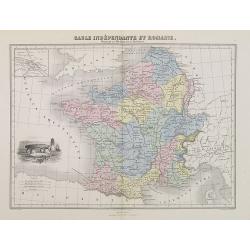
Gaule Indépendante et Romaine.
A decorative map of Ancient France from Géographie Universelle, Atlas Migeon. With an engraving of a Dolmen menhir lower left corner and an inset map of Lutecia (Paris) ...
Date: Paris, 1874
Selling price: ????
Please login to see price!
Sold
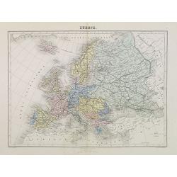
Europe.
A decorative map of Europe from Géographie Universelle, Atlas Migeon, published by J. Migeon.From one of the last decorative atlases published in the 19th century.
Date: Paris, 1874
Selling price: ????
Please login to see price!
Sold in 2012
France en 1789 donnant la comparaison immédiate des anciennes Provinces et des Départements actuels.
A thematic showing France in 1789 with its "departments" from Géographie Universelle, Atlas Migeon. With an engraving of the Bastille fortress in 1789 in the l...
Date: Paris, 1874
Selling price: ????
Please login to see price!
Sold in 2010
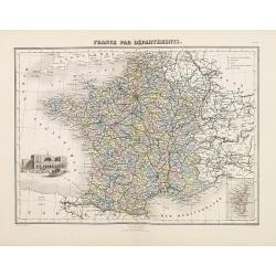
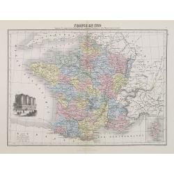
France par Départements.
A decorative map of France divided in its departments from Géographie Universelle, Atlas Migeon. With an engraving of Strasbourg's Rail Road Station in the lower left co...
Date: Paris, 1874
Selling price: ????
Please login to see price!
Sold in 2017
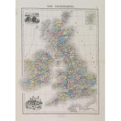
Iles Britanniques.
A decorative map of England, Wales, Scotland, and Ireland from Géographie Universelle, Atlas Migeon. An engraving of the XVIth century London Tower in the lower-left cor...
Date: Paris, 1874
Selling price: ????
Please login to see price!
Sold in 2015
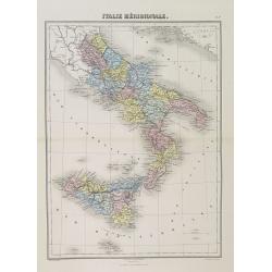
Italie Méridionale.
A decorative map of southern Italy including Sicily from Géographie Universelle, Atlas Migeon published by J. Migeon. From one of the last decorative atlases published i...
Date: Paris, 1874
Selling price: ????
Please login to see price!
Sold in 2022
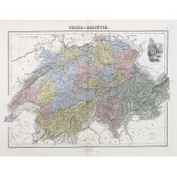
Suisse ou Helvétie.
A decorative map of Switzerland from Géographie Universelle, Atlas Migeon, published by J. Migeon. With an engraving of William Tell's Chapel in the upper right corner. ...
Date: Paris, 1874
Selling price: ????
Please login to see price!
Sold in 2012
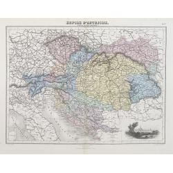
Empire d'Autriche (Empire Autro-Hongrois).
A decorative map of Austria and Hungary from Géographie Universelle, Atlas Migeon, published by J. Migeon. With an engraving of Vienna lower right corner.From one of the...
Date: Paris, 1874
Selling price: ????
Please login to see price!
Sold in 2012
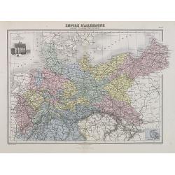
Empire d'Allemagne (Carte d'ensemble).
A decorative map of Germany from Géographie Universelle, Atlas Migeon, published by J. Migeon. With an engraving of Mainz in upper right corner.From one of the last deco...
Date: Paris, 1874
Selling price: ????
Please login to see price!
Sold in 2018
Empire d'Allemagne (Prusse et autres Etats du Nord).
A decorative map of the German Empire with Prussia and other northern States from Géographie Universelle, Atlas Migeon, published by J. Migeon. With an engraving of the ...
Date: Paris, 1874
Selling price: ????
Please login to see price!
Sold in 2009
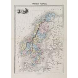
Suède et Norvège.
A decorative map of Sweden and Norway from Géographie Universelle, Atlas Migeon, published by J. Migeon. With an engraving of Stockholm upper left corner.From one of the...
Date: Paris, 1874
Selling price: ????
Please login to see price!
Sold in 2012
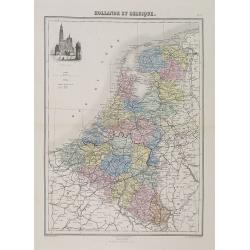
Hollande et Belgique.
A decorative map of Holland and Belgium from Géographie Universelle, Atlas Migeon, published by J. Migeon. With an engraving of the Antwerp Cathedral upper left corner.F...
Date: Paris, 1874
Selling price: ????
Please login to see price!
Sold in 2011
Danemark, Islande et Iles Faeröe.
A decorative map of Denmark, Iceland and the Faroe Islands from Géographie Universelle, Atlas Migeon. published by J. Migeon. With an engraving of the Kronborgh Castle u...
Date: Paris, 1874
Selling price: ????
Please login to see price!
Sold in 2013
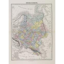
Russie d'Europe.
A decorative map of Russia from Géographie Universelle, Atlas Migeon, published by J. Migeon.From one of the last decorative atlases published in the 19th century.
Date: Paris, 1874
Selling price: ????
Please login to see price!
Sold in 2014
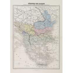
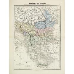
Péninsule des Balkans. Turquie -Roumanie - Serbie -Bulgarie - Bosnie - Monténégro.
A decorative map of the Balkan States (Romania, Serbia, Bulgaria, Bosnia and Montenegro) from Géographie Universelle, Atlas Migeon, published by J. Migeon.From one of th...
Date: Paris, 1874
Selling price: ????
Please login to see price!
Sold in 2010
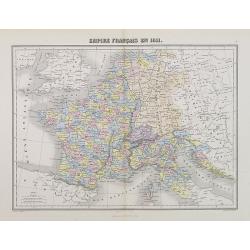
Empire Français en 1811.
A decorative map of the French Empire in 1811 from Géographie Universelle, Atlas Migeon. published by J. Migeon.From one of the last decorative atlases published in the ...
Date: Paris, 1874
Selling price: ????
Please login to see price!
Sold
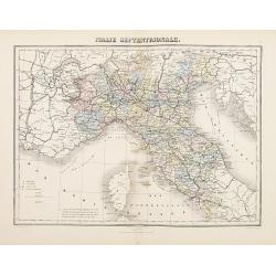
Italie Septentrionale
Decorative map of Italy from Géographie Universelle, Atlas Migeon. published by J. Migeon. From one of the last decorative atlases published in the 19th century.
Date: Paris, 1874
Selling price: ????
Please login to see price!
Sold in 2022
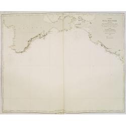
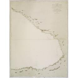
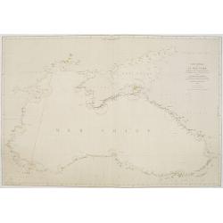
Carte de la Mer Noire. (3e Feuille). Du Cap Chersonèse à la pointe Chardak.
Very detailed chart of the Black Sea with the entry to the Sea of Azof. including the towns of Kerch, Sevastopol, etc. Showing soundings in meters, lighthouses are marked...
Date: Paris, 1860 updated to 1874
Selling price: ????
Please login to see price!
Sold in 2012
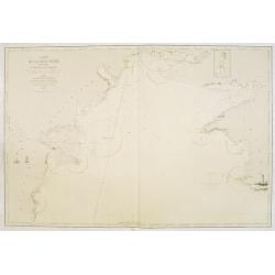
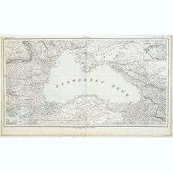
Carte de la Mer Noire. (2e Feuille). De Mangalia au Cap Chersonèse.
Very detailed chart of the Black Sea including the towns of Odessa, Sevastopol, etc. In the upper right corner small inset map of the Dniprov River up to Nikolaef. Showin...
Date: Paris, 1860 updated for 1874
Selling price: ????
Please login to see price!
Sold in 2012
Pèninsule des Balkans.
Decorative map of the Balkan from Géographie Universelle, Atlas Migeon. published by J. Migeon. From one of the last decorative atlases published in the 19th century.
Date: Paris, 1874
Selling price: ????
Please login to see price!
Sold in 2017
![[Tittle in Russian] Kapta...(Taymyr Peninsula)](/uploads/cache/29138-250x250.jpg)
[Tittle in Russian] Kapta...(Taymyr Peninsula)
Chart of the Russian peninsula of Taymyr in Northern Russia. Lithograph, in two sheets joined as one. This map in great detail appears to be a Russian government chart. I...
Date: Moscow, 1874
Selling price: ????
Please login to see price!
Sold in 2014
Plan général des environs de Sébastopol avec indication de la disposition générale de l'armée alliée au 24 octobre / 5 novembre 1854 et du mouvement du prince Gortchakow vers le mont Sapoune.
A very rare panoramic town-plan of the siege of Sebastopol. In lower margin : "Gravé au Dépôt topographique de la Guerre". From "Défense de Sébastopol...
Date: Saint-Pétersbourg / Paris, 1863-1874
Selling price: ????
Please login to see price!
Sold in 2014
Italie.
Decorative map of Italy from Géographie Universelle, Atlas Migeon. published by J. Migeon. In upper right hand corner a view of the Saint Angu castle in Rome engraved by...
Date: Paris, 1874
Selling price: ????
Please login to see price!
Sold in 2018
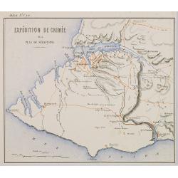
Expédition de Crimée. 1854 Plan de Sébastopol.
Map of Krim area centered on Sebastopol and showing in red the French expedition of 1854. Published in \"Atlas de Géographie Militaire adopté par M. le min. de la ...
Date: Paris, Furne, Jouvet et Cie, 1875
Selling price: ????
Please login to see price!
Sold in 2009
Carte physique et politique des iles britanniques.
Very large, highly detailed and uncommon map of the British Isles, with inset map of the world and the Shetland Islands. The map shows according to the title: main interr...
Date: Paris, 1875
Selling price: ????
Please login to see price!
Sold in 2010
Carte de la Mer Noire. (4e Feuille). Du Cap Idokopas au Cap Zefiros.
Very detailed chart of the eastern part of the Black Sea with the coast of Georgia, including the towns of Lidzava, Anaklia, Poti, Supsa, Kobuleti. Showing soundings in m...
Date: Paris, 1860 updated to 1875
Selling price: ????
Please login to see price!
Sold in 2013

Venice. (Lot of 3 engravings)
Three fine steel engravings featuring canal scenes in Venice, Italy. They are entitled: "VENICE", "APPROACH TO VENICE" & "THE GRAND CANAL VEN...
Date: New York, 1875
Selling price: ????
Please login to see price!
Sold in 2015

Caligula's Palace and Bridge.
Fine hand-colored steel engraving by E. Goodall from a painting by the renowned J.M.W. Turner. It was published in 1875 by Appleton in New York. The engraving features &...
Date: New York, 1875
Selling price: ????
Please login to see price!
Sold in 2015
Spanien und Portugal.
Very detailed folding map of Spain and Portugal, by Vogel, C.
Date: 1875
Selling price: ????
Please login to see price!
Sold in 2021
Generalkarte der Schweiz. Blatt II.
Folding map showing Lake Constance and surroundings. The map, engraved by Müllhaupt, is probably part of the 'Topographical Atlas of the Federal General Staff reduced un...
Date: Bern, 1875
Selling price: ????
Please login to see price!
Sold in 2021
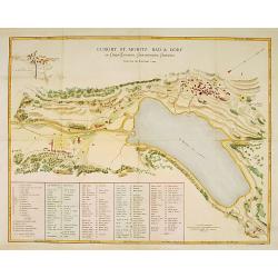
Curort St.Moritz Bad & Dorf in Ober-Engadin. . .
A detailed plan of St.Moritz, with extensive key to the principal places of interest.
Date: Zürich 1876
Selling price: ????
Please login to see price!
Sold
Carte générale de la Mer Noire Dressée d'après les travaux russes . . .
Chart of the Black Sea, with latitude and longitude scales, villages, banks and soundings in fathoms. Lighthouses highlighted in yellow and red.A line in red pen and ink ...
Date: Paris, 1860 with updates for 1868 - 1876
Selling price: ????
Please login to see price!
Sold in 2011
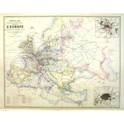
Nouvelle carte des voies de communication de l'Europe par des chemins de fer et la Navigation maritime.
Uncommon map of Europe showing the rail way system, steamboat routes connecting the European cities. Inset maps of London and Paris and a color key in lower left. Publish...
Date: Paris, 1876
Selling price: ????
Please login to see price!
Sold in 2011
Schwarzes Meer Nr 1
Uncommon map of the Black Sea and Crimea. In lower part a scale. Prepared by F.Handtke
Date: Glogau, Leipzig, 1877
Selling price: ????
Please login to see price!
Sold in 2011

Impressioni al Bagno. Papagallo No. 28. Anno V.
Showing a Russian preventing an English figure leaving the sea by pulling a sharp of John Bull. Italian, American, Indian, Istanbul representations in the sea. Taken from...
Date: Bologne, 1877
Selling price: ????
Please login to see price!
Sold in 2018

Il colosso di Rodi. Papagallo No. 41. Anno V.
Satirical plate published in the supplement to the political newspaper charivaric Papagallo / Le Perroquet N. 41, in the 5th year of publication, published in Bologna. Th...
Date: Bologne, 1877
Selling price: ????
Please login to see price!
Sold
![Die Ethnographie Russland's. [With two maps]](/uploads/cache/32955-250x250.jpg)
Die Ethnographie Russland's. [With two maps]
A 43 pages ethnographical description of Russia by A. F. Rittich. Including chapters on : Die Kaukasus-Völker - Hyperboreer oder Arktiker - Die Völker der Mongolischen ...
Date: Gotha, Perthes, 1878
Selling price: ????
Please login to see price!
Sold in 2012
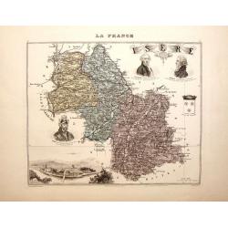
La France - Isere.
Nice decorated hand colored map of the Isere department of France. There are five cartouches including portraits of Vaucanson, Barnave & Bayart, the city of Grenoble ...
Date: Paris, 1878
Selling price: ????
Please login to see price!
Sold in 2014

Wandkarte des Deutsches Reiches zum Schul und Comptoir-Gebrauch. . .
School wall map of Germany, Poland, Low Counties, Bohemia printed in chromo lithography with contemporary hand coloring to borders. Published by "Stich und Druck der...
Date: Berlin, Dieter Reimer, 1878
Selling price: ????
Please login to see price!
Sold in 2024

A set of 16 humorous prints of Russian interest and The Russian Empire's Crimea war with the French and British Empire's.
This set of 16 are from 1853 - 1878. Mostly engraved by Joseph Swain. Joseph Swain was one of the most important woodblock engravers. Punch was responsible for the word s...
Date: London 1853 – 1878
Selling price: ????
Please login to see price!
Sold in 2016

A set of 20 humorous prints of Russian interest and The Russian Empire's Crimea war with the French and British Empire's 1853 - 1878
This set of 20 are from 1853 - 1878. Mostly engraved by Joseph Swain. Joseph Swain was one of the most important woodblock engravers. Punch was responsible for the word s...
Date: London, 1853 - 1878
Selling price: ????
Please login to see price!
Sold in 2016

A set of 20 humorous prints from the Russian Empire's war with the French and British Empire's.
This set of 20 are dated from 1853 - 1878. Mostly engraved by Joseph Swain. Joseph Swain was one of the most important woodblock engravers. Punch was responsible for the ...
Date: London 1853 - 1878
Selling price: ????
Please login to see price!
Sold in 2016

Un Temporale terribile. Papagallo No. 2. Anno VI.
Showing an English figure standing on British and American soil. Design by Augusto Grossi. Taken from the Italian satirical newspaper Il Papagallo, a satirical magazine f...
Date: Bologne, 1878
Selling price: ????
Please login to see price!
Sold in 2019
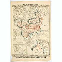
Map of Turkey in Europe. Illustrating the Berlin CongressTtreaty, July 1878.
An unusual map of Turkey, Greece, the Balkans, Austria and a part of the Ukraine, illustrating the nations created under the Berlin Congress Treaty, as well as the lands ...
Date: Philadelphia, 1878
Selling price: ????
Please login to see price!
Sold in 2021
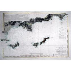
Carte particulière des cotes de France Dept. du Var...
Very large sea chart of a part of the Provence - Côte d'Azur region. From Hyères to Cap Camarat. Includes Ile de Porquerolles, Port-Cros, Ile du Levant. Dated 1843 but ...
Date: Paris, 1879
Selling price: ????
Please login to see price!
Sold in 2016

Cathédrale des Patriarches, (Saints Apôtres) intérieur du Kremlin.
Beautiful lithography of the Cathédrale des Patriarches in Kremlin, Moscow.
Date: Paris, ca. 1880
Selling price: ????
Please login to see price!
Sold in 2009
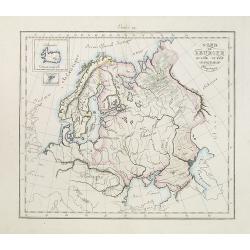
Nord de l'Europe Russie Suède -Denemach- Physique. Etude 19.
Map of the North of Europe including Russia, Sweden and Denmark with two inset maps of Island and the Danish Faeroe Islands.
Date: Paris, c. 1880
Selling price: ????
Please login to see price!
Sold in 2010
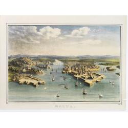
Malta.
A bird's eye view of Malta with many ships entering the port.
Date: c.1880
Selling price: ????
Please login to see price!
Sold in 2012

(Russia)
This color lithography carries in the upper left corner a map of European Russia with several towns mentioned. In the center a child and further decorated with flag, coat...
Date: c. 1880
Selling price: ????
Please login to see price!
Sold in 2012
![Portrait de la Ville, Cité et Université de Paris avec les Faubourgs di celle dédié au Roy. [photogravure facsimile from 1880]](/uploads/cache/32083-250x250.jpg)
Portrait de la Ville, Cité et Université de Paris avec les Faubourgs di celle dédié au Roy. [photogravure facsimile from 1880]
This very fine photogravure plate is showing Paris at medieval times after Nicolay. This late 19th century and slightly reduced facsimile of this famous and very rare pla...
Date: Paris, c.1880
Selling price: ????
Please login to see price!
Sold
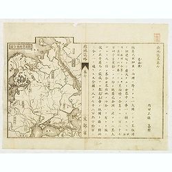
Japanese map of Central part of Europe with Black Sea and Ukraine.
Japanese map of Central part of Europe with Black Sea and Ukraine, with a description to the right.
Date: Japan, ca. 1880
Selling price: ????
Please login to see price!
Sold in 2012
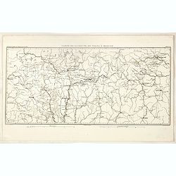
Carte de la Route de Wilna à Moscou.
Detailed road map of the European part of Russia, centered on Minsk, Smolensk and Moscow in the upper right corner, prepared by A. H. Basset, rue Saint-Jacques, no. 55, P...
Date: Paris, 1880
Selling price: ????
Please login to see price!
Sold in 2023
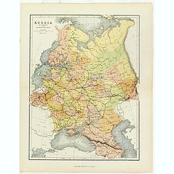
Russia in Europe with Transcaucasia.
Charming late map of Russia.
Date: London, 1880
Selling price: ????
Please login to see price!
Sold in 2018

Sketches in Russia: Popular life and manners.
Six images on one plate of Russian in typical costumes published in "The Illustrated London News" of 1880.
Date: London, 1880
Selling price: ????
Please login to see price!
Sold in 2016

Tombleson's Panoramic Map of the Thames and Medway London Published by G.W.Bacon & Co Ltd 127 Strand.
Tombleson’s Panoramic Map of the Thames and Medway London Published by G.W.Bacon & Co Ltd 127 Strand.Attractive steel engraving of the rivers Thames and Medway from...
Date: London, 1880
Selling price: ????
Please login to see price!
Sold in 2017