Subscribe to be notified if similar examples become available.
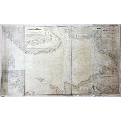
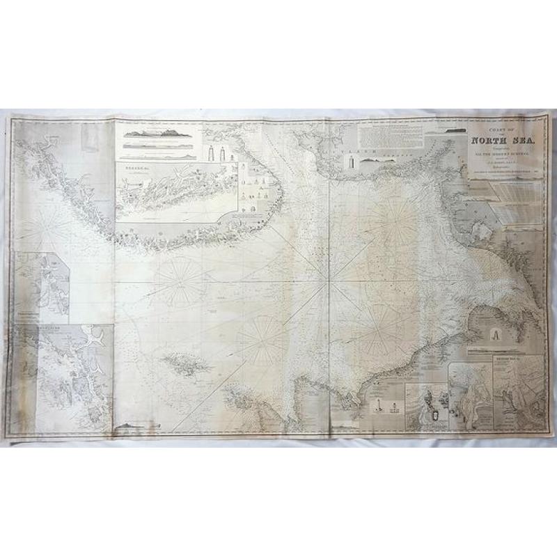
Chart of the North Sea Comprising All the Modern Surveys Drawn by J.S. Hobbs. |
||||||||||||||||||||
|
||||||||||||||||||||
|
|
||||||||||||||||||||
|
Selling price: $ Please login to see price!
Sold in 2018 Missed this item! Add your name to our mailing list and be the first to get notified about our newly added listings. . |
Collection - Save and collect this or any of your favorite items in one place.
If you want to save the items permanently, please sign in or create account first. |
|||||||||||||||||||
Description
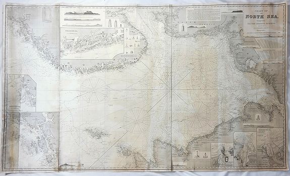
A fine antique working nautical chart of the North Sea by Norie, published in London in 1866. It was published by Charles Wilson (Late J.W. Norie and Wilson).
The seller’s original red label reads “NORTH SEA FROM LONDON TO DRONTHEIM”. The North Sea is a marginal sea of the Atlantic Ocean located between Great Britain, Scandinavia, Germany, the Netherlands, Belgium, and France.
The huge chart (3’ x 5’) features seven inserts including entrances to Aberdeen, River Tax & Dundee, Shields Bar, Drontheim, Christiansud and Bergen as well as an instruction insert “Remarks on Navigation of the North Sea”.
The chart was printed on three sheets and joined. Originally, it was backed by blue paper to provide the needed strength to withstand hard usage at sea. The backing paper was damaged from use and was removed. The seller’s red label is attached to the map and still has the blue back sample.
This was a working chart actually used on a ship. A single sheet chart was easier to use and it was possible for publishers to issue updated versions of a single chart more regularly. Thus it is that most of the charts actually used on ships over the years have been separately issued, single sheet charts. These were usually rolled with a distinctive blue paper (giving them the name “bluebacks”.)
Few of these charts survived. First, any sheet of paper being used on board a ship at sea was often subject to damage or even destruction. As well, it has always been considered important to destroy any out-of-date chart in case someone inadvertently might use it.
An out-of-date chart can be extremely dangerous for ship and crew, so most were destroyed as soon as updated charts became available. Norie's sea charts of similar large size for other locations currently sell in the $2,000 to $9,500 range.
John William Norie (1772-1843), was a mathematician, hydrographer, chart maker and publisher of nautical books most famous for his Epitome of Practical Navigation (1805) which became a standard work on navigation and went through many editions as did many of Norie's works.
This sea chart is rare. I have not found another copy featuring “The Total North Sea” on the Internet, nor can I find historical prices.
FAQ - Guarantee - Shipping
Buying in the BuyNow Gallery
This item is available for immediate purchase when a "Add to Cart" or "Inquire Now" button is shown.
Items are sold in the EU margin scheme
Payments are accepted in Euros or US Dollars.
Authenticity Guarantee
 We provide professional descriptions, condition report (based on 45 years experience in the map business)
Paulus Swaen warrants the authenticity of our items and a certificate of authenticity is provided for each acquired lot.
Condition and Coloring
We indicate the condition of each item and use our unnique HiBCoR grading system in which four key items determine a map's value: Historical Importance, Beauty, Condition/Coloring and Rarity.
Color Key
We offer many maps in their original black and white condition. We do not systematically color-up maps to make them more sellable to the general public or buyer.
Copper engraved or wood block maps are always hand colored. Maps were initially colored for aesthetic reasons and to improve readability. Nowadays, it is becoming a challenge to find maps in their original colors and are therefor more valuable.
We use the following color keys in our catalog:
Original colors; mean that the colors have been applied around the time the map was issued.
Original o/l colors; means the map has only the borders colored at the time of publication.
Colored; If the colors are applied recently or at the end of the 20th century.
Read more about coloring of maps [+]
Shipping fee
A flat shipping fee of $ 30 is added to each shipment by DHL within Europe and North America. This covers : International Priority shipping, Packing and Insurance (up to the invoice amount).
Shipments to Asia are $ 40 and rest of the world $50
We charge only one shipping fee when you have been successful on multiple items or when you want to combine gallery and auction purchases.
Read more about invoicing and shipping
FAQ
Please have a look for more information about buying in the BuyNow gallery
Many answers are likely to find in the general help section.
Collection
![]()
With Collection you can collect all your favorite items in one place. It is free, and anyone can create his or her Virtual map collection.
Unless you are logged in, the item is only saved for this session. You have to be registed and logged-in if you want to save this item permanently to your Virtual Collection.
Read More[+]
Register here, it is free and you do not need a credit card.
Add this item to
Virtual Collection
or click the following link to see my Collection.
| Digital Image Download | |
|
Paulus Swaen maintains an archive of most of our high-resolution rare maps, prints, posters and medieval manuscript scans. We make them freely available for download and study. Read more about free image download |
Click the image for a free small image download. |
In accordance with the EU Consumer Rights Directive and habitually reside in the European Union you have the right to cancel the contract for the purchase of a lot, without giving any reason.
The cancellation period will expire 14 calendar days from the day after the date on which you or a third party (other than the carrier and indicated by you) acquires, physical possession of the lot. To exercise the right to cancel you must inform Paulus Swaen Inc, of your decision to cancel this contract by a clear statement (e.g. a letter sent by post, or e-mail (amsterdam@swaen.com).
To meet the cancellation deadline, it is sufficient for you to send your communication concerning your exercise of the right to cancel before the cancellation period has expired.
