Browse Listings in Europe
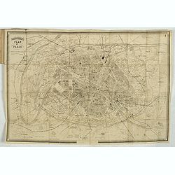
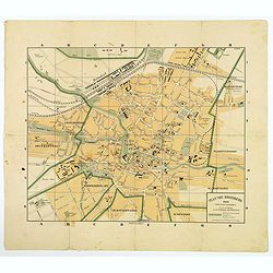
Plans of the most important cities and towns of continental Europe accompanying the special edition of Bradshw's continental railway, steam transit, &c. Guide and general handbook.
Including plans of Paris, Lyon, Marseilles, Ostend, Ghent, Brussels, Antwerp, The Hague, Cologne, Mayence, Frankfort on the Maine, Dresden, Hamburg, Munich, Berlin, Tries...
Date: Birmingham, 1880
Selling price: ????
Please login to see price!
Sold in 2020
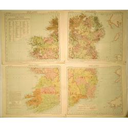
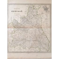
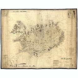
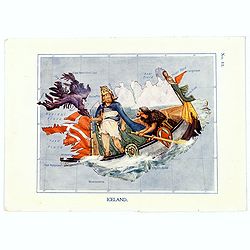
Ireland (4 Sheets).
Original map for Letts’s Popular Atlas of the World published in 1889 by Mason & Payne of London. This map is printed in color on four sheets, and has the added sta...
Date: London, c1880
Selling price: ????
Please login to see price!
Sold in 2019
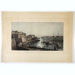
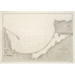
Malta, entrance to the great harbour.
Engraving of Malta harbor, drawn by A. Duncan and engraved by J. Godfrey.
Date: London, ca. 1880
Selling price: ????
Please login to see price!
Sold in 2021
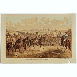
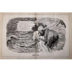
Einmarsch der russischen truppen in Romänien.
Showing the Russian arriving in Romaniia during the Russian-Turkish War (1828-1829) . Russian troops occupied Wallachia and Moldova for a few years.
Date: Dresden, 1880
Selling price: ????
Please login to see price!
Sold in 2023
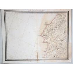
N 151. Partie de Portugal.
A lithographic atlas map, hand-colored in outline, on a conical projection. This map by Vandermaelen was published within the first atlas ever to be printed using lithogr...
Date: Brussells, 1880
Selling price: ????
Please login to see price!
Sold in 2021
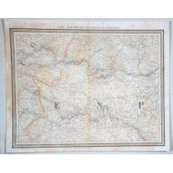
No 132 Parties de L'espagme et du Portugal.
Antique folio-sized lithographic atlas map, hand colored in outline, on a conical projection. This map by Vandermaelen was published within the first atlas ever to be pri...
Date: Brussells, 1880
Selling price: ????
Please login to see price!
Sold in 2021
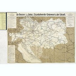
Die Österreichisch & Ungarischen Eisenbahnen der Gegewart und der Zukunst.
Rare rail-way folding map of Austria, Hungary and Galicia (centered on Lviv, or Lemberg ). Published in Vienna, by Artaria & Co. The firm was founded by the cousins C...
Date: Vienna, 1881
Selling price: ????
Please login to see price!
Sold in 2013
Carte du bassin compris entre la Sardaigne, l'Italie, et la Sicile. . . N° 021.
A detailed of the Sardinia, Italy and Sicily Basin. Corrections made in 1881.
Date: Paris, 1863-1881
Selling price: ????
Please login to see price!
Sold in 2015
Mer Baltique - Côte de Prusse - De Rixhöft A Brüsterort. . .
A well engraved and highly detailed chart focused on the Gulf of Danzig and encompassing the area between Cape Rozewie and Samland.A few places highlighted in red and yel...
Date: Paris, 1883
Selling price: ????
Please login to see price!
Sold in 2020
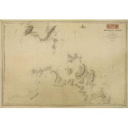
Bonifacio Strait from an Italian Government Survey, 1879. The South Coast of Corsica with the adjacent islands and rocks from a French Government Survey 1884. . .
Detailed chart of the southern Corsican coast with adjacent islands and rocks. Map is taken from an Italian Government Survey dated 1879. Lighthouses marked in yellow and...
Date: London, 1879 & updated 1883
Selling price: ????
Please login to see price!
Sold in 2010

The Imperial Coronation at Moscow.... 19 woodblock engravings
A collection of 19 woodblock engravings from "The Illustrated London News" mostly dated June 1883. The engravings display all phases of the Imperial Coronation ...
Date: London, 1883
Selling price: ????
Please login to see price!
Sold in 2016
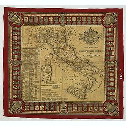
Carta dimostrativa delle Circoscrizioni Militari del Regno d'Italia 1884
Decorative military map of Italy from 1884 printed on cloth/linen. The map shows the military districts of the Kingdom of Italy in 1884 and is surrounded with coats of ar...
Date: Italy, ca.1884
Selling price: ????
Please login to see price!
Sold in 2012

A set of 16 humorous prints of Russian interest and The Russian Empire's war with the French and British Empire's.
This set of 16 are from 1853 - 1885. Mostly engraved by Joseph Swain. Joseph Swain was one of the most important woodblock engravers.Punch was responsible for the word se...
Date: London 1853 - 1885
Selling price: ????
Please login to see price!
Sold in 2016
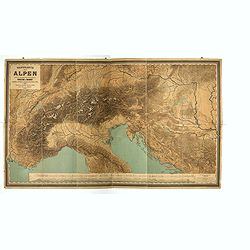
Wandkarte der Alpen nach dem Entwurfe & unter der Leitung des Vinzenz von Haardt ausgeführt in Ed. Holzel's geographischem Institut in Wien...
Large folding map of French and Swiss Alps. Hölzels' masterpiece of cartography, edited by Vincent von Haardt. Eduard Hölzel opened in 1844 a bookstore in Olomouc (now...
Date: Vienna, 1885
Selling price: ????
Please login to see price!
Sold in 2019
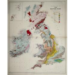
Geological map of the British Isles.
Geological map of the British Isles by Edward Best, published by Edward Stanford. Steel engraved.Shows 27 geologic units. Includes inset of the Shetland and Orkney islan...
Date: London, 1887
Selling price: ????
Please login to see price!
Sold in 2014
Mer Noire - Entrée du Liman du Dnieper et Baie de Tendra.
A fine large sea chart on the Black Sea in the Ukraine featuring the Dnieper River and the Tendra Bay. It has an insert of Liman de Berezan and shows Kinburn Spit and Ca...
Date: Paris, 1887
Selling price: ????
Please login to see price!
Sold in 2018

A set of 20 humorous prints of Russian interest and The Crimea, The Russian Empire's war with the French and British Empire's. 1849 - 1888 London 1849 - 1888
This set of 20 are from 1849 - 1888. Mostly engraved by Joseph Swain. Joseph Swain was one of the most important woodblock engravers. Punch was responsible for the word s...
Date: London, 1849 - 1888
Selling price: ????
Please login to see price!
Sold in 2016
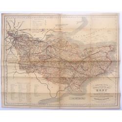
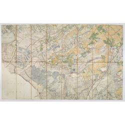
Cruchley's Road and Railway Maps of the County of Kent.
Interesting map featuring the roads and rail lines in the English county of Kent. It also shows the names of the stations, turnpike roads, villages, gentlemen's seats, im...
Date: London, 1888
Selling price: ????
Please login to see price!
Sold in 2016
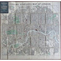
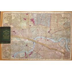
Collins Standard Map of London.
Linen backed. A famous map of London, drawn by Richard Jarman in 1858, at a scale of four inches to one statute mile, and originally published by Henry George Collins. W...
Date: London, 1888
Selling price: ????
Please login to see price!
Sold in 2018
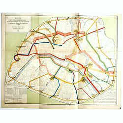
Recettes des tramways de Paris des bateaux-omnibus et du chemin de ceinture et mouvements des voyageurs dans les gares de paris en 1880.
Detailed plan of Paris showing the movements of passengers between the different stations in the year 1880. Legends in the lower right and left corners, including the num...
Date: Paris, Monrocq, 1888
Selling price: ????
Please login to see price!
Sold in 2018
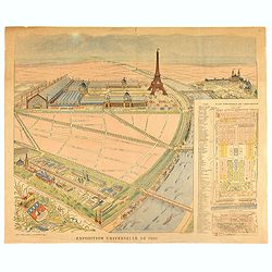
Exposition universelle de 1889.
Very rare broad sheet plan made for The Exposition Universelle of 1889, which was a world's fair held in Paris, from 6 May to 31 October 1889.A bird's eye view of the fai...
Date: Paris, Maison Quantin, 1889
Selling price: ????
Please login to see price!
Sold
![CEUX QUI BOUDENT L'EXPOSITION [THOSE WHO SHUN THE EXPOSITION].](/uploads/cache/85250-250x250.jpg)
CEUX QUI BOUDENT L'EXPOSITION [THOSE WHO SHUN THE EXPOSITION].
A chromolithograph, satirical map of Europe on the mostly negative reactions of the European nations against France ,which held the great international exposition in 1889...
Date: Paris, 1889
Selling price: ????
Please login to see price!
Sold in 2021

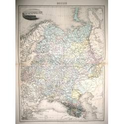
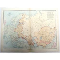
Russia & Poland.
Charming, folding map of Russia and Poland, giving a detailed overview of Europe from Baltic to Caspian Sea. Railways and rivers prominently delineated.In lower left a ke...
Date: London, ca. 1890
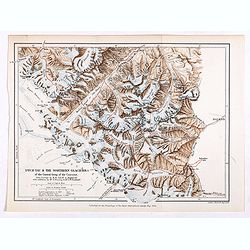
Dych-Tau & the Northern Glaciers of the Central Group of the Caucasus from surveys by M.M.Jukoff & Bogdanoff. . .
Early map of Dykh-Tau or Dykhtau, from surveys by M.M.Jukoff & Bogdanoff. Dykh-Tau is a mountain located in Kabardino-Balkaria, Russia, its peak stands about 5 km (3 ...
Date: London, Edward Stanford, 1890
Selling price: ????
Please login to see price!
Sold in 2019
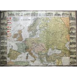
Nouvelle carte politique et commerciale de l'Europe indiquant toutes les communications maritimes, chemins de fer, et les changements des nouvelles limites des Etats d'Orient.
A large and very rare map of Europe, indicating various travelling routes. Decorated with 28 views of buildings and places in major cities such as Paris, Hamburg, Milan, ...
Date: Paris, 1890
Selling price: ????
Please login to see price!
Sold in 2019
Russie.
Full inscriptions: Russie. Grave par L. Smith. Dresse Sous La Direction De J. Migeon Par Ch. Lacoste. Migeon, editeur, imp, r. du Moulin Vert, Paris. Ecrit par A. Bizet. ...
Date: Paris, 1892
Selling price: ????
Please login to see price!
Sold in 2014
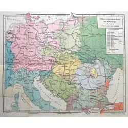
Völker-u. Sprachen-Karte von Mitteleuropa.
Interesting thematic map illustrating the nations and languages of central Europe, from Brussels to the Black Sea. Published by Artaria in Vienna.
Date: Vienna, 1893
Selling price: ????
Please login to see price!
Sold in 2016
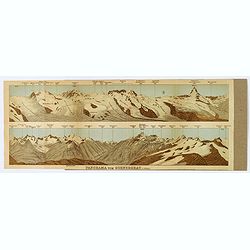
Panorama vom Gornergrat.
The Gornergrat is situated in Switzerland, between the Gornergletscher and Findelgletscher and offers views of more than 20 four-thousand metre peaks, whose highest are t...
Date: London, ca 1893
Selling price: ????
Please login to see price!
Sold in 2019
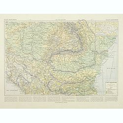
Etats Danubiens. . .
Map of east of Europe, showing Hongriae, Serbia, Bulgaria, Romania, Bosnia and part of the Black Sea up to Odessa. Text in French in lower part.This publication is in fac...
Date: Paris, E.Capiomont,1894
Selling price: ????
Please login to see price!
Sold in 2014

A set of 23 humorous Punch prints of Russian interest and The Crimea, The Russian Empire's war with the French and British Empire's. 1853 - 1894
This set of 23 prints are from 1853 - 1894. Mostly engraved by Joseph Swain. Joseph Swain was one of the most important woodblock engravers. Punch was responsible for the...
Date: London, 1853 – 1894
Selling price: ????
Please login to see price!
Sold in 2016
Tape Indicator Map of London and Visitors Guide.
A fold out linen backed hand colored plan of London by Charles Smith & Son, London, 1894. With green hardcover in good condition. Tape is present and complete.
Date: London, 1894
Selling price: ????
Please login to see price!
Sold in 2017
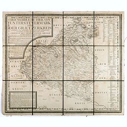
Der noerdliche Theil von Untersteyermark oder der Graetzer Kreis, Entworfen und gezeichnet von Joseph Karl Kindermann
Beautiful, rare and decorative copper engraved map of Styria, Austria. Prepared by Jos. Karl Kindermann, engraved by Christoph Junker in Vienna and published by Xavier Mi...
Date: Graetz, 1789-1894
Selling price: ????
Please login to see price!
Sold in 2018
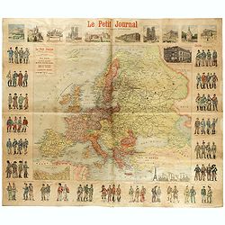
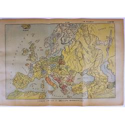
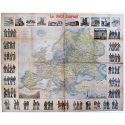
Le Petit Journal - Uniforme des armées Européennes.
French wall map sized map of Europe taken from the famous newspaper Le Petit Journal Illustré, showing the different army uniforms types in Europe, with a map of Europe....
Date: Paris, circa 1895
Selling price: ????
Please login to see price!
Sold in 2017
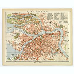
St. Petersburg.
A lovely detailed double page plan of the famous Russian city of St. Petersburg. From 'Brockhaus' Konversations-Lexikon', published by F. A. Brockhaus, in Leipzig. A num...
Date: Leipzig, 1895
Selling price: ????
Please login to see price!
Sold in 2018
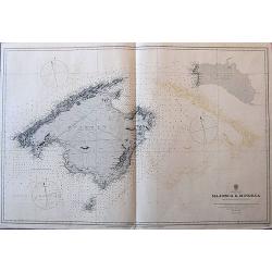
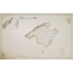
Balearic Islands Majorca & Minorca from Spanish government surveys, 1890-3.
A large sea-chart of Mallorca, Menorca, and Cabrera, published in 1897, with the magnetic variation for 1900. It gives many place names along the coasts, and some informa...
Date: London, 1897
Selling price: ????
Please login to see price!
Sold in 2017
L'Europe vue par un aeronaute impressionnable.
A rare satirical map of Europe, published in the French magazine Le Pélerin N° 1054 on March 14th, 1897. color printed, with French text on verso.More about cartographi...
Date: Paris, 1897
Selling price: ????
Please login to see price!
Sold in 2017
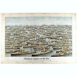
Britain's Empire on the Sea. Dedicated to Captain the Right Honourable Lord Charles Beresford...
A very decorative and large chromolithographed plate showing all the effective strength of the British navy with the name and class of each ship shown beneath, except for...
Date: Portsea, ca. 1897
Selling price: ????
Please login to see price!
Sold in 2025
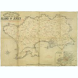
Stephens and Mackintosh Leicester. Business map of the island of Jersey.
Map of Jersey. it shows the principal roads, plus street plan St. Helier inserted in the lower right corner. Showing the distance from St. Helier in red among a key to ab...
Date: Leicester, ca. 1898
Selling price: ????
Please login to see price!
Sold in 2019
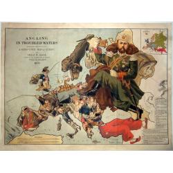
Angling in Troubled Waters A Serio-Comic Map of Europe by Fred. W. Rose Author of the 'Octopus Map of Europe' 1899.
One of the most famous serio-comic maps. A chromolithographed large caricature map of Europe with each country depicted as an angler having various levels of success in h...
Date: London, 1899
Selling price: ????
Please login to see price!
Sold in 2021
![[Italy and Spain/ Portugal].](/uploads/cache/46146-250x250.jpg)
[Italy and Spain/ Portugal].
Alexey Afinogenovich Ilyin was a lieutenant general and cartographer (1832-1889). In 1856, after graduating from the Academy of the General Staff, he was at the military ...
Date: St. Petersburg, 1899
Selling price: ????
Please login to see price!
Sold in 2023
![[Mont-Blanc].](/uploads/cache/46165-250x250.jpg)
[Mont-Blanc].
A detailed map cantered on the Mont Blanc and its vicinities published by the very successful St. Petersburg publisher "Cartographic institution A.Ilina".Alexey...
Date: St. Petersburg, 1899
Selling price: ????
Please login to see price!
Sold in 2022
![[Greece].](/uploads/cache/46170-250x250.jpg)
[Greece].
A detailed map of Greece published by the very successful St. Petersburg publisher "Cartographic institution A.Ilina".Alexey Afinogenovich Ilyin was a lieutenan...
Date: St. Petersburg, 1899
Selling price: ????
Please login to see price!
Sold in 2020
Carta de la isla de Mallorca Levantada en los anos de 1889 a 1893..
Map of the island Mallorca showing also part of Minorca and Ibiza. Inset map of the Canal entre Dragonera y Mallorca, inset profile of the coast. Lighthouses contemporary...
Date: Madrid, Deposito Hidrografico, 1900
Selling price: ????
Please login to see price!
Sold

Carta de las islas de Ibiza y Formentera Levantada en los anos 1895 a 1897..
Map showing the islands Ibiza and Formentora, engraved by L. Galvan. 5 Inset profiles of the coast. Numerous place names, soundings and sand banks are shown round the isl...
Date: Madrid, Deposito Hidrografico, 1900
Selling price: ????
Please login to see price!
Sold
![[ University building Leiden. ]](/uploads/cache/26985-250x250.jpg)
[ University building Leiden. ]
Etching by G.C.Haverkamp (1872-1926) showing the building of Leiden University on the Rapenburg, seen from beyond the canal.Signed with pencil under bottom-right by the a...
Date: Netherlands ca. 1900
Selling price: ????
Please login to see price!
Sold in 2014
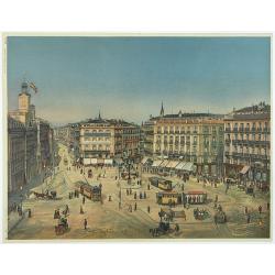
Madrid Puerta Del Sol
The Puerta del Sol (Spanish for "Gate of the Sun") is one of the most well known and busiest places in Madrid. This is the centre of the radial network of Spani...
Date: Germany, c. 1900
Selling price: ????
Please login to see price!
Sold in 2013
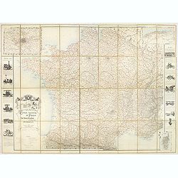
Carte routière de France de Dion Bouton spéciale pour automobiles.
Highly decorative folding wall map of France in a scale of 1 : 800 000. In the upper left hand corner an inset plan of Paris, upper right Algeria and lower right map of C...
Date: Paris, J. Barreau, no date, circa 1900
Selling price: ????
Please login to see price!
Sold in 2014
![[Two Neapolitan Gouaches.]](/uploads/cache/94508-250x250.jpg)
[Two Neapolitan Gouaches.]
2 beautifully detailed c1900 Neapolitan gouaches, showing the Bay of Naples and Mount Vesuvius.Overall size of cardboard 22 x 36,5 cm each; image size each see below. 'Go...
Date: Naples, ca. 1900
Selling price: ????
Please login to see price!
Sold in 2016
![[Hackney from Booth's Poverty Map of London]](/uploads/cache/40266-250x250.jpg)
[Hackney from Booth's Poverty Map of London]
A map of the London Borough of Hackney, one section (of twenty) of an extended version of the incredibly influential Poverty Map, originally published in Charles Booth's ...
Date: London, 1900
Selling price: ????
Please login to see price!
Sold in 2017
![[Les anciennes provinces Françaises à la ville de Saint Denis].](/uploads/cache/41682-250x250.jpg)
[Les anciennes provinces Françaises à la ville de Saint Denis].
Nine small chromolithography's trade cards for Ville de Saint Denis, each with French regions and places, with description in French on each verso.Cards of the regions : ...
Date: Paris, circa 1900
Selling price: ????
Please login to see price!
Sold in 2018
Map of Minsk gubernia.
Карта Минской губ&am...
Date: Sankt Peterburg, 1850-1900
Selling price: ????
Please login to see price!
Sold in 2018
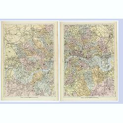
London West / East.
A detailed pair of plans of London, as it was at the turn of the last century. Different areas are multi colored. With rich detail that includes; many major roads and tho...
Date: London, ca 1900
Selling price: ????
Please login to see price!
Sold in 2019
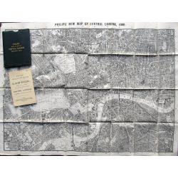
Philips New Map of Central London. 1900
Large plan of London printed on thin cloth! Shows central London in great detail, extending to Kentish Town, London Docks, South Lambeth, Notting Hill. With Philips Minia...
Date: London, 1900
Selling price: ????
Please login to see price!
Sold in 2019
Carte de l'Europe Publieépar Le Petit Journal. . .
A rare map of Europe. An interesting and very detailed map of Europe at ca.1900, designed by A. Guibal, and engraved and printed by Charaire et Cie as a separately publis...
Date: Paris, ca 1900
Selling price: ????
Please login to see price!
Sold in 2020
A Sketch of the Acquisition of Russia in Europe and Central Asia Since the Accession of Peter 1st to the Throne.
Large chromo-lithograph map of Russia with portions of surrounding countries featuring the areas of land that Russia acquired from them. Interesting historical facts are ...
Date: London, 1901
Selling price: ????
Please login to see price!
Sold in 2015

Church of Oirschot after a lightning stroke of 1904.
Fine pastel drawing by Piet Panhuizen of the church of Oirschot after it was hit by a lightning stoke in 1904. Piet Panhuizen was born in Helmond and started as designer ...
Date: Oirschot, 1904
Selling price: ????
Please login to see price!
Sold in 2009
Stafkaart Steenwijk, Kwartblad 2 Schaal 1 : 50.000.
Map of the city of Steenwijk and vicinities of Blokzijl, Wolvega, Diever, Munikeburen, etc… Scale 1 : 50,000.More about folding maps. [+]
Date: Steenwijk, 1904
Selling price: ????
Please login to see price!
Sold in 2013
![[Russia]](/uploads/cache/25601-250x250.jpg)
[Russia]
A more than 100 year old map of the world of Russia printed in lithography. Published by one of the most successful publishers of St. Petersburg A.Iljin. With a color key...
Date: St. Petersburg, c.1905
Selling price: ????
Please login to see price!
Sold in 2010
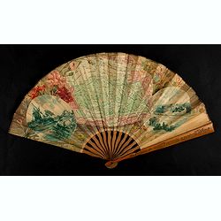
Eventail cycliste. Boulogne, Paris et ses environs.
Fan, double leaf decorated with a framed map of Bois de Boulogne and two views of Paris. The verso with two plans, one of Paris, the other from the Paris region. Wooden f...
Date: Paris, 1905
Selling price: ????
Please login to see price!
Sold in 2021
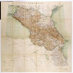
Caucasia.
Original hand-colored zincograph map of the Caucasus located at the border of Europe and Asia. The map shows part of the Black Sea and the Caspian Sea. The map is on a sc...
Date: London, 1906
Selling price: ????
Please login to see price!
Sold in 2017
A set 15 of Punch cartoons from the periods of the Russo - Japanese War of 1904 - 5 and the crisis facing the Czar.
A set 15 of Punch cartoons from the periods of the Russo – Japanese War of 1904 – 5 and the crisis facing the Czar. The titles:Melting June 15th 1904 (double Page).Ti...
Date: London, 1903-1907
Selling price: ????
Please login to see price!
Sold in 2017
Plan von Bromberg.
An interesting town plan of Bromberg (German) / Bydgoszcz (Polish) published in the town just over a century ago. The city today is in northern Poland, and is situated on...
Date: Bromberg, 1909
Selling price: ????
Please login to see price!
Sold in 2021
Iceland - Chart No. 114.
Very rare and large English nautical chart, consisting of two pages, compiled by James Imray. The bottom right the map has the title and pasted information about the 'Sou...
Date: Londen, 1910
Selling price: ????
Please login to see price!
Sold in 2023
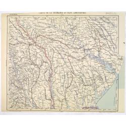
Carte de la Roumanie et Pays limitrophes. Balta. ODESSA.
Very detailed (1:750.000) map centered on Odessa and Moldova and Ukraine territory. Made after an Austrian map. The French Service géographique des armées was founded i...
Date: Paris, 1912
Selling price: ????
Please login to see price!
Sold in 2014
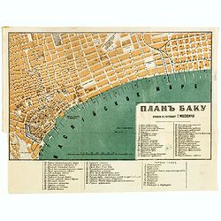
Baku (Баку, Bakı) city map, 1912
color lithographed plan of Baku (Baki) in Azerbaijan by A.Yakovenko, a publisher active in in Saint Petersburg. Scales in Russian sazhens and British inches and two numbe...
Date: Saint Petersburg, 1912
Selling price: ????
Please login to see price!
Sold in 2017
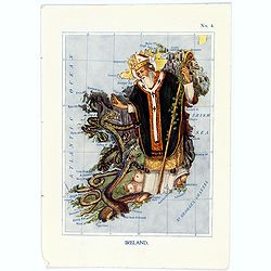
Ireland.
A fun and unusual map of Ireland, in the shape of St.Patrick banishing the serpents from the country. Map No. 4 in good printed color, shows coastal cities, towns, bays, ...
Date: London, 1912
Selling price: ????
Please login to see price!
Sold in 2017
Iceland.
A fun and unusual map of Iceland, in the shape of the Story of the Vikings. Map No. 11, in good printed color, shows fjords, and some towns. Lines of longitude and latitu...
Date: London, 1912
Selling price: ????
Please login to see price!
Sold in 2017
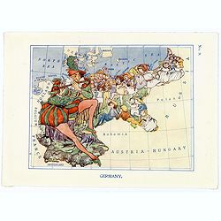
Germany.
A fun and unusual map of Germany, in the shape of the Story of the Pied Piper of Hamelin. Map No.9, in good printed color, shows some cities and towns. Lines of longitude...
Date: London, 1912
Selling price: ????
Please login to see price!
Sold in 2017
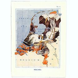
Holland.
A fun and unusual map of Holland, in the shape the Stork story of Deft. Map No.8, in good printed color, shows some cities and towns. Lines of longitude and latitude. Fro...
Date: London, 1912
Selling price: ????
Please login to see price!
Sold in 2017

(Postcard of Europe)
During the Great War, when the only means of communicating news to the masses was by newspapers and weekly illustrated magazines, the ‘war’ or 'military' picture post...
Date: Moscow, 1914
Selling price: ????
Please login to see price!
Sold in 2025

Pl. 1. - Femme en robe à la polonaise.
From Galerie des modes et costumes français dessinés d'après nature 1778-1787. Réimpression accompagnée d'une préface par M. Paul Cornu.Beautiful reissue done by th...
Date: Paris, 1912-1914
Selling price: ????
Please login to see price!
Sold in 2012

Pl. 2. - Robe à la polonaise.
From Galerie des modes et costumes français dessinés d'après nature 1778-1787. Réimpression accompagnée d'une préface par M. Paul Cornu.Beautiful reissue done by th...
Date: Paris, 1912-1914
Selling price: ????
Please login to see price!
Sold in 2012

Pl. 3. - Petite-Maitresse en robe à la polonaise.
From Galerie des modes et costumes français dessinés d'après nature 1778-1787. Réimpression accompagnée d'une préface par M. Paul Cornu.Beautiful reissue done by th...
Date: Paris, 1912-1914
Selling price: ????
Please login to see price!
Sold in 2012

Pl. 4. - Femme de qualité en déshabillé.
From Galerie des modes et costumes français dessinés d'après nature 1778-1787. Réimpression accompagnée d'une préface par M. Paul Cornu.Beautiful reissue done by th...
Date: Paris, 1912-1914
Selling price: ????
Please login to see price!
Sold in 2012

Pl. 21. - Polonaise aux manches à la circassienne.
From Galerie des modes et costumes français dessinés d'après nature 1778-1787. Réimpression accompagnée d'une préface par M. Paul Cornu.Beautiful reissue done by th...
Date: Paris, 1912-1914
Selling price: ????
Please login to see price!
Sold in 2011

Pl. 132. - Camisole à la polonaise mitigée.
From Galerie des modes et costumes français dessinés d'après nature 1778-1787. Réimpression accompagnée d'une préface par M. Paul Cornu.Beautiful reissue done by th...
Date: Paris, 1912-1914
Selling price: ????
Please login to see price!
Sold in 2012

Pl. 89. - Polonaise de toile blanche.
From Galerie des modes et costumes français dessinés d'après nature 1778-1787. Réimpression accompagnée d'une préface par M. Paul Cornu.Beautiful reissue done by th...
Date: Paris, 1912-1914
Selling price: ????
Please login to see price!
Sold in 2012

Pl. 113. - Polonaise à garniture chinée.
From Galerie des modes et costumes français dessinés d'après nature 1778-1787. Réimpression accompagnée d'une préface par M. Paul Cornu.Beautiful reissue done by th...
Date: Paris, 1912-1914
Selling price: ????
Please login to see price!
Sold in 2012

Pl. 149. - Caraco juste à la polonaise.
From Galerie des modes et costumes français dessinés d'après nature 1778-1787. Réimpression accompagnée d'une préface par M. Paul Cornu.Beautiful reissue done by th...
Date: Paris, 1912-1914
Selling price: ????
Please login to see price!
Sold in 2012

Pl. 151. - Polonaise de taffetas garnie de gaze.
From Galerie des modes et costumes français dessinés d'après nature 1778-1787. Réimpression accompagnée d'une préface par M. Paul Cornu.Beautiful reissue done by th...
Date: Paris, 1912-1914
Selling price: ????
Please login to see price!
Sold in 2012