Browse Listings in Europe
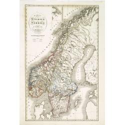
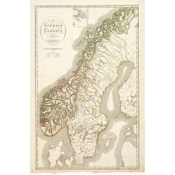
Karta öfver Sverige och Norrige.
An very rare and detailed map of Sweden and Norway with Swedish text. This is an heavenly updated version of P.B.Skölberg map of 1840 and engraved by C.Anderson in 1847....
Date: A. Wiborgs förlag, Stockholm, ca. 1848
Selling price: ????
Please login to see price!
Sold in 2019
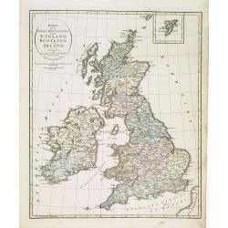
Karta öfver Stora Britannien eller England, Scotland och Irland.
An very rare map of Great Britain with Swedish text. This is an updated version of his map of 1819 and is now dated 1832.From his atlas "Geographisk Hand-Atlas"...
Date: A. Wiborgs förlag, Stockholm, ca. 1848
Selling price: ????
Please login to see price!
Sold in 2013
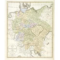
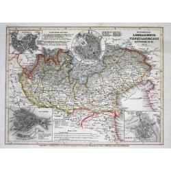
Karta öfver Tyskland.
An very rare map of Germany, Austria, and part of present-day Poland and Czech Republic with Swedish text. This is an updated version of his map of 1819 and is now dated ...
Date: A. Wiborgs förlag, Stockholm, ca. 1848
Selling price: ????
Please login to see price!
Sold in 2022
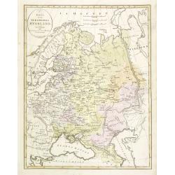
Karta öfver Ryssland.
An very rare map of European part of Russia, including Finland and Poland with Swedish text. This is an updated version of his map of 1821 and is now dated 1833.From his ...
Date: A. Wiborgs förlag, Stockholm, ca. 1848
Selling price: ????
Please login to see price!
Sold in 2013
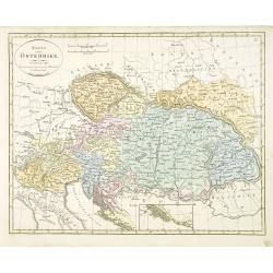
Karta öfver Österrike.
An very rare map of Austria, including present-day Hungary, Poland, Northern Italy, Trieste, the Dalmatian coast (with inset) with Swedish text. This is an updated versio...
Date: A. Wiborgs förlag, Stockholm, ca. 1848
Selling price: ????
Please login to see price!
Sold in 2016
Karta öfver Sverige och Norrige.
An very rare and detailed map of Sweden and Norway with Swedish text. This is an heavenly updated version of P.B.Skölberg map of 1840 and engraved by C.Anderson in 1847....
Date: A. Wiborgs förlag, Stockholm, ca. 1848
Selling price: ????
Please login to see price!
Sold in 2018

GEORGIEN. Costumes Persans 2.
A beautiful hand colored lithograph of a Georgian published in the French work "Galerie Royale de Costumes peints d´après nature par divers artistes et lithographi...
Date: Paris, Chez Aubert & Cie., 1842-1848
Selling price: ????
Please login to see price!
Sold in 2015

PALICAR. (Iles de l'archipel grec). Costumes Syriens 8.
A beautiful hand colored lithograph of a Palicar published in the French work "Galerie Royale de Costumes peints d´après nature par divers artistes et lithographi�...
Date: Paris, Chez Aubert & Cie., 1842-1848
Selling price: ????
Please login to see price!
Sold in 2017
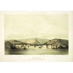
Sebastopol algemeen gezigt op de stad, de havens en de forten.
Attractive and rare lithography showing Dutch vessels off the Dutch coast, by C.C.A. Last after a painting by C.C.Kannemans. Beautiful and very rare lithography of the po...
Date: The Hague, P. Blommers, c. 1849
Selling price: ????
Please login to see price!
Sold in 2011
Österreich: Lombardisch-Venetianisches Königreich
A superbly steel-engraved map from the rare German Atlas: Meyer's Zeitungs-Atlas, considered to be the finest German Atlas of the mid 19th century!Showing the area of the...
Date: Hildburghausen, 1849
Selling price: ????
Please login to see price!
Sold
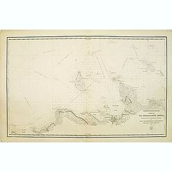
(Title in Russian : the Baltic Sea with Tallinn with the island of Naissaar.)
This rare chart of the Baltic Sea with the town of Tallinn and with the island of Naissaar.Based on the work Gavril Andreyevich Sarychev (1763-1831) which work was expend...
Date: Saint Petersburg, 1846-1849
Selling price: ????
Please login to see price!
Sold in 2013
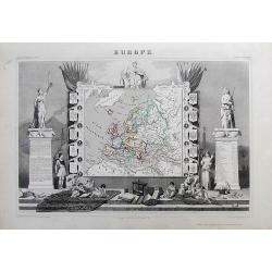
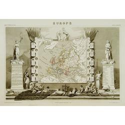
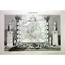
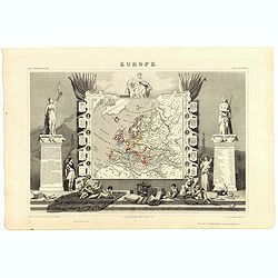
EUROPE
Charming map of the continent, surrounded by coats of arms (France, England, Spain, Italy, Switzerland, Russia, Prussia, Germany, Turkey...). Columns on the sides contain...
Date: Paris, 1849
Selling price: ????
Please login to see price!
Sold in 2012
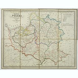
Mapa Polski za panowania Stanislawa Augusta w roku 1772.
Map of the Polish reign of Stanislaw August Poniatowski in 1772. The text is in Polish and the map is showing the cities of Cracovie, Braclaw, Minsk, etc.Published by S. ...
Date: Warsaw, 1849
Selling price: ????
Please login to see price!
Sold in 2014
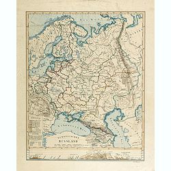
Europaïsches Russland (Manuscript map)
Map of Russia, including Finland, Poland, Sweden and Norway and the Aral Sea in the east. Signed lower right "Carl Hoeckner" and most likely drawn by Carl Hoeck...
Date: Hildburghausen, ca. 1849
Selling price: ????
Please login to see price!
Sold in 2014
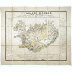
Uppdráttr Íslands / Carte d'Islande.
This rare and highly engaging map represents the first integrated (single-sheet) edition of Iceland's first accurate topographical map. Long considered among the most �...
Date: Copenhagen, 1849
Selling price: ????
Please login to see price!
Sold in 2016
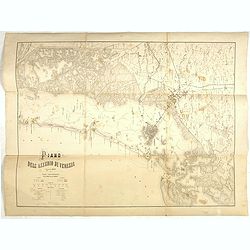
Plano dell'assedio di Venezia.
Lithographed plan of the siege of Venice (28 April – 22 August 1849). Showing in a colored key the positions of the Italian and Austrian troops. Engraved by M.Cellai.
Date: Milan, after 1849
Selling price: ????
Please login to see price!
Sold in 2022
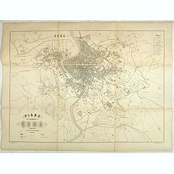
Plano dell'assedio di Roma.
Large lithographed plan of the siege of Rome in June 1849. Showing in a colored key the positions of the Roman and French troops. Engraved by M.Cellai.Siege of Rome, (30 ...
Date: Milan, after 1849
Selling price: ????
Please login to see price!
Sold in 2020
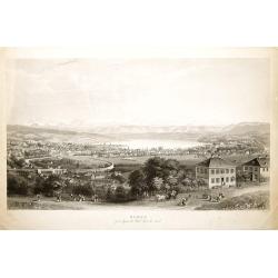
ZURICH prise depuis la Weid Coté du Nord.
Very decorative bird's-eye view of Zürich, engraved by Hurlimann and published by H.F.Leuthold. After a design by Burri.
Date: Zürich c.1850
Selling price: ????
Please login to see price!
Sold
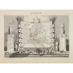
Europe.
While the map itself is quite simple without a great deal of detail, the surrounding engravings make this one of the most decorative 19th century maps. The map is framed ...
Date: Paris 1850
Selling price: ????
Please login to see price!
Sold
Manuscript map of the Southern Provinces of France.
Very detailed manuscript folding-map of the southern part of France. Including Lyon, Nice, Marseilles, Toulouse.Including the Balearic Islands of Majorca, Minorca, Ibiza....
Date: France ca. 1850
Selling price: ????
Please login to see price!
Sold in 2020
![[Untitled map of the Mediterranean countries in a playing grid].](/uploads/cache/23365-250x250.jpg)
[Untitled map of the Mediterranean countries in a playing grid].
Small, accurate map centered on the Mediterranean Basin with the adjacent countries, embedded in a square playing grid formed by 100 cells.The map presumably represents t...
Date: France, ca. 1850
Selling price: ????
Please login to see price!
Sold in 2009
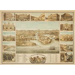
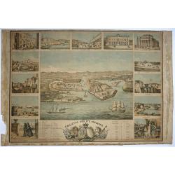
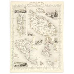
Valletta and its environs.
In center a bird's-eye view of Valletta. Surrounded by 1 views of important places in town, and 2 costume plates.RARE.
Date: England, ca 1850
Selling price: ????
Please login to see price!
Sold
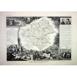
Lot of 4 French Departements
Four very decorative engraved maps of the French Departements: Haut Rhin, Loire, Lozère, Doubs. Ornately decorated borders, vignette scenes, portraits and views of the r...
Date: Paris, 1850
Selling price: ????
Please login to see price!
Sold
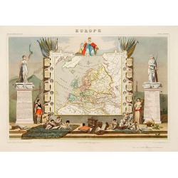
Europe
Very decorative steel-engraved map of Europe. Ornately decorated with medallion portraits of the heads of European Countries and their respective heraldic arms, Scales o...
Date: Paris, 1850
Selling price: ????
Please login to see price!
Sold
Europe.
A very decorative 19th century map showing Europe. The map is surrounded by portraits and coat of arms of European countries, cherubs, vegetation, etc.A very popular and ...
Date: Paris 1850
Selling price: ????
Please login to see price!
Sold

PARIS. Vue prise au dessus du Rond-Point des Champs-Elysées.
From Voyage aerien en France, L'Italie à vol d'oiseau. Made by Jules Arnout and printed by Lemercier. Published by A.Hauser. Bd. des Italiens.The publication is extrem...
Date: Paris, c.1850
Selling price: ????
Please login to see price!
Sold
Europe.
A very decorative 19th century map showing Europe. The map is surrounded by portraits and coat of arms of European countries, cherubs, vegetation, etc..
Date: Paris 1850
Selling price: ????
Please login to see price!
Sold
Carte militaire topographique et stratégique du Piemont.
Very detailed map of Piedmont, prepared by J.B.S. Raymond. Including the towns of Casal, Turin, Milan,
Date: Paris, Villain, 1850
Selling price: ????
Please login to see price!
Sold in 2015
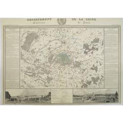
Departement de La Seine Environs de Paris.
A decorative 19th century map of the French department de La Seine with its capital Paris. The map is surrounded by two descriptive text panels to the left and right and ...
Date: Paris, ca. 1850
Selling price: ????
Please login to see price!
Sold
![[Milan and environs]](/uploads/cache/25394-250x250.jpg)
[Milan and environs]
Extremely rare large folding hand colored lithographed town-plan of Milan and its environs on 9 sheets, 11 of which each dissected into 12 sections of 14cm. sq. the centr...
Date: Milan, ca. 1850
Selling price: ????
Please login to see price!
Sold in 2016

Marchand et marchande Russes.
Lithography presenting Russian traders.
Date: Paris, c. 1850
Selling price: ????
Please login to see price!
Sold in 2019
![[Untitled map of the European countries in a playing grid].](/uploads/cache/32644-250x250.jpg)
[Untitled map of the European countries in a playing grid].
Small, accurate lithographed map of Europe, embedded in a square playing grid formed by 100 cells.The map presumably represents the extension of the territories under Rom...
Date: France, ca. 1850
Selling price: ????
Please login to see price!
Sold in 2014
![[ Montelbaanstoren in Amsterdam ]](/uploads/cache/92206-250x250.jpg)
[ Montelbaanstoren in Amsterdam ]
Interesting view of the Montelbaanstoren in Amsterdam. Highly detailed print with buildings, people, the watergate, and ships.
Date: c1850
Selling price: ????
Please login to see price!
Sold in 2012
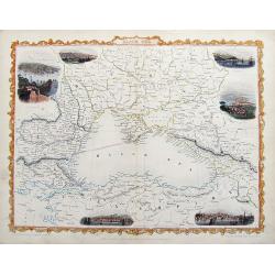
Black Sea.
A detailed and highly decorative map of the area around the Black sea. The map is enhanced by vignette illustrations of Sebastopol, Varna, Odessa, Sinope, Silistra, and ...
Date: London, 1850
Selling price: ????
Please login to see price!
Sold in 2018
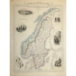
SWEDEN AND NORWAY
A highly detailed and decorative map of Norway and Sweden issued by John Tallis. Published in London, Edinburgh and Dublin circa 1850.The map has an elaborate border, and...
Date: London, 1850
Selling price: ????
Please login to see price!
Sold in 2016

Die Schlacht Von Novara.
Showing the Battle of Novara or Battle of Bicocca (Bicocca is a borough of Novara) which was one of the battles fought between the Austrian Empire and the Kingdom of Sard...
Date: Vienna, 1850
Selling price: ????
Please login to see price!
Sold in 2016
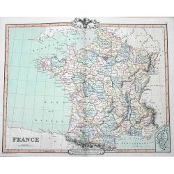
France
A fine map of France by George Frederick Cruchley. It covers all of France, seen here divided in its various departments. An inset shows the French island of Corsica. Ele...
Date: London, 1850
Selling price: ????
Please login to see price!
Sold in 2016

Kamchatka according to A.Erman . . .
FIRST EDITION Map of the Kamchatka Peninsula, Siberia, from Gazetteer of the World. Drawn by Augustus Petermann, engraved by G. H. Swanston.
Date: London / Edinburgh, 1850
Selling price: ????
Please login to see price!
Sold in 2025

Puschkin.
Steel engraved half-length portrait of Alexander Sergeyevich Pushkin, a Russian poet, playwright, and novelist of the Romantic era who is considered by many to be the gre...
Date: Germany, 1850
Selling price: ????
Please login to see price!
Sold in 2018

Plan des bords de la Berezina, de Moscou et de Smolensk.
Prepared by Thunot Duvotenay (1796-1875), a French geographer and publisher. Detailed map taken from: "Thiers, Atlas de l' Histoire du Consulat et de l' Empire"...
Date: Paris, 1850
Selling price: ????
Please login to see price!
Sold in 2016
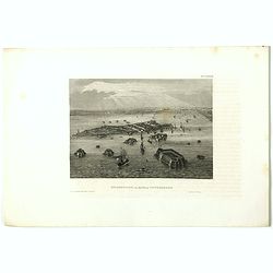
Kronstadt, in der ferne Petersburg.
View of Kiev. Original steel engraving, published by Bibliographisches Institut Hildburghausen.
Date: Hildburghausen, 1850
Selling price: ????
Please login to see price!
Sold in 2019
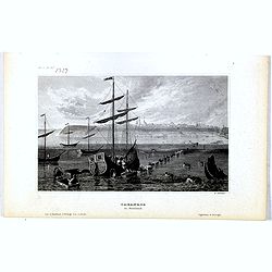
Taganrog in Russland
View of Tarangow. Original steel engraving, published by Bibliographisches Institut Hildburghausen. Engraved by E.Willmann.
Date: Hildburghausen, 1850
Selling price: ????
Please login to see price!
Sold in 2021
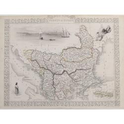
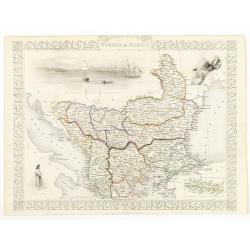
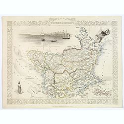
Turkey in Europe.
A very decorative steel-engraved map of South-East Europe, extending from Dalmatia until the Black Sea. Very detailed with place names, rivers, hills, bays, etc. With a s...
Date: London, ca. 1850
Selling price: ????
Please login to see price!
Sold in 2017
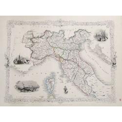
Northern Italy.
A very decorative steel-engraved map with many place names, rivers, hills, bays, islands, lakes, etc. Attractively illustrated with vignette style views of "The Gran...
Date: London, ca.1850
Selling price: ????
Please login to see price!
Sold in 2017
Europe.
While the map itself is quite simple without a great deal of detail, the surrounding engravings make this one of the most decorative 19th century maps. The map is framed ...
Date: Paris, 1850
Selling price: ????
Please login to see price!
Sold in 2023
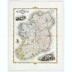
Ireland.
A delightful small map of the island of Ireland, by Alfred Adlard, published in his Vignette Modern School Atlas of the World. When looking at this map you are immediatel...
Date: London, 1850
Selling price: ????
Please login to see price!
Sold in 2018
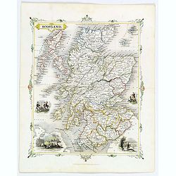
Scotland.
A delightful small map of Scotland, by Alfred Adlard, published in his Vignette Modern School Atlas of the World. When looking at this map you are immediately struck by i...
Date: London, 1850
Selling price: ????
Please login to see price!
Sold in 2018
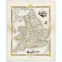
England and Wales.
A delightful small map of England and Wales, by Alfred Adlard, published in his Vignette Modern School Atlas of the World. When looking at this map you are immediately st...
Date: London, 1850
Selling price: ????
Please login to see price!
Sold in 2020
Valletta and its Environs.
A bird's-eye view of Valletta. Surrounded by views of important places in town, and two of local costume. The Brocktorffs were a family of artists who had an important li...
Date: Valetta, 1850
Selling price: ????
Please login to see price!
Sold in 2020
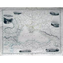
Black Sea.
A fine steel engraved map of the Black Sea and surrounding areas. With small decorative views of Sevastopol, Varna, Odessa, Sinope, Constantinople, and Silistria, all nic...
Date: London, ca 1850
Selling price: ????
Please login to see price!
Sold in 2019
![[Set of 6 tinted lithographic views of St. Petersburg.]](/uploads/cache/44570-250x250.jpg)
[Set of 6 tinted lithographic views of St. Petersburg.]
A set of 6 delightful views of St. Petersburg, with titles in both Russian and French. Published in Paris by Daziaro. Lithographed by Jacottet & Regamey. Image 1. Adm...
Date: Paris, ca 1850
Selling price: ????
Please login to see price!
Sold in 2020
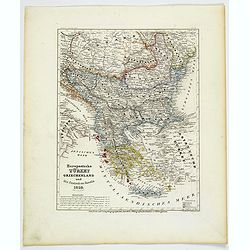
Europaeische Turkey, Griechenland und die Ionischen Inseln.
A steel-engraved outline hand color map Turkey in Europe, color-coded by region, with an explanation box lower right corner. An interesting historical map showing the reg...
Date: Hildburghausen, 1850
Selling price: ????
Please login to see price!
Sold in 2021
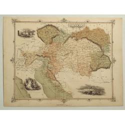
Austria.
A striking hand-colored lithographed map of Austria by Montegue. It features inserted vignettes of the city of Vienna, the Fortress of Komorn and Croatian Irregular Troop...
Date: London, ca 1850
Selling price: ????
Please login to see price!
Sold in 2019
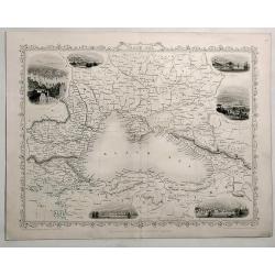
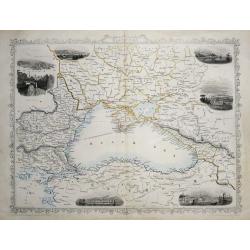
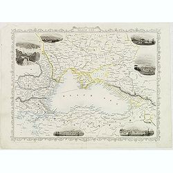
Black Sea.
Detailed and decorative map of The Black Sea with six vignettes of Sebastopol, Varna, Odessa, Sinope and Constantinople.. A John Tallis map published by The London Prin...
Date: London, 1850
Selling price: ????
Please login to see price!
Sold in 2019
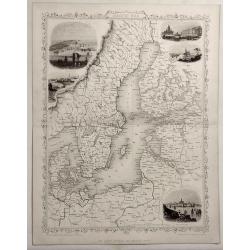
Baltic Sea.
Detailed and decorative map of The Baltic Sea with five vignettes of Kronstadt, Revel, St. Petersburg, Abo and Helsingfors. A John Tallis map published by The London P...
Date: London, 1850
Selling price: ????
Please login to see price!
Sold in 2019
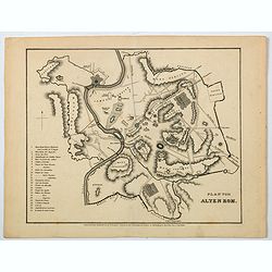
Plan vom Alten Rom.
A nice German plan of the ancient walled city of Rome, published in the mid 19th century. Down the lower left side of the plan is a numbered key (1-25) to main buildings ...
Date: Hildburghausen, ca 1850
Selling price: ????
Please login to see price!
Sold in 2021
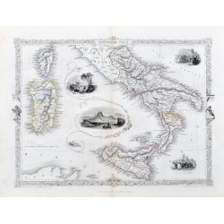
Southern Italy.
A very nice steel engraving from the atlas by R. Montgomery. The map shows southern Italy from Piombino to Sicily. Including Corsica and Sardinia. With beautiful vignette...
Date: London, Edingburgh & Dublin, ca. 1850
Selling price: ????
Please login to see price!
Sold in 2020
British possessions in the Mediterranean.
Decorative steel engraved map of the islands and possessions Gibraltar, Malta, Gozo, Corfu, Paxo, Cerigo, Zante, Cephalonia, Ithaca and Maura. Illustrations sit amongst t...
Date: London, ca. 1851
Selling price: ????
Please login to see price!
Sold
Turkey in Europe.
Decorative steel engraved map of Albania, Macedonia, Romania, Bulgaria, Moldavia and the European part of Turkey with insets of the Bosporus and Constantinople and depict...
Date: London, ca. 1851
Selling price: ????
Please login to see price!
Sold in 2011
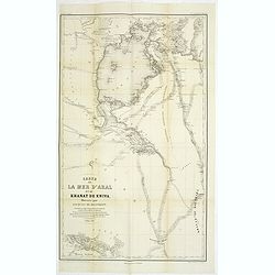
Carte de la Mer d'Aral et du Khanat de Khiva Dressée par Jacques de Khanikoff. . .
Detailed map of The Aral Sea according to Khanikoff. Khanikoff was advisor for the Russian foreign ministry of the Emperor. The map included the travel route of Mouratief...
Date: Paris, 1851
Selling price: ????
Please login to see price!
Sold in 2011
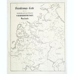
Orientirungs-Carte über die bestehenden und vorgechlagenen Canalverbindungen Russlands.
Uncommon map of the European part of Russia, showing the existing and proposed Canal system. Published in "Allgemeine Bauzeiting".The Allgemeine Bauzeitung was ...
Date: Vienna, 1851
Selling price: ????
Please login to see price!
Sold in 2011
Black Sea.
Decorative steel engraved map of the Black Sea with inset views of Sebastopol and Odessa. There are also vignettes of Constantinople, Sinope and Varna. Taken from "T...
Date: London, London Printing and publishing Company of London, ca. 1851
Selling price: ????
Please login to see price!
Sold in 2019
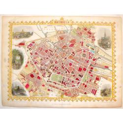
Brussels.
Striking hand-colored town plan of Tallis's "Brussels". It features vignettes of hotel de Ville, Palace royal, avenue in the Park, View from Port Anderlecht and...
Date: London, 1851
Selling price: ????
Please login to see price!
Sold in 2014
Black Sea.
Great steel engraved map of the Black Sea and surrounding areas. With small decorative views of Sevastopol, Varna, Odessa, Sinope, Constantinople, and Silistria! A decor...
Date: London, c1851
Selling price: ????
Please login to see price!
Sold in 2013
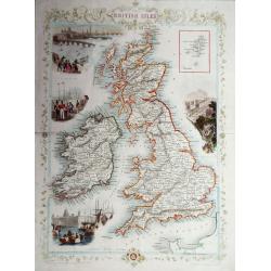
The British Isles.
A highly decorative and detailed mid-19th century map of the British Isles, which was drawn and engraved by J. Rapkin with the vignettes by John Salmon & Robert Walli...
Date: London, 1851
Selling price: ????
Please login to see price!
Sold in 2016
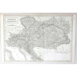
Austrian Dominions
A fine map of the Austrian empire, covering the territories claimed by the once vast Austrian empire, including in whole or part the modern day nations of Austria, Hungar...
Date: London, 1851
Selling price: ????
Please login to see price!
Sold in 2016
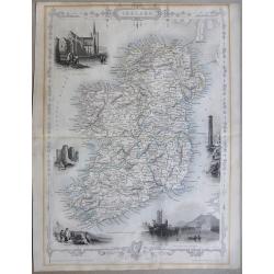
Ireland
A highly detailed and decorative map of Ireland with Illustrations of St Patricks Dublin, Limerick castle, Round Tower Wicklow, The Holy well, and Ross Castle Lake Killar...
Date: London, 1851
Selling price: ????
Please login to see price!
Sold in 2019
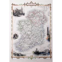
Ireland
A very decorative steel-engraved map of the island, highly detailed with place names, railroads, rivers, hills, bays, etc.Attractively illustrated with vignette style vie...
Date: London, 1851
Selling price: ????
Please login to see price!
Sold in 2016
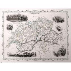
Switzerland.
A very decorative steel-engraved map of Switzerland. Very detailed with numerous place names, mountains, rivers, hills, lakes, etc. Locates the Mount Blanc, Lake Como, an...
Date: London, 1851
Selling price: ????
Please login to see price!
Sold in 2016
Turkey in Europe.
A decorative steel engraved map of Albania, Macedonia, Rumania, Bulgaria, Moldavia and the European part of Turkey with insets of the Bosporus and Constantinople and depi...
Date: London, ca. 1851
Selling price: ????
Please login to see price!
Sold in 2019
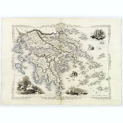
Ionian Islands and Greece.
This is John Tallis’ pretty map of the Ionian Islands and Greece. The map is surrounded by a five delicate steel engraved vignettes, and the whole is surrounded by a de...
Date: London, 1851
Selling price: ????
Please login to see price!
Sold in 2018
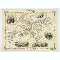
Prussia.
A nice example of this marvelous map of Prussia, surrounded by five decorative vignettes. They include the French Church in Berlin, Frederick the Great, The Royal Palace,...
Date: London, 1851
Selling price: ????
Please login to see price!
Sold in 2019
General Plan of the Antiquities of Stenness, Orkney.
General Plan of the Antiquities of Stenness and Orkney. Interesting map that covers the lochs and profiles the stones and Mees of Stenness. Drawn and engraved by James ...
Date: London, 1851
Selling price: ????
Please login to see price!
Sold in 2019
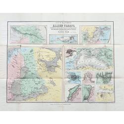
Scene of the operations of the Allied Fleets.
Scarce folding map with 11 maps showing various parts and cities. Including Caucasian Isthmus, Kronstadt, the Baltic Sea, Black Sea, St. Petersburg, the mouth of the Danu...
Date: London, ca. 1851
Selling price: ????
Please login to see price!
Sold in 2023
![Dépt. Des Bes. Du Rhône. N°12. [ Marseille, Arles, Aix ]](/uploads/cache/27091-250x250.jpg)
Dépt. Des Bes. Du Rhône. N°12. [ Marseille, Arles, Aix ]
Map of the region around Marseille, Arles, Aix in the south of France.Lovely map from one of the last decorative atlases of the nineteenth century.The rather simple map i...
Date: Paris, A. Combette, 1852
Selling price: ????
Please login to see price!
Sold in 2010
![Dépt. De La Charente. N°13. [ Cognac ]](/uploads/cache/27094-250x250.jpg)
Dépt. De La Charente. N°13. [ Cognac ]
Map of the Charente region, centered on Angouleme and Cognac. Home of the world's best-known brandy, the map shows the countryside surrounding the Charente River one hund...
Date: Paris, A. Combette, 1852
Selling price: ????
Please login to see price!
Sold in 2023
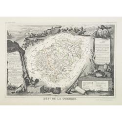
Dépt. De La Corrèze. N°18.
Map of the Corrèze region in France.Lovely map from one of the last decorative atlases of the nineteenth century.The rather simple map is framed by medallion portraits a...
Date: Paris, A. Combette, 1852
Selling price: ????
Please login to see price!
Sold in 2009
![Dépt. De La Côte D'Or. N°20. [ Lyon ]](/uploads/cache/27099-250x250.jpg)
Dépt. De La Côte D'Or. N°20. [ Lyon ]
Map of the Burgundy area, centered on Lyon.Lovely map from one of the last decorative atlases of the nineteenth century.The rather simple map is framed by medallion portr...
Date: Paris, A. Combette, 1852
Selling price: ????
Please login to see price!
Sold in 2009
![Dépt. Des Côtes Du Nord. N°21. [ St.Brieuc and St.Malo ]](/uploads/cache/27100-250x250.jpg)
Dépt. Des Côtes Du Nord. N°21. [ St.Brieuc and St.Malo ]
Map of the northern part of Brittany, including the towns of St.Brieuc and St.Malo, Dinan, etc.Lovely map from one of the last decorative atlases of the nineteenth centur...
Date: Paris, A. Combette, 1852
Selling price: ????
Please login to see price!
Sold
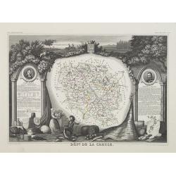
Dépt. De La Creuse. N°22.
Map of the Creuse region in France.Lovely map from one of the last decorative atlases of the nineteenth century.The rather simple map is framed by medallion portraits and...
Date: Paris, A. Combette, 1852
Selling price: ????
Please login to see price!
Sold in 2009