Browse Listings in Europe
![Dépt. Du Doubs. N°24. [ Besançon ]](/uploads/cache/27103-250x250.jpg)
Dépt. Du Doubs. N°24. [ Besançon ]
Map of the Doubs region, centered on the town Besançon in France.Lovely map from one of the last decorative atlases of the nineteenth century.The rather simple map is fr...
Date: Paris, A. Combette, 1852
Selling price: ????
Please login to see price!
Sold in 2009
![Dépt. De La Dordogne. N°25. [ Perigueux ]](/uploads/cache/27104-250x250.jpg)
Dépt. De La Dordogne. N°25. [ Perigueux ]
Map of the Dordogne region, centered on Perigueux in France.Lovely map from one of the last decorative atlases of the nineteenth century.The rather simple map is framed b...
Date: Paris, A. Combette, 1852
Selling price: ????
Please login to see price!
Sold in 2010
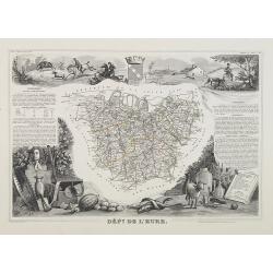
Dépt. De L'Eure. N°26.
Map of the Eure a region in France, including the area south of the River Seine from Vernon to Le Havre.Lovely map from one of the last decorative atlases of the nineteen...
Date: Paris, A. Combette, 1852
Selling price: ????
Please login to see price!
Sold in 2009
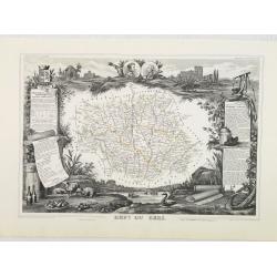
Dépt. Du Gers. N°31.
Map of the Gers region in France.Lovely map from one of the last decorative atlases of the nineteenth century.The rather simple map is framed by medallion portraits and c...
Date: Paris, A. Combette, 1852
Selling price: ????
Please login to see price!
Sold in 2010
![Dépt. De La Gironde. N°32. [ Bordeaux ]](/uploads/cache/27111-250x250.jpg)
Dépt. De La Gironde. N°32. [ Bordeaux ]
Map of the Gironde region, including Bordeaux in France.Lovely map from one of the last decorative atlases of the nineteenth century.The rather simple map is framed by me...
Date: Paris, A. Combette, 1852
Selling price: ????
Please login to see price!
Sold in 2009
![Dépt. De L'Hérault. N°33. [ Narbonne, Montpellier ]](/uploads/cache/27112-250x250.jpg)
Dépt. De L'Hérault. N°33. [ Narbonne, Montpellier ]
Map of the Hérault region, including the towns of Narbonne, Montpellier, etc in Southern France.Lovely map from one of the last decorative atlases of the nineteenth cent...
Date: Paris, A. Combette, 1852
Selling price: ????
Please login to see price!
Sold in 2009
![Dépt. Du Loiret. N°44. [ Orleans ]](/uploads/cache/27123-250x250.jpg)
Dépt. Du Loiret. N°44. [ Orleans ]
Map of the Loire region, centered on the town of Orleans and the region north of the River Loire.Lovely map from one of the last decorative atlases of the nineteenth cent...
Date: Paris, A. Combette, 1852
Selling price: ????
Please login to see price!
Sold
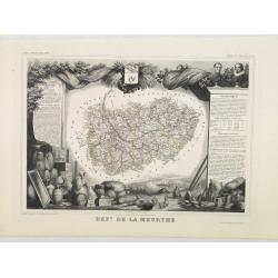
Dépt. De La Meurthe. N°53.
Map of the Meurthe region in France.Lovely map from one of the last decorative atlases of the nineteenth century.The rather simple map is framed by medallion portraits an...
Date: Paris, A. Combette, 1852
Selling price: ????
Please login to see price!
Sold in 2013
![Dépt. De La Sarthe. N°71. [ Le Mans ]](/uploads/cache/27152-250x250.jpg)
Dépt. De La Sarthe. N°71. [ Le Mans ]
Map of the Sarthe region, centered on Le Mans.Lovely map from one of the last decorative atlases of the nineteenth century.The rather simple map is framed by medallion po...
Date: Paris, A. Combette, 1852
Selling price: ????
Please login to see price!
Sold in 2010
![Dépt. De Vaucluse. N°81. [ Avignon, Carpentras, Apt ]](/uploads/cache/27161-250x250.jpg)
Dépt. De Vaucluse. N°81. [ Avignon, Carpentras, Apt ]
Map of the Vaucluse region in France, including Avignon, Carpentras, Apt, etc.Lovely map from one of the last decorative atlases of the nineteenth century.The rather simp...
Date: Paris, A. Combette, 1852
Selling price: ????
Please login to see price!
Sold in 2017
![Dépt. De La Vienne. N°83. [ Poitier ]](/uploads/cache/27164-250x250.jpg)
Dépt. De La Vienne. N°83. [ Poitier ]
Map of the Vienne region in France, centered on the town Poitier.Lovely map from one of the last decorative atlases of the nineteenth century.The rather simple map is fra...
Date: Paris, A. Combette, 1852
Selling price: ????
Please login to see price!
Sold in 2009
![Dépt. De La Hte. Vienne. N°84. [ Limoges]](/uploads/cache/27165-250x250.jpg)
Dépt. De La Hte. Vienne. N°84. [ Limoges]
Map of the Upper Vienne region, centered on the town Limoges, famous for its porcelain.Lovely map from one of the last decorative atlases of the nineteenth century.The ra...
Date: Paris, A. Combette, 1852
Selling price: ????
Please login to see price!
Sold in 2009
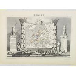
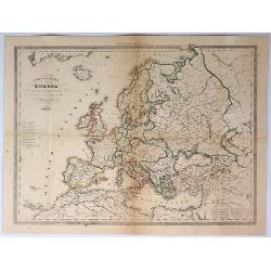
Europe.
Map of Europe, framed by medallion portraits and coats of arms down each side and is set against a background of statues and allegorical figures. A large group of adorabl...
Date: Paris, A. Combette, 1852
Selling price: ????
Please login to see price!
Sold in 2009
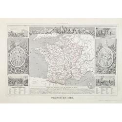
France en 1852.
A general map of France in 1852.Lovely map from one of the last decorative atlases of the nineteenth century.The rather simple map is framed by medallions showing stages ...
Date: Paris, A. Combette, 1852
Selling price: ????
Please login to see price!
Sold in 2009
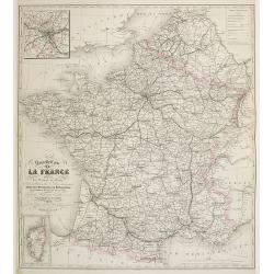
Nouvelle Carte de France indiquant les Routes de Poste . . .
post road mapsPost route map of France with two inset maps, one of Paris upper left corner, and one of Corsica lower left corner. Prepared by the geographer Charle and pu...
Date: Paris, A. Combette, 1852
Selling price: ????
Please login to see price!
Sold
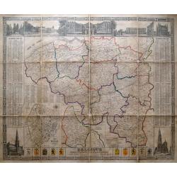
Belgique divisée en provinces et arrondissemens. . .
Scarce large size map of Belgium and Luxembourg, by D. Raes, and engraved by De Lahoese.The map is surrounded by views of important buildings, calenders of the years 1855...
Date: Bruxelles, c1852
Selling price: ????
Please login to see price!
Sold in 2014
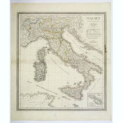
Italien.
A lovely large map of Italy, nicely colored, with a population legend and mileage scales. With plenty of good map detail and competently engraved. Inset of Malta and Gozo...
Date: Weimar, ca 1852
Selling price: ????
Please login to see price!
Sold in 2018
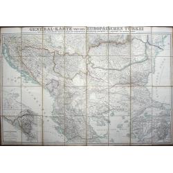
General-karte von der Europäischen Türkei nach allen vorhandenn originalkarten und itinerarischen hülfsmitteln bearbeitet und von Heinrich Kiepert
Map of present-day Greece and Turkey.
Date: Berlin, Dietrich Reimer, 1853
Selling price: ????
Please login to see price!
Sold in 2008
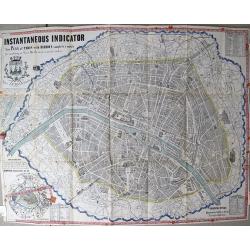
Plan Itinéraire De Paris.
Folding plan of Paris divided into numbered and lettered squares, corresponding indices of streets and public buildings to left and right edges. Original color in block a...
Date: Paris: J. Andriveau-Goujon, 1853
Selling price: ????
Please login to see price!
Sold in 2012
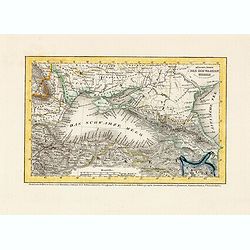
Küstenländer des Schwarzen Meeres.
Detailed steel engraved miniature map of the Black Sea region. The map was prepared and engraved by Lieutenant L. Renner., who was a military officer, recruited by Joseph...
Date: Hildburghausen / Amsterdam / Philadelphia, 1853
Selling price: ????
Please login to see price!
Sold in 2014
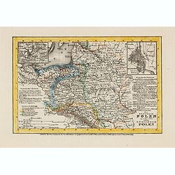
Die Republik Polen (im Jahre 1772) und das Königreich Polen.
Detailed steel engraved miniature map of South Africa, with inset maps of Vilnius and Warschau. The map was prepared and engraved by Lieutenant L. Renner., who was a mili...
Date: Hildburghausen / Amsterdam / Philadelphia, 1853
Selling price: ????
Please login to see price!
Sold in 2014
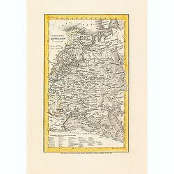
Europaeisches Russland.
Detailed steel engraved miniature map of Russia, prepared by Radefeld. The map was engraved by Lieutenant L. Renner., who was a military officer, recruited by Joseph Meye...
Date: Hildburghausen / Amsterdam / Philadelphia, 1853
Selling price: ????
Please login to see price!
Sold in 2014
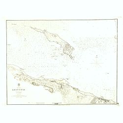
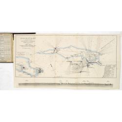
Baltic Gulf of Finland KRONSTAT from the Russian survey . . .
Large scale chart of the island of Kronstat in the Gulf of Finland. With also coast of Finland. With soundings, scale and vignette of Hydrographical office. Chart nr. 221...
Date: London, 1853
Selling price: ????
Please login to see price!
Sold in 2021
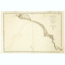
Carte particulière des cotes d'Italie (Grand Duché de Toscane). . .
Large chart showing the coast of Tuscany with the town of Cala Di Forno and Talamone. Engraved by V. Carré and J.M.Hacq.
Date: Paris, 1853
Selling price: ????
Please login to see price!
Sold in 2018
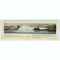
Stretto di Gibilterra.
The bottom half of a two view sheet by Corbetta. (The missing view is that of the Dardanelles in Turkey.) This colored view is that of the Strait of Gibraltar. With Itali...
Date: Milano, 1853
Selling price: ????
Please login to see price!
Sold in 2020
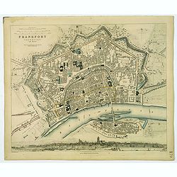
Frankfort.
A detailed plan of the German city of Frankfort, published by the Society for the Diffusion of Useful Knowledge. Streets and prominent buildings shown in great detail, to...
Date: London, 1853
Selling price: ????
Please login to see price!
Sold in 2020
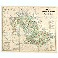
Karta öfver Färentuna härad eller det fordom så kallade Svartsjö län,
Fine and detailed map prepared by Victor Dahlgren (1815-1870).
Date: Stockholm, 1853
Selling price: ????
Please login to see price!
Sold in 2025

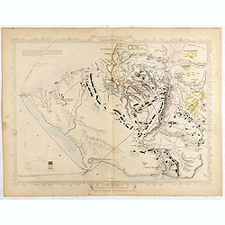
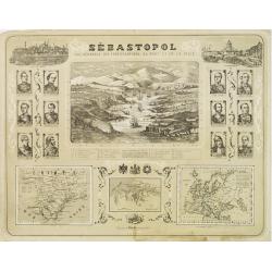
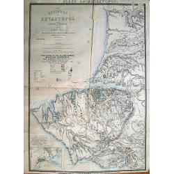
The town & harbour of Sevastopol with the batteries & approaches. . .
Rare colored linen backed map showing the harbour and town of Sevastopol, with soundings. In upper left corner a inset map (65x150mm) of the Black Sea. In bottom part a l...
Date: London, March 27th, 1854
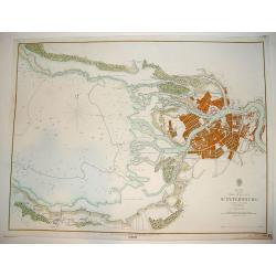
The Bay of St. Petersburg
A very rare British Admiralty nautical chart of the Bay of St. Petersburg, engraved by J & C Walker. Licensed to J. D. Potter as agent for the British Admiralty Char...
Date: Dated 1854
Selling price: ????
Please login to see price!
Sold

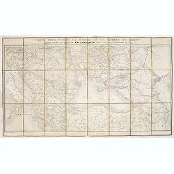
Théatre de la Guerre en Orient 1854.
Detailed map depicting the progress of the war in the Ukraine, the Crimea and the Black Sea. Including Istanbul lower left. Centered on the Black Sea area, with the north...
Date: Paris, 1854
Selling price: ????
Please login to see price!
Sold in 2009
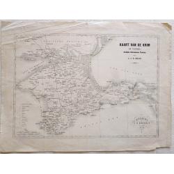
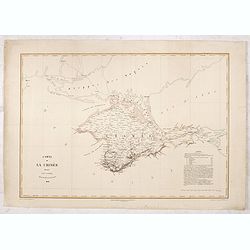
Kaart van de Krim of Taurië, (oudtijds Chersonesus Taurica).
Map of the southern part of Ukrain, between the Sea of Azov, The Black Sea, Karkinyts'ka Gulf and the Nogaic desert. After H.J.N. Huot.With the capitals, towns, villages,...
Date: Utrecht, 1854
Selling price: ????
Please login to see price!
Sold in 2013
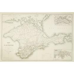
Carte de la Crimée pour suivre les opérations de la Guerre d'Orient.
Uncommon map showing the Crimea region, published to follow the Crimean war. With inset maps "Carte des pays riverains de la Mer Noire" et "Port de Sevasto...
Date: Paris, Ernest Bourdin, 1854
Selling price: ????
Please login to see price!
Sold in 2010
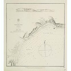
Black Sea - Baljik Bay surveyed by the officers of H.S.M.V. Spitfire 1854
of the Baljik Bay with in top a panoramic view of the town seen from the anchorage. The Baljik Bay is located in Southeastern Europe, bordering the Black Sea, between Ro...
Date: London, after 1854
Selling price: ????
Please login to see price!
Sold in 2017

A set of 10 humorous prints from the Russian Empire's war with French and British Empire's. c1854.
Ten humorous prints with the following titles: 1.The United Service 18542. The Soldiers Dream 18543. The Shooting Season 18544. God Defend The Right 18545. You Are reques...
Date: London, 1854
Selling price: ????
Please login to see price!
Sold in 2012

A set of 15 humorous prints from the Russian Empire's war with French and British Empire's. c1854.
Mostly engraved by Joseph Swain. Joseph Swain was one of the most important wood engravers of his time. Punch was responsible for the word sense "cartoon" as a ...
Date: London, 1854
Selling price: ????
Please login to see price!
Sold in 2012

A set of 10 humorous prints from the Russian Empire's war with French and British Empire's. c1854
1.Peace or War – Anyhow he Must Pay the Bill 18542.Brothers in Arms 18543.Smoke 1854 4.A Struggle Between Duty and Inclination 1854 5.The Holiday Letter 18546.Sebastopo...
Date: London, 1854
Selling price: ????
Please login to see price!
Sold in 2012
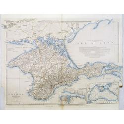
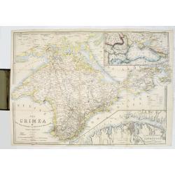
The Crimea, chiefly from surveys made by order of the Russian government. . .
Map of Crimea and the Sea of Azov. In lower right corner two inset maps showing Sebastopol inlet and harbour and a second one with the Black Sea. This second maps shows t...
Date: London, 1854
Selling price: ????
Please login to see price!
Sold in 2012
Carte des voies de cummunication de la Russie d'Erope et des etats voisins dressée par ordre se s.m. L'Empereur. . .
Detailed folding map of Northern part of Russia, prepared by L. Sagansan. The map is engraved on stone by the brothers Avril and printed by Kaeppelin in Paris.
Date: Paris, 1854
Selling price: ????
Please login to see price!
Sold in 2015
St.Petersbourg et Kronstadt.
Detailed map of the region with Kronstadt and St. Petersburg. Published by J. Correard, Directeur du journal des Sciences Militaires, R. Christine Dauphine a Paris . In l...
Date: Paris, 1854
Selling price: ????
Please login to see price!
Sold in 2013
The Crimea by James Wyld Geographer to the Queen & H.R.H. Prince Albert.
The second edition of this folding map of Crimea. In the upper right corner, an inset map of the areas around the Black Sea, "The Town & Harbor of Sevastopol wit...
Date: London, 1854
Selling price: ????
Please login to see price!
Sold in 2017
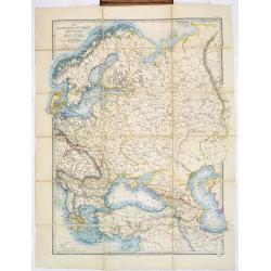
The Russian & Ottoman Empires, Sweden, Denmark, Prussia & Austria.
Detailed map of Russia, Scandinavia, Turkey, Crimea and Black Sea and Caspian Sea. Including railway from Moscow to St. Petersburg.James Wyld (the younger) was geographer...
Date: London, 1854
Selling price: ????
Please login to see price!
Sold in 2017
Cronstadt in the Baltic with the fortifications, batteries's & range of the guns &c.
A rare map showing the area around Cronstadt, which was an island defense for St Petersburg. The map includes the range of guns in addition to the position of the fortifi...
Date: London, 1854
Selling price: ????
Please login to see price!
Sold in 2015
Carte pour suivre la marche de la guerre en Orient, dressée d'après les ordres de l'empereur: par L. Sagansan.
Detailed folding map of the theatre of war in the Balkans, Ukraine and around the Black Sea, indicating the Austrian, Russian and Turkish spheres of influence, prepared b...
Date: Paris, ca. 1854
Selling price: ????
Please login to see price!
Sold in 2019
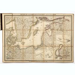
Theatre de la guerre dans la Baltique, par Mr. le Colonel LAPIE.
Excellent detailed folding map of the Baltic Sea. With inset map of Finland in lower right (195x185mm.) and inset plans of "Environs de Riga", "Plan de la ...
Date: Paris, 1854
Selling price: ????
Please login to see price!
Sold in 2014
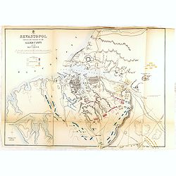
SEVASTOPOL showing the positions of the allied camps and the batteries. . . 5th edition.
Fifth edition of this fine and important single sheet lithographed plan in a scale of ca. 1:21 500 of Sevastopol. With some soundings and seabed contours. Scales in yards...
Date: London, 1854
Selling price: ????
Please login to see price!
Sold in 2014
Philips' new map of the Crimea with map of Europe and view of Sevastopol.
A well-preserved copy of this charming folding map of Russia. In lower part an inset with a panoramic view of Sevastopol. To the lower right a map of Europe.
Date: London, 1854
Selling price: ????
Please login to see price!
Sold in 2014
Philips' new map of the Crimea with map of Europe and view of Sevastopol.
A well-preserved copy of this charming folding map of Russia, Poland and the Baltic States. With charming original hardcover red wrapper richly decorated with flower desi...
Date: London, 1854
Selling price: ????
Please login to see price!
Sold in 2014
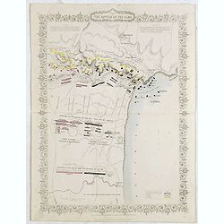
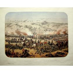
Plan of the battle of Alma.
An antique plan drawn and engraved by John Rapkin "from English and French Official Documents" Published 1858 by the London Printing and Publishing Co., London....
Date: London, 1854
Selling price: ????
Please login to see price!
Sold in 2020
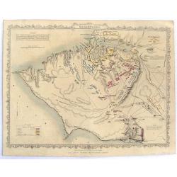
Siege of Sebastopol.
A detailed map of the Siege of Sebastopol. After the Battle of the Alma, the Allies proceeded to Sebastopol and commenced the Siege on September 26th, 1854. A steel engra...
Date: London, 1854
Selling price: ????
Please login to see price!
Sold in 2020
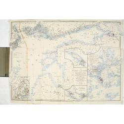
The Gulf of Finland and Baltic Sea with the fortified places from Stockholm to St.Petersburg. . . / Gulf of Bothia. / Cronstadt and St. Petersburg. . . / The harbour & entrances of Sweaborg and Helsingfors. . . Cronstadt. . .
Folding map of Gulf of Finland with several inset maps. James Wyld (the younger) was geographer to the Queen and H.R.H. Prince Albert. Joined his father's business in 183...
Date: London, 1854
Selling price: ????
Please login to see price!
Sold in 2015
Siege of Sebastopol.
Detailed steel engraving map of the Siege of Sebastopol. After the Battle of the Alma, the Allies proceeded to Sebastopol and commenced the Siege on September 26th, 1854....
Date: London, 1854
Selling price: ????
Please login to see price!
Sold in 2019
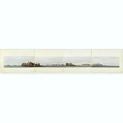
Panoramic view of the southern coast of the Crimea.
Panorama on 4 joint sheets. Impressive panorama showing the South-East coastline of Crimea from Kara-Dag and Koktebel to Feodosia, after a drawing by Captain W. H. Parker...
Date: London Dickinson, 1854
Selling price: ????
Please login to see price!
Sold in 2016
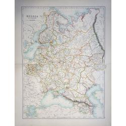
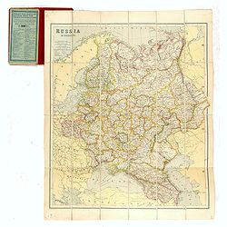
Russia in Europe
A highly detailed and attractive map of European Russia engraved by William Hughes – Sidney Hall, steel engraved.Published by Adam & Charles Black in the ‘General...
Date: Edinburgh, 1854
Selling price: ????
Please login to see price!
Sold in 2019
Carte de la Crimée dressée par D. RAMÉE, auteur du Plan de Sévastopol - 1854.
Uncommon map of Crimea, printed by Trinocq in Paris. Extensive legends in lower right corner.
Date: Paris, Garnier Frères Libraires, 1854
Selling price: ????
Please login to see price!
Sold in 2016
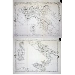
LOT OF 2: Northern Italy & Southern Italy
Lot of 2 maps of the the uncommon and slightly later edition by Rapkin based on Tallis' maps. The vignettes have been removed and the map is issued in black and white. Wi...
Date: London 1855
Selling price: ????
Please login to see price!
Sold
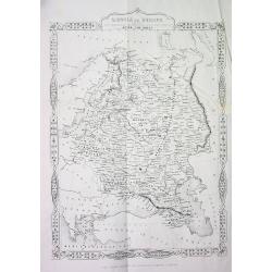
RUSSIA in EUROPE
This is the uncommon and slightly later edition by Rapkin based on Tallis' maps. The vignettes have been removed and the map is issued in black and white. A rare and desi...
Date: London, 1855
Selling price: ????
Please login to see price!
Sold in 2008
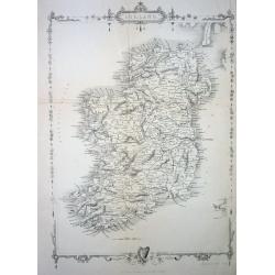
Ireland
This is the uncommon and slightly later edition by Rapkin based on Tallis' maps. The vignettes have been removed and the map is issued in black and white. With decorative...
Date: London 1855
Selling price: ????
Please login to see price!
Sold
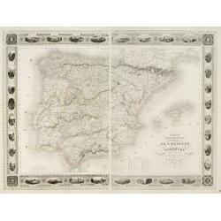
Carte Administrative, Physique et Routière De l'Espagne et du Portugal..
Steel engraving in 2 sheets representing the Iberian peninsula. Surrounded by a decorative frame composed by 32 views of Spanish towns.Title engraved by Ch. Simon.
Date: Paris, 1855
Selling price: ????
Please login to see price!
Sold
Sébastopol Vue Générale des Fortifications, du Port et de la Ville.
View of Sebastopol and its harbor, from the newspaper Le Siècle whose first issue was published in 1836. Surrounded by 2 views of Istanbul and St. Petersburg in the top ...
Date: Paris ca. 1855
Selling price: ????
Please login to see price!
Sold
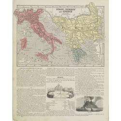
Italy, Turkey and Greece. / Holland and Belgium.
Map of Italy, Turkey and Greece. From Sidney E. Morse''s: System of Geography for the use of schools , published by Harper and brothers, 329 Pearl Street, New York.An 150...
Date: New York, 1855
Selling price: ????
Please login to see price!
Sold in 2009
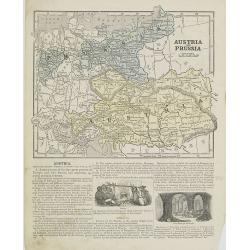
Austria and Prussia.
Map of Austria and Prussia. From Sidney E. Morse''s: System of Geography for the use of schools , published by Harper and brothers, 329 Pearl Street, New York.An 150 year...
Date: New York, 1855
Selling price: ????
Please login to see price!
Sold in 2008
Siége de Sébastopol; Siege of Sebastopol.
Panoramic lithograph view of the city and port of Sevastopol (Crimea) being attacked by British and French troops during the war of 1854/1855.A very detailed and dramatic...
Date: Paris / Lyon, c1855
Selling price: ????
Please login to see price!
Sold in 2011
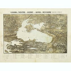
Panorama du théatre de la guerre sur les bords de la Mer Noir vu a vol d'oiseau.
Scarce plan and panoramic view of the Black Sea. With a numbered key (1-60) in lower part. Edited by Lémérey and E.Gratier. Printed with Gabiller and Molenaars.
Date: Paris, c.1855
Selling price: ????
Please login to see price!
Sold in 2011
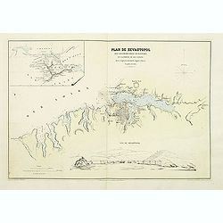
Plan de Sevastopol avec ses fortifications ses batteries et la portée de ses canons.
Map of the area around Sevastopol, engraved by Erhard and prepared by D.Ramee. Printed by Caillet. In the upper left corner is an inset plan of the Crimea. (380x555mm.). ...
Date: Paris, Caillet, 1855
Selling price: ????
Please login to see price!
Sold in 2011
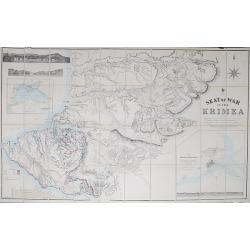
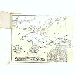
Seat of War in the Krimea.
Steel engraved folding map of the Krimea with original hand color. With panoramic views of Sevastopol, Balaklava and Eupatoria from Anchorage. Maps of the Black Sea and a...
Date: London, 1855
Selling price: ????
Please login to see price!
Sold in 2012
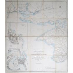
Stanford's Map of the Roads &c. Between Odessa, Nikolaief, Perekop, Simfieropol, and Sebastopol.
Folding map of south-eastern Ukraine, focusing on the region between Odessa and just east of Balaklava. Large inset maps of Odessa and Nikolayev to left edge. The whole d...
Date: London, 1855
Selling price: ????
Please login to see price!
Sold in 2012

A set of 10 humorous prints from the Russian Empire's war with French and British Empire's.
Ten humoorous prints with the following titles: - Another Russian Victory!!! July 8th 1854. - The Russian Frankenstein and His Monster July 15th 1854. - The Real ...
Date: London 1854-1855
Selling price: ????
Please login to see price!
Sold in 2012
The Environs of Sevastopol with the Batteries & Approaches.
Large lithographed plan of the Siege of Sevastopol. Shows the surroundings of the city in great topographical detail, and all the troop locations. Also indicates roads, t...
Date: London, c1855
Selling price: ????
Please login to see price!
Sold in 2012

A set of 9 humorous prints from the Russian Empire's war with French and British Empire's.
Nine humorous prints with the following titles: - The Queen visiting the Imbeciles of the Crimea,1855- Cruel Treatment of Russian Prisoners in England,1854.- Bursting of ...
Date: London, 1854-1855
Selling price: ????
Please login to see price!
Sold in 2012
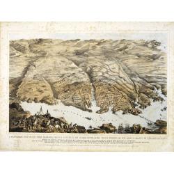
A panoramic view of the town, harbour, forts & defences of Sebastopol & the siege works of the allied armies of England & France. . .
A panoramic town-plan of the town, harbour, forts and defenses of Sevastopol in Ukraine.Chromolithographed and designed by Thomas Packer, and published by Stannard and Di...
Date: London, 1855
Selling price: ????
Please login to see price!
Sold in 2013
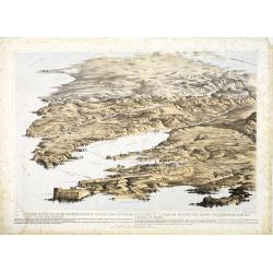
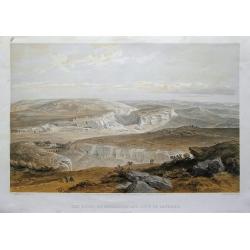
![A Panoramic View of the Position now occupied by the Allied Armies before Sebastopol [. . .] sketched by command of the Emperor Louis Napoleon by an eminent officer of the French Imperial Engineers](/uploads/cache/33753-250x250.jpg)
A Panoramic View of the Position now occupied by the Allied Armies before Sebastopol [. . .] sketched by command of the Emperor Louis Napoleon by an eminent officer of the French Imperial Engineers
A panoramic view of the position occupied by the Allied Armies before Sevastopol in Ukraine.Chromolithographed and designed by Thomas Parker, and published by Read & ...
Date: London, 1855
Selling price: ????
Please login to see price!
Sold in 2013
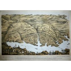
Panoramic view of the Present Extended Position of the Allied Armies of England, France, Turkey and Sardinia. - Panorama de la position presente des armées alliées, Anglaise, Française, Turque et Sarde. . .
Panoramic view of the position of the Allied Armies of England, France, Turkey and Sardinia at the south side of Sevastopol in Ukraine.Chromolithographed and designed by ...
Date: London, 1855
Selling price: ????
Please login to see price!
Sold in 2013
A Panoramic View of the Town, Harbour, Forts & Defences of Sebastopol & The Siege Works of The Allied Armies of England & France.
Printed & Published April 18th 1855 by Stannard & Dixon 7, Poland St London. A large panoramic plan of the town, harbour, forts and defenses of Sevastopol in Ukra...
Date: London, 1855
Selling price: ????
Please login to see price!
Sold in 2014
The ruins of Inkermann and city of caverns.
A spectacular view of the area of Inkerman in the Ukraine, now under Russian control (Crimean peninsula). Original colored lithograph by Day & Son. Published May 22nd...
Date: London, 1855
Selling price: ????
Please login to see price!
Sold in 2015
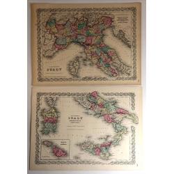
Northern Italy & Southern Italy (Two Maps)
A matched pair of maps that cover all of Italy. These beautifully engraved, hand-colored maps were published in Colton's monumental world atlas “Illustrated Atlas of th...
Date: New York, 1855
Selling price: ????
Please login to see price!
Sold in 2017
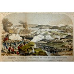
Vigorous Attack of the Allies on the Russian Ambuscades In front of the Mamelon and Malakoff Towers, May 9, 1855.
A highly detailed lithograph showing the battle to silence the Malakoff Towers. In the distance a view of Sebastopol looking towards the Dockyard Harbour... The Malakoff ...
Date: London, 1855
Selling price: ????
Please login to see price!
Sold in 2017
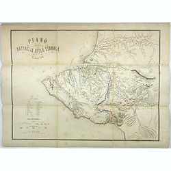
Plano della battaglia della Cernaia.
Large lithographed map showing the Battle of the Chernaya. Decorative title with numbered key (1-17) and a color key indicating the French, English, Italian, Turkish and ...
Date: Milan, 1855
Selling price: ????
Please login to see price!
Sold in 2017
Carte Generale dell Europa Divisa ne Suoi Principali Stati.
A pleasing map of Europe by Cassella, published in Turin in 1855.
Date: Turin, 1855
Selling price: ????
Please login to see price!
Sold in 2017
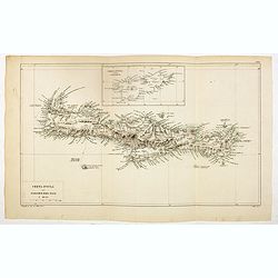
Creta Insula sec. Stadiasmum Maris Magni.
Delicate map of ancient Crete, according to the "Stadiasmus Maris Magni", prepared by Karl Wilhelm Ludwig Muller (1813-1894) and published in "Geographi Gr...
Date: Paris, Ambrosio Firmin Didot, 1855
Selling price: ????
Please login to see price!
Sold in 2017
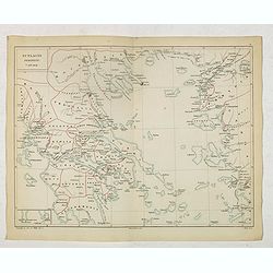
Scylacis Periplus. . .
Delicate map of ancient Greece and the West coast of Turkey according to the "Stadiasmus Maris Magni", prepared by Karl Wilhelm Ludwig Muller (1813-1894) and pu...
Date: Paris, Ambrosio Firmin Didot, 1855
Selling price: ????
Please login to see price!
Sold in 2017