Browse Listings in Europe
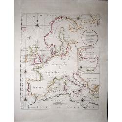
Uebersicht der Europaeischen Seeküsten verfasst von Herrn Caington Bowles. . .
A very decorative, very large map showing all European coasts: includes North sea, East sea, Atlantic ocean and the Mediterranean sea. On inset you see the eastern Medite...
Date: Vienna, 1791
Selling price: ????
Please login to see price!
Sold in 2020
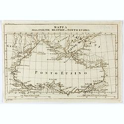
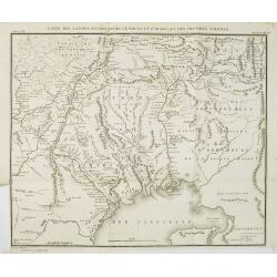
Mappa della Palude Meotide e Ponto Eusino.
An uncommon map of the Black and Azof Seas in the Crimea. Probably from Barthelemy Jean Jacques, Viaggio d'Anacarsi il giovine nella Grecia, 1791, Antonio Zatta e figli, ...
Date: Venice, 1791
Selling price: ????
Please login to see price!
Sold
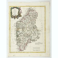
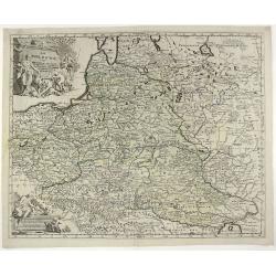
La Norvegia divisa Nelle Sue, Provincie Di nuova Projezione.
A fine large map of Norway, engraved by Zuliani after Pitteri. Few maps of Norway on its own were published during this period. Map shows the country divided into its pro...
Date: Venice, 1791
Selling price: ????
Please login to see price!
Sold in 2022
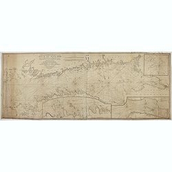
New and correct chart of the Gulf of Finland from the Russian and Swedish surveys Regulated and Ascertained by celestial observations. . .
Large scale blue-backed chart with three insets, . The Bay of Revel. The entrance of Cronstadt. The entrances to Fredrichstamn with Afpo Isles. The main chart has Saint P...
Date: London, Liverpool, 1791
Selling price: ????
Please login to see price!
Sold in 2023
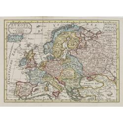
A map of Europe divided into its Empires Kingdoms &c.
Detailed map of Europe showing northern part of Africa. Prepared by L.Delarochette after Jean Pallairet (1697-1774). A geographer born in Montauban, France, who died in W...
Date: London c.1792
Selling price: ????
Please login to see price!
Sold
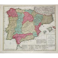
Les Royaumes d?Espagne et de Portugal.
Jan Berend Elwe. Amsterdam-based publisher. Published a pocket-atlas of the Netherlands (1786) and of Germany (1791). Published in 1792 a folio-atlas with 37 maps.A map o...
Date: Amsterdam, 1792
Selling price: ????
Please login to see price!
Sold in 2008
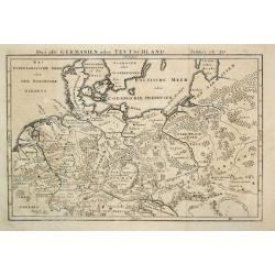
Das alte Germanien oder Teutschland.
From 'Algemeine Welthistorie (der Neuern Zeiten)', edited by S.J.Baumgarten, J.S.Semler a.o.A map of ancient Germany.
Date: Halle, 1763-1792
Selling price: ????
Please login to see price!
Sold in 2010
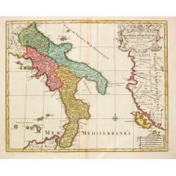
Le Royaume de Naples.
Map of the southern part of Italy, with garlands supported by cherubs.
Date: Amsterdam, 1792
Selling price: ????
Please login to see price!
Sold in 2017
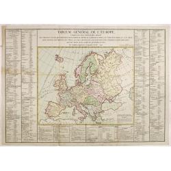
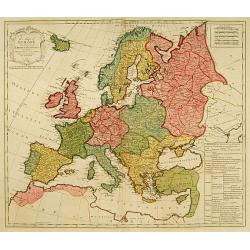
Tableau général de l'Europe,..
Uncommon map of Europe. Surrounded by geographical information for each country along with useful statistical information.Prepared by Louis Brion de la Tour and published...
Date: Paris, 1792
Selling price: ????
Please login to see price!
Sold in 2014
Les Cantons Suisses, leurs Alliés & pays sujets.
Jan Berend Elwe. Amsterdam-based publisher. Published a pocket-atlas of the Netherlands (1786) and Germany (1791). Published in 1792 as a folio-atlas with 37 maps. A re-i...
Date: Amsterdam, 1792
Selling price: ????
Please login to see price!
Sold in 2009
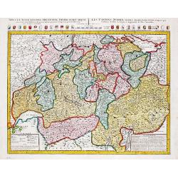
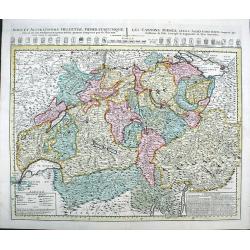
Nova et Accuratissima Helvetiae
Large map of Switzerland detailing the land from Lake Geneva to Lake Constance. The map shows the various cantons and has excellent pictorial representation of the topogr...
Date: Amsterdam, 1792
Selling price: ????
Please login to see price!
Sold in 2009
Plan de la forest de Compiègne appartenante au Roy. . .
A very decorative and rareof Forest of Compiegne, in the Picardy reggion. Including a numbered key (A-Z and 1-10) in lower part. Engraved by Pierre-Alexandre Aveline. Wit...
Date: Paris, ca.1792
Selling price: ????
Please login to see price!
Sold in 2013
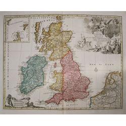
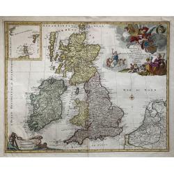
Les isles britanniques qui contiennent les royaumes d'Angleterre, Ecosse . . .
Uncommon general map of the British Isles by Jan Barendt Elwe. With decorative title cartouche and the date of publication, 1792.
Date: Amsterdam, 1792
Selling price: ????
Please login to see price!
Sold in 2010
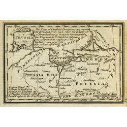
Prussia.
Uncommon miniature map from Gibson's "Atlas Minimus, or a New Set of Pocket Maps of the several Empires, Kingdoms and States of the known World".
Date: London, 1792
Selling price: ????
Please login to see price!
Sold in 2011
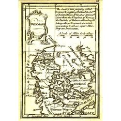
Denmark.
Uncommon miniature map from Gibson's "Atlas Minimus, or a New Set of Pocket Maps of the several Empires, Kingdoms and States of the known World".
Date: London, 1792
Selling price: ????
Please login to see price!
Sold
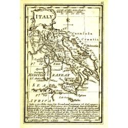
Italy.
Uncommon miniature map from Gibson's "Atlas Minimus, or a New Set of Pocket Maps of the several Empires, Kingdoms and States of the known World".
Date: London, 1792
Selling price: ????
Please login to see price!
Sold in 2011
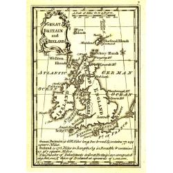
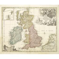
Great Britain and Ireland.
Uncommon miniature map from Gibson's "Atlas Minimus, or a New Set of Pocket Maps of the several Empires, Kingdoms and States of the known World".
Date: London, 1792
Selling price: ????
Please login to see price!
Sold in 2011
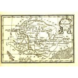
Hungary.
Uncommon miniature map from Gibson's "Atlas Minimus, or a New Set of Pocket Maps of the several Empires, Kingdoms and States of the known World".
Date: London, 1792
Selling price: ????
Please login to see price!
Sold in 2011
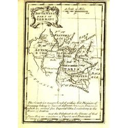
South West Part of Germany.
Uncommon miniature map from Gibson's "Atlas Minimus, or a New Set of Pocket Maps of the several Empires, Kingdoms and States of the known World".
Date: London, 1792
Selling price: ????
Please login to see price!
Sold
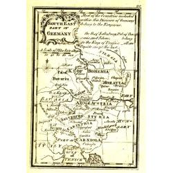
South East Part of Germany.
Uncommon miniature map from Gibson's "Atlas Minimus, or a New Set of Pocket Maps of the several Empires, Kingdoms and States of the known World".
Date: London, 1792
Selling price: ????
Please login to see price!
Sold
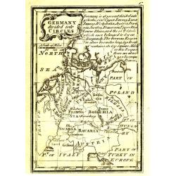
Germany divided into Circles.
Uncommon miniature map from Gibson's "Atlas Minimus, or a New Set of Pocket Maps of the several Empires, Kingdoms and States of the known World".
Date: London, 1792
Selling price: ????
Please login to see price!
Sold
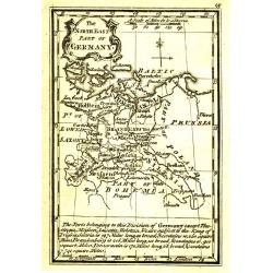
The NorthEast Part of Germany.
Uncommon miniature map from Gibson's "Atlas Minimus, or a New Set of Pocket Maps of the several Empires, Kingdoms and States of the known World".
Date: London, 1792
Selling price: ????
Please login to see price!
Sold
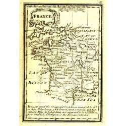
France.
Uncommon miniature map from Gibson's "Atlas Minimus, or a New Set of Pocket Maps of the several Empires, Kingdoms and States of the known World".
Date: London, 1792
Selling price: ????
Please login to see price!
Sold
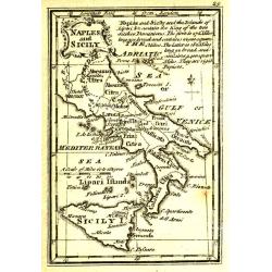
Naples and Sicily.
Uncommon miniature map from Gibson's "Atlas Minimus, or a New Set of Pocket Maps of the several Empires, Kingdoms and States of the known World".
Date: London, 1792
Selling price: ????
Please login to see price!
Sold in 2011
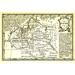
Poland.
Uncommon miniature map from Gibson's "Atlas Minimus, or a New Set of Pocket Maps of the several Empires, Kingdoms and States of the known World".
Date: London, 1792
Selling price: ????
Please login to see price!
Sold in 2011
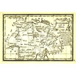
Switzerland with its Allies.
Uncommon miniature map from Gibson's "Atlas Minimus, or a New Set of Pocket Maps of the several Empires, Kingdoms and States of the known World".
Date: London, 1792
Selling price: ????
Please login to see price!
Sold
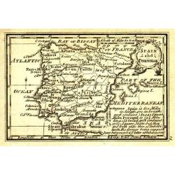
Spain and Portugal.
Uncommon miniature map from Gibson's "Atlas Minimus, or a New Set of Pocket Maps of the several Empires, Kingdoms and States of the known World".
Date: London, 1792
Selling price: ????
Please login to see price!
Sold in 2011
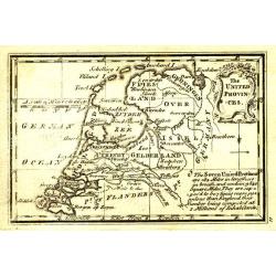
The United Provinces.
Uncommon miniature map from Gibson's "Atlas Minimus, or a New Set of Pocket Maps of the several Empires, Kingdoms and States of the known World".
Date: London, 1792
Selling price: ????
Please login to see price!
Sold
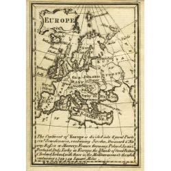
Europe.
Uncommon miniature map from Gibson's "Atlas Minimus, or a New Set of Pocket Maps of the several Empires, Kingdoms and States of the known World".
Date: London, 1792
Selling price: ????
Please login to see price!
Sold in 2011
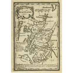
Scotland.
Uncommon miniature map from Gibson's "Atlas Minimus, or a New Set of Pocket Maps of the several Empires, Kingdoms and States of the known World".
Date: London, 1792
Selling price: ????
Please login to see price!
Sold in 2011
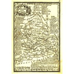
England and Wales.
Uncommon miniature map from Gibson's "Atlas Minimus, or a New Set of Pocket Maps of the several Empires, Kingdoms and States of the known World".
Date: London, 1792
Selling price: ????
Please login to see price!
Sold in 2011
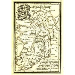
Ireland.
Uncommon miniature map from Gibson's "Atlas Minimus, or a New Set of Pocket Maps of the several Empires, Kingdoms and States of the known World".
Date: London, 1792
Selling price: ????
Please login to see price!
Sold in 2011
The Netherlands.
Uncommon miniature map from Gibson's "Atlas Minimus, or a New Set of Pocket Maps of the several Empires, Kingdoms and States of the known World".
Date: London, 1792
Selling price: ????
Please login to see price!
Sold
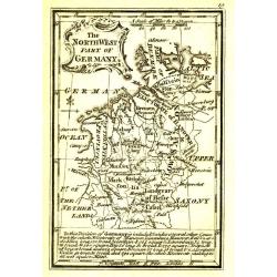
The NorthWest Part of Germany.
Uncommon miniature map from Gibson's "Atlas Minimus, or a New Set of Pocket Maps of the several Empires, Kingdoms and States of the known World".
Date: London, 1792
Selling price: ????
Please login to see price!
Sold
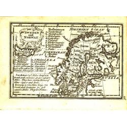
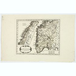
Sweden and Norway.
Uncommon miniature map from Gibson's "Atlas Minimus, or a New Set of Pocket Maps of the several Empires, Kingdoms and States of the known World".
Date: London, 1792
Selling price: ????
Please login to see price!
Sold
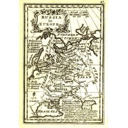
Russia in Europe.
Uncommon miniature map from Gibson's "Atlas Minimus, or a New Set of Pocket Maps of the several Empires, Kingdoms and States of the known World".
Date: London, 1792
Selling price: ????
Please login to see price!
Sold in 2011
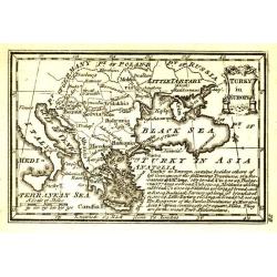
Turky in Europe.
Uncommon miniature map from Gibson's "Atlas Minimus, or a New Set of Pocket Maps of the several Empires, Kingdoms and States of the known World".
Date: London, 1792
Selling price: ????
Please login to see price!
Sold in 2011
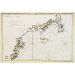
Côtes de France : Département du Var, comprenant le Golfe de la Napoule et le Gourjean. . .
Uncommon of part of the French Mediterranean seaboard centered on the Îles de Lérins and La Napoule gulf with Cannes and Nice. It covers the coast extending from the a...
Date: Paris, 1792
Selling price: ????
Please login to see price!
Sold in 2011
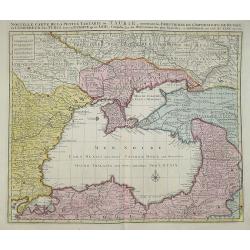
Nouvelle carte de la petite Tartarie ou Taurie, montrant les frontiers de l\'imperatrice de Russie et l\'empereur des Turcs, tant en Europe qu\'en Asie. by J B Elwe....
J B Elwe This map shows the region of the Black Sea surrounded by Russia, Bulgaria, Poland, and Turkey.
Date: Amsterdam, 1792
Selling price: ????
Please login to see price!
Sold in 2011
![Cartes Des Courones Du Nord Jan.B.Elwe MDCCXCII [2 sheets]](/uploads/cache/91753-250x250.jpg)
Cartes Des Courones Du Nord Jan.B.Elwe MDCCXCII [2 sheets]
Norway Sweden & Denmark on 2 sheets each 450 x 610mm Initially derived from a De L'Isle map these 2 sheets are printed from plates engraved by R 7 J Ottens in c1725. ...
Date: Amsterdam, 1792
Selling price: ????
Please login to see price!
Sold in 2011
Les Isles Britanniques qui contiennent les Royaumes d' Angleterre, Escosse, et Irlande distingues en leurs principales Provinces...
Jan Elwe's edition of Alexis Hubert Jaillot's fine map of the British Isles was issued nearly 100 years after it first appeared. The title cartouche is embellished with p...
Date: Amsterdam, 1792
Selling price: ????
Please login to see price!
Sold in 2013
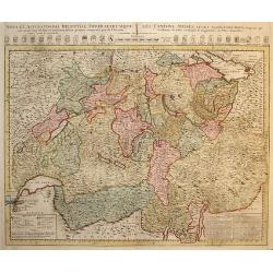
Nova et Accuratissima Helvetiae Foederatarumque... per de l'Isle
Large map of Switzerland detailing the land from Lake Geneva to Lake Constance. At the top of the map is a row of armorial shields for the cantons noting whether they wer...
Date: Amsterdam, 1792
Selling price: ????
Please login to see price!
Sold in 2011
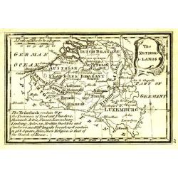
CARTE NOUVEUE DE PAIS BAS CATHOLIQUES
A detailed map showing Belgium and Luxembourg besides part of France. Probably printed from an old plate by De l'Isle with the imprint altered by Elwe.
Date: Amsterdam, 1792
Selling price: ????
Please login to see price!
Sold in 2015

North-East View of Tamworth Church.
Fine hand-colored engraving of the Tamworth Church engraved by Francis Jukes after Stebbing Shaw. It was dedicated to Edward Repington. The church of St. Editha, in Tamw...
Date: London, 1792
Selling price: ????
Please login to see price!
Sold in 2013
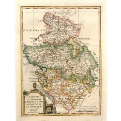
L'Anjou il Saumurois Il Poitou L'Aunis La Saintonge e L'Angoumois.
Copper engraving from the rare Geographical Atlas published in Siena by Pazzini Carli between 1798 and 1800, which can be considered a sort of dress rehearsal for the mos...
Date: Florence, 1792
Selling price: ????
Please login to see price!
Sold in 2017
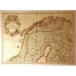
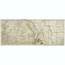
Carte des Courones du Nord.
A decorative map of Northern Scandinavia. The map shows part of the Kingdom of Norway, Swedish Lapland, Oulu, and Vasaa. Until 1775, the latter was known under Ostrobothn...
Date: Amsterdam, 1792
Selling price: ????
Please login to see price!
Sold in 2019
Carte des Courones du Nord.
A decorative map of Northern Scandinavia. The map shows part of the Kingdom of Norway, Swedish Lapland, Finland, Oulu and Vasaa, until 1775. The map was dedicated to Prin...
Date: Amsterdam, 1792
Selling price: ????
Please login to see price!
Sold in 2016
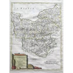
Normandia col Maine e Perche.
Unusual Italian map of Normandy - from Cherbourg to Le Tréport in the north and extending until Chartres, Laval, and Le Mans. With a large decorative title cartouche and...
Date: Siena, 1792
Selling price: ????
Please login to see price!
Sold in 2016
La Pologne Divisee en Royaume de Pologne et les etats y partenans La Pologne Prussienne Autrichienne & Russienne.
A rare map of Poland, Lithuania, Latvia, Belarus and Ukraine, with large portions now controlled by Russia, Prussia and Austria, published by Jan Elwe in Amsterdam. The m...
Date: Amsterdam, 1792
Selling price: ????
Please login to see price!
Sold in 2018
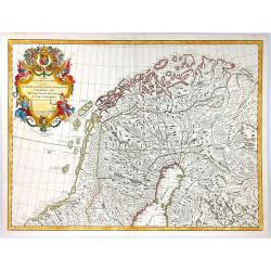
Das Konigreich Norwegen.
Von Reilly's map of Norway, published in the ‘Schauplatz der fünf Theile der Welt, Vienna, 1792. It shows central and southern Norway, with the northern half as an ins...
Date: Vienna, 1792
Selling price: ????
Please login to see price!
Sold in 2021
Les Isles Britannique qui contiennent les Royaumes d'Angleterre, Ecosse et Irlande.
A large folio format hand colored copper engraving of Great Britain, with The Netherlands and Belgium also depicted, published in Amsterdam in 1792 by Jan Barent Elwe. Sc...
Date: Amsterdam, 1792
Selling price: ????
Please login to see price!
Sold in 2019
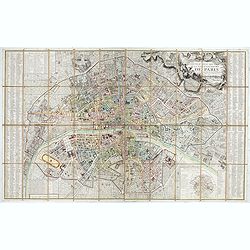
Nouveau plan routier de la ville et faubourgs de Paris Divisé en 48 sections d'après le Décret de l'Assemblée.
Beautiful plan of Paris in original colors. Second edition dated 1792 of five issues published between 1790 and 1797.Title cartouche decorated with a view of the Seine, a...
Date: Paris, 1792
Selling price: ????
Please login to see price!
Sold in 2020
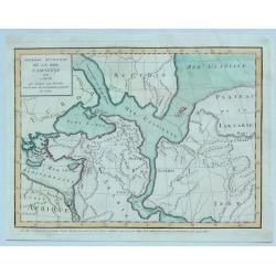
Premiere Revolution de la Mer Caspiernne. . .
One of four maps of the Caspian Sea by Delisle in 1792. This map represents an early period in which the Caspian sea was connected to other known Asiatic waters including...
Date: Paris, 1792
Selling price: ????
Please login to see price!
Sold in 2023
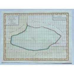
Seconde Revolution de la Mer Caspienne. . .
This map depicts the Caspian Sea according to 2nd century BC Alexandrian geographer Claudius Ptolemy. This map depicts the Caspian Sea surrounded by the coasts of Persia,...
Date: Paris, 1792
Selling price: ????
Please login to see price!
Sold in 2023
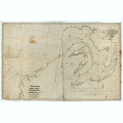
To Her Serene Highness the Empress of all the Russias, This Chart of the White Sea from the North Cape to Archangel and Onega ..
Rare chart dedicated to Catherine II (1729-1796). The chart consists of several inset charts: 1. "A Chart of the River Dwina to Archangel. The Depth of Water in Fe...
Date: London, 1792
Selling price: ????
Please login to see price!
Sold in 2023
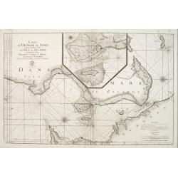
Carte du detroit du Sond contenant les costes de L'Isle de Zélande comprises entre Nicopen et l'Isle de Meun, et celles du Schonen ..
This large scale coastal chart which is oriented so that the west is at the top of the page, shows the north-eastern island of Denmark, Sjaelland on which is located Cope...
Date: Versailles c.1793
Selling price: ????
Please login to see price!
Sold
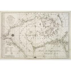
Carte de la Mer de Dannemark et des entrées dans la Mer Baltique contenant les bancs, passes, isles et costes comprises depuis Norden et le Cap Der-Neus ..
A large and detailed nautical chart in Mercator projection, showing the seas surrounding Denmark and between Denmark, Norway and Sweden, from Jacques Nicolas Bellin?s ca....
Date: Versailles c.1793
Selling price: ????
Please login to see price!
Sold
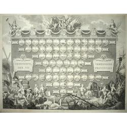
Gedenkzuyl Der VII Vereenigde Provincien.
Large engraving of a "statue" of the 7 provinces of The Netherlands with all the 57 cities sorted per province, below the name of the city in a number the walki...
Date: Amsterdam, 1793
Selling price: ????
Please login to see price!
Sold in 2012
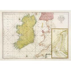
Carte Generale des Costes D\' Irlande, et des Costes Occidentales D\' Angleterre avec une Partie de celles D\' Ecosse.
Large-scale sea chart covering all of Ireland and the western coasts of England, Wales and Scotland. With inset Carte de la Riviere de Dee, ou de Chester depuis son Entr�...
Date: Paris c.1793
Selling price: ????
Please login to see price!
Sold in 2009
Les environs de Louvain, Tirlemont, . . . Les environs de Limbourg, Bolduc, . . .
Detailed map of Belgium. Showing the cities of Louvain, Liege, Diest, Maastricht and Aix la Chapelle, Cologne, etc. The map was prepared by Jean Baptiste de Bouge (1757-1...
Date: Bruxelles, 1793
Selling price: ????
Please login to see price!
Sold in 2011
Les environs de Namur, Dinant,. . .Les environs de SPA, Stavelot, . . .
Detailed map of Belgium, showing the cities of Namur, Dinant, Spa, Stavelot. The map was prepared by Jean Baptiste de Bouge (1757-1833), who prepared one of the first ver...
Date: Bruxelles, 1793
Selling price: ????
Please login to see price!
Sold in 2011
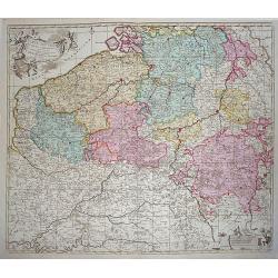
Nouvelle carte chorographique des Pays Bas Autrichiens dédiée aux amateurs des arts. . .
Map of Belgium and Zeeland in the Netherlands. On the left a beautiful title cartouche with putti.The map was prepared by Jean Baptiste de Bouge (1757-1833), who prepared...
Date: Bruxelles, 1793
Selling price: ????
Please login to see price!
Sold in 2011
Les environs de Bois-le-duc, Breda, Eyndhoven. . .Les environs de Ruremonde, Venlo. . .
Map of Brabant including the cities of Breda, s-Hertogenbosch and Northern Limburg with Venlo and Roermond.The map was prepared by Jean Baptiste de Bouge (1757-1833), who...
Date: Bruxelles, 1793
Selling price: ????
Please login to see price!
Sold in 2011
Dei Markfraftschaft Maehren, Nro. 114.
Hand-colored copper engraved map of Moravia. Interesting cartouche with three hunting dogs and a rifle. Joseph von Reilly (1766 – 1820) was a Viennese art dealer who t...
Date: Vienna, 1793
Selling price: ????
Please login to see price!
Sold in 2016
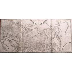
Carte générale de l\'empire de Russie 1787.
Monumental map of Russia. One of the largest maps of the 18th century! Extends from Moscow until Kamtschatka and the border to China. Includes a small part of Alaska. Pub...
Date: Paris, 1793
Selling price: ????
Please login to see price!
Sold in 2014
Il Circulo di Svevia.
"The Circle of Swabia" and below "1793 at Siena Pazzini Carli". The map comes from "Atlante Geografico...", the rare geographical atlas that...
Date: Siena, 1793
Selling price: ????
Please login to see price!
Sold in 2018
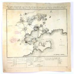
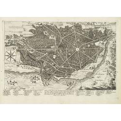
Pianta di Forti, e Trincieramenti Della Vitta di Tolone
A bird’s-eye view of the fort Toulon, France with the surrounding area. The map features the siege of Toulon which took place in 1793. After loyalist royalists had take...
Date: Paris, 1793
Selling price: ????
Please login to see price!
Sold in 2016
Les environs de Bois le Duc, Breda. . .Les environs de Ruremonde. . .
Detailed map of Brabant. Showing the cities of Breda, s-Hertogenboch, Eindhoven, Roemond, Venlo, Gueldre etc. The map was prepared by Jean Baptiste de Bouge (1757-1833).
Date: Bruxelles, 1793
Selling price: ????
Please login to see price!
Sold in 2017
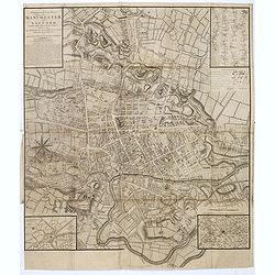
A Topographical plan of Manchester and Salford with the adjacent parts, shewing also the different allotments of land proposed to be built on as communicated to the Surveyor by the respective proprietors. . .
A Topographical plan of Manchester and Salford with the adjacent parts, with inset of a plan of Manchester and Salford and it environs, taken about 1650. The plan shows p...
Date: John Stockdale, London, 1793
Selling price: ????
Please login to see price!
Sold in 2020
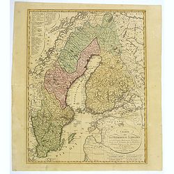
Charte uber das Konigreich Schweden. . .
A detailed map of the Kingdom of Sweden, which until 1809 included Finland, which was then lost to Russia. The original tri-colors of the map are typical of the period. S...
Date: Nuremberg, 1793
Selling price: ????
Please login to see price!
Sold in 2018

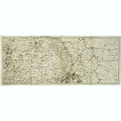
Imperium Russicum, cum regionibus adiacentibus duabus Tabulis ex optima quae A. 1784 tribus foliis comparavit Mappa geographica, aliisque subsidiis delineatum a C. Mannert, Tabula Ima. . .
A detailed map of the European part of the Russian Empire. Scarce map. Copper etching by C. Mannert and edited by Adam Gottlieb Schneider and Johann Christoph Weigel. Man...
Date: Nuremberg, 1794
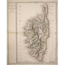
Département de l'Isle de Corse..
Detailed map of Corsica prepared and published by Doudan Dumez in his Atlas de la France.. par une société d'ingénieurs François..
Date: Paris 1794
Selling price: ????
Please login to see price!
Sold
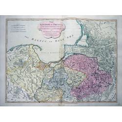
The Kingdom of Prussia...
Large and very detailed map showing parts of today Poland, Kaliningrad Oblast, and Lithuania. Detailed map, includes the cities of Gdansk, Konigsberg (Kaliningrad), Memel...
Date: London, 1794
Selling price: ????
Please login to see price!
Sold in 2012
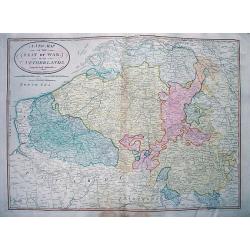
A New Map of the Seat of War in the Netherlands.
Large detailed map of Belgium, including parts of France, Luxembourg, Germany, and the Netherlands. Shows the status of the French Revolutionary Wars in 1794. Important m...
Date: London, 1794
Selling price: ????
Please login to see price!
Sold in 2012
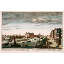
A view of the Admiralty at Amsterdam of the store houses, wharfes.. To the East India Company of Holland. . .
Decorative view of the headquarters of the V.O.C. (present-day Maritieme Museum) and their wharfes and docks, with extensive shipping. After a design by Peter van Rijne.
Date: London, 1794
Selling price: ????
Please login to see price!
Sold in 2022
Europa volgens de nieuwste verdeeling.
Uncommon map of Europe with Dutch title and text.Published in "Boertige reis door Europa", by A.Fokke.Printed by Francois Bohn in Haarlem, who was active from 1...
Date: Haarlem, 1794
Selling price: ????
Please login to see price!
Sold in 2009
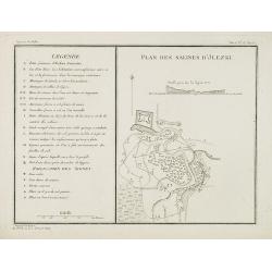
Plan des salines d'Jlezki.
Map from a second French edition of Peter Simon Pallas' Voyages du Professeur Pallas, dans Plusieurs Provinces de l'Empire de Russie et dans l'Asie Septentrionale, engrav...
Date: Paris, Maradan, 1794
Selling price: ????
Please login to see price!
Sold in 2010
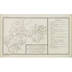
Carte de la contrée qui s'étend le long de la Soka. . .rivieres de Sourgout et de Schoumbout.
Map from a second French edition of Peter Simon Pallas' Voyages du Professeur Pallas, dans Plusieurs Provinces de l'Empire de Russie et dans l'Asie Septentrionale, engrav...
Date: Paris, Maradan, 1794
Selling price: ????
Please login to see price!
Sold in 2010
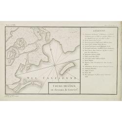
Cours de l'Iaik au dessous de Gourief.
Engraved map of the estuary of the river Ural south of Gurjev. Map from a second French edition of Peter Simon Pallas' Voyages du Professeur Pallas, dans Plusieurs Provin...
Date: Paris, Maradan, 1794
Selling price: ????
Please login to see price!
Sold in 2010
Carte des Landes situées entre le Volga et l'Oural, et des contrées voisines.
Map of the north of the Caspian sea, including Astrakhan, Orenburg, etc. Map from a second French edition of Peter Simon Pallas' Voyages du Professeur Pallas, dans Plusie...
Date: Paris, Maradan, 1794
Selling price: ????
Please login to see price!
Sold in 2010