Browse Listings in Europe
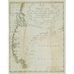
Kort over Gronland ..
Uncommon map of Greenland from: Efterretninger om Grønland, uddragne af en Journal holden fra 1721 til 1788.Prepared by Paul Egede, who was the son of the Lutheran missi...
Date: Copenhagen 1788
Selling price: ????
Please login to see price!
Sold
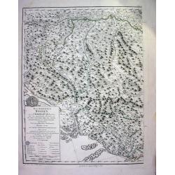
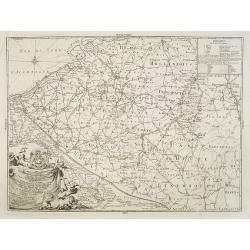
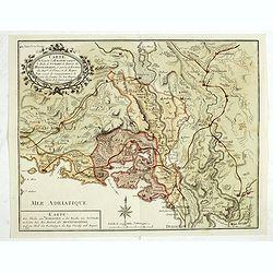
Das Koenigreich Bosnien, und die Herzegovina (Rama)
Large copper-engraved wallmap showing Bosnia and Herzegovina, large parts of Dalmatia, the Republic of Dubrovnik, parts of Croatia, Slavonia, Serbia, Albania and Macedoni...
Date: Vienna, 1788
Selling price: ????
Please login to see price!
Sold
![Karte von Italien Verfasst von Herrn D' Anville.. [2 sheets]](/uploads/cache/22196-250x250.jpg)
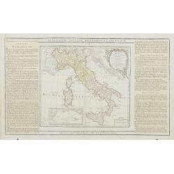
Karte von Italien Verfasst von Herrn D' Anville.. [2 sheets]
Large two-sheet map of Italy, covering the entire peninsula, from the Alps as far as Apulia. It shows also Sicily, Sardinia, Corsica, Malta, Part of the Tunisian coast, I...
Date: Vienna 1788
Selling price: ????
Please login to see price!
Sold
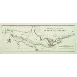
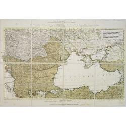
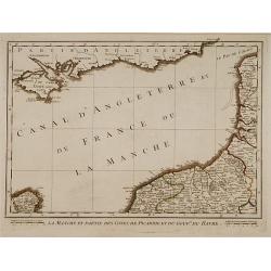
Confluent et Embouchure du Bog et du Dniéper..
Showing the mouth of the river Dnieper and the Black Sea, with border lines for the year 1787 and 1788 during the Russian, Turkish War.
Date: Vienna, c.1788
Selling price: ????
Please login to see price!
Sold
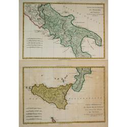
Partie Septentrionale du Royaume de Naples / Partie Méridionale du Royaume de Naples et celui de 'l' Isle de Sicile.
Rigobert Bonne (1727-1795), French cartographer. His maps are found in a.o. Atlas Moderne (1762), Raynal's Histoire Philos. du Commerce des Indes (1774) and Atlas Encyclo...
Date: Paris, 1787-1788
Selling price: ????
Please login to see price!
Sold in 2019
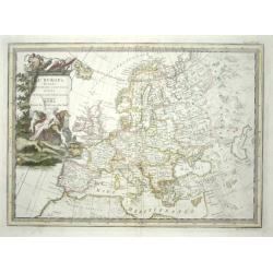
L' Europa Secondo Le ultime osservazioni divisa ne' suoi Stati Principali
Uncommon Italian map of Europe with considerable detail of both topography and place names. The large title cartouche features the allegorical female representation of Eu...
Date: Rome, 1788
Selling price: ????
Please login to see price!
Sold
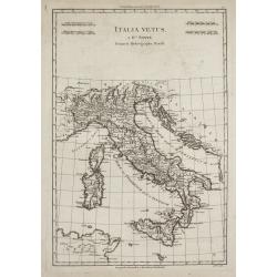
Italia Vetus
Rigobert Bonne (1727-1795), French cartographer. His maps are found in a.o. Atlas Moderne (1762), Raynal's Histoire Philos. du Commerce des Indes (1774) and Atlas Encyclo...
Date: Paris, 1787-1788
Selling price: ????
Please login to see price!
Sold

Select Views in Great Britain. Engraved by S. Middiman, from Pictures and Drawings by the most eminent Artists. With descriptions
36 engraved plates by Samuel Middiman. Between the plates a text leave with french and english description. Plates are dated 1784 - 1788. Copper-engraved calligraphic tit...
Date: London, 1788
Selling price: ????
Please login to see price!
Sold in 2009
Kriegstheater oder graenzkarte Oestereichs, Russland,. . .
Uncommon map of the northern part of Turkey, Sea of Marmora, Black Sea, Hungary, Bosnia, Serbia and Caucasus.The map is in contemp. color, each color indicating the posse...
Date: Vienna, 1788
Selling price: ????
Please login to see price!
Sold in 2009
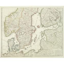
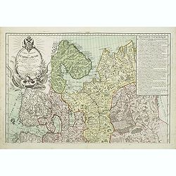
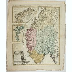
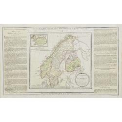
Carte des Courones du Nord comprenant la Suede, le Danemarc, &c. . .(2 maps)
Large and detailed map of Scandinavia after de l´Isle, G. It shows Norway, Sweden, Finland, Denmark and part of Russia.With a brilliant figurative armorial cartouche. 2-...
Date: Paris, 1788
Selling price: ????
Please login to see price!
Sold in 2018
Carte générale de l'Empire de Russie comprise en Europe, pour l'intelligence de la guerre présente entre l'Impératrice de toutes les Russies et le Turc. . .
Uncommon and detailed map of the northern part of European Russia, Finland and Lapland with an ornamental title cartouche in the upper left corner. Prepared by Maurille A...
Date: Paris, 1788
Selling price: ????
Please login to see price!
Sold in 2011
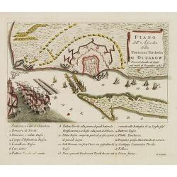
Piano dell'Assedio della Fortezza Turchesca di Oczakow : presa d'Assalto da' Russi nel mese di Decembre 1788.
Plan of Ochakiv (Ukraine) published by Antonio Zatta. Below the engraving (151x243mm.) is a numbered key, 1-19 showing the points of interest to this siege of Ochavik by ...
Date: Venice, after 1788
Selling price: ????
Please login to see price!
Sold in 2012
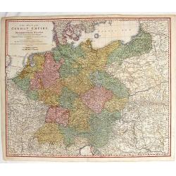
A New Map of Germany and Its Neighbouring States.
Large, detailed map of Germany and portions of Poland, Hungary, Denmark and Italy. It was originally published by the Royal Academy of Berlin. William Faden (1750 - 1836...
Date: London, c1788
Selling price: ????
Please login to see price!
Sold in 2014
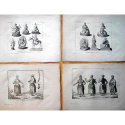
Set of 9 plates from \"Voyage de Pallas\".
An interesting collection of nine rare copper engraved plates with Russian and Mongolian people, gods, and costumes. Engraved by N. Thomas: "Femmes Mordouanes d...
Date: Paris, c1788
Selling price: ????
Please login to see price!
Sold in 2013
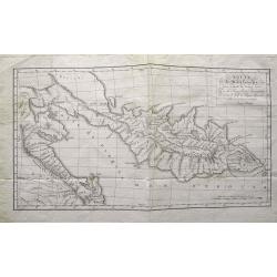
Route de M. de Lesseps,... dans la presqu\'île de Kamtschatka...
Rare and important map of Kamchatka. Shows the Peninsula with new discoveries. Many place names and rivers named. Jean-Baptiste Barthélemy de Lesseps was a translator o...
Date: Paris, c1788
Selling price: ????
Please login to see price!
Sold in 2015
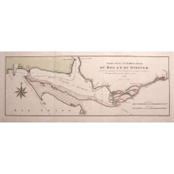
Confluent et Embouchure du Bog et du Dniéper. . .
Rare chart of the mouth of the Dnieper River into the Black Sea. Locates Kherson (Cherson) and Otchakof (Ochakiv). With many depth soundings.We were unable to identify th...
Date: Vienna, 1788
Selling price: ????
Please login to see price!
Sold in 2015
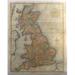
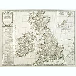
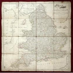
A New and Correct Map of Great Britain from the Most Accurate Surveys.
Map of England, Scotland and Wales with the individual counties named and outlined. Hadrian's Wall & Severus Wall are shown but not labeled.Thomas Bowen (died 1790) w...
Date: London, 1788
Selling price: ????
Please login to see price!
Sold in 2016
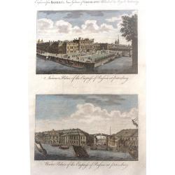
Summer Palace of the Empress of Russia at Petersburg and Winter Palace of the Empress of Russia at Petersburg
Two beautiul Russian scenes - "Summer Palace of the Empress of Russia at Petersburg" and "Winter Palace of the Empress of Russia at Petersburg", by an...
Date: London, 1788
Selling price: ????
Please login to see price!
Sold in 2017
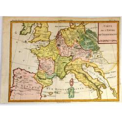
Carte de l'Empire de Charlemagne.
Striking decorative copper engraved French edition map of the European Continent at the time of the Emperor Charlemagne. Cannot find this exact map on the Internet.
Date: Paris, 1788
Selling price: ????
Please login to see price!
Sold in 2017

A Map of Hertfordshire, Engraved from an Actual Survey, with Improvements.
An uncommon late eighteenth-century map of the county - neatly engraved by Edward Sudlow (1784-1793). Originally produced as one of John Harrison's series of maps publish...
Date: London, 1788
Selling price: ????
Please login to see price!
Sold in 2016
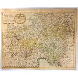
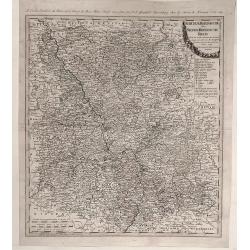
Der Oesterreichische Kreis.
The map shows the ancient Austrian Empire with the Duchy of Austria, Styria, KŠrnten, Krain (Slowenia) Istria, Tyrol, and diocese Trient. In 1716, Homann published his m...
Date: Nuremberg, 1788
Selling price: ????
Please login to see price!
Sold in 2016
![[2 sheets] Carte de Moscovie...](/uploads/cache/38419-250x250.jpg)
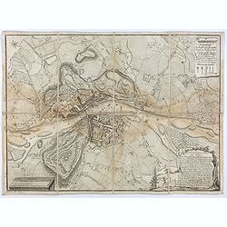
[2 sheets] Carte de Moscovie...
Dezauche's large two sheet map, based on the earlier map by de Lisle, of western Russia from Lapland, and the White sea in the north, to the Sea of Azov, and the Crimea i...
Date: Amsterdam, ca. 1788
Selling price: ????
Please login to see price!
Sold in 2017
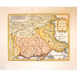
Plan de la Baye d'Awatska sur la Cote du Kamschatka
An interesting map of several countries along the east coast of Asia.
Date: Paris, 1788
Selling price: ????
Please login to see price!
Sold in 2020
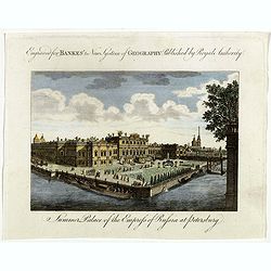
Summer Palace of the Empress of Russia at Petersburg.
Showing the "Summer Palace of the Empress of Russia at Petersburg". Published in Thomas Bankes's “New System of Universal Geography”
Date: London, 1788
Selling price: ????
Please login to see price!
Sold in 2018
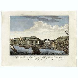
Winter Palace of the Empress of Russia at Petersburg.
Showing the "Winter Palace of the Empress of Russia at Petersburg". Published in Thomas Bankes's “New System of Universal Geography”.
Date: London, 1788
Selling price: ????
Please login to see price!
Sold in 2018
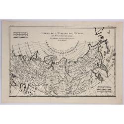
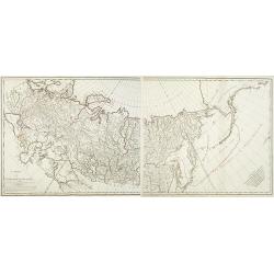
Carte de L'Empire de Russie.
A fine map of the empire of Russia by Bonne published in Paris in 1788. It embraced both Russia in Europe and Russia in Asia. Rigobert Bonne (1727-1795) was one of the mo...
Date: Paris, 1788
Selling price: ????
Please login to see price!
Sold in 2019
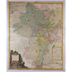
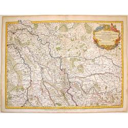
Der Rhein Die Maass und Mosel mit den anliegenden Landern des Ober-Chur und Neider-Rhein. . .
A fine, detailed Johann Baptist Homann's map of the Maass and Moselle areas of the Rhine with the adjoining lands of the Upper Chur and the Neider-Rhine. This map feature...
Date: Nuremberg, 1788
Selling price: ????
Please login to see price!
Sold in 2018
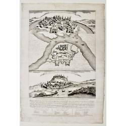
Descrizione della fortezza, e città di Belgrado.
Scarce publication printed just before the Austrian attack to Beograde in 1789. The print is divide in three parts called « Prospetto della fortezza e parte della città...
Date: Venice, 1788
Selling price: ????
Please login to see price!
Sold in 2019
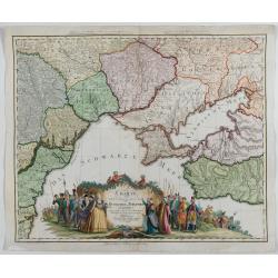
Charte von den oberhalb und seitwärts dem Schwarzen Meere gelegenen Russischen und Türkischen Ländern …
Very rare and detailed map of the black sea region, including parts of Ukraine, Turkey and Poland. In the lower part, a color key. Beautiful tittle cartouche with Empress...
Date: Berlin, 1788
Selling price: ????
Please login to see price!
Sold in 2023
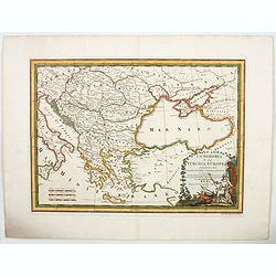
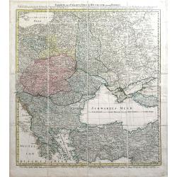
L'Ungheria e la Turchia Europea. . .
Cassini's beautiful map of Greece and the Balkans, but also including parts of Germany, today's Ukraine and Italy. It shows the eastern Mediterranean, the Gulf of Venice ...
Date: Rome, 1788
Selling price: ????
Please login to see price!
Sold in 2023
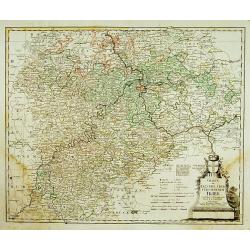
Charte das Erzstift u. Churfürstenthum Trier. . .
Centered on Trier. Prepared by F.L.Güssefeld. °
Date: Nuremberg, 1789
Selling price: ????
Please login to see price!
Sold in 2011
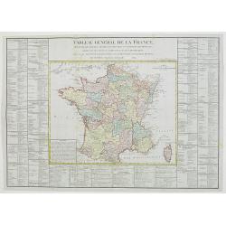
Tableau général de la France,..
Uncommon map of France, with inset map of Corsica. Surrounded by geographical information for each department along with useful statistical information.Prepared by Louis ...
Date: Paris, 1789
Selling price: ????
Please login to see price!
Sold in 2012
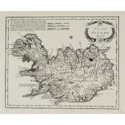
Die Insel Island Nro. 76.
An attractive map of Iceland based on the unpublished Knoff survey. The map locates villages and churches and graphically delineates the mountains, rivers, lakes and fore...
Date: Vienna, 1789
Selling price: ????
Please login to see price!
Sold in 2016
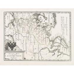
General = Karte von dem Russischen Reiche in Europa Nr. 60
Map of the European part of Russia, with a nice representation of coat of arms. Published by Franz Johann Joseph von Reilly, 1766-1820, who was a Viennese art dealer who ...
Date: Vienna, 1789
Selling price: ????
Please login to see price!
Sold in 2009
Carte générale des bureaux et ténances des Postes des Pays- Bas Autrichiens: dediée à Son Altesse Monseigneur Charles-Anselme, Prince de la Tour et Tassis et du St Empire, . . .
Postal route map of present-day Belgium and Dutch Brabant during Austrian occupation, prepared by Jean Baptiste de Bouge (1757-1833). Engraved by Philippe-Joseph Maillart...
Date: Brussels, 1789
Selling price: ????
Please login to see price!
Sold in 2013
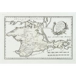
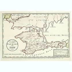
Special karte von dem königreiche Taurien oder der Haldinsel Krim. Nro. 61.
Clear engraving of Crimea, from Reilly's Postal Atlas, 1791. Including the cities of Praghtschisarai, Theodosia. The post road mapspost routes are indicated.
Date: Vienna, 1789
Selling price: ????
Please login to see price!
Sold in 2018
Carte de l'Empire de Russie. (2 maps)
Detailed map of Russia in two sheets, published at the outbreak of the French Revolution. Taken from the Atlas Géographique, published by Jean-Claude Dezauche (active 17...
Date: Paris, c. 1789
Selling price: ????
Please login to see price!
Sold in 2014
Schauplatz des Türkenkriegs von MDCCLXXXIX.
Map showing the region of the east of Europe including Crimea, Romania, Moldova, Hungary, Serbia. Nice cartouche, rare map.
Date: Germany, 1789
Selling price: ????
Please login to see price!
Sold in 2010
Charte von Ungarn Polen, Russland und der Turkey...
Exceptional folding map of Eastern Europe including the Black Sea published by the Schneider-Weigel firm in Nuremberg, Germany. Includes the countries of Greece, Bulgaria...
Date: Nuremberg, 1789
Selling price: ????
Please login to see price!
Sold in 2010
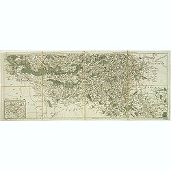
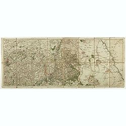
Nouvelle carte chorographique des Pays-Bas autrichiens.
COMPLETE Wall map of the Southern Low Countries (or Austrian Netherlands) published in 1789, composed of 16 leaves, each map ca. 320x395mm. and bound together.First map w...
Date: Bruxelles, 1789
Selling price: ????
Please login to see price!
Sold
Carte des isles britanniques. . .
A charming map of England, based on a map of Thomas Kitchin. Published by Charles François Delamarche (1740-1817). As successor to the great DeVaugondy, the French publi...
Date: Paris, 1789
Selling price: ????
Please login to see price!
Sold in 2011
Les environs de Neufchateau, Virton, Montmedy. . .Les environs de Luxembourg, Arlon, Thionville.
Map of the east of France and Luxembourg.The map was prepared by Jean Baptiste de Bouge (1757-1833), who prepared one of the first very detailed maps of Belgium.Map 7 and...
Date: Bruxelles, 1789
Selling price: ????
Please login to see price!
Sold in 2012
Schauplatz des Türkenkriegs von MDCCLXXXIX.
Map showing the War scene region if the east of Europe including Crimea, Romania, Moldova, Hungary, Serbia during the year 1789 when the Austrians capture Belgrade from t...
Date: Austria, ca.1789
Selling price: ????
Please login to see price!
Sold in 2012
Teatro Della Guerra Nel Nord Tra La Russia, Svezia E Danimarca.
A large map of Scandinavia with the title contained within a martial cartouche. The war the map title refers to was waged from 1788-1790 between Russia and Sweden which e...
Date: Venice, 1789
Selling price: ????
Please login to see price!
Sold in 2012
The Traveller's Companion or the Post roads of England and Wales: With the Distances in Measured Miles By the late John Rocque Chorographer to the King and it is laid on linen in sixteen sections.
Linen-backed folding map of England and Wales by John Rocque published by Robert Sayer of No 53 Fleet Street London. This map is the Robert Sayer published map of 1789 no...
Date: London, 1789
Selling price: ????
Please login to see price!
Sold in 2013
Die Landschaft Romanien, No 16.
Detailed copperplate map featuring parts of Turkey and Southern Bulgaria. Included is Constantinopel. Joseph von Reilly (1766 – 1820) was a Viennese art dealer who tu...
Date: Vienna, 1789
Selling price: ????
Please login to see price!
Sold in 2016
Les Duches de Cleves de Juliers, de Limbourg.
Striking large copper engraved map featuring Rhineland Germany and the Netherlands. Very decorative, large, figural cartouche. Detailed presentation of cities, towns, riv...
Date: Paris, 1789
Selling price: ????
Please login to see price!
Sold in 2016
Post Karte von der Halbinsel Taurien oder Krim 1788.
Detailed map of the Crimean Island. Prepared by François Joseph Maire (Vienna, 1738 - c.1800). F.J. Maire was a publisher, geographer and engineer active in Vienna. He p...
Date: Vienna, 1788-1789
Selling price: ????
Please login to see price!
Sold in 2014
Carte de la partie d'Albanie occupée par le Bacha de Scutari. . . - Karte des Theils von Albanien so der Bascha von Scutari in besitze hat. . .
Detailed map of Albania. Prepared by François Joseph Maire (Vienna, 1738 - c.1800). F.J. Maire was a publisher, geographer and engineer active in Vienna. He published so...
Date: Vienna, 1788-1789
Selling price: ????
Please login to see price!
Sold in 2014
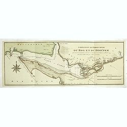
Confluent et embouchure du Bog et du Dniéper.
Detailed map of the mouth of the river Dnieper and the Black Sea, with border lines for the year 1787 and 1788 during the Russian, Turkish War. Prepared by François Jose...
Date: Vienna, 1788-1789
Selling price: ????
Please login to see price!
Sold in 2014
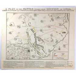
A PLAN OF THE BATTLE NEAR Fought Leuthen OR LISSA, / in SILESIA; the 5th. of December 1757. in Which his PRUSSIAN MAJESTY gained a compleat Victory over the AUSTRIAN Army Commanded by Prince Charles of Lorrain.
A plan the battle of Leuthen, between the Prussian troops, under the command of Friedrich II, and the Austrian troops under the command of Charles of Lorraine on December...
Date: The Hague, 1789
Selling price: ????
Please login to see price!
Sold in 2016
A Map of the Principal Roman Camps, Forts, Walls & c. Between the River Tyne in England and Tay in Scotland.
An antique county map published in "Britannia : or, a Chorographical Description of the flourishing kingdoms of England, Scotland and Ireland" by William Camden...
Date: London, 1789
Selling price: ????
Please login to see price!
Sold in 2016
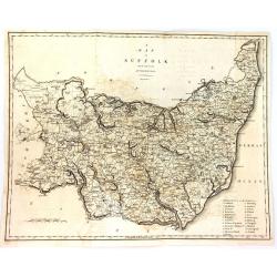
A Map of Suffolk from the Best Authorities.
An attractive and detailed late 18th century map of Suffolk engraved by John Cary and published in Richard Gough's new translation of Camden's Britannia (London: 1789). J...
Date: London, 1789
Selling price: ????
Please login to see price!
Sold in 2016
A General Map of the Roman or Picts Walls with the Adjacent Country including the Stations per Lineam Valli
A general Map of the Roman or Picts Walls, (Hadrian's Wall) in Cumberland and Northumberland, and Scotland. Engraved by John Cary for Richard Gough in London around 1789....
Date: London, 1789
Selling price: ????
Please login to see price!
Sold in 2018
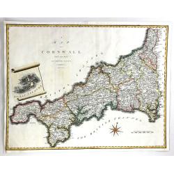
A Map of Cornwall from the Best Authorities
A fine map of Cornwall, in England by John Cary. Published in 'Camden's Britannia' in 1789. Interesting scroll insert featuring the Scilly Islands, with a fancy compass r...
Date: London, 1789
Selling price: ????
Please login to see price!
Sold in 2016
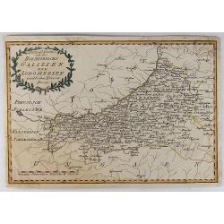
Spezial Karte von des Koenigreichs Galizien und Lodomerien Westlichen Kreisen.
Special Map of the Kingdoms of Galicia and Lodinerien on the border between Poland and Hungary. By Franz von Reilly in 1791. It features a decorative laurel title carto...
Date: Vienna, 1789
Selling price: ????
Please login to see price!
Sold in 2018
Les environs de Louvain..., Les environs de Limbourg, Rolduc,. . .
Showing the cities of Louvain, Liege, Aix la Chapelle, Cologne. . . The map was prepared by Jean Baptiste de Bouge (1757-1833), who prepared one of the first very detaile...
Date: Bruxelles, 1789
Selling price: ????
Please login to see price!
Sold in 2017
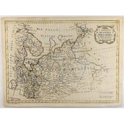
I Governi D'Arcangelo e Bielo-Ozero. . .
An unusual Vincenzo Pazzini Carli's copper engraved map of northern part of Russia in Europe, published in 1789. The map is filled with excellent topographic detail and ...
Date: Rome, 1789
Selling price: ????
Please login to see price!
Sold in 2021
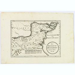
Des Koenigreichs Bulgarien. . .
Von Reilly's map of eastern Bulgaria as it was toward the end of the eighteenth century from the river Danube to the Black Sea. Shows rivers, mountains, larger cities and...
Date: Vienna, 1789
Selling price: ????
Please login to see price!
Sold in 2021
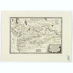
Des Russischen Reiches Statthalterschaften Pleskow, Polozk, Mohilew, Twer, Moskau, Koluga, Wolodimer, Iaroslaw, Tula, Smo, Lensko und Nischgorod. Nro.64
A map of the European part of Russia, that is centered on Moscow. Published by Franz Johann Joseph von Reilly, (1766-1820), who was a Viennese art dealer, who turned to m...
Date: Vienna, 1789
Selling price: ????
Please login to see price!
Sold in 2021
Der Chur Rheinische oder Neider Rheinische Kreis.
Fine detailed 1789 Homann Heir’s map of the lower Rhine circle with the electorates of Mainz, Trier and Cologne. Features a garland style title cartouche. Johann Bapt...
Date: Nuremberg, 1789
Selling price: ????
Please login to see price!
Sold in 2020
Grundriss der hochfürst. - erzbischöfliche Haupt und Residenz Stadt Salzburg im Jahr 1789 / geometrisch aufgenommen u. gezeichnet von A. F. H. v. Naumann
Uncommon plan of Salzburg as in the year 1789, drawn by A. F. H. Naumann. Engraved by Ch. T. C. Wirsnig.
Date: Salzburg, 1789
Selling price: ????
Please login to see price!
Sold in 2021
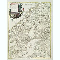
Charte vom Konigreich Norwegen . . .
Decorative map of Kingdom of Norway and the Faroe Islands (Faroese map inserted by C.G. Mengel). According to O.A.Wangensteens and some other charts of the Büschingian g...
Date: Nurenberg, 1789
Selling price: ????
Please login to see price!
Sold in 2022
Pays Bas françois et Autrichien..
Map of Belgium. With on verso a chart showing the coasts of the French Channel.Louis Capitaine (1749-1797) worked with Belleyme and Chanlaire on Topographical maps of Fra...
Date: Paris ca.1790
Selling price: ????
Please login to see price!
Sold
L' Italie Divisée en tous ses Etats..
Decorative map of Italy, showing Corsica and Sardinia. With ornamental title cartouche and inset map of the Mediterranean including Tunis, Malta and Pantelleria.Flanked b...
Date: Paris, 1790
Selling price: ????
Please login to see price!
Sold
La Suede, et la Norwege Avec l'Islande..
Finely engraved map of Scandinavia, with inset map of Iceland in the upper left and decorative title cartouche.The map is flanked by two columns of French text containing...
Date: Paris, 1790
Selling price: ????
Please login to see price!
Sold in 2010

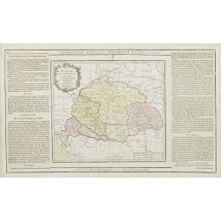
La Russie Européenne Conformément à l'Atlas de cet Empire. . .
Attractive map of the European part of Russia. Decorated with a title cartouche in the lower left corner.The map is flanked by two columns of French text containing geogr...
Date: Paris, 1790
Selling price: ????
Please login to see price!
Sold in 2009
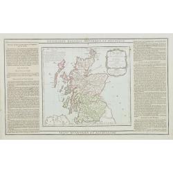
L'Ecosse..
Decorative map showing Scotland divided into northern and southern portions with all the county divisions noted. Embellished with fine title cartouche.The map is flanked ...
Date: Paris, 1790
Selling price: ????
Please login to see price!
Sold
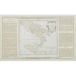
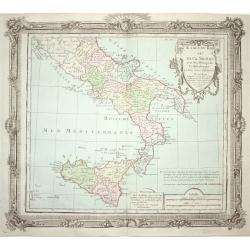
Etats du Roi des Deux Siciles avec les Métropoles Ecclésiastiques et tous leurs Suffragans..
Attractive map of southern Italy and Sicily with ornamental rococo-style title cartouche.The map is flanked by two columns of French text containing geographical informat...
Date: Paris, 1790
Selling price: ????
Please login to see price!
Sold in 2023
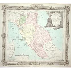
Etats de l' Eglise, de Toscane, Modène et Luques..
Decorative map of Italy covering the region centered on Florence and extending to show Modena, Bologna and Rome.With major cities of the area named among which Siena, Are...
Date: Paris, 1790
Selling price: ????
Please login to see price!
Sold
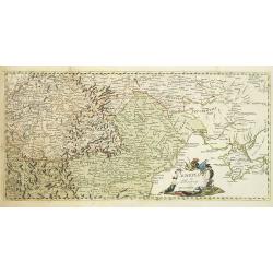
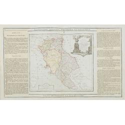
La Hongrie avec les Provinces adjacentes. . .
Attractive map of Hungary, adorned with a rococo-style title cartouche.Left and right box with geographical information about the area. Printed on 2 paste-on slips.Prepar...
Date: Paris, 1790
Selling price: ????
Please login to see price!
Sold in 2009
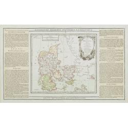
Le Danemark divisé par Provinces et Dioceses sous une Métropole..
Finely engraved map of Denmark, extending eastwards to show all islands including Bornholm. Decorative rococo-style cartouche.Left and right box with geographical informa...
Date: Paris, 1790
Selling price: ????
Please login to see price!
Sold
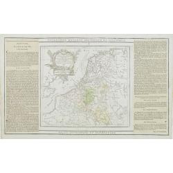
Les Pays Bas Francois Autrichiens, et Hollandois, Divisee en Provinces Civiles et Esslesiastiques..
A decorative copper engraved map of Benelux which extends to include portions of France and Germany. Decorative rococo-style cartouche.Left and right box with geographica...
Date: Paris, 1790
Selling price: ????
Please login to see price!
Sold in 2008
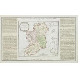
L'Irlande divisée..
Map showing Ireland, decorated with a rococo-style cartouche. Left and right a box with geographical information in French about the country (rivers, counties etc.). Prin...
Date: Paris, 1790
Selling price: ????
Please login to see price!
Sold
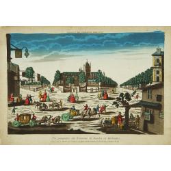
Vue perspective des Environs de Leyden en Holande.
Attractive print of the Pieterskerk in the center of Leiden.J. Chereau was a publisher of optical prints, established in Paris, rue St.Jacques. In the eighteenth and nine...
Date: Paris 1790
Selling price: ????
Please login to see price!
Sold
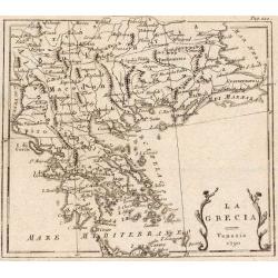
La Turchia d. Europa.
A small map depicting Greece and the Balkan, from the Italian edition of Claude Buffier's ' Geographie Universelle'.
Date: Venice, 1790
Selling price: ????
Please login to see price!
Sold
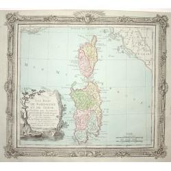
Les Isles de Sardaigne et de Corse..
Attractive copper engraved map of Corsica and Sardinia with Rome at extreme left. Good detail throughout including villages, rivers, and coastlines. Decorated with a nice...
Date: Paris 1790
Selling price: ????
Please login to see price!
Sold
Etats de l' Eglise, de Toscane, Modene et Luques..
Decorative map covering the region centered on Florence and extending to show Rome and Modena. Decorative cartouche and rococo style border.
Date: Paris 1790
Selling price: ????
Please login to see price!
Sold
Estats du Roi des Duex Siciles..
Attractive map of southern Italy and Sicily. Decorative rococo-style cartouche and surrounding border that was printed from a separate copper plate.
Date: Paris 1790
Selling price: ????
Please login to see price!
Sold
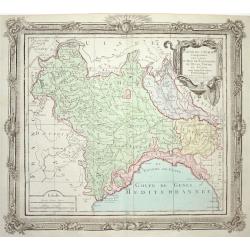
Partie de l' Italie Comprenant les Etats du Roy de Sardaigne
Attractive map of northwest Italy and the Golfo di Genova. Adorned with a very nice title cartouche and enclosed in a rococo-style border.
Date: Paris 1790
Selling price: ????
Please login to see price!
Sold