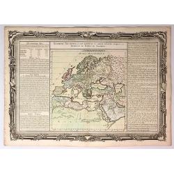
Browse Listings in Europe
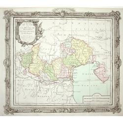
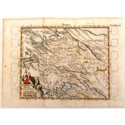
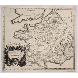
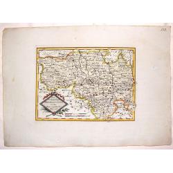
L' Etat de Venise et le Duche de Mantoue
Nice map covering the region centered on Venice and extending to include Modena and Bologne, and eastward to Trieste and Istria. Decorated with a fine title cartouche and...
Date: Paris 1790
Selling price: ????
Please login to see price!
Sold
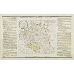
Etats de Pologne et de Lithuanie..
Handsome map of Poland and Lithuania with decorative title cartouche.The map is flanked by two columns of French text containing geographical information about the area. ...
Date: Paris, 1790
Selling price: ????
Please login to see price!
Sold
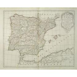
Carte de l'Espagne Dressée par Guillaume Delisle sur la description de Rodrigo Mendez Sylva . . . Le tout augmenté et vérifié en 1765 Par Phil. Buache, de l'Académie des Sciences.
Map of Spain and Portugal, including the North African coast and good detail for Majorca, Minorca and Ibiza. Taken from the Atlas Géographique.. published by Dezauche, a...
Date: Paris, c.1790
Selling price: ????
Please login to see price!
Sold in 2022
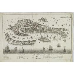
La Citta di Venezia.
Uncommon and decorative plan of Venice.
Date: Italy, ca. 1790
Selling price: ????
Please login to see price!
Sold in 2009
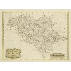
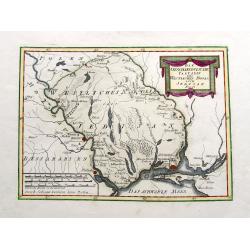
La Wolhynia e la Podolia divise ne' loro Palatinati.
From "Atlante geografico" by Bartolomeo Borghi (1750-1821), published in Sienna 1788-1800.
Date: Siena, Presso Pazzini Carli, 1790
Selling price: ????
Please login to see price!
Sold in 2010
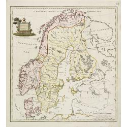
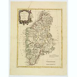
Present Sweden & Norway.
Charming map of Scandinavia, with some detail in Sweden, Norway and Finland. Engraved by Samuel John Neele. (1758-1824) and published by Thomas Stackhouse (1756-1836)
Date: London, T.Stackhouse, 1790
Selling price: ????
Please login to see price!
Sold in 2010
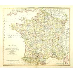
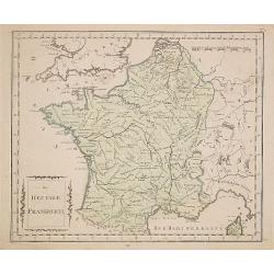
France divided into Metropolitan circles departments & districts.
Map of France with an inset of Corsica in the same scale. William Faden (1750?-1836) was Geographer to His Majesty and to H.R.H. the Prince of Wales.
Date: London, 1790
Selling price: ????
Please login to see price!
Sold in 2010
Carte des marches du quartier générale de l'Armée Rusienne fait sous le Commandement de S.E. Le Feld Marechal Comte de Butturlin. . .
Manuscript map of Poland showing the campaign of Marshal Butterlin in 1761 at the conclusion of the "Seven-year's War" (1756 - 1763). To the right an almost dai...
Date: France, c.1761-1790
Selling price: ????
Please login to see price!
Sold in 2014
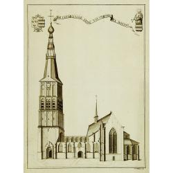
De collegiaale kerk van St.Pieter te Boxtel.
Rare print of St. Pieter church in Boxtel.
Date: Netherlands, c.1790
Selling price: ????
Please login to see price!
Sold in 2011
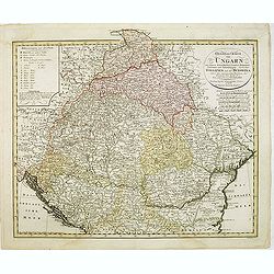
General Charte von Ungarn :mit seinem Nebenländern Croatien, Dalmatien, Slavonien und Siebenbürgen, ingleichen Gallizien und der Bukowina nebst. . .
Map of Hungary prepared by F. L. Güssefeld and published by Homann Heirs. Engraved by I. Rausch.
Date: Nuremberg, 1790
Selling price: ????
Please login to see price!
Sold in 2012
![[No tittle - With Russian text] Poland and the Baltic Sea.](/uploads/cache/31405-250x250.jpg)
[No tittle - With Russian text] Poland and the Baltic Sea.
Detailed map of Poland after Rizzi-Zanoni's map of 1783 here in Russian. The map was prepared by the Italian astronomer, geographer and cartographer Giovanni Antonio Rizz...
Date: mperial Academy of St. Petersburg, ca. 1790
Selling price: ????
Please login to see price!
Sold in 2012
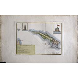
Plan de Kronstadt.
Map shows a city map of Kronstadt.
Date: Paris, 1790
Selling price: ????
Please login to see price!
Sold in 2014
L'Imperio Della Gran Russia.
Striking and highly detailed unusual copper engraved map of the European Russian empire. The map provides several topographic details concerning cities, towns, rivers, la...
Date: Paris, 1790
Selling price: ????
Please login to see price!
Sold in 2015
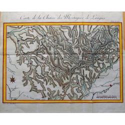
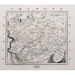
Carte de la Chaine des Montagnes de Langres.
Unusual map an area in North-East France, including the cities of Sens, Troyes, Bar-sur-Aube, Chaumont, Neufchateau, Langres, Gray, Besancon, Dijon, Auxerre. Great detail...
Date: Paris, c1790
Selling price: ????
Please login to see price!
Sold in 2015

Vue Interieure de la Cathedrale de Dorth. (Dordrecht)
Optical view of an interior view of the Cathedral of Dordrecht. So-called Optical view enhanced by water colors. It was produced by Daumont in Paris in about 1790. The op...
Date: Paris, 1790
Selling price: ????
Please login to see price!
Sold in 2018
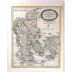
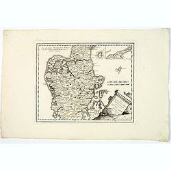
Il Regno Di Danimarca.
A rare map of Denmark, published by Pazzini Carli in Siena. Engraved by A. Borghi. With a lovely quaint, oval, floral, cartouche.
Date: Siena, 1790
Selling price: ????
Please login to see price!
Sold in 2018
Mappa gubernii Orelensis.
Highly detailed rare map covering the area of the Oryol Oblast in Russia, south of Moscow.The map is a result of a new survey of Russia done in the first years of the rei...
Date: St Petersburg, 1750-1790
Selling price: ????
Please login to see price!
Sold in 2016
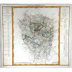
Departement de Paris & Departement de la Seine et de la L'Oise
A fine map featuring the area of France surrounding Paris. From the "Atlas National de France" by Pierre Dumez (1757-1794). The map has a detailed index on both...
Date: Paris, 1790
Selling price: ????
Please login to see price!
Sold in 2016
![[Map including Wroclaw and region].](/uploads/cache/38706-250x250.jpg)
[Map including Wroclaw and region].
A very detailed of region of Wroclaw (Breslau) from Roch Joseph Julien's "NOUVEAU THEATRE DE LA GUERRE OU ATLAS TOPOGRAPHIQUE ET MILITAIRE" published in 1758 in...
Date: 1790
Selling price: ????
Please login to see price!
Sold in 2016
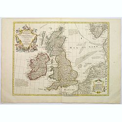
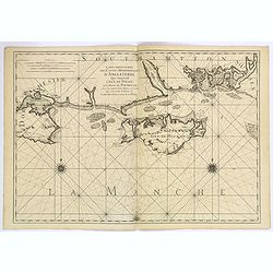
Les Isles Britanniques ou sont le Rme. D'Angleterre . . . Par G. De L'Isle. . . A Paris Chez Dezauche. . .
An uncommon, but attractive map of the British Isles. The bottom right shows the coasts of the Netherlands, Belgium, and northern France and at the upper right is the sou...
Date: Paris, c.1790
Selling price: ????
Please login to see price!
Sold in 2017
![SHVETZIJA I NORVEGIJA [russian Map !]](/uploads/cache/97961-250x250.jpg)
SHVETZIJA I NORVEGIJA [russian Map !]
A copperplate Russian map of Sweden, Norway and Finland with original outline coloring, ca 1790.
Date: St. Petersburg, 1790
Selling price: ????
Please login to see price!
Sold in 2019
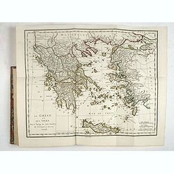
Recueil de Cartes Geographiques, Plans, Vues et Medailles de L'Ancienne Grece, Relatifs Au Voyage du Jeune Anacharsis, Precede d'une Analyse Critique des Cartes.
Great atlas of Ancient Greece, including many classical maps and battle plans. 31 copper engraved maps plans and plates with several hand colored in outline, many double ...
Date: Paris, 1790
Selling price: ????
Please login to see price!
Sold in 2017
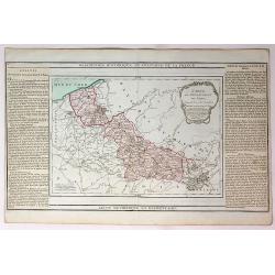
Carte du Departement du Nord.
An attractive map of the department of Nord in northern France by French cartographer, Louis Brion de la Tour. It notes numerous towns, cities, rivers, forests, mountains...
Date: Paris, 1790
Selling price: ????
Please login to see price!
Sold in 2017
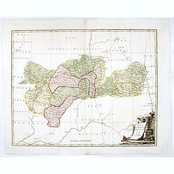
Carte D'Austriche Divisee en Toutes ses Provinces...
An attractive and informative map of Austria by French cartographer, Louis Brion de la Tour. It notes numerous towns, cities, rivers, forests, mountains and other topogra...
Date: Paris, 1790
Selling price: ????
Please login to see price!
Sold in 2018
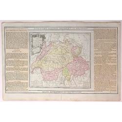
La Suisse Divisee en Toutes ses Cantons.
An attractive and informative map of Switzerland by French cartographer, Louis Brion de la Tour. It notes numerous towns, cities, rivers, forests, mountains and other top...
Date: Paris, 1790
Selling price: ????
Please login to see price!
Sold in 2018
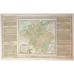
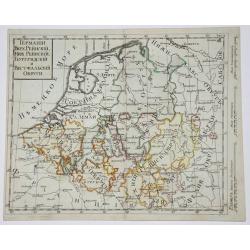
L'Alemagne Divisee en Tous ses Cercles...
An attractive and informative map of Germany by French cartographer, Louis Brion de la Tour. It notes numerous towns, cities, rivers, forests, mountains and other topogra...
Date: Paris, 1790
Selling price: ????
Please login to see price!
Sold in 2018
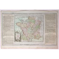
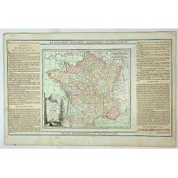
La France, Divisee en ses Quarante Gouvernemens Generaux et Militaires...
An attractive and informative map of France by French cartographer, Louis Brion de la Tour. It notes numerous towns, cities, rivers, forests, mountains and other topograp...
Date: Paris, 1790
Selling price: ????
Please login to see price!
Sold in 2019
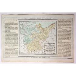
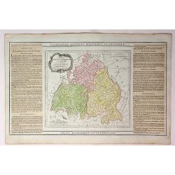
Cercles de Haute wt Basse Saxe,Divises en Toutes Leurs Principantes et Provinces...
An attractive and informative map of France by French cartographer, Louis Brion de la Tour. It notes numerous towns, cities, rivers, forests, mountains and other topograp...
Date: Paris, 1790
Selling price: ????
Please login to see price!
Sold in 2019
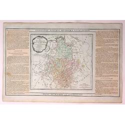
Cercles de Baviere de Franconie et de Souabe...
An attractive and informative map of France by French cartographer, Louis Brion de la Tour. It notes numerous towns, cities, rivers, forests, mountains and other topograp...
Date: Paris, 1790
Selling price: ????
Please login to see price!
Sold in 2018
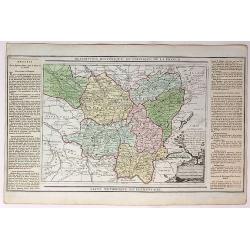
Cercles de Westphalie Haut et Bas Rhin Divises en Toutes Leurs Principautes et Provinces...
An attractive and informative map of Westphalia by French cartographer, Louis Brion de la Tour. It notes numerous towns, cities, rivers, forests, mountains and other topo...
Date: Paris, 1790
Selling price: ????
Please login to see price!
Sold in 2019
Carte des Departemens de la Meuse, de la Moselle, de la Meurte, des Voges et du Bas Rhin...
An attractive and informative map of departments in France by French cartographer, Louis Brion de la Tour. It notes numerous towns, cities, rivers, forests, mountains and...
Date: Paris, 1790
Selling price: ????
Please login to see price!
Sold in 2018
Carte des Departemens de la Cote d'Or, de Daone et Loire, de la HauteSaone, du Doubs de Jura.....
An attractive and informative map of French departments by French cartographer, Louis Brion de la Tour. It notes numerous towns, cities, rivers, forests, mountains and ot...
Date: Paris, 1790
Selling price: ????
Please login to see price!
Sold in 2019
Quatrieme Age Depuis la Loy Ecrite ou la Sortie D'Egypte Jusqu'a la Dedicace du Temple de Salomon.
An attractive and informative map of the exit from Egypt, to the dedication of Solomon, by French cartographer, Louis Brion de la Tour. To the left and right of the map a...
Date: Paris, 1790
Selling price: ????
Please login to see price!
Sold in 2017
Belgium, Netherlands, Luxemburg.
Copperplate in Russian language of The Netherlands, Belgium and Luxembourg with original outline coloring. Part of Netherlands and Luxembourg are parts of Austria.
Date: St. Petersburg, 1790
Selling price: ????
Please login to see price!
Sold in 2017
West Germany & Belgium, Luxemburg.
Copperplate russian map of West Germany & Belgium, Luxemburg. with original outline coloring.
Date: St. Petersburg, 1790
Selling price: ????
Please login to see price!
Sold in 2017
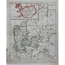
DANIJA I ISLANDIJA, (Russian map).
A copperplate Russian map of Denmark and Iceland, with original outline coloring, published in 1790.
Date: St. Petersburg, 1790
Selling price: ????
Please login to see price!
Sold in 2017
Die Markgrafschaft des heiligen römischen Reichs Antwerpen mit der Herrschaft Mecheln.
A detailed large scale map of the area with Antwerp, Lier, Herentals, Geel, Mol, Turnhouta, Hoogstraten, etc. Shows many small towns.
Date: Vienna, ca. 1790
Selling price: ????
Please login to see price!
Sold in 2018
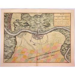
Plan van de Veldtslag van Zenta.
A map of the fortifications and surrounding area of troop orders during the battle of Senta in 1697, between the Imperial and Turkish troops .The birds-eye plan is from J...
Date: Paris, ca. 1790
Selling price: ????
Please login to see price!
Sold in 2018
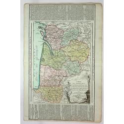
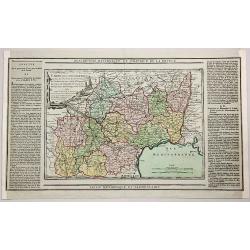
Carte des Departemens de la Mayenne, de la Sarte, D'Eure et Loire, de maine et Loire, d'Indre et de Loire....
An attractive and informative map of several provinces by French cartographer Louis Brion de la Tour. It notes numerous towns, cities, rivers, forests, mountains, and oth...
Date: Paris, 1790
Selling price: ????
Please login to see price!
Sold in 2019
Les Pays Bad Francois Autrichiens et Hollandois...
An attractive and informative map of Holland by French cartographer, Louis Brion de la Tour. It notes numerous towns, cities, rivers, forests, mountains and other topogra...
Date: Paris, 1790
Selling price: ????
Please login to see price!
Sold in 2018
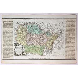
Carte des Departemens de la Charente Inferieure, de la Charente, de la Gironde, de la Dordogne, des Landes, du Lot et Garonne et des Baffes Pyrenees...
An attractive and informative map several French Provinces by French cartographer, Louis Brion de la Tour. It notes numerous towns, cities, rivers, forests, mountains an...
Date: Paris, 1790
Selling price: ????
Please login to see price!
Sold in 2019
La France Divisee en ses Quarante Gouvernemens Generaux et Militaires...
An attractive and informative map of the governmental and military parts of France by French cartographer, Louis Brion de la Tour. It notes numerous towns, cities, rivers...
Date: Paris, 1790
Selling price: ????
Please login to see price!
Sold in 2018
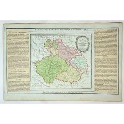
Etats de Boheme Divisee en Toutes Leurs Provinces...
An attractive and informative map of the Bohemian part of Germany by French cartographer, Louis Brion de la Tour. It notes numerous towns, cities, rivers, forests, mounta...
Date: Paris, 1790
Selling price: ????
Please login to see price!
Sold in 2019
Carte des Departemens de Paris, de la Seine et de l'Oise de la Marne.
A striking 1790 map featuring parts of the Ile-de-France, Champagne-Ardenne and Bourgogne regions of France, including Paris, by the French cartographer Louis Brion de la...
Date: Paris, 1790
Selling price: ????
Please login to see price!
Sold in 2018
Carte des Departemens de la Mayenne, de la Sarte, de Maine et Loire, D'indre et Loir...
This is a lovely 1790 map of the Pays de la Loire, Center, Poitou-Charentes, and Bourgogne regions of France by the French cartographer Louis Brion de la Tour. It covers ...
Date: Paris, 1790
Selling price: ????
Please login to see price!
Sold in 2019
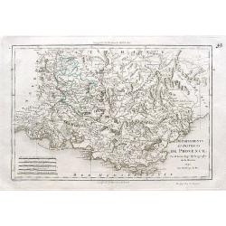
Départements et districts de Provence.
An excellent map of the Provence from Nimes until Monaco,
Date: Paris, ca. 1790
Selling price: ????
Please login to see price!
Sold in 2018
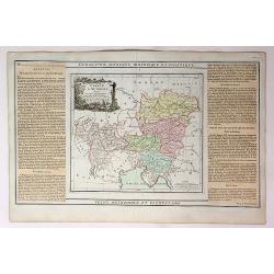
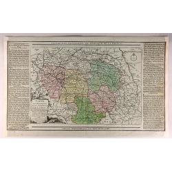
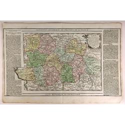
Description Historique et Politique de la France.
A map of the departments of Lot, Aveyron, Lozere, Ardeche, Gers, Garonne, Tarn, Herault, Gard, Htes Pyrenees, Ariège and Aude by Brion, the engineer geographer of the ki...
Date: Paris, 1790
Selling price: ????
Please login to see price!
Sold in 2018
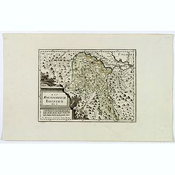
Das Koenigreich Bosnien.
A nice map of Bosnia, mapped with its old borders, prior to the Ottoman rule. Western Bosnia is labelled "Turkish Croatia". The region is seen as very heavily w...
Date: Vienna, 1790
Selling price: ????
Please login to see price!
Sold in 2018
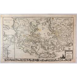
A Correct Map of Ancient Greece.
A striking, highly detailed copper engraved map of Greece in ancient times. The map provides good topographic details. An inset map of north-eastern Sicily, Italy, adorns...
Date: London, 1790
Selling price: ????
Please login to see price!
Sold in 2019
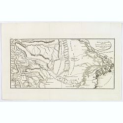
Map of the Steppe between the Lower Volga and the Don, where the Caspian Sea was formerly united with that of Azof.
A Russian map showing the rivers Don and lower Volga flowing into the Caspian Sea. Many other small rivers and tributaries are engraved, along with places and salt lakes ...
Date: London, ca 1790
Selling price: ????
Please login to see price!
Sold in 2020
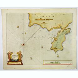
Holy-Head.
An impressive sea chart of Holy-Head in North Wales, from Greenville Collins, Hydrographer to the King (George III), taken from his Great Britain Coasting Pilot atlas. Th...
Date: London, ca 1790
Selling price: ????
Please login to see price!
Sold in 2020
Die Otschakowische Tartarey oder Westliches Nogaj, auch Jedisan. Nro 12.
A map of the Ukraine, between the Bug River and the Dniestr River, and Yeni Duni (todays Odessa) on the Black Sea, Ochakiv also known as Ochakov, Palance and Bender in Mo...
Date: Vienna, 1790
Selling price: ????
Please login to see price!
Sold in 2019
Carte Particuliere des Costes Meridionales d'Angleterre Qui Comprend l'Isle de Wight, et le Havre de Portsmouth. . .
A superb, large sea chart of the Isle of Wight and the Dorsetshire and southern Hampshire coasts between Wareham in Dorset and Bosham in Hampshire.The marine chart includ...
Date: Paris, ca 1790
Selling price: ????
Please login to see price!
Sold in 2019
Des Russischen Reiches Statthalterschaft Archangel Nro. 66.
A map of a part of Russia with Arkhangelsk, the Kola peninsula, and the White Sea. Extends south until Wologda and todays Jaroslawl. With rivers, mountains, lakes, etc.
Date: Vienna, 1790
Selling price: ????
Please login to see price!
Sold in 2019
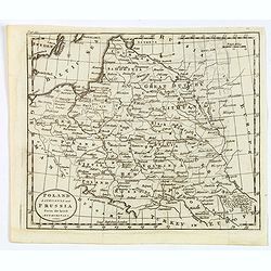
Poland, Lithuania and Prussia from the latest Authorities.
A map of part of Eastern Europe by William Guthrie, published in London in the late eighteenth century. Map shows major towns and cities, rivers, forests, mountains and n...
Date: London, 1790
Selling price: ????
Please login to see price!
Sold in 2020
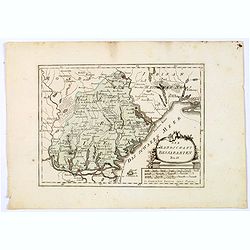
Die Landschaft Bessarabien.
A map of southwestern corner of Ukraine, bordering on the Black Sea, from Izmail on the Danube in the south, to Bender in Transnistria in the north. Larger towns and citi...
Date: Vienna, 1790
Selling price: ????
Please login to see price!
Sold in 2021
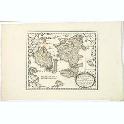
Des Konigreichs Daenemark halbinsel Jutland.
A map of the Danish province of Jutland, from J. Von Reilly's scarce Grosser Deutscher Atlas. Both Von Reilly & Schraembl led a marked revival of map making in Vienna...
Date: Vienna, 1790
Selling price: ????
Please login to see price!
Sold in 2020
Des Konigreichs Daenemark Inseln Seeland, Moen, Bornholm, Funen, Langeland, Laaland, Falster.
A nice map by Von Reilly of several of Denmark's numerous islands. This map shows the islands of: Funen, Zealand, Falster, Langeland, Mon, Lolland, and has an inset of Bo...
Date: Vienna, 1790
Selling price: ????
Please login to see price!
Sold in 2020
Die Landschaft Bukowina Nro. 8.
A fine map of the Bukovina (Bukowina, Bucovina), a region in todays Romania and Ukraine that until WWI was the easternmost province of the Austrian Empire. Shows Chotyn (...
Date: Vienna, 1790
Selling price: ????
Please login to see price!
Sold in 2019
Des Russischen Reiches statthalterschaften Woronesch, Belgorod, Kiow o. Kleinrussland und Charkow od. d. Prussische Ukraine. Nro. 63.
A map of a part of the Ukraine and Russia, with Kiev, Luhansk, Charkow, Belgorod, and Voronezh. Richly detailed with many smaller towns in between. Also the Dniepr, Donez...
Date: Vienna, 1790
Selling price: ????
Please login to see price!
Sold in 2019
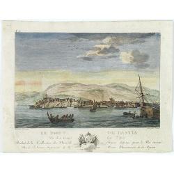
Le port de Bastia vu du coté de l'est. . .
Beautiful engraved profile view of Bastia, after Nicolas Ozanne engraved by Le Gouaz.
Date: Paris, ca. 1790
Selling price: ????
Please login to see price!
Sold in 2023
Galliae Descriptio ex Iulij Caesaris Commentarijs.
An antique map of ancient France or Gaul (Gallia). It is from about 1790 by an unknown mapmaker. There is an interesting cartouche featuring weapons and flags.
Date: Paris, 1790
Selling price: ????
Please login to see price!
Sold in 2021
Die Landschaft Bessarabien.
A map of southwestern corner of Ukraine, bordering on the Black Sea, from Izmail on the Danube in the south, to Bender in Transnistria in the north. Larger towns and citi...
Date: Vienna, 1790
Selling price: ????
Please login to see price!
Sold in 2025
Das Heutige Frankreich.
Franz Johann Joseph von Reilly. He was active as an art dealer, publisher and mapmaker in Vienna. Issued in "Schauplatz der Welt".
Date: Veinna 1791
Selling price: ????
Please login to see price!
Sold
Pass Charta öfver N:ra Delen af Östersjön, Ålands Haf med S:dra Del:en af Botten-Hafvet..
Map of the opposing coasts of Sweden and Finland, centred on the Finnish region of Aland.With inset plans of the Northeasternest islands belonging to Aland in upper right...
Date: Stockholm 1791
Selling price: ????
Please login to see price!
Sold
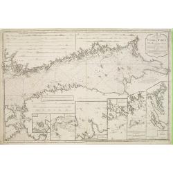
Pass Charta öfver Finska Wiken..
Maritime chart centred on the Gulf of Finland, depicting the opposing coasts of Finland and Russia.With 6 inset plans in the lower part of the map, illustrating enlargeme...
Date: Stockholm 1791
Selling price: ????
Please login to see price!
Sold
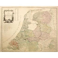
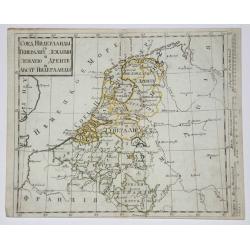
Karte von der Republik der Verenigten Niederlande..
Map of the present-day Netherlands with inset of Limburg. Von Reilly published a large series of maps over a long period of time.
Date: Vienna, 1791
Selling price: ????
Please login to see price!
Sold in 2023
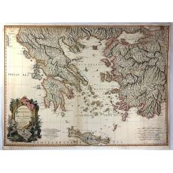
Greece. Archipelago and Part of Anadoli. By L.S. de la Rochette. MDCCXC. London, Published for Willm. Faden, Geographer to the King. January 1st. 1791
Large Folio engraved map of Greece and Western part of Turkey from W. Faden, engraved by William Palmer. Showing the Peloponnese, Central Greece, southern part of Albania...
Date: London, 1791
Selling price: ????
Please login to see price!
Sold in 2009
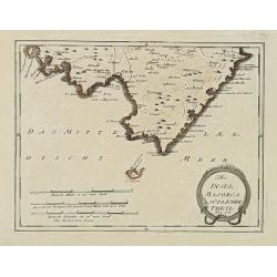
Der Insel Majorca Südlicher Theil. . .
Map showing the southern part of Majorca and just off the south coast of Mallorca, the island of Cabrera. Including cities of Palma, Santueri, Estarella. Published by Fra...
Date: Vienna, 1791
Selling price: ????
Please login to see price!
Sold in 2010
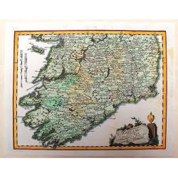
Des Konigreichs Ireland Provint Mounster
This detailed map of southern Ireland depicts the detail of the provinces of Leinster & Connaught. The copper engraved map illustrates the "Map of Munster" ...
Date: Vienna, 1791
Selling price: ????
Please login to see price!
Sold in 2013
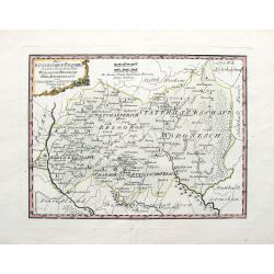
Die Markgraftschaft in ihre Kreise Eingetheilt Nro. 103.
Nice detailed copper engraved map of the Margraviate of Lustia divided into parts. Embellished with a unique diamond-shaped, ribboned cartouche.Joseph von Reilly (1766–...
Date: Vienna, 1791
Selling price: ????
Please login to see price!
Sold in 2016
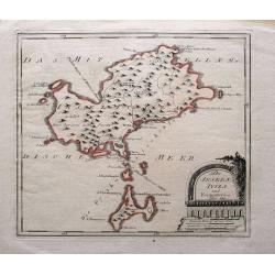
Die Inseln Iviza und Formentera.
Very rare map showing Ibiza and Formentera. With interesting notes in German: Formentera being uninhabited; scattered houses on Ibiza; passage for large ships;...
Date: Vienna, 1791
Selling price: ????
Please login to see price!
Sold in 2015
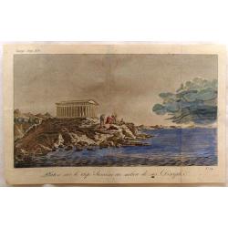
Platon Sur le Cap Sunium au Milieu de ses Disciples.
View of the Temple of Poseidon with Plato and Disciples by Bocage. Prepared in 1791 to illustrate the travels of Anacharis.
Date: Paris, 1791
Selling price: ????
Please login to see price!
Sold in 2019
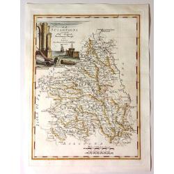
La Scampagna.
Fine map of “La Sciampagna" (Champagne) by Bartolammeo Borghi. Edited by Vincenzo Pazzini Carli and is from the atlas "Atlante Novissimo".Striking cartou...
Date: Sienna, 1791
Selling price: ????
Please login to see price!
Sold in 2021
Greece, Archipelago and Part of Anadoli by L.S. De La Rochette
A large folio engraved map of Greece and part of Turkey. Engraved by William Palmer. Showing the Peloponnese, Central Greece, southern part of Albania, Constantinople in ...
Date: London, 1791
Selling price: ????
Please login to see price!
Sold in 2016
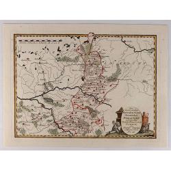
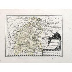
Der Koniglichen Republik Polen Woiwodschaft Podlachien...
Pleasing map of the Royal Republic of Poland by Franz von Reilly in 1791. It features a decorative title cartouche with busts and a wolf. Franz von Reilly (1766 - 1820) ...
Date: Vienna, 1791
Selling price: ????
Please login to see price!
Sold in 2018
La Norvegia divisa Nelle Sue, Provincie Di nuova Projezione.
A fine large map of Norway, engraved by Zuliani after Pitteri. Few maps of Norway on its own were published during this period. Map shows the country divided into its pro...
Date: Venice, 1791
Selling price: ????
Please login to see price!
Sold in 2019
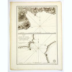
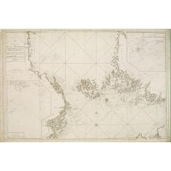
Plan de la Rade d'Angra, en L'Ile Tercere. . . / Plan de la Rade de Fayal. . .
A twin chart of the two harbours of Angra and Fayal (Faial) in the Azores, surveyed by the Depot General de la Marine in Paris towards the end of the eighteenth century. ...
Date: Paris, ca 1791
Selling price: ????
Please login to see price!
Sold in 2019
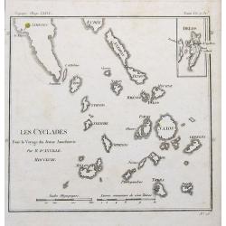
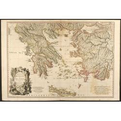
Les Cyclades. . .
A map of Greek islands called the Cyclades in the Aegean Sea. The map extends from Athens to Anafe. Including Andros, Mikonos, Naxos, Ios, Milos, Santorini. An inset map ...
Date: Paris, 1791
Selling price: ????
Please login to see price!
Sold in 2019
Die Englischekuste dem Nordlichen Frankreich.
Von Reilly's map of the English Channel, the Channel Islands, southern England and northern France. From the Atlas Schauplatz der funf Theile der Welt. With some coastal ...
Date: Vienna, 1791
Selling price: ????
Please login to see price!
Sold in 2021