Browse Listings in Europe
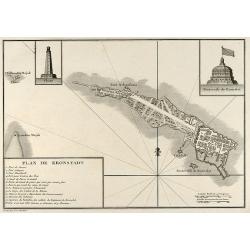
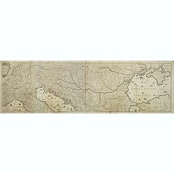
Plan de Kronstadt
Engraved map of Kronstadt / Kronshtadt on the Kotlin Island west of St. Petersburg in Russia. From the Atlas Volume of "Histoire physique, morale, civile et politiqu...
Date: Paris, 1783
Selling price: ????
Please login to see price!
Sold in 2009
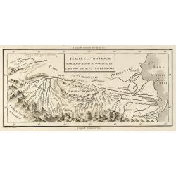
Tereki Fluvii Cursus, Kabarda major minor-que et Caucaso adjacentes Regiones
Engraved map of the Terek River with parts of the Caspian Sea in Russia. From the Atlas Volume of "Histoire physique, morale, civile et politique de la Russie Ancien...
Date: Paris, 1783
Selling price: ????
Please login to see price!
Sold in 2009
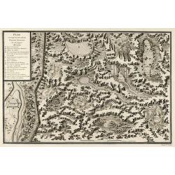
Plan et coupe horisontale du labyrinte souterrain de Koungour Renvoi
Engraved map of the Urals mit the town Kungur in Russia. From the Atlas Volume of "Histoire physique, morale, civile et politique de la Russie Ancienne" by N. G...
Date: Paris, 1783
Selling price: ????
Please login to see price!
Sold in 2009
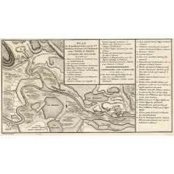
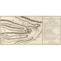
Plan des Expéditions faites par le Gal. Weissman de l\'autre côté du Danube contre Tultschi & Isaktschi. Attaque de Tultschi le 4 Avril 1771
Engraved map of the Danube River between Isaccea, Tulcea in Romania and Izmail in Moldavia. With detail of the expeditions of General Weissman in 1771. From the Atlas Vol...
Date: Paris, 1783
Selling price: ????
Please login to see price!
Sold in 2010
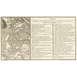
Plan de l\'Attaque du Retranchement, du Camp, et de la Flotte des Turcs par le Gal. Weisman, près de Tultschi, le 30 Juin 1771
Engraved map of the Danube River between Tulcea in Romania and Izmail in Moldavia. With detail of the expeditions of General Weissman in 1771. From the Atlas Volume of &q...
Date: Paris, 1783
Selling price: ????
Please login to see price!
Sold in 2010
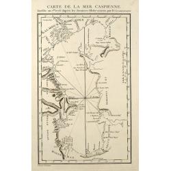
Carte de la Mer Caspienne
Engraved map of the Caspian Sea. From the Atlas Volume of "Histoire physique, morale, civile et politique de la Russie Ancienne" by N. G. Le Clerc. Engraved by ...
Date: Paris, 1783
Selling price: ????
Please login to see price!
Sold in 2009
Plan de la Bataille & de la Victoire remportée par les Russes sur les Turcs commandés par le Grand Visir près de la riviere Kagul en Bessarabie. le 21 Julliet, 1770
Engraved map of the Battle of Cahul in today Moldavia during the Russo-Turkish War 1768-1774 on 21 July 1770. From the rare Atlas Volume of "Histoire physique, moral...
Date: Paris, 1783
Selling price: ????
Please login to see price!
Sold in 2009
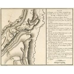
Plan de l'Attaque & de la Victoire remportée par les Russes sur les Turcs et les Tartars près du Large en Moldavie le 7 Julliet, 1770
Engraved map of the Battle of at the Large in today Moldavia during the Russo-Turkish War 1768-1774 on 7 July 1770. From the rare Atlas Volume of "Histoire physique,...
Date: Paris, 1783
Selling price: ????
Please login to see price!
Sold in 2009
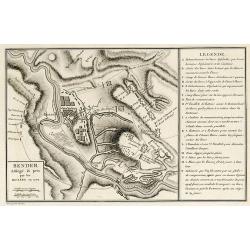
Bender Assiégé & pris par les Russes en 1770
Engraved map of the Battle of Bender in today Moldavia during the Russo-Turkish War 1768-1774 in 1770. From the rare Atlas Volume of "Histoire physique, morale, civi...
Date: Paris, 1783
Selling price: ????
Please login to see price!
Sold in 2009
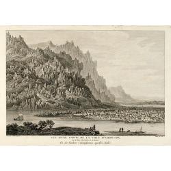
Vue d'une Partie de la Ville d'Iakoutsk Sur le Rive Occidentale de la Léna, et des Rochers Colonniformes appellés Stolbi
Beautiful view of the city Yakutsk at the Lena River in Siberia. From the Atlas Volume of "Histoire physique, morale, civile et politique de la Russie Ancienne&a...
Date: Paris, 1783
Selling price: ????
Please login to see price!
Sold in 2009
Kiakta
Beautiful view of the city Kyakhta at the Kyakhta River in Russia close to the Mongolian border. From the Atlas Volume of "Histoire physique, morale, civile et polit...
Date: Paris, 1783
Selling price: ????
Please login to see price!
Sold in 2009
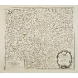
Le cercle de Baviere. . .
Fine map of Bavaria with a decorative title and scale cartouche. Including the towns of Regensburg, Passau, etc.Alexis-Hubert Jaillot (1632-1712), was a French cartograph...
Date: Paris, 1783
Selling price: ????
Please login to see price!
Sold in 2012
Le cours du Danube dédié au roy. . .
A later edition of this beautiful and detailed map of the river Danube, originally published by Du Val in 1703. Here with the date "1783" and the address change...
Date: Paris, 1783
Selling price: ????
Please login to see price!
Sold in 2011
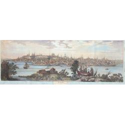
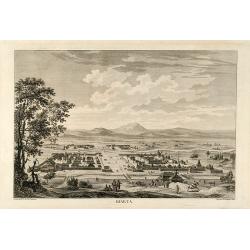
Cazan 1767
A marvellous, spectacular and large panoramic view of Kasan across the river Volga.
Date: Paris, 1783
Selling price: ????
Please login to see price!
Sold in 2013
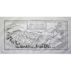
Tereki Fluvii Cursus, Kabarda major minor-que et Caucaso adjacentes Regiones
Detailed map of the Terek River in present day Georgia and Russia, and parts of the Caspian Sea. Names many rivers and places. With impressive representation of the Cauca...
Date: Paris, 1783
Selling price: ????
Please login to see price!
Sold in 2012
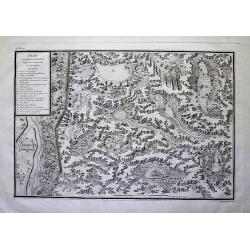
Plan et coupe horisontale du labyrinte souterrain de Koungour Renvoi
Very interesting map of parts of the Ural mountains near Kungur city and the Sylwa River. Shows the "underground labyrinth", with the legend explaining sand hil...
Date: Paris, 1783
Selling price: ????
Please login to see price!
Sold in 2012
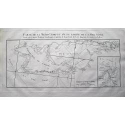
Carte de la Mer d'Azof et d'une Partie de la Mer Noire Levée en 1774 par Monsieur Kinsbergen...
Very detailed map of the Crimea peninsula, the Sea of Azov, and the Black Sea. Shows many place names, and depth soundings. With inset map "Plan du Détroit de Zabac...
Date: Paris, 1783
Selling price: ????
Please login to see price!
Sold in 2012
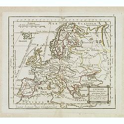
L'Europe Divisée Suivant ses principaux Etats . . .
Scarce map of Europe prepared by de La Fosse and published by L.J. Mondhare for his Atlas Général a l'usage des colleges et maisons d'education.. Louis Joseph Mondhare ...
Date: Paris, 1783
Selling price: ????
Please login to see price!
Sold in 2019
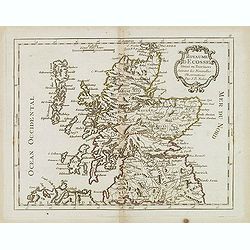
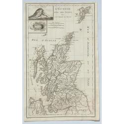
Royaume d'Ecosse. . .
Scarce map of Scotland prepared by Nolin and published by L.J. Mondhare for his Atlas Général a l'usage des colleges et maisons d'education.. Louis Joseph Mondhare was ...
Date: Paris, 1783
Selling price: ????
Please login to see price!
Sold in 2013
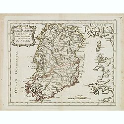
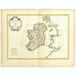
Isle et Royaume d'Irlande. . .
Scarce map of Ireland prepared by Nolin and published by L.J. Mondhare for his Atlas Général a l'usage des colleges et maisons d'education.. Louis Joseph Mondhare was a...
Date: Paris, 1783
Selling price: ????
Please login to see price!
Sold in 2016
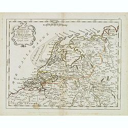
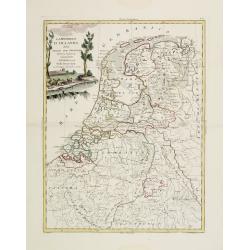
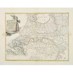
Carte des provinces Unies des Pays Bas connue sous le nom d'Hollande. . .
Scarce map of The Netherlands prepared by Nolin and published by L.J. Mondhare for his Atlas Général a l'usage des colleges et maisons d'education.. Louis Joseph Mondha...
Date: Paris, 1783
Selling price: ????
Please login to see price!
Sold in 2014
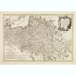
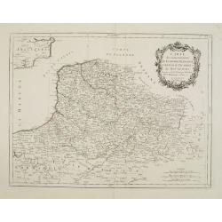
Etats de la couronne de Pologne . . .
Scarce map of Poland prepared by Nolin and published by L.J. Mondhare for his Atlas Général a l'usage des colleges et maisons d'education.. Louis Joseph Mondhare was ac...
Date: Paris, 1783
Selling price: ????
Please login to see price!
Sold in 2013
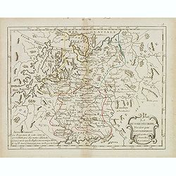
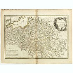
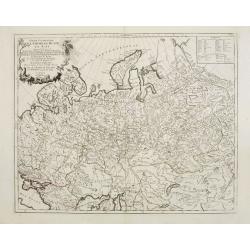
La Russie d' Europe divisée par gouvernemens . . .
Scarce map of Russia prepared by Nolin and published by L.J. Mondhare for his Atlas Général a l'usage des colleges et maisons d'education.. Louis Joseph Mondhare was ac...
Date: Paris, 1783
Selling price: ????
Please login to see price!
Sold in 2014
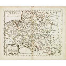
Le Royaume de Hongrie et la Turquie d'Europe. . .
Scarce map of Greece, Romania, Bulgaria and Hungary prepared by Nolin and published by L.J. Mondhare for his Atlas Général a l'usage des colleges et maisons d'education...
Date: Paris, 1783
Selling price: ????
Please login to see price!
Sold in 2017
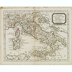
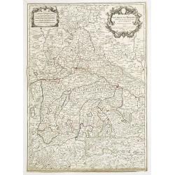
L'Italie divisée en ses différents Etats Royaumes et Republiques. . .
Scarce map of Italy prepared by Nolin and published by L.J. Mondhare for his Atlas Général a l'usage des colleges et maisons d'education.. Louis Joseph Mondhare was act...
Date: Paris, 1783
Selling price: ????
Please login to see price!
Sold in 2023
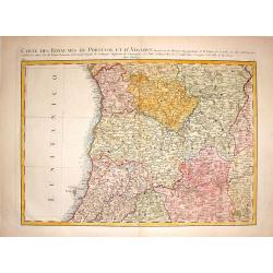
Carte des Royaumes de Portugal et D'Algarue.
Detailed engraved map of the northern part of Portugal including cities, towns, rivers, lakes, forests and mountains. Giovanni Antonio Bartolomeo Rizzi Zannoni (1736 - 1...
Date: Paris, 1783
Selling price: ????
Please login to see price!
Sold in 2015
Carte Generale de la Pologne avec tous les Etats qui en dependent..
Attractive map of Poland, ornated with a rococo title cartouche. Boundaries outlined in hand color.Prepared by Giovanni Antonio Bartolomeo Rizzi Zannoni, one of the leadi...
Date: Paris ca 1783
Selling price: ????
Please login to see price!
Sold in 2014
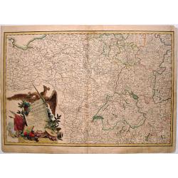
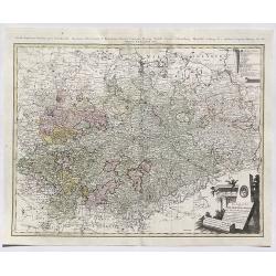
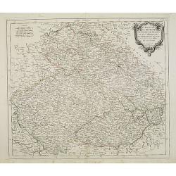
Carte de L'Empire D'Alemagne Avec Les Etats de Boheme Dressee.
Striking map featuring south western Germany, Luxemburg and part of Austria. Lovely cartouche with double headed crowned eagle with sword, musical instruments, canon &am...
Date: Paris, c1783
Selling price: ????
Please login to see price!
Sold in 2019
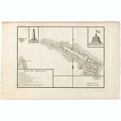
Plan de Kronstadt.
Map of the Island, Harbors and Fortifications of Kronstadt off St. Petersburg. From the Atlas Volume of "Histoire physique, morale, civile et politique de la Russie ...
Date: Paris, 1783
Selling price: ????
Please login to see price!
Sold in 2018
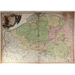
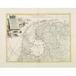
Partie Meridionale Des Pays Bas.
A pleasing example of Jean Janvier's 1783 decorative map of the southern portions of the Pays Bas, or Belgium and Luxembourg. It covers modern day Belgium and Luxembourg,...
Date: Paris, 1783
Selling price: ????
Please login to see price!
Sold in 2018
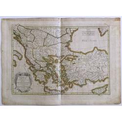
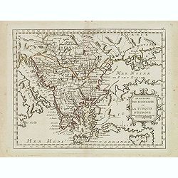
Turquie d' Europe
This finely engraved map is roughly centered on Greece, including the islands of Crete and Cyprus. The map covers the region from Bosnia and Serbia to the Black Sea and C...
Date: Paris, 1783
Selling price: ????
Please login to see price!
Sold in 2016
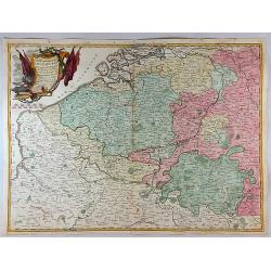
Partie Meridionale des Pays Bas Qui Comprend les Provinces de Brabant, Gueldre, Limbourg, Luxembourg, Hanaut, Namur, Flandre, cambresis et Artoir...
A striking example of Janvier's decorative map of the southern portions of the Pays Bas, or Belgium and Luxembourg. It covers modern day Belgium and Luxembourg, with adja...
Date: Paris, 1783
Selling price: ????
Please login to see price!
Sold in 2017
![[Two maps] L'Italie divisée en ses différents etats, royaumes et républiques . . .](/uploads/cache/42816-250x250.jpg)
[Two maps] L'Italie divisée en ses différents etats, royaumes et républiques . . .
Attractive map of Italy, ornated with a decorative title cartouche. Boundaries outlined in hand color.Prepared by Le Sieur Janvier, Jean Denis [Robert], French geographer...
Date: Paris, ca 1783
Selling price: ????
Please login to see price!
Sold in 2018
![[Two maps] Partie méridionale des Pays-Bas . . .](/uploads/cache/42817-250x250.jpg)
[Two maps] Partie méridionale des Pays-Bas . . .
Attractive map of the Netherlands, ornated with a decorative title cartouche. Boundaries outlined in hand color.Prepared by Le Sieur Janvier, Jean Denis [Robert], French ...
Date: Paris, ca 1783
Selling price: ????
Please login to see price!
Sold in 2019
Carte d'Irlande Projettée et assujettie aux Observations Astronomiques. . .
Attractive map of Ireland, ornated with a decorative title cartouche. Boundaries outlined in hand color.Prepared by Le Sieur Janvier, Jean Denis [Robert], French geograph...
Date: Paris, ca 1783
Selling price: ????
Please login to see price!
Sold in 2019
Carte generale de la Pologne . . .
Attractive map of Poland, ornated with a decorative title cartouche. Boundaries outlined in hand color.Prepared by Le Sieur Janvier, Jean Denis [Robert], French geographe...
Date: Paris, ca 1783
Selling price: ????
Please login to see price!
Sold in 2018
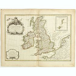
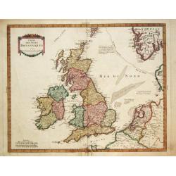
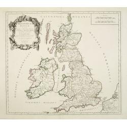
Les Isles Britanniques comprenant les Royaumes d'Angleterre, d'Ecosse et d'Irlande . . .
Attractive map of the British isles, ornated with a decorative title cartouche. Boundaries outlined in hand color.Prepared by Le Sieur Janvier, Jean Denis [Robert], Frenc...
Date: Paris, ca 1783
Selling price: ????
Please login to see price!
Sold in 2019
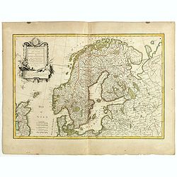
Les Couronnes du Nord comprenant les royaumes du Suede, Danemark et Norwege . . .
Attractive map of Scandinavia, ornated with a decorative title cartouche. Boundaries outlined in hand color.Prepared by Le Sieur Janvier, Jean Denis [Robert], French geog...
Date: Paris, ca 1783
Selling price: ????
Please login to see price!
Sold in 2019
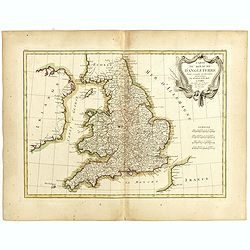
Carte du Royaume d'Angleterre . . .
Attractive map of the United Kingdom, ornated with a decorative title cartouche. Boundaries outlined in hand color.Prepared by Le Sieur Janvier, Jean Denis [Robert], Fren...
Date: Paris, ca 1783
Selling price: ????
Please login to see price!
Sold in 2019
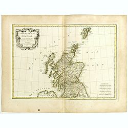
Carte du Royaume d'Ecosse . . .
Attractive map of Scotland, ornated with a decorative title cartouche. Boundaries outlined in hand color.Prepared by Le Sieur Janvier, Jean Denis [Robert], French geograp...
Date: Paris, ca 1783
Selling price: ????
Please login to see price!
Sold in 2019
![[4 maps] Carte du Gouvernement de Bretagne . . . / Carte du Gouvernement de l'Isle de France . . . / Carte des Gouvernements de Flandre Françoise, / Carte du Gouvernement de Normandie...](/uploads/cache/42824-250x250.jpg)
[4 maps] Carte du Gouvernement de Bretagne . . . / Carte du Gouvernement de l'Isle de France . . . / Carte des Gouvernements de Flandre Françoise, / Carte du Gouvernement de Normandie...
Four attractive maps of French provinces, ornated with a decorative title cartouche. Boundaries outlined in hand color.Prepared by Le Sieur Janvier, Jean Denis [Robert], ...
Date: Paris, ca 1783
Selling price: ????
Please login to see price!
Sold in 2020
![No title [Map of part of Germany and Poland].](/uploads/cache/43022-250x250.jpg)
No title [Map of part of Germany and Poland].
Prepared by Giovanni Antonio Bartolomeo Rizzi Zannoni, one of the leading cartographers of the late 18th century, as well as being an astronomer, surveyor and mathematici...
Date: Paris, Lattré, 1783
Selling price: ????
Please login to see price!
Sold in 2019
![[Set of 3 maps] L'Allemagne divisée par cercles . . . / Carte de l'Empire d'Allemagne . . . / No title map.](/uploads/cache/43025-250x250.jpg)
[Set of 3 maps] L'Allemagne divisée par cercles . . . / Carte de l'Empire d'Allemagne . . . / No title map.
[Set of 3 maps] L'Allemagne divisée par cercles . . . / Carte de l'Empire d'Allemagne . . . / No title map.
Date: Paris, Lattré, 1783
Selling price: ????
Please login to see price!
Sold in 2019
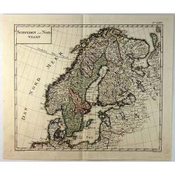
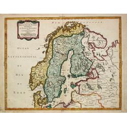
Schweden und Norwegan.
A detailed map of Sweden and Norway by Sotzman in Germany in 1793. Engraved by W. Sander. Daniel Sotzmann (1754-1840) was a German cartographer who was active for the &qu...
Date: Germany, 1783
Selling price: ????
Please login to see price!
Sold in 2019
Carte de la Mer D'Azof et D'Une Partie de la Mer Noire.
Engraved map of the Crimean Peninsula with the Black Sea and the Sea of Azov in Russia. From the Atlas Volume of "Histoire physique, morale, civile et politique de ...
Date: Paris, 1783
Selling price: ????
Please login to see price!
Sold in 2019
L'Ecosse avec ses Isles.
A decorative antique map of Scotland and islands, with two inlays of Craig Phadrich forested hill. It was published by Barbie and engraved by Doudan.Jean-Denis Barbié, k...
Date: Paris, 1783
Selling price: ????
Please login to see price!
Sold in 2023
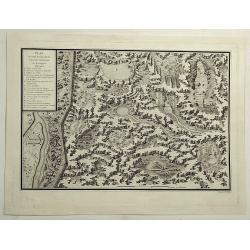
Plan et Coupe Horisontale du Labyrinte Souterrain de Koungour Renvoi.
A striking and highly detailed copper engraved chart showing Kungur and its fortifications. Kungur is a town in the southeast of Perm Krai, Russia, located in the Ural Mo...
Date: Paris, 1783
Selling price: ????
Please login to see price!
Sold in 2021
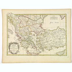
Turquie d'Europe et partie de celle d'Asie divisee. . .
An attractive map centered on the Aegean Sea, encompassing the whole Balkan Peninsula and part of Turkey.It includes also Crete and Cyprus. Decorated with a pretty title ...
Date: Paris, ca 1783
Selling price: ????
Please login to see price!
Sold in 2021
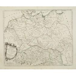
Der Sudliche Theil des Ober-Saechsischen Kreises.
A fine antique map of the southern part of Berlin & Upper-Saxony extending from Hildesheim and Küstrin in the north to Schweinfurth, Leitmeritz and Lauban in the sou...
Date: Nuremberg, 1783
Selling price: ????
Please login to see price!
Sold in 2020
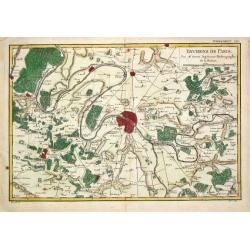
Environs de Paris.
Rigobert Bonne (1727-1795), French cartographer. His maps are found in a.o. Atlas Moderne (1762), Raynal's 'Histoire Philos. du Commerce des Indes' (1774) and 'Atlas Ency...
Date: Paris, 1784
Selling price: ????
Please login to see price!
Sold
Carte du Royaume de Suede Norwege et Partie de Dannemarck.
Pierre Bourgoin, Paris-based engraver and publisher. Published in 1784 his uncommon ' Atlas Élémentaire de la Géographie'.A map depicting Scandinavia.
Date: Paris, 1784
Selling price: ????
Please login to see price!
Sold
La repubblica d'Ollanda divisa nelle sue provincie di nuova projeezione.
Uncommon map of the Netherlands. Embellished with a nice title-cartouche. Engraved by G.V.Pasquali after G.Zuliani.From his Atlante Novissimo, illustrato ed accresciuto s...
Date: Venice 1784
Selling price: ????
Please login to see price!
Sold
La provincie di Frisia, Groninga ed Over-Yssel con parte dell' Ollanda propria..
Uncommon map of the Northern part of the Netherlands. Embellished with a nice title-cartouche. Engraved by G.V.Pasquali after G.Zuliani.From his Atlante Novissimo, illust...
Date: Venice 1784
Selling price: ????
Please login to see price!
Sold
La provincie di Zelanda, Utrecht, Gheldria e Brabante Ollandese con la parte meridionale dell'Ollanda..
Uncommon map of the Southern part of the Netherlands. Embellished with a nice title-cartouche. Engraved by G.V.Pasquali after G.Zuliani.From his Atlante Novissimo, illust...
Date: Venice 1784
Selling price: ????
Please login to see price!
Sold
Carte des Isles Britanniques
Pierre Bourgoin, Paris-based engraver and publisher. Published in 1784 his uncommon ' Atlas Élémentaire de la Géographie'.Decorative map of the British Isles extending...
Date: Paris, 1784
Selling price: ????
Please login to see price!
Sold in 2011
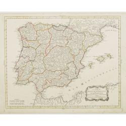
Carte du Royaume d' Espagne et de Portugal.
Detailed map of Spain, Portugal and Baleares islands. Showing also southwestern part of France and north Africa.Published in 1784 in his uncommon "Atlas Élémentair...
Date: Paris, 1784
Selling price: ????
Please login to see price!
Sold in 2008
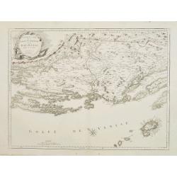
Nouvelle Carte de la Partie Occidentale de Dalmatie, dressee sur les lieux.
Finely and crisply engraved map depicting part of the Dalmatian coastline and its islands between Zadar and Omis, south of Split.In the lower right corner the island Vis,...
Date: Venice, 1776 - 1784
Selling price: ????
Please login to see price!
Sold in 2010
Nouvelle Carte de la Partie Orientale de Dalmatie, dressée sur les lieux.
Finely and crisply engraved map depicting the southern part of the Dalmatian coastline and its islands.Encompassing the area from the southern half of Brac island to the ...
Date: Venice, 1776 - 1784
Selling price: ????
Please login to see price!
Sold
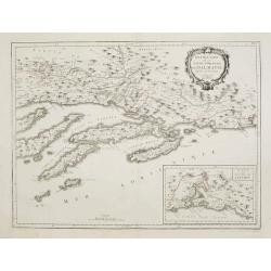
Partie Méridionale du Royaume de Naples où se trouvent la Calabre et l'Isle et Royaume de Sicile.
Finely and crisply engraved map of southern Italy, depicting Sicily and the region Calabria with remarkable topographical detail.Ornated with a large title cartouche and ...
Date: Venice, 1776 - 1784
Selling price: ????
Please login to see price!
Sold in 2015
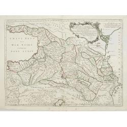
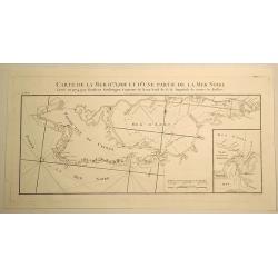
Carte de la Géorgie et des pays situés entre la Mer Noire et la Mer Caspienne..
Finely and crisply engraved map depicting the area comprehended between the Black Sea and the Caspian Sea.With ornamental title cartouche and noteworthy topographical det...
Date: Venice, 1776 - 1784
Selling price: ????
Please login to see price!
Sold
Partie Occidentale de l\'Empire de Russie en Asie..
Finely and crisply engraved map of the north-western part of Russia, with noteworthy topographical detail.Ornamental title cartouche in the upper left corner surrounded w...
Date: Venice, 1776 - 1784
Selling price: ????
Please login to see price!
Sold in 2009
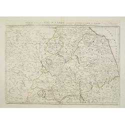
Gouvernements de Flandre Françoise, d'Artois, de Picardie..
Detailed map encompassing northwestern part of France, with the Channel and tip of southern England.Venetian edition of the map by Bellin, to whom Santini gives credit in...
Date: Venice, 1776 - 1784
Selling price: ????
Please login to see price!
Sold in 2008
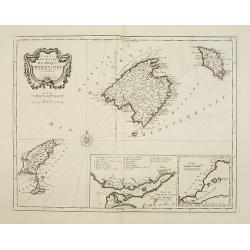
Carte des Isles de Majorque, Minorque, et Yvice..
Decorative map representing the Balearic islands, Minorca, Majorca, Ibiza. With 2 insets and an ornamental title cartouche.Venetian edition of the map by Bellin, to whom ...
Date: Venice, 1776 - 1784
Selling price: ????
Please login to see price!
Sold in 2008
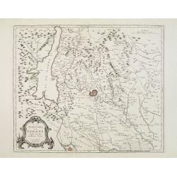
Le Territoire de Verone dressé sur les meilleures Cartes.
Finely and crisply engraved map centered on Verona. Showing lake Garda and Mantua.Large decorative title cartouche in the lower left corner. Relief shown pictorially.
Date: Venice, 1776 - 1784
Selling price: ????
Please login to see price!
Sold in 2018
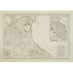
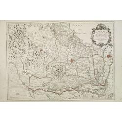
Partie Septentrionale de l'Etat de l'Eglise, contenant les légations de Ferrare, de Bologne, et de Romagne..
Finely and crisply engraved map depicting Romagna and part of Emilia with remarkable topographical detail. Including Remini, Ravenna, Bologna, etc.2 inset maps respective...
Date: Venice, 1776 - 1784
Selling price: ????
Please login to see price!
Sold
Partie de milieu de l'Etat de l'Eglise contenant la légation d'Urbin, la Marche, l'Ombrie..
Finely and crisply engraved map illustrating the regions Umbria and Marche with remarkable topographical detail.Centered on Perugia. Title on top. Relief shown pictoriall...
Date: Venice, 1776 - 1784
Selling price: ????
Please login to see price!
Sold
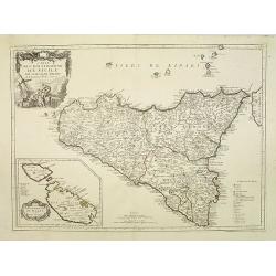
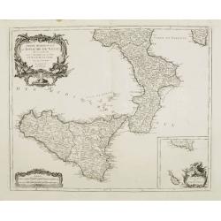
Carte de l\'Isle et Royaume de Sicile. . .
Finely and crisply engraved map of Sicily and the Lipari Islands, with remarkable topographical detail.Venetian edition of de l\'Isle\'s map, from \"Atlas Universel\...
Date: Venice, 1776 - 1784
Selling price: ????
Please login to see price!
Sold in 2009
Germania Antiqua in quatuor magnos populos..
A fine map of ancient Germany, Poland and the Netherlands. Ornamental title cartouche in the lower left corner.Venetian edition of Giles Didier Robert De Vaugondy's map, ...
Date: Venice, 1776 - 1784
Selling price: ????
Please login to see price!
Sold in 2008
Britannicae Insulae in quibus Albion.. Et Ivernia..
Map of the British Isles. Ornated with a rococo title cartouche in the upper left corner.Venetian edition of Giles Didier Robert De Vaugondy's map based on Sanson. From &...
Date: Venice, 1776 - 1784
Selling price: ????
Please login to see price!
Sold in 2008
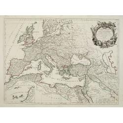
Romani Imperii occidentis .. Tabula Geographica..
Finely and crisply engraved map of the Roman Empire centered on Italy and Greece.Showing the Mediterranean basin together with its hinterland in Africa and Asia. Inset ma...
Date: Venice, 1776 - 1784
Selling price: ????
Please login to see price!
Sold in 2009
Carte du Padouan du dogado, et de la plus grande partie du vicentin. . .
Finely and crisply engraved map of Vicence, Padua and Venice region.Showing to the right the Lagune of Venice.Venetian edition of Giles Didier Robert De Vaugondy's map fr...
Date: Venice, 1776 - 1784
Selling price: ????
Please login to see price!
Sold in 2015
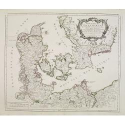
Royaume de Danemarck..Sélande, Laland.
Finely and crisply engraved map of Denmark.Venetian edition of Giles Didier Robert De Vaugondy's map from Atlas Universel printed in 1776-84.Ornamental title cartouche in...
Date: Venice, 1776 - 1784
Selling price: ????
Please login to see price!
Sold in 2016
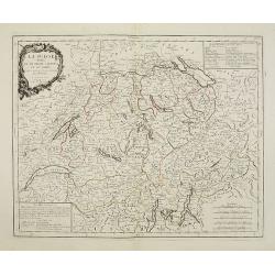
La Suisse divisée en ses treize cantons et ses alliés..
Finely and crisply engraved map of Switzerland from Geneva to Lake Constance.Venetian edition of Giles Didier Robert De Vaugondy\'s map from Atlas Universel printed in 17...
Date: Venice, 1778 - 1784
Selling price: ????
Please login to see price!
Sold in 2009
Le Royaume de Boheme.. Moravie et Lusace.
Finely and crisply engraved map of Czechoslovakia, including Pilsen.Venetian edition of Giles Didier Robert De Vaugondy's map from Atlas Universel printed in 1776-84.Orna...
Date: Venice, 1777 - 1784
Selling price: ????
Please login to see price!
Sold in 2023
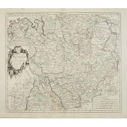
Cercle de Westphalie divisé en tous ses Etats et Souverainetés.
Finely and crisply engraved map of central Germany, including the river Rhine from Deventer till Bonn, with Dusseldorf. In upper left , inset of the area of Emden until O...
Date: Venice, 1776 - 1784
Selling price: ????
Please login to see price!
Sold in 2016
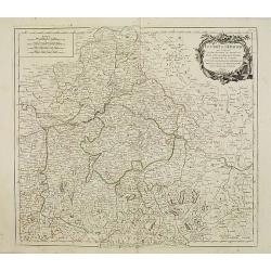
Le cercle De Baviere.. et la prevoté de Berchtolsgaden.
Finely and crisply engraved map centered on Regensburg, including some great skiing resort areas of Austria and part of Germany, centered on Passau, Ingollstat, Salzburg....
Date: Venice, 1776 - 1784
Selling price: ????
Please login to see price!
Sold in 2021
Le Tyrol sous le nom duquel l'on comprend Le comté de Tyrol..
Finely and crisply engraved map of Tyrol .Venetian edition of Giles Didier Robert De Vaugondy's map from Atlas Universel printed in 1776-84.Ornamental title cartouche in ...
Date: Venice, 1778 - 1784
Selling price: ????
Please login to see price!
Sold in 2023
Royaume de Pologne.
Detailed map encompassing present-day Poland .Venetian edition of the map by Bellin, to whom Santini gives credit in the cartouche.From "Atlas Universel" publis...
Date: Venice, 1776 - 1784
Selling price: ????
Please login to see price!
Sold in 2009
Royaume de Hongrie, Principauté de Transilvanie..
Detailed map encompassing present day Hungary and parts of Romania, Czechoslovakia, Bosnia, etc.Venetian edition of the map by Bellin, to whom Santini gives credit in the...
Date: Venice, 1776 - 1784
Selling price: ????
Please login to see price!
Sold in 2008
Royaume d'Esclavonie et du Duché De Syrmie..
Detailed map encompassing show us Danube and to the right Belgrade.Venetian edition of the map by Bellin, to whom Santini gives credit in the cartouche.From "Atlas U...
Date: Venice, 1776 - 1784
Selling price: ????
Please login to see price!
Sold in 2008