Browse Listings in Europe
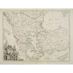
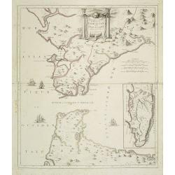
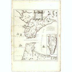
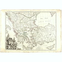
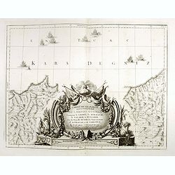
Turquie d'Europe..
Detailed map encompassing present day Greece and part of Turkey. In the lower right corner a large depiction of Cyprus. Venetian edition of the map by Bellin, to whom San...
Date: Venice, 1776 - 1784
Selling price: ????
Please login to see price!
Sold in 2008
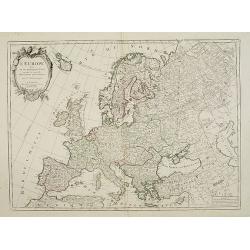
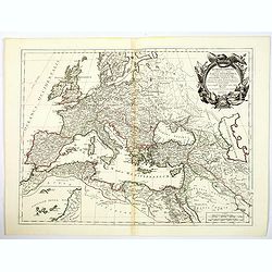
L'Europe divisée en ses principaux Etats..
Attractive map of Europe, ornated with a decorative title cartouche. From "Atlas Universel" published by Santini in 1776-84.Prepared by Le Sieur Janvier, Jean d...
Date: Venice, 1776 - 1784
Selling price: ????
Please login to see price!
Sold in 2008
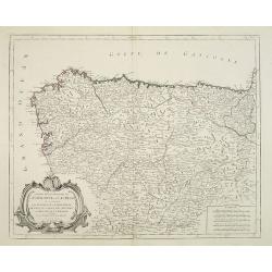
Partie Septentrionale de la Couronne de Castille..
Detailed map of the north-western part of Spain. Also depicting a small part of southern France.Prepared by "Robert de Vaugondy fils," to whom Santini gives cre...
Date: Venice, 1776 - 1784
Selling price: ????
Please login to see price!
Sold in 2011
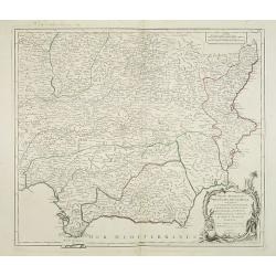
Partie Meridionale des Etats de Castille où se trouvent..
Detailed map of the southern half of Spain. Prepared by "Robert de Vaugondy fils", to whom Santini gives credit in the cartouche.From "Atlas Universel"...
Date: Venice, 1776 - 1784
Selling price: ????
Please login to see price!
Sold in 2013
Nouvelle Carte du Détroit de Gibraltar et de l''Isle de Cadix..
Decorative map centered on the Strait of Gibraltar. With an inset plan of Gibraltar, decorative title cartouche and four vessels.From "Atlas Universel" publishe...
Date: Venice, 1776 - 1784
Selling price: ????
Please login to see price!
Sold in 2008
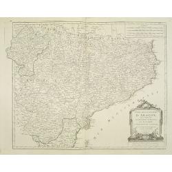
Etats de la Couronne d'Aragon
Detailed map of the eastern part of Spain. Numerous place-names of counties, cities, towns, physical features.Prepared by Robert de Vaugondy fils, to whom Santini gives c...
Date: Venice, 1776 - 1784
Selling price: ????
Please login to see price!
Sold in 2008
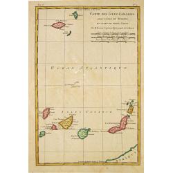
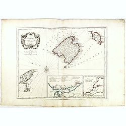
Carte des Isles Canaries, avec l''Isle de Madere et celle de Porto Santo
Rigobert Bonne (1727-1795), French cartographer. His maps are found in a.o. Atlas Moderne (1762), Raynal''s Histoire Philos. du Commerce des Indes (1774) and Atlas Encycl...
Date: Paris, 1784
Selling price: ????
Please login to see price!
Sold in 2010
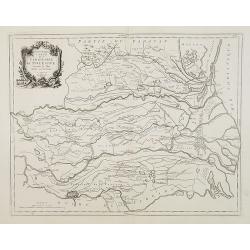
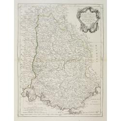
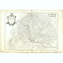
Nouvelle carte du Territoire de Polesine Suivant le Plan dresse sur les lieux.
Finely and crisply engraved map illustrating the area of Polesine, roughly corresponding with the Province of Rovigo.Large decorative title cartouche in the upper left. R...
Date: Venice, 1776 - 1784
Selling price: ????
Please login to see price!
Sold in 2013
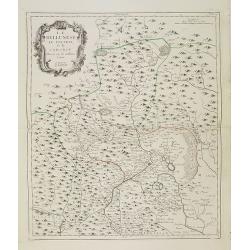
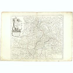
Le Bellunése, le Feltrin, et le Cadorin. Dressés sur les meilleures Cartes.
Finely and crisply engraved map depicting part of Veneto, roughly corresponding to today province of Belluno.Large decorative title cartouche in the upper left corner.Rem...
Date: Venice, 1776 - 1784
Selling price: ????
Please login to see price!
Sold in 2017
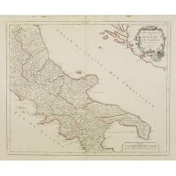
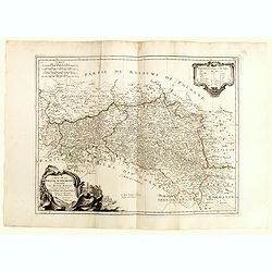
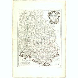
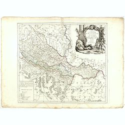
Partie Septentrionale du Royaume de Naples..
Finely and crisply engraved map of southern Italy, except the region Calabria.Ornated with a large title cartouche in the upper right corner.With remarkable topographical...
Date: Venice, 1776 - 1784
Selling price: ????
Please login to see price!
Sold in 2023
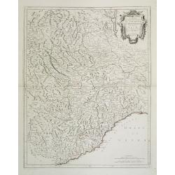
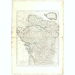
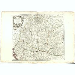
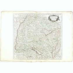
Carte des Gouvernements de Dauphiné et de Province. . .
Attractive map of part of France, covering the eastern part of the Gulf of Lyon with its hinterland. Extending as far as Nice and Grenoble.Decorated with a rococo title c...
Date: Venice, 1777 - 1784
Selling price: ????
Please login to see price!
Sold
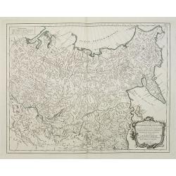
Partie Orientale de l\'Empire de Russie en Asie. . .
Finely and crisply engraved map of the north-eastern part of Russia, including Siberia.Noteworthy topographical detail is shown. Ornamental title cartouche in the lower r...
Date: Venice, 1776 - 1784
Selling price: ????
Please login to see price!
Sold in 2009
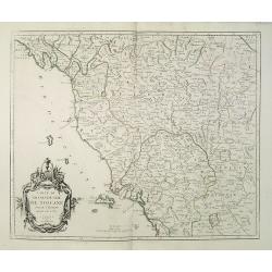
Carte du Grand-Duché de Toscane par le Sr. Robert. . .
Finely and crisply engraved map of Tuscany.Large decorative title cartouche in the lower left corner. Relief shown pictorially. The map was prepared by the Venetian carto...
Date: Venice, 1784
Selling price: ????
Please login to see price!
Sold in 2009
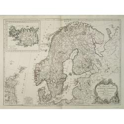
Les Royaumes de Suede et Norwege divisés par Provinces et Gouvernements Dressés et assujettis aux observations Astronomiques. Par le Sr. Janvier Géographe.
Detailed map of Scandinavia covering Sweden, Norway, Denmark, Finland, and Livonia with a section of Poland and Prussia.The coastlines are well-drawn to illustrate the fj...
Date: Venice, 1784
Selling price: ????
Please login to see price!
Sold in 2009
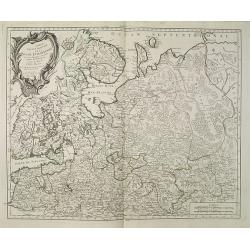
Partie Septentrionale de la Russie Europeenne ou sont distinguees exactement toutes les Provinces, d\'apres le detail de l\'Atlas Russien, Par le Sr. Robert de Vaugondy fils, Geog. ordin? du Roi.
Detailed map of northern European Russia, including Finland. The map was first published by the Venetian cartographer and publisher François (Père) Santini and first pu...
Date: Venice, 1784
Selling price: ????
Please login to see price!
Sold in 2009
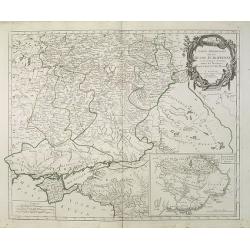
Partie Méridionale de la Russie Europeenne ou sont distinguees exactement toutes les Provinces, d'après le detail de l'Atlas Russien.
Detailed map of southern European Russia, including Yugoslavia. The map was first published by the Venetian cartographer and publisher François (Père) Santini and first...
Date: Venice, 1784
Selling price: ????
Please login to see price!
Sold in 2009
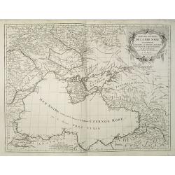
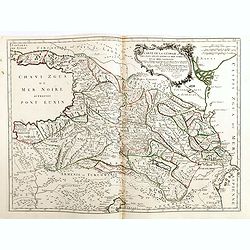
Carte des environs de la Mer Noire. . .
Finely and crisply engraved map centered on Crimea, showing the Black Sea and its hinterland.Noteworthy topographical detail is shown. Decorative title cartouche in the u...
Date: Venice, 1776 - 1784
Selling price: ????
Please login to see price!
Sold in 2009
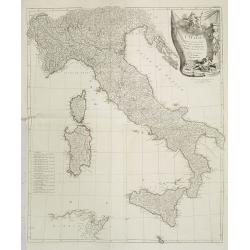
L'Italie publiee sous les auspices de Monseigneur le Duc d'Orleans..
Finely and crisply engraved map of Italy printed on 4 sheets joined, with large decorative title cartouche.Venetian edition of d'Anville's map, from "Atlas Universel...
Date: Venice, 1776 - 1784
Selling price: ????
Please login to see price!
Sold
Carte qui contient la Principauté de Piémont, le Monferrat, et la Comté de Nice, avec la Rivière de Ponent de Gènes.
Finely and crisply engraved map illustrating centered on Turin, including the regions Piedmont, Valle d'Aosta and the western half of Liguria.Showing also Monaco and Nice...
Date: Venice, 1776 - 1784
Selling price: ????
Please login to see price!
Sold in 2016
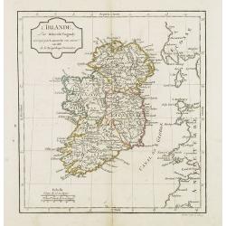
L'Irlande.
A third state with simplified title cartouche and changed text: Corrigée par Lamarche son succes. An IIIe de la République Françaïse. Sponberg does not mention this v...
Date: Paris, 1784
Selling price: ????
Please login to see price!
Sold in 2022
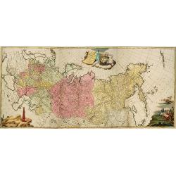
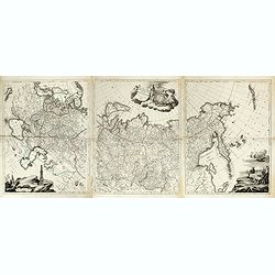
Tabula Geographica Generalis Imperii Russici.
A very large and important map of the whole expanse of the Russian Empire under Catherine the Great stretching from Poland to Kamchatka and the Aleutian Islands, with all...
Date: Augsburg, T.C.Lotter, c.1784
Selling price: ????
Please login to see price!
Sold in 2010
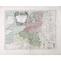
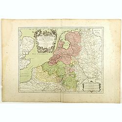
Les Dix-Sept Provinces des Pays-Bas suivant qu'elles sont possedees Par Le Roy la Maison d'Autriche et Les Estats Generaux des Provinces-Unies et Le Roide Prusse
Beautiful map of Belgium and the Netherlands (The Seventeen Provinces of The Netherlands) by the French mapmaker Louis-Charles Desnos. Also includes the regions of Northe...
Date: Paris, 1784
Selling price: ????
Please login to see price!
Sold in 2010
Partie Méridionale de la Russie Europeenne ou sont distinguees exactement toutes les Provinces, d'après le detail de l'Atlas Russien.
Detailed map of southern European Russia, including Yugoslavia. The map was first published by the Venetian cartographer and publisher François (Père) Santini and first...
Date: Venice, 1784
Selling price: ????
Please login to see price!
Sold in 2010
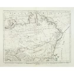
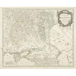
Partie des Gouvernemens d'Astracan et de Woronez: le Kabarda et partie du païs des Cosaques du Don et du Jaik.
Detailed map of the region north of the Black Sea and West of the Caspian Sea. One of the most detailed maps of the region to appear in a commercial atlas.
Date: Venice, 1784
Selling price: ????
Please login to see price!
Sold in 2011
![[Left hand sheet of Tabula Geographica Generalis Imperii Russici. . .]](/uploads/cache/31278-250x250.jpg)
[Left hand sheet of Tabula Geographica Generalis Imperii Russici. . .]
Left hand sheet of the 3 sheet map of the Russian Empire under Catherine the Great. This map was first published in St Petersburg in 1775.Including European part of Russi...
Date: Augsburg, T.C.Lotter, c.1784
Selling price: ????
Please login to see price!
Sold in 2011

Vue D'un Passage du Mont St. Gothard avec Ine Cascade Sur la Russ. A.P.D.R.
Striking hand-colored engraving of the St. Gothard Mountain Pass by Chatelet. It was from Tableau de la Suisse. The engraver was Fessard. Claude-Louis Châtelet was born...
Date: Paris, 1784
Selling price: ????
Please login to see price!
Sold in 2016

Mr. Rapin de Thoyras.
Fine copper engraving of Mr. Rapin de Thoyras (1661-1725) that was the frontpiece for "Harrison's Edition of Rapin's History of England". Adorned by a fancy eng...
Date: London, 1784
Selling price: ????
Please login to see price!
Sold in 2014

John, Duke of Lauderdale.
Fine copper engraving of John, Duke of Lauderdale from "Harrison's Edition of Rapin's History of England". Engraved by John Goldar from a painting by J. Brande...
Date: London, 1784
Selling price: ????
Please login to see price!
Sold in 2015
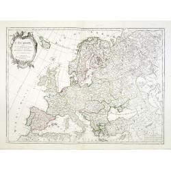
L\'Europe divisée en ses principaux Etats..
Attractive map of Europe, ornated with a decorative title cartouche. From "Atlas Universel" published by Santini in 1776-84.Prepared by Le Sieur Janvier, Jean d...
Date: Venice, 1776 - 1784
Selling price: ????
Please login to see price!
Sold in 2013
Carte de la Géorgie et des pays situés entre la Mer Noire et la Mer Caspienne..
Finely and crisply engraved map depicting the area comprehended between the Black Sea and the Caspian Sea.With ornamental title cartouche and noteworthy topographical det...
Date: Venice, 1776 - 1784
Selling price: ????
Please login to see price!
Sold in 2024
Carte de la Pologne Autrichienne contenant La Russie Rouge et la partie méridionale du Palatinat de Cracovie . . .
Detailed map with Krakow, including the areas of Malopolskie and Podkarpackie and including present-day Ukraine.Santini gives credit to Homann Heirs in the cartouche. Mal...
Date: Venice, 1776 - 1784
Selling price: ????
Please login to see price!
Sold in 2015

English Cathedrals - St. Paul's, St. Mary, St. Clement's.
Lovely hand-colored copper engraving featuring six English cathedrals including St. Pauls's - Covent Gardens, St. Mary - Le Strand, St. Clement's - Strand, St. Mary Wooln...
Date: London, 1784
Selling price: ????
Please login to see price!
Sold in 2015

(Four Fashion Prints of London in 1640).
This fine hand-colored copper engraving is from "THORTON'S NEW & COMPLETE HOSTORY & SURVEY OF LONDON & WESTINSTER", published in London by Alex Hogg...
Date: London, 1784
Selling price: ????
Please login to see price!
Sold in 2016

1st Lord Baltimore, Countess of Suffolk & Countess of Cumberland.
Fine hand-colored copper engraving featuring: George Calvert - The First Lord Baltimore, The Countess of Suffolk and Margaret, Countess of Cumberland.Engraved for "W...
Date: London, 1784
Selling price: ????
Please login to see price!
Sold in 2015
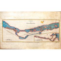
Canal of Trolhaetta.
Copper engraved map by Thomas Kitchen, published by T. Cadell in 1784. The map is of the Trihaetta Canal that is between Gothenburg and Stockholm Sweden.
Date: London, 1784
Selling price: ????
Please login to see price!
Sold in 2016
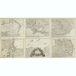
Tabula Geographica Generalis Imperii Russici ad normam novissimarum observatiionum astronomicarum concinnata a Ioh Trescolio et Iac. Schmidio . . . 1782 ( Map in 3 sheets)
Published by Remondini after Johann Treskot and Johann Schmidt map. Their 23-sheet survey of Russia was completed in 1776 for the Imperial Academy of Sciences. Johann Tre...
Date: Venice, 1784
Selling price: ????
Please login to see price!
Sold in 2015
Carte de la partie septentrionale de l'empire Otoman. contenant la Crimée, la Moldavie, la Valakie, la Bulgarie, avec la nouvelle Russie, les gouvernement d'Astracan, et de Voronez, les Tatares cosaques &c. / par le Sr. Rizzi Zannoni.
A detailed six sheet map of the Northern Part of the Ottoman Empire, centered on the Black Sea including parts of Romania, Hungary and Bulgaria. Prepared by Giovanni Anto...
Date: Venice, 1784
Selling price: ????
Please login to see price!
Sold in 2015
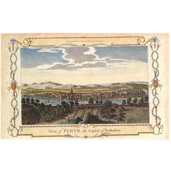
View of Perth, the Capital of Perthshire.
Pleasing hand colored view of Perth, Scotland, from an edition of "THE NEW BRITISH TRAVELLER" published in London by Alexander Hogg in 1784. The engraving was b...
Date: London, 1784
Selling price: ????
Please login to see price!
Sold in 2018
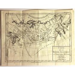
Carte de la Russie Asiatique ou Tartarie Russe
Fine copper engraved engraving featuring the Eastern part of Russia. Engraved by Brion de la Tour, and published in "HISTOIRE UNIVERSELL" by Chez Moutard.
Date: Paris, 1784
Selling price: ????
Please login to see price!
Sold in 2015
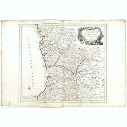
Partie Septentrionale du Royaume de Portugal. . .
Detailed map encompassing the whole northern half of Portugal, with part of the neighboring Spain.Venetian edition of the map by Bellin, to whom Santini gives credit in t...
Date: Venice, 1776 - 1784
Selling price: ????
Please login to see price!
Sold in 2022
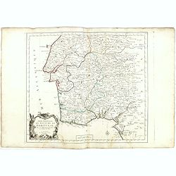
Partie Septentrionale.. Partie Meridionale du Royaume de Portugal..
A detailed map of southern part of Portugal showing the roads, prepared by N.Bellin.Venetian edition of the map by Bellin, to whom Santini gives credit in the cartouche.F...
Date: Venice, 1776 - 1784
Selling price: ????
Please login to see price!
Sold in 2015
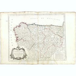
Partie Septentrionale de la Couronne de Castille. . .
Detailed map of the north-western part of Spain. Also depicting a small part of southern France. With ornamental title cartouche and noteworthy topographical detail.The m...
Date: Venice, 1776 - 1784
Selling price: ????
Please login to see price!
Sold in 2018
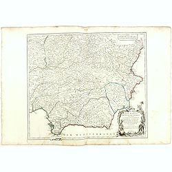
Partie Meridionale des Etats de Castille où se trouvent. . .
A detailed map of the southern half of Spain. Prepared by "Robert de Vaugondy fils," to whom Santini gives credit in the cartouche. From "Atlas Universel&q...
Date: Venice, 1776 - 1784
Selling price: ????
Please login to see price!
Sold in 2018
Nouvelle Carte du Détroit de Gibraltar et de l'Isle de Cadix..
Decorative map centered on the Strait of Gibraltar. With an inset plan of Gibraltar, decorative title cartouche and four vessels.From "Atlas Universel" publishe...
Date: Venice, 1776 - 1784
Selling price: ????
Please login to see price!
Sold in 2015
Carte des Isles de Majorque, Minorque, et Yvice. . .
Decorative map representing the Balearic islands. With 2 insets and an ornamental title cartouche.Venetian edition of the map by Bellin, to whom Santini gives credit in t...
Date: Venice, 1776 - 1784
Selling price: ????
Please login to see price!
Sold in 2015
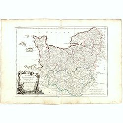
Carte du Gouvernement de Normandie avec celui du Maine et Perche.
Map of Normandy, with ornate title cartouche in lower left bottom. With ornamental title cartouche and noteworthy topographical detail.The map was prepared by the Venetia...
Date: Venice, 1776 - 1784
Selling price: ????
Please login to see price!
Sold
Carte des Gouverneménts d'Anjou et du Saumurois, de la Touraine, du Poitou, du Pays d'Aunis Saintonge - Angoumois. . .
Attractive map of the south western part of France, including isle de Ré and Isle d'Oleron. The map was prepared by R. Bonne, who is given credit in the title cartouche....
Date: Venice, 1777 - 1784
Selling price: ????
Please login to see price!
Sold in 2015
Carte des Gouvernements de Dauphiné et de Province. . .
Attractive map of part of France, covering the eastern part of the Gulf of Lyon with its hinterland. Extending as far as Nice and Grenoble. With ornamental title cartouch...
Date: Venice, 1777 - 1784
Selling price: ????
Please login to see price!
Sold
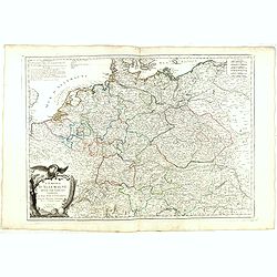
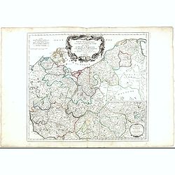
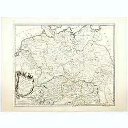
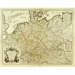
L'Empire d'Allemagne. . .
Detailed map encompassing Germany, the Netherlands, Belgium, Austria, and part of Poland. With ornamental title cartouche and noteworthy topographical detail.The map was ...
Date: Venice, 1776 - 1784
Selling price: ????
Please login to see price!
Sold in 2017
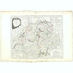
La Suisse divisée en ses treize cantons et ses alliés. . .
Finely and crisply engraved map of Switzerland from Geneva to Lake Constance.With ornamental title cartouche and noteworthy topographical detail.The map was prepared by t...
Date: Venice, 1778 - 1784
Selling price: ????
Please login to see price!
Sold in 2017
Turquie d'Europe..
Detailed map encompassing present day Greece and part of Turkey. In the lower right corner a large depiction of Cyprus. With ornamental title cartouche and noteworthy top...
Date: Venice, 1776 - 1784
Selling price: ????
Please login to see price!
Sold in 2018
Royaume de Hongrie divisee dans ces cercles. . .
Detailed map encompassing present day Hungary with the river Danube and the towns of Belgrade, Budapest, Vienna, etc.From "Atlas Universel" published by Santini...
Date: Venice, 1776 - 1784
Selling price: ????
Please login to see price!
Sold in 2015
Royaume d'Esclavonie et du Duché De Syrmie..
Detailed map encompassing show us Danube and to the right Belgrade.From "Atlas Universel" published by Santini in 1776-84. The atlas is effectively an Italian c...
Date: Venice, 1776 - 1784
Selling price: ????
Please login to see price!
Sold in 2015
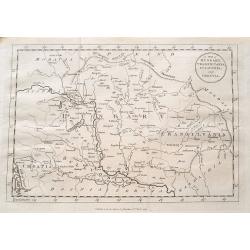
Principauté de Transilvanie et Pays circonvoisins. . .
Detailed map encompassing part of present-day Hungary.With ornamental title cartouche and noteworthy topographical detail.The map was prepared by the Venetian cartographe...
Date: Venice, 1784
Selling price: ????
Please login to see price!
Sold in 2022
Royaume de Hongrie divisee dans ces cercles. . .
Detailed map encompassing present day Hungary with the river Danube and the towns of Belgrade, Budapest, Vienna, etc.Venetian edition of the map by R. de Vaugondy, to who...
Date: Venice, 1776 - 1784
Selling price: ????
Please login to see price!
Sold in 2015
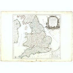
Le royaume d'Angleterre..subdivisé en Shires ou Comtés.
Finely and crisply engraved map of British Isles including the coasts of France and Ireland.Venetian edition of Giles Didier Robert De Vaugondy's map from Atlas Universel...
Date: Venice, 1778 - 1784
Selling price: ????
Please login to see price!
Sold in 2023
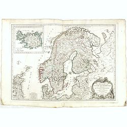
Les Royaumes de Suede et Norwege divisés par Provinces et Gouvernements Dressés et assujettis aux observations Astronomiques. Par le Sr. Janvier Géographe.
Detailed map of Scandinavia and covering Sweden, Norway, Denmark, Finland and Livonia with a section of Poland and Prussia.The coastlines are well-drawn to illustrate the...
Date: Venice, 1784
Selling price: ????
Please login to see price!
Sold in 2017
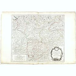
Cercle de Souabe.. les enclaves de la Maison d'Autriche.
Finely and crisply engraved map of western part of Austria.Venetian edition of Giles Didier Robert De Vaugondy's map from Atlas Universel printed in 1776-84.Ornamental ti...
Date: Venice, 1776 - 1784
Selling price: ????
Please login to see price!
Sold in 2016
Le Tyrol sous le nom duquel l'on comprend Le comté de Tyrol. . .
Finely and crisply engraved map of Tyrol centered on Innsbruck .br />With ornamental title cartouche and noteworthy topographical detail.The map was prepared by the Ve...
Date: Venice, 1778 - 1784
Selling price: ????
Please login to see price!
Sold in 2015

Partie septentrionale des Pays-Bas comprenant .. des provinces unies
Finely and crisply engraved map of Netherlands.Venetian edition of Giles Didier Robert De Vaugondy's map from Atlas Universel printed in 1784.Ornamental title cartouche i...
Date: Venice, 1776 - 1784
Selling price: ????
Please login to see price!
Sold in 2015
Partie saptentrionale du cercle de Haute Saxe.. Brandebourg.
Finely and crisply engraved map of north eastern part of Germany, including inset map of Brandenburg.Venetian edition of Giles Didier Robert De Vaugondy's map from Atlas ...
Date: Venice, 1776 - 1784
Selling price: ????
Please login to see price!
Sold in 2015
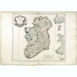
Royaume d'Irelande.. et subdivisé en Comtés.
Finely and crisply engraved map of Ireland. With ornamental title cartouche and noteworthy topographical detail.The map was prepared by the Venetian cartographer and publ...
Date: Venice, 1776 - 1784
Selling price: ????
Please login to see price!
Sold in 2022
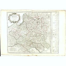
Royaume de Pologne.
Detailed map encompassing present-day Poland. The table provides a breakdown of the sub-regions of the Polish Crown.Venetian edition of the map by R. de Vaugondy, to whom...
Date: Venice, 1776 - 1784
Selling price: ????
Please login to see price!
Sold in 2016
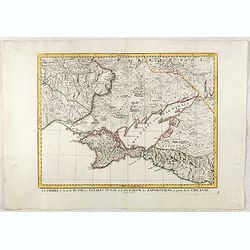
La Crimée, la nouvelle Russie, les Tatares Nugay et d'Oczakow...
Engraved by Perrier, Bourgoin and Arrivet. The map was prepared by the Venetian cartographer and publisher François (Père) Santini and first published in Santini's &quo...
Date: Venice, 1784
Selling price: ????
Please login to see price!
Sold in 2015
Carte de la partie septentrionale de l'empire Otoman. contenant la Crimée, la Moldavie, la Valakie, la Bulgarie, avec la nouvelle Russie, les gouvernement d'Astracan, et de Voronez...
Carte de la partie septentrionale de l'empire Otoman. contenant la Crimée, la Moldavie, la Valakie, la Bulgarie, avec la nouvelle Russie, les gouvernement d'Astracan, et...
Date: Venice, 1784
Selling price: ????
Please login to see price!
Sold in 2018
A map of Hungary, Transilvania, Sclavonia, and Croatia.
Unusual map of Eastern Europe, from Vienna and the Gulf of Venise to the border of Moldova and the Carpathian Mountains. Includes the Balaton lake, Bratislava, Belgrade, ...
Date: London, 1784
Selling price: ????
Please login to see price!
Sold in 2016

Carte Réduite du Golphe de Gascogne. . .
Uncommon chart of the coast of Gascoigne from Brest in Brittany up to Santander in Spain.
Date: Paris, 1756 - 1784
Selling price: ????
Please login to see price!
Sold in 2018
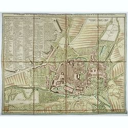
Plan von der fürstlich. sæchsischen Residenz Stadt Weimar. Nürnberg, Homænnischen Erben, 1784.
Very rare town-plan of Weimar, capital of the Duchy of Saxe-Weimar, prepared in 1782 by Franz Ludwig Güssefeld, German engineer and cartographer.In the left part a key (...
Date: Nuremberg, 1784
Selling price: ????
Please login to see price!
Sold in 2018
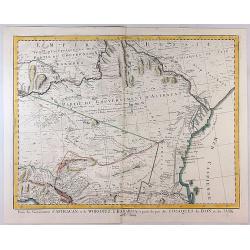
Partie des Gouvernemens d'Astracan et de Woronez le Kabarda et Partei du Pais des Coszques du Don et du Jaik
A detailed pleasing map of Astrakhan Voronezh, the region north of the Black Sea and west of the Caspian Sea. One of the most detailed maps of the region to appear in a c...
Date: Venice, 1784
Selling price: ????
Please login to see price!
Sold in 2023
Les Dix-Sept Provinces des Pays-Bas. . .
Map of the present-day Benelux by L.C. Desnos.
Date: Paris, 1784
Selling price: ????
Please login to see price!
Sold in 2018
![[2 maps] Partie Septentrionale... & Partie Meridionale du Royaume de Portugal...](/uploads/cache/81817-250x250.jpg)
[2 maps] Partie Septentrionale... & Partie Meridionale du Royaume de Portugal...
A pair of large maps of Portugal with bordering Spanish areas. From Fisterra, Vigo and Pontevedra until Cadiz. Extends east until Salamanca and Sevilla. Very detailed, fi...
Date: Venice, 1784
Selling price: ????
Please login to see price!
Sold in 2018
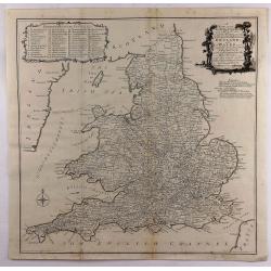
A New most Accurate & Complete Map of All the Direct and the Principal Cross Roads in England and Wales.
A fine double page map of England and Wales delineating all the major roads by Thomas Kitchin for Walpoole's "New and Complete British Traveller". Features incl...
Date: Leipzeg, 1784
Selling price: ????
Please login to see price!
Sold in 2018
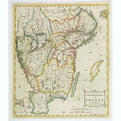
A Map of the Southern Provinces of Sweden.
An attractive map of the southern most provinces of Sweden, published by T. Cadell for Thomas Kitchin, 'Hydrographer to his Majesty' (King George III). Map extends from b...
Date: London, ca 1784
Selling price: ????
Please login to see price!
Sold in 2020
Romani Imperii occidentis . . . Tabula Geographica. . .
Finely and crisply engraved map of the Roman Empire centered on Italy and Greece.Showing the Mediterranean basin together with its hinterland in Africa and Asia. Inset ma...
Date: Venice, 1776 - 1784
Selling price: ????
Please login to see price!
Sold in 2021
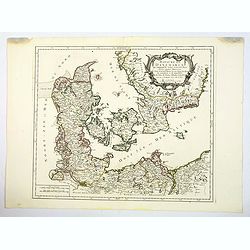
Royaume de Danemarck. qui comprend le Nort-Jutland . . . Sélande, Laland.
A fine and crisp engraved map of Denmark. This is from the Venetian edition of Giles Didier Robert De Vaugondy's map from Atlas Universel printed in 1776-84.With a lovely...
Date: Venice, 1776 - 1784
Selling price: ????
Please login to see price!
Sold in 2020
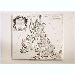
Britannicae Insulae in quibus Albion. . . Et Ivernia. . .
A large map of the British Isles. Ornated with a rococo title cartouche in the upper left corner.Venetian edition of Giles Didier Robert de Vaugondy's map based on Sanson...
Date: Venice, 1776 - 1784
Selling price: ????
Please login to see price!
Sold in 2020
Germania Antiqua in quatuor magnos populos. . .
A fine map of ancient Germany, Poland and the Netherlands. Ornamental title cartouche in the lower left corner.Venetian edition of Giles Didier Robert De Vaugondy's map, ...
Date: Venice, 1776 - 1784
Selling price: ????
Please login to see price!
Sold in 2021
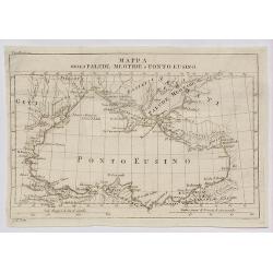
Mappa della Palude Meotide e Ponto Eusino.
A fine map of the Black and Azof Seas in the Crimea.
Date: Venice, 1784
Selling price: ????
Please login to see price!
Sold in 2020
L'Allemagne dressée sur les observations..
Map of Germany, Low Countries, Poland, Switzerland, Northern Italy. Prepared by G.De L'Isle after observations by Kepler and Tycho Brahe.Engraved by Jean Batiste Liébaux...
Date: Paris, 1785
Selling price: ????
Please login to see price!
Sold in 2016
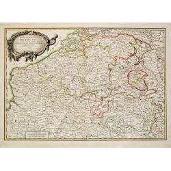
Partie Meridionale des Pays Bas Comprenant les provinces de brabant, Gueldre, Limbourg, Luxembourg, Haynaut, Namur, Flandre, Cambresis et Artois.
A map of Belgium and Luxembourg. Embellished with an attractive title-cartouche.
Date: Paris, 1785
Selling price: ????
Please login to see price!
Sold in 2010