Browse Listings in Europe
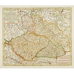
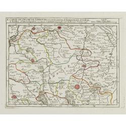
..Bohemen tHertogdom Silesien..Moravien en Lusatien.
Detailed map of Czech Republic. Including the towns of Berlin, Vienna, Regensburg. Isaac Tirion was born in Utrecht ca. 1705. He came to Amsterdam ca. 1725. Tirion publis...
Date: Amsterdam, 1747
Selling price: ????
Please login to see price!
Sold in 2015
![[No title] Gravenhage.](/uploads/cache/21302-250x250.jpg)
[No title] Gravenhage.
A very decorative panoramic view of the town, with detailed keys to the principal buildings and roads of the town.With dedication to Willem Carel Henderik Friso.Engraved ...
Date: The Hague 1747
Selling price: ????
Please login to see price!
Sold
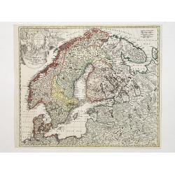
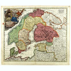
Scandinavia complectens Sueciae, Daniae & Norvegia..
Johann Baptist Homann's well-engraved map has a large decorative cartouche. Detailed map of Scandinavia.Johann Baptist Homann (1663-1724) was a German engraver and publis...
Date: Nuremberg 1747
Selling price: ????
Please login to see price!
Sold
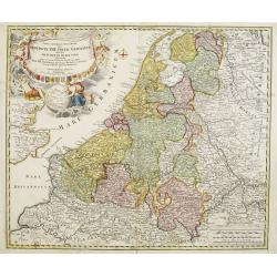
Provinciae XVII Infer Germaniae. . .
A decorative map with colored cartouche surrounded by the coats of arms of Brabant, Limburg, Luxembourg, Geldern, Holland, Zeeland, Zutphen, Flandria, Flanders, Artois, H...
Date: Nurember, 1747
Selling price: ????
Please login to see price!
Sold in 2008
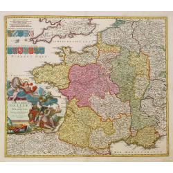
Totius Galliae sive Franciae tabula..
Johann Baptist Homann's well-engraved map of France has a large decorative cartouche and 12 coats of arms of different provinces. Detailed map centred on Venice. Johann B...
Date: Nuremberg, 1747
Selling price: ????
Please login to see price!
Sold
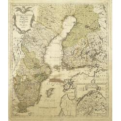
Svea och Göta Riken med Finland och Norland : afritade i Stockholm år 1747
A detailed and rare map of Sweden and Finland, published in Stockholm, 1747. In lower right a cartouche with the north of Norway.Engraved by George Biurman (1700-1755), w...
Date: Stockholm, 1747
Selling price: ????
Please login to see price!
Sold in 2010
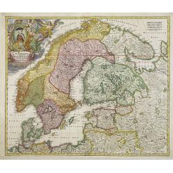
Scandinavia complectens Sueciae, Daniae & Norvegia. . .
Johann Baptist Homann's well-engraved map has a large decorative cartouche. Detailed map of Scandinavia.Johann Baptist Homann (1663-1724) was a German engraver and publis...
Date: Nuremberg, 1747
Selling price: ????
Please login to see price!
Sold in 2011
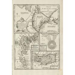
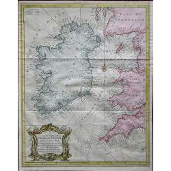
A Map of Old Greenland or Oster Bygd & Wester Bygd ... An Improved Map of Iceland ... A Map of the Islands of Ferro ... A Draught of the Whirlpool on the South East of Sumbo Rocks
An unusual copper engraving by E. Bowen from 'A Complete System of Geography'. Featuring 4 small maps of the North Atlantic Islands Greenland, Iceland and Faroe. A curios...
Date: London, 1747
Selling price: ????
Please login to see price!
Sold in 2011
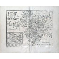
A New and Accurate Map of Savoy, Piemont, and Montferrat Exhibiting the Present Seat of War. . .
An attractive map of the Savoy and Montferrat regions of southeastern France and the northern Italian region of Piedmont on the Mediterranean Sea coast by Emmanuel Bowen...
Date: London, 1747
Selling price: ????
Please login to see price!
Sold in 2010
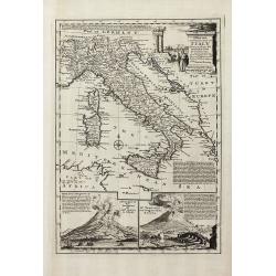
A New & Accurate Map of the Kingdoms of Naples & Sicily
Decorative engraved map of South Italy by Bowen from 'A Complete System of Geography'. Showing the southern part of Italy with Sicily. With one decorative cartouche, a co...
Date: London, 1747
Selling price: ????
Please login to see price!
Sold in 2011
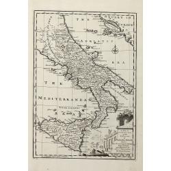
A New and Accurate Map of Italy Drawn from the Latest and Best Authorities, and Regulated by the Most Approved Astronl. Observations
Decorative engraved map of Italy by Bowen from 'A Complete System of Geography'. Below with to inset views of Mount Vesuvius eruptions. With one decorative cartouche, a c...
Date: London, 1747
Selling price: ????
Please login to see price!
Sold in 2013
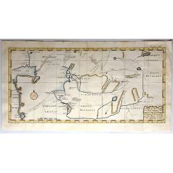
Charta öfwer Södermanland Med Kongl. Maj.ts. Nådigste privilegio utgifven af Kong:e Landtmäteri Contoiret.
A scarce map of the district of Södermanland, including Stockholm in Sweden. A large title cartouche upper right and a key in the upper left corner. The map is a part of...
Date: Stockholm, c.1747
Selling price: ????
Please login to see price!
Sold in 2012
A New & Accurate map of MOSCOVY or Russia in Europe with its Aquisitions. . .
Decorative 1747 copper engraved map of Russia by Emanuel Bowen from "A Complete System of Geography". Showing the region from northern part of Norway to the Bla...
Date: London, 1747
Selling price: ????
Please login to see price!
Sold in 2013
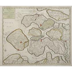
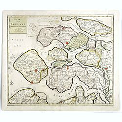
Kaart Van Zeeland.
Interesting map of the Dutch province of Zeeland depicting the individual islands in good detail. The fortified cities are highlighted in red.
Date: Amsterdam, 1747
Selling price: ????
Please login to see price!
Sold in 2013
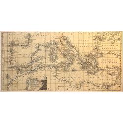
An accurate chart of the Mediterranean and Adriatic Sea. . .
An excellent early engraving of the Mediterranean and Adriatic Sea.
Date: London, 1747
Selling price: ????
Please login to see price!
Sold in 2014
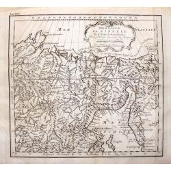
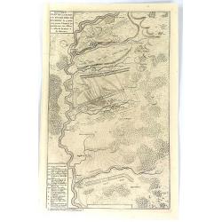
Suite de la Carte de la Siberie et le Paijs de Kamtfchatka.
A detailed map of Russia covering the coast of Siberia and Kamchatka, the island of Sakhalin and part of Tatary. Near the top is the voyage track of Semen Dezhnev who led...
Date: Paris, 1747
Selling price: ????
Please login to see price!
Sold in 2015
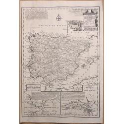
A New & Accurate Map of Spain & Portugal Drawn from the latest Surveys & most approved Maps & Charts The whole being adjusted by Astron Observations. By Emanuel Bowen
A fine Emanuel Bowen map of Spain and Portugal with two inset plans – ‘The Harbour of Port Mahon’ and ‘A Chart of the Straits of Gibraltar, with the Coast of Spai...
Date: London, 1747
Selling price: ????
Please login to see price!
Sold in 2017
Nouveau Plan de la Bataille Donnee Pres de Hochstet ....
The Battle of Blenheim (referred to in some countries as the Second Battle of Höchstädt), fought on 13 August 1704, was a major battle of the War of the Spanish Success...
Date: Amsterdam, 1747
Selling price: ????
Please login to see price!
Sold in 2019
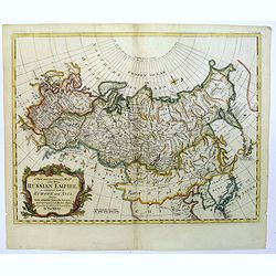
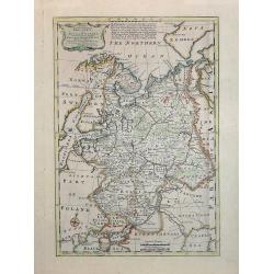
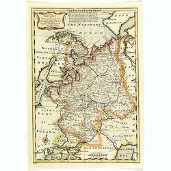
A New and Accurate map of the Whole Russian Empire, as contained both in Europe and Asia...
A pleasant map, by the English cartographer Thomas Kitchin, of the vast Russian Empire, as it was during the middle of the eighteenth century.The map has been colored to ...
Date: London, 1747
Selling price: ????
Please login to see price!
Sold in 2017
![A Chart of the South part of Cephalonia, with the Islands of Zante and the Coast of Morea ... [on sheet with] A Chart of the South Coast of Morea from Venetica to CS. Angelo](/uploads/cache/97451-250x250.jpg)
A Chart of the South part of Cephalonia, with the Islands of Zante and the Coast of Morea ... [on sheet with] A Chart of the South Coast of Morea from Venetica to CS. Angelo
This two part sea chart features the island of Zante and Cephanolia on the left side, and Serigo to Candia (Crete) on the right. Engraved by 'J[oel] Gas[coyne]' this plat...
Date: 1747
Selling price: ????
Please login to see price!
Sold in 2016
A Chart of the Islands Corfu, Pachsu and Antipachsu with ye Channel and Roads between the Island of Corfu & ye Graetian Coast
A superb rare sea chart with rhumb lines of Corfu and nearby coastlines. The main town and castle in Corfu is clearly outlined. It is engraved by 'J[oel] Gascoyne' and wa...
Date: 1747
Selling price: ????
Please login to see price!
Sold in 2016
A New & Accurate Map of Moscovy, or Russia in Europe, with its Acquisitions.
A quaint detailed map of European Russia by Emmanuel Bowen.
Date: London, 1747
Selling price: ????
Please login to see price!
Sold in 2016
Kaart van Zeeland.
Map of the province of Zeeland, with the fortified cities are highlighted in red. Isaac Tirion was born in Utrecht ca. 1705. He came to Amsterdam ca. 1725. Tirion publish...
Date: Amsterdam, 1747
Selling price: ????
Please login to see price!
Sold in 2016
Anhang zu dem Karten von dem Orenburger.
Copper engraved map of Siberia, Russia, from the Caspian Sea to Tashkent, in Uzbekistan. The map depicts the Aral–Caspian Depression, a lowland depression straddling Eu...
Date: Germany, 1747
Selling price: ????
Please login to see price!
Sold in 2018
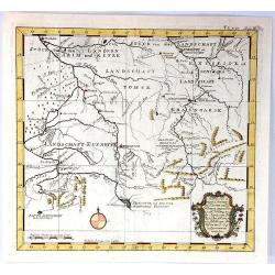
Kurtz von Ernigen Provinzen in Siberien und den Groenzen Yegen China
An unusual antique map of central Siberia featuring Tomsk, Krasnoarsk and Kuznets Oblests (provinces). The bottom of the map borders on China. It features a fancy floral ...
Date: Germany, 1747
Selling price: ????
Please login to see price!
Sold in 2017
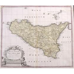
Regni & Insulae Siciliae Tabula geographica ex Archetypo...
A fine and detailed map of Sicily and the Aeolian Islands. Includes many towns, roads, mountains, rivers, bays, etc. Decorated with a large cartouche.
Date: Nuremberg, 1747
Selling price: ????
Please login to see price!
Sold in 2017
Scandinavia complectens Sueciae, Daniae & Norvegia. . .
Johann Baptist Homann's well-engraved map has a large decorative cartouche. Detailed map of Scandinavia.Johann Baptist Homann (1663-1724) was a German engraver and publis...
Date: Nuremberg, 1747
Selling price: ????
Please login to see price!
Sold in 2018
A New & Accurate Map of Moscovy, or Russia in Europe, with its Acquisitions.
A detailed map of European Russia by Emmanuel Bowen. It depicts the European portion of Russia extending from the Gulf of Finland to the Ural Mountains. The map offers ex...
Date: London, 1747
Selling price: ????
Please login to see price!
Sold in 2018
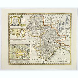
A New and Accurate Map of Savoy, Piedmont, and Montferrat. . .
This is the striking 1747 map of Savoy, Piedmont and Montserrat in northern Italy by Emanuel Bowen. It covers part of modern day France and Italy from Lake Geneva south a...
Date: London, 1747
Selling price: ????
Please login to see price!
Sold in 2018
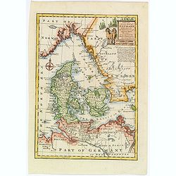
A New and Accurate map of Denmark.
This is the beautiful 1747 map of Denmark by the British cartographer Emanuel Bowen. It covers all of Jutland and the islands of Zealand, Funen and Lolland. Parts of sout...
Date: London, 1747
Selling price: ????
Please login to see price!
Sold in 2020
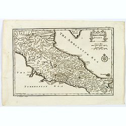
Middle or Proper Italy.
A map of central Italy, from Roman times, and published in "An Universal History from the Earliest Account of Time to the Present". With a quaint title cartouch...
Date: London, ca 1747
Selling price: ????
Please login to see price!
Sold in 2019
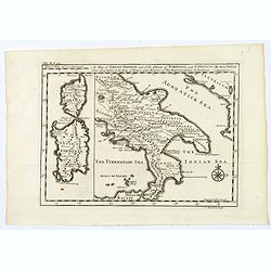
A Map of Great Greece and of the Islands of Sardinia and Corsica. . .
A map showing the islands of Sardinia and Corsica, and southern Italy to the northern tip of Sicily in roman times. From "An Universal History, from the Earliest Acc...
Date: London, 1747
Selling price: ????
Please login to see price!
Sold in 2020
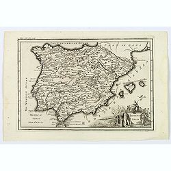
Antient Spain.
A nice map of Ancient Spain, published in "An Universal History from the Earliest Account of Time to the Present". It shows Spain in Roman times, with Latin spe...
Date: London, 1747
Selling price: ????
Please login to see price!
Sold in 2019
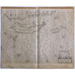
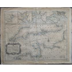
A Correct Chart of St. Georges Channel and the Irish Sea, Including all the Coast of Ireland, and ye West Coast of Great Britain from Cantire to Portland Isle: From the latest & best Observations.
A 1747 nautical chart or maritime map of Ireland and the St. Georges Channel. Engraved by R. W. Seale, the map covers the whole of Ireland as well as adjacent parts of Sc...
Date: London, 1747
Selling price: ????
Please login to see price!
Sold in 2019
A correct Chart of the English Channel - From the No. Foreland to the Lands End on the Coast of England, and from Calais to Brest on the Coast of France . . .
The English Channel, featuring insets of the Isles of Scilly, Falmouth Haven, Plymouth Sound and the Isle of Wight and ye adjacent Harbours. Alderney, Guernsey, Jersey an...
Date: London, 1747
Selling price: ????
Please login to see price!
Sold in 2020
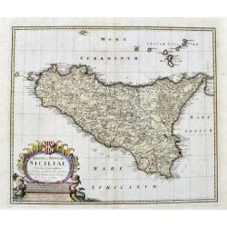
Regni & Insulae Siciliae tabula geographica...
A very detailed map of Sicily and surrounding smaller islands (Lipari, Stromboli, Ustica, etc.). Shows the Etna volcano, rivers, hills, roads, and many place names. With ...
Date: Nuremberg, ca. 1747
Selling price: ????
Please login to see price!
Sold in 2021
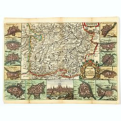
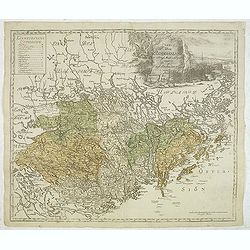
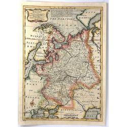
Duche de Baviere. Het Hertogdom Byeren.
A decorative and very detailed map of Bavaria in southern Germany, first drawn by Daniel de la Feuille in 1706 that includes Munich and Augsburg. Surrounded by thirteen m...
Date: Paris, 1747
Selling price: ????
Please login to see price!
Sold in 2021
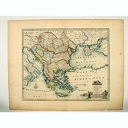
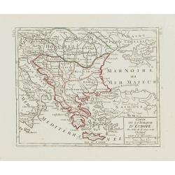
A new & accurate map of Turkey in Europe with the adjacent countries. . .
An excellent mid 18th century map of Greece, including Albania, Macedonia, Romania, Bulgaria, Serbia, Croatia, Hungary etc. the Black Sea and part of Turkey. An early imp...
Date: London, 1747
Selling price: ????
Please login to see price!
Sold in 2023
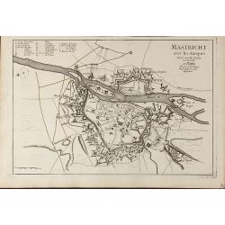
Mastricht avec les Attaques Leve sur les Lieux en Juin 1748. A Paris chez Le Sr. Le Rouge
A rare separate published plan of Maastricht by G. L. le Rouge. Showing the fortified city with important buildings named. With a key from a to x, a mileage scale and a c...
Date: Paris, 1748
Selling price: ????
Please login to see price!
Sold in 2011
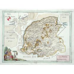
La Frise.
Map of the Dutch province Friesland, decorated with a nice title cartouche and a compass rose in the sea.
Date: Paris 1748
Selling price: ????
Please login to see price!
Sold
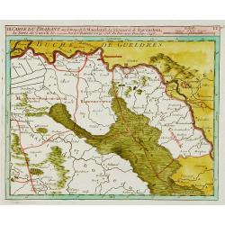
Carte du Brabant ou.. le Maesland.. de Ravenstein..
Covering north-eastern part of present day Noord-Brabant including towns of Grave, Gennep, Vlierlingsbeek, Venray, Bakel, Boxmeer, Heeswijk Dinther.
Date: Paris 1748
Selling price: ????
Please login to see price!
Sold
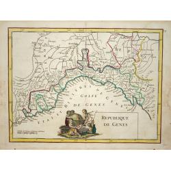
Republique de Genes.
Nice map of northwest Italy and the Gulf of Genoa, at left Nice and Monaco, there is a nice putti-scene in the sea.
Date: Paris 1748
Selling price: ????
Please login to see price!
Sold
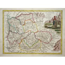
La savoye.
Nice map of the Savoie at the top the lake of Geneva and the Alps.
Date: Paris 1748
Selling price: ????
Please login to see price!
Sold
Carte de la principauté de Liege et de ses environs..
Map of present-day Dutch and Belgium Brabant and Liege, with an imposing title cartouche Carte de la pricipauté de Liége et de ses environs tirée des observations fait...
Date: Liege, ca.1748
Selling price: ????
Please login to see price!
Sold
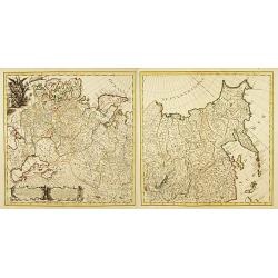
![[2 maps] Novissimum Silesiae Theatrum id est Exactissimus Superioris et Inferioris Silesiae.. (2 maps)](/uploads/cache/21439-250x250.jpg)
[2 maps] Novissimum Silesiae Theatrum id est Exactissimus Superioris et Inferioris Silesiae.. (2 maps)
Impressive, highly detailed map of Silesia adorned with 2 large superb cartouches on 2 opposite corners of the map. The title cartouche is decorated with little angels an...
Date: Amsterdam, c. 1748
Selling price: ????
Please login to see price!
Sold in 2008
Carte Generale de l'Empire de Russie. (2 maps)
Highly decorative copper-engraved map representing the Russian empire. With superb title cartouche and two explanatory cartouches with text translated in Latin and French...
Date: Amsterdam c. 1748
Selling price: ????
Please login to see price!
Sold
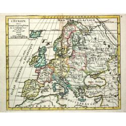
L' Europe.
Gilles Robert de Vaugondy (!686-1766) and son Didier (1723-86), Paris geographers and publishers. Gilles succeedded Pierre Moulart Sanson in 1730. ' Atlas Portatif', 1748...
Date: Paris, 1748
Selling price: ????
Please login to see price!
Sold
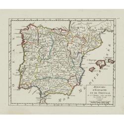
Royaumes d'Espagne et de Portugal.
Detailed map of Spain, Portugal and Baleares islands. Showing also south part of France and Gibraltar. Dated 1748.From Atlas Portatif Universel, by Robert de Vaugondy.Pag...
Date: Paris, ca. 1748
Selling price: ????
Please login to see price!
Sold in 2023
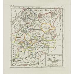
Russie Blanche ou Moscovie. . .
Nice small map of European Russia, framed by "Suede", "Pologne", "Ukraie" ou "Cosaquie", "...
Date: Paris, later than 1748
Selling price: ????
Please login to see price!
Sold in 2009
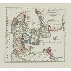
Royaume de Danemark.
Detailed map of Denmark, centered on Själland. Showing also the southernmost tip of the Scandinavian peninsula, Scania. Dated 1748.From Atlas Portatif Universel, by Robe...
Date: Paris, 1748
Selling price: ????
Please login to see price!
Sold
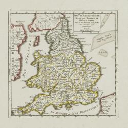
Roy.me d'Angleterre..
Nice small map of England, dated 1748. From Atlas Portatif Universel, by Robert de Vaugondy.Page 5 outside border top left.
Date: Paris, 1748
Selling price: ????
Please login to see price!
Sold
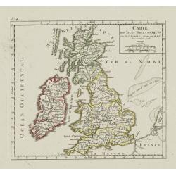
Carte des Isles Britanniques.
Nice small map of the British Isles, dated 1748. From Atlas Portatif Universel, by Robert de Vaugondy.Page 4 outside border top left.
Date: Paris, ca. 1748
Selling price: ????
Please login to see price!
Sold
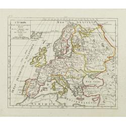
L'Europe. Divisée suivant ses principaux Etats.
Nice small map of Europe, dated 1748. From Atlas Portatif Universel, by Robert de Vaugondy.Page 3 outside border top left.
Date: Paris, ca.1748
Selling price: ????
Please login to see price!
Sold
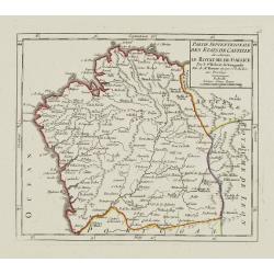
Partie Septentrionale des Etats de Castille où se trouve le Royaume de Gallice..
Detailed map of Galicia, in the northwestern tip of the Iberian Peninsula. From Atlas Portatif Universel, by Robert de Vaugondy.Page 43 outside border top left. Mary Spon...
Date: Paris, later than 1748
Selling price: ????
Please login to see price!
Sold
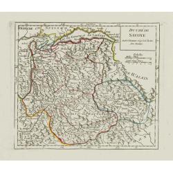
Duché de Savoye.
Detailed small map centered on Savoy, extending eastwards to include the Italian region Valle d'Aosta.From Atlas Portatif Universel, by Robert de Vaugondy. Page 53 outsid...
Date: Paris, later than 1748
Selling price: ????
Please login to see price!
Sold in 2019
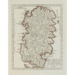
Isle et Royaume de Sardaigne.
Detailed small map of Sardinia. From Atlas Portatif Universel, by Robert de Vaugondy.Page 54 outside border top right. Mary Sponberg Pedley does not mention a state witho...
Date: Paris, later than 1748
Selling price: ????
Please login to see price!
Sold
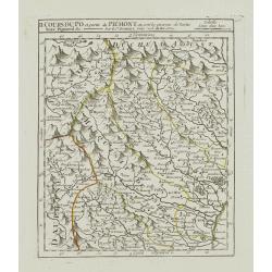
II. Cours du Po et Partie du Piémont où sont les environs de Turin..
Detailed small map showing the northwestern part of Piedmont and a short stretch of the river Po going through Turin.Relief shown pictorially. From Atlas Portatif Univers...
Date: Paris, later than 1748
Selling price: ????
Please login to see price!
Sold
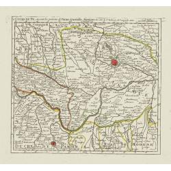
V. Cours du Po, où sont les environs de Parme, Guastalle, Mantoue, &c.
Detailed small map centered on the stretch of the river Po flowing through the region Lombardy, between Villanova sull'Arda and San Siro, southeast of Mantua.From Atlas P...
Date: Paris, later than 1748
Selling price: ????
Please login to see price!
Sold
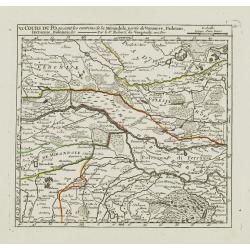
VI. Cours du Po, ou sont les environs de la Mirandole, partie du Veronese, Padouan, Ferrarese, Bolonois, &c.
Detailed small map centered on the stretch of the river Po flowing between Ostiglia and Ro, in the Province of Ferrara.From Atlas Portatif Universel, by Robert de Vaugond...
Date: Paris, later than 1748
Selling price: ????
Please login to see price!
Sold
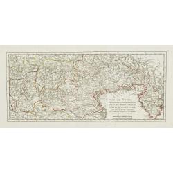
Carte de la Turquie d\'Europe des Isles de la Grece et de l\'Archipel.
Small detailed map encompassing the area between the Adriatic Sea and the Black Sea. Centered on Greece.From Atlas Portatif Universel, by Robert de Vaugondy. Page 63 and ...
Date: Paris, later than 1748
Selling price: ????
Please login to see price!
Sold in 2008
Etat de la Seigneurie et République de Venise avec l'Evêché de Trente.
Detailed small map of northern Italy. Including Istria in the East and extending westwards as far as Bergamo and Crema.From Atlas Portatif Universel, by Robert de Vaugond...
Date: Paris, 1748
Selling price: ????
Please login to see price!
Sold in 2010
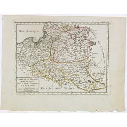
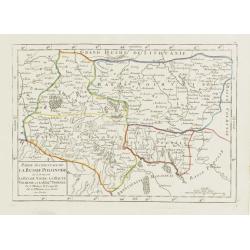
Carte de la Pologne. Aujourd'hui Partagée entre la Russie, l'Empereur et le Roi de Prusse.
Small detailed map showing Poland, Lithuania, the Kaliningrad Oblast, Belarus and part of Ukraine.From Atlas Portatif Universel, by Robert de Vaugondy. Page 35 and Tom. P...
Date: Paris, later than 1748
Selling price: ????
Please login to see price!
Sold in 2020
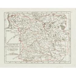
Grand Duché de Lithuanie divisé par Palatinats.
Small detailed map centered on Lithuania and Belarus. From Atlas Portatif Universel, by Robert de Vaugondy.Unrecorded state with erased date. Page 38 outside border top r...
Date: Paris, later than 1748
Selling price: ????
Please login to see price!
Sold
Partie Occidentale de la Russie Polonoise.. Haute Podolie.
Small detailed map showing the western part of Ukraine. From Atlas Portatif Universel, by Robert de Vaugondy.Unrecorded state with erased date. Page 40 outside border top...
Date: Paris, later than 1748
Selling price: ????
Please login to see price!
Sold in 2008
Partie orientale de la Russie Polonaise, où se trouvent la Basse Volhynie et la Basse Podolie.
Small detailed map showing the eastern part of Ukraine, with Volhynia and Podillia. Centered on the course of the Dnieper river.From Atlas Portatif Universel, by Robert d...
Date: Paris, later than 1748
Selling price: ????
Please login to see price!
Sold in 2021
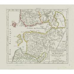
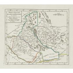
Curlande, Livonie, Ingrie et partie méridionale de Finlande.
Small detailed map showing Latvia, Estonia, part of Russia and southern Finland. With St. Petersburg in the right part.From Atlas Portatif Universel, by Robert de Vaugond...
Date: Paris, later than 1748
Selling price: ????
Please login to see price!
Sold in 2008
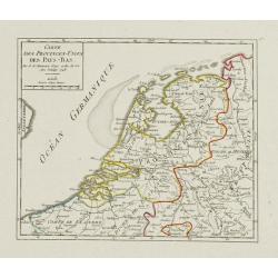
Carte des Provinces-Unies des Pays-Bas.
Attractive small map of the Low Countries. Dated 1748. From Atlas Portatif Universel, by Robert de Vaugondy.Page 17 outside border top right.
Date: Paris, 1748
Selling price: ????
Please login to see price!
Sold
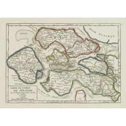
Carte du Comté de Zélande.
Attractive small map illustrating the northern part of Zeeland. From Atlas Portatif Universel, by Robert de Vaugondy.Page 18 outside border top right. Mary Sponberg Pedle...
Date: Paris, later than 1748
Selling price: ????
Please login to see price!
Sold
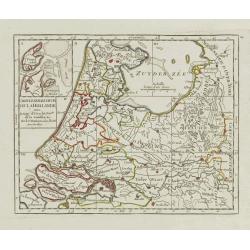
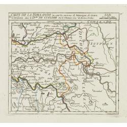
Carte Generale des Six de la Hollande, avec, la Seig? D'Utrecht, Partie de la Gueldre, &c.
Attractive small map illustrating part of the Netherlands, namely the provinces of Noord- and Zuid-Holland, Gelderland and Utrecht.With an inset map of the island of Texe...
Date: Paris, later than 1748
Selling price: ????
Please login to see price!
Sold in 2021
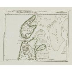
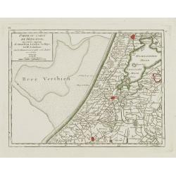
I. Carte du Comté de Hollande où se trouve l'Isle de Texel.
Attractive small map illustrating the northernmost tip of Noord-Holland and Texel. From Atlas Portatif Universel, by Robert de Vaugondy.Unrecorded state with erased date....
Date: Paris, later than 1748
Selling price: ????
Please login to see price!
Sold
II. Partie du Comté de Hollande.. Edam &c.
Attractive small map illustrating the central part of Noord-Holland, between West Friesland and the IJ bay.From Atlas Portatif Universel, by Robert de Vaugondy. Unrecorde...
Date: Paris, later than 1748
Selling price: ????
Please login to see price!
Sold in 2020
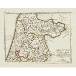
IV. Partie du Comté de Hollande.. Haarlem, Leyden, la Haye..
Attractive small map centered on Zuid Holland, including Leiden, Delft extending northwards as far as Haarlem.From Atlas Portatif Universel, by Robert de Vaugondy. Unreco...
Date: Paris, later than 1748
Selling price: ????
Please login to see price!
Sold in 2017
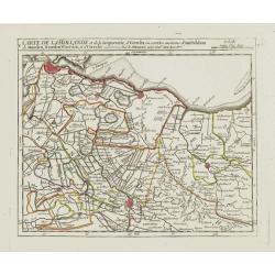
V. Carte de la Hollande et de la Seigneurie, d'Utrecht?
Detailed small map showing an area straddling the provinces of North Holland and Utrecht. Showing Amsterdam in the upper left corner.From Atlas Portatif Universel, by Rob...
Date: Paris, later than 1748
Selling price: ????
Please login to see price!
Sold
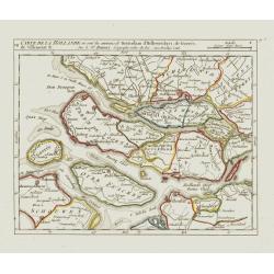
VII. Carte de la Hollande ou sont les environs de Rotterdam..
Attractive small map centered on the island of Voorne-Putten with Rotterdam and Dort[recht]. From Atlas Portatif Universel, by Robert de Vaugondy.Unrecorded state with er...
Date: Paris, later than 1748
Selling price: ????
Please login to see price!
Sold
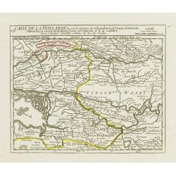
VIII. Carte de la Hollande ou sont les environs de Schoonhove..
Nice small map showing an area straddling the provinces of North Holland, Gelderland and North Brabant, crossed by the rivers Lower Rhine and Meuse.From Atlas Portatif Un...
Date: Paris, later than 1748
Selling price: ????
Please login to see price!
Sold
IX. Carte de la Hollande ou sont les environs de Nimegue..
Attractive small map showing an area straddling the border between the Netherlands and Germany. Centered on Nijmegen.From Atlas Portatif Universel, by Robert de Vaugondy....
Date: Paris, later than 1748
Selling price: ????
Please login to see price!
Sold
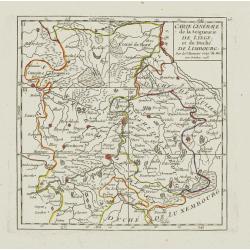
Carte Générale de la Seigneurie de Lyege, et du Duché de Limbourg.
Attractive small map showing an area straddling the border between the Netherlands, Belgium and Germany.Centered on Maastricht. Dated 1748. Divided into 6 sections. From ...
Date: Paris, 1748
Selling price: ????
Please login to see price!
Sold
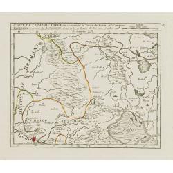
I. Carte de l'Etat de Lyege ou se trouvent la Terre de Leon, et la Campine Lyegeoise.
Attractive small map encompassing the eastern part of the Flemish Limburg. It shows the town of Diest in the lower left corner. Dated 1748.From Atlas Portatif Universel, ...
Date: Paris, 1748
Selling price: ????
Please login to see price!
Sold in 2022
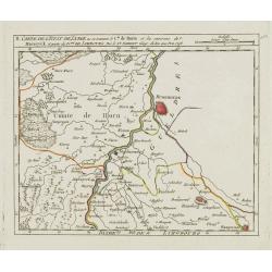
II. Carte de l'Etat de Lyege.. et partie du D.ché de Limbourg.
Attractive small map showing an area straddling the border between the Netherlands, Belgium and Germany. Centered on Roermond. Dated 1748.From Atlas Portatif Universel, b...
Date: Paris, 1748
Selling price: ????
Please login to see price!
Sold
IV. Carte du Duché de Limbourg.. Aix la Chapelle &c.
Attractive small map showing an area straddling the border between the Netherlands, Belgium and Germany.Delimited by the towns of Sittard, Aachen and Dalhem. Dated 1748.F...
Date: Paris, 1748
Selling price: ????
Please login to see price!
Sold in 2012