Browse Listings in Europe
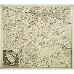
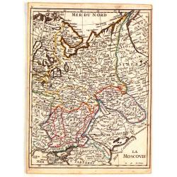
Moscoviae gubernium cum Adiacentibus regionibus. . .
Detailed map of center of Russia. Showing the cities Moscow, Twer, Jaroslaw. This map was included in the important Atlas Russicus, the first atlas of Russia to be publis...
Date: St Petersburg, 1745
Selling price: ????
Please login to see price!
Sold in 2011
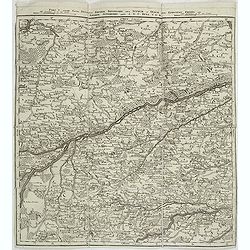
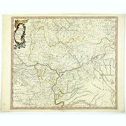
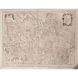
Pars V. ostendit partem Ducatus Bavariae inferioris. . .
Map of southern part of Germany, showing the river Isar from Freising until Landshut. Very detailed map. Prepared by Wilhelm C. Buna and published by Broenner in Frankfur...
Date: Frankfurt, M. Broenner, 1745
Selling price: ????
Please login to see price!
Sold in 2015
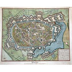
MONS the Capital City of Hainault in ye Low Countries, taken by ye French in 1691...
Superb bird's-eye plan of the city and fortifications of Mons. Beautifully illustrating the city with its buildings and churches in great detail. Also with two windmills,...
Date: London, ca. 1745
Selling price: ????
Please login to see price!
Sold in 2011
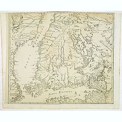
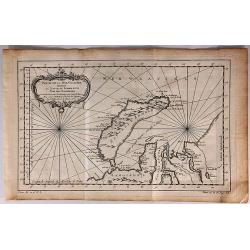
(Finland)
One of the earliest detailed maps of Finland, prepared by Joseph Nicolas De L’Isle and included in a later edition of the "Atlas Russicus". The Russian Academ...
Date: Petersburg, 1745
Selling price: ????
Please login to see price!
Sold in 2012
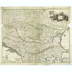
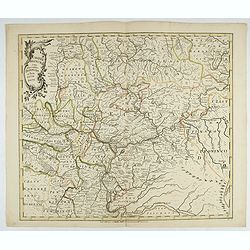
Théatre de la Guerre en Hongarie, Transilvanie &c
Large, four sheet detailed map of Hungary.
Date: Amsterdam c. 1745
Selling price: ????
Please login to see price!
Sold in 2012
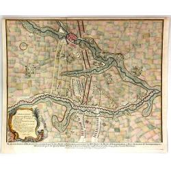
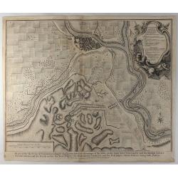
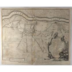
Plan of the Incampment of the Allies at Prats Del Rey.
This large plan of the Encampment at Prat del Rey, Spain, a town approximately 50 Kilometres inland from Barcelona, not far from the modern town of Igualada, in the provi...
Date: London, 1745
Selling price: ????
Please login to see price!
Sold in 2013
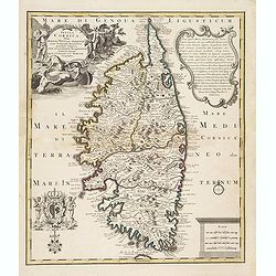
Insula Corsica, Olim Rehni Titulo Insignis . . . .
Large detailed map of Corsica. Splendid cartouche of picturesque scene of people at work engaged in their daily activities admits dogs and local fauna on the upper left c...
Date: Amsterdam, ca 1745
Selling price: ????
Please login to see price!
Sold
Pars VII. Describit partem regim : Monach / Intra Lycum et Isaram. . .
Map of the south of Germany with Munich in the upper right corner and Walchen See in the bottom. The River Lech to the left.
Date: Frankfurt, 1745
Selling price: ????
Please login to see price!
Sold in 2014
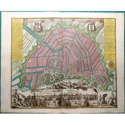
Kaart van Noord-Holland...
Interesting map of the northern part of the Netherlands. Oriented to the west. It extends from Amsterdam northward as far as Texel and southward as far as Enkhuizen. With...
Date: Amsterdam, c1745
Selling price: ????
Please login to see price!
Sold in 2014
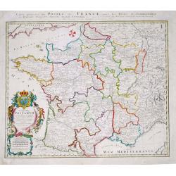
Gallia Postarum geografice designata.
Homann Heirs (of Johann Baptist and Johann Christof) published: Grosser Atlas, 1731, 1737. Geogr. Maior, 1759, Atlas Homannianus, 1762.Alexis Jaillot's map showing the po...
Date: Nurnberg, 1745
Selling price: ????
Please login to see price!
Sold in 2019
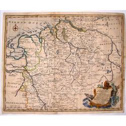
A Correct Map of the North West Part of Germany.
A map of the north western portion of Germany. The cartographer was Emmanuel Bowen and the map is from Mr. Tindal's "Continuation of Rapin's History".Features a...
Date: London, 1745
Selling price: ????
Please login to see price!
Sold in 2016
De Groote Nederlandse Stedenwyzer, vertoonende met een opslag des Oogs, de Afgelegentheden tussen 108 Steden, van de XVII. Nederlandse Provintien. . .
In upper right corner inset map of the Low Countries. The page is filled with a scale which shows distances between cities and provinces.
Date: Amsterdam, 1745
Selling price: ????
Please login to see price!
Sold in 2017
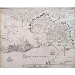
Plan of the City of Barcelona.
Boldly engraved plan of Barcelona. Shows the detailed walled city, surrounded with roads and fields. Numerous fortifications are located, and there is a lettered key (A-X...
Date: London, ca. 1745
Selling price: ????
Please login to see price!
Sold in 2019
Ypres a Strong City and Castle in Flanders, Restored to the Emperor by the Treaty of Utrecht.
A fine and detailed view of the city of Ypres in Flanders as was included in Mr. Tindal's 'Continuation of Mr. Rapin's History of England'.
Date: London, 1745
Selling price: ????
Please login to see price!
Sold in 2016
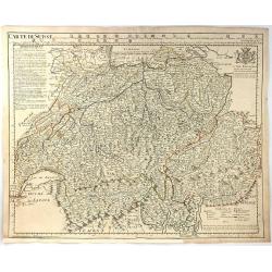
Carte de Suisse.
A large, clear and detailed map of Switzerland and northern Italy, outlining the cantons, with their coats of arms at upper border alongside title. ‘Avertissement’ at...
Date: Paris, 1745
Selling price: ????
Please login to see price!
Sold in 2016
Plan of the Lines of Brabant Forced July 18, 1704 by the Army of the Allies
A detailed military map, engraved from 'Mr. Tindal's Continuation of Mr. Rapin's 'History of Engand'. With maps by Richard William Seale and John Basire, published by Rap...
Date: London, ca. 1745
Selling price: ????
Please login to see price!
Sold in 2019
Amsterdam, die weltberuhmte Haupt - und Handel Statt in Holland (..)
A copper engraved map with original hand coloring. Overall size 55 x 68 cm. A beautifully engraved map of Amsterdam, with 2 coat-of-arms, 2 vignettes in the lower corner,...
Date: Augsburg, ca. 1745
Selling price: ????
Please login to see price!
Sold in 2017
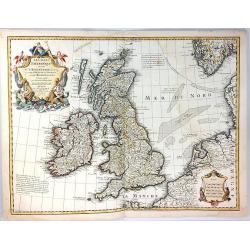
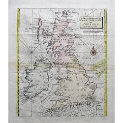
Les Isles Britanniques
A fine example of De L'Isle's map of the British Isles. It was redone by Philippe Buache and published in 1745.Includes a splendid, large, ornate decorative title cartouc...
Date: Paris, 1745
Selling price: ????
Please login to see price!
Sold in 2017
![Die Wahlstadt beij Güntersdorff woselbst des Königs in Preussen Mafestaet den 4ten Junij 1745. . . [Battle of Hohenfriedberg]](/uploads/cache/39375-250x250.jpg)
Die Wahlstadt beij Güntersdorff woselbst des Königs in Preussen Mafestaet den 4ten Junij 1745. . . [Battle of Hohenfriedberg]
A scarce separately issued plan of the Battle of Hohenfriedberg, one of Frederick the Great’s most estimable victories, engraved by the Polish master Bartlomiej Stracho...
Date: Breslau (Wroclaw), Johann Jacob Korn, 1745
Selling price: ????
Please login to see price!
Sold in 2018
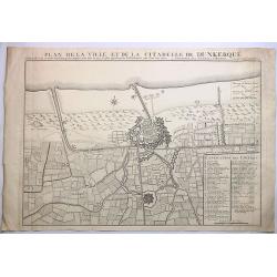
Plan de la Ville et de la Citadelle de Dunkerque.
A striking large example of Covens & Mortier's plan of Dunkerque. The map focuses on the town fortifications and also includes details of the town plan, upper and low...
Date: Amsterdam, 1745
Selling price: ????
Please login to see price!
Sold in 2023
Plan de Charleroy Ville Forte des Pays-Bas dans le Comte de Namur.
A striking example of Covens & Mortier's plan of Charleroy. The map focuses on the town fortifications and includes details of the town plan and environs.The primary ...
Date: Amsterdam, 1745
Selling price: ????
Please login to see price!
Sold in 2019
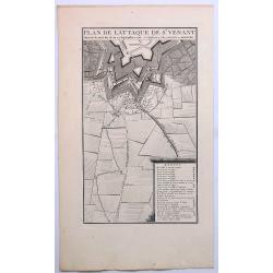
Plan de L'Attaque de St. Venant.
A striking example of Covens & Mortier's plan of St. Venant. The map focuses on the town fortifications and includes details of the town plan and environs. The primar...
Date: Amsterdam, ca. 1745
Selling price: ????
Please login to see price!
Sold in 2019
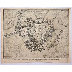
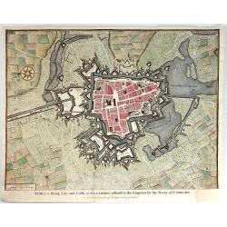
Ypres, a Strong City and Castle in Flanders.
A detailed plan of the City of Ypres, including fortifications, town plan, roads, farms, rivers, and a decorative compass rose. From Tindal's “Continuation of Rapin's H...
Date: London, 1745
Selling price: ????
Please login to see price!
Sold in 2018
Plan of the city & Castle of Chester, Survey'd and Drawn by Alexander de Lavaux.
A rare and important plan of the city of Chester was engraved by Parr but surveyed and drawn by a Dutch engineer, Alexandre De Lavaux. Two large and imposing cartouches c...
Date: London, 1745
Selling price: ????
Please login to see price!
Sold in 2017
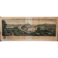
The Southwest Prospect of the City of Durham.
A delightful copperplate engraving of the city of Durham, published in 1745 in London by Samuel and Nathaniel Buck. It shows the ancient city perched high on a hill, over...
Date: London, 1745
Selling price: ????
Please login to see price!
Sold in 2017
A Chart of the Sea Coast of Great Britain and Ireland.
A scarce and attractive sea chart of the British Islands. With many place names along the coats. With a compass rose and rhumb lines.
Date: London, ca. 1745
Selling price: ????
Please login to see price!
Sold in 2017
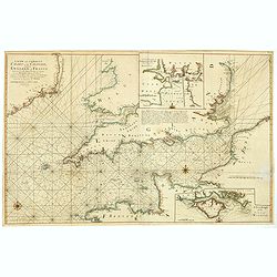
A new and correct chart of the channel between England & France..
The chart includes the South Coast of England from North of the Bristol Channel and of the Thames Estuary, there are insets for Plymouth Sound and the Isle of Wight.
Date: London, 1745
Selling price: ????
Please login to see price!
Sold in 2018
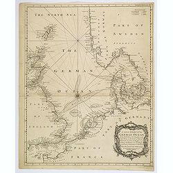
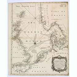
A correct Chart of the German Ocean from the North of Scotland to the Start Point. . .
A large sea chart of the eastern half of the English Channel, the eastern coasts of England and Scotland, the French coast from Normandy and the Channel Islands, up throu...
Date: London, 1745
Selling price: ????
Please login to see price!
Sold in 2020
Plan of the Battle of Saragossa.
An original large 18th century copper engraved antique map of the battle of Saragossa or Zaragoza, Aragon, Spain. Fought on Aug 9th 1710 between the troops of the Allies ...
Date: London, 1745
Selling price: ????
Please login to see price!
Sold in 2019
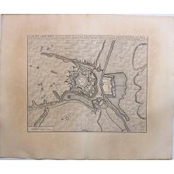
Plan of the Town and Castle of Lerida.
A striking plan of the siege of Lerida by the Bourbon forces under the Duke of Orleans, showing the siege of the town, fortifications, etc. A numbered and lettered key di...
Date: London, 1745
Selling price: ????
Please login to see price!
Sold in 2019
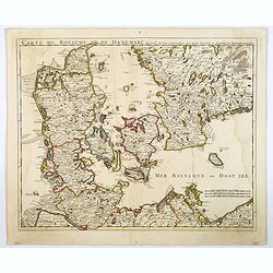
Carte Du Royaume De Danemarc.
A beautifully engraved, highly decorative map showing all of Denmark and southern Sweden, extending north to Warberg, with excellent map detail throughout. Major cities a...
Date: Amsterdam, ca 1745
Selling price: ????
Please login to see price!
Sold in 2020
![[Book with map] Description of Greenland... with map: Old Greenland as to its Eastern and Western Parts vulgo Oster Bygd & Wester Bygd](/uploads/cache/82906-250x250.jpg)
[Book with map] Description of Greenland... with map: Old Greenland as to its Eastern and Western Parts vulgo Oster Bygd & Wester Bygd
Fantastic and rare account by the priest Hans Egede. The scarce folding map (273x354mm shows the southern portions of Greenland, parts of Iceland and James Island. This i...
Date: London, 1745
Selling price: ????
Please login to see price!
Sold in 2020
Casaniae Regnum cum Adiacentibus Provinciis et Parte Fluvii Volgae.
From the first regional atlas of Russia, published by the Academy of Sciences in St. Petersburg, expanding on the cartographic work done previously by Ivan K. Kirilov. Ou...
Date: St. Petersburg, 1745
Selling price: ????
Please login to see price!
Sold in 2020
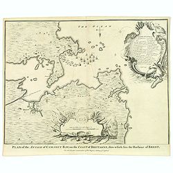
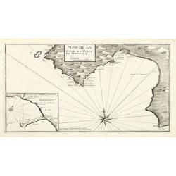
Plan of Attack of Camaret Bay, on the Coast of Bretagne. . .
An interesting and attractive map of Camaret bay in Brittany. The piece depicts a battle scene between British and French naval forces in the vicinity of Brest.It feature...
Date: London, ca 1745
Selling price: ????
Please login to see price!
Sold in 2020
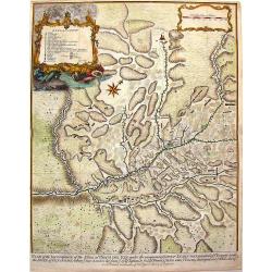
Partie Septentrionale du Duche de Bourgogne ...
Large, detailed map of northern Burgundy, covering the region from Bar-sur-Seine in the North to Dijon and Auxonne in the South East. Embellished with 2 cartouches both d...
Date: Amsterdam, 1745
Selling price: ????
Please login to see price!
Sold in 2022
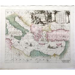
Orientalior Districtus Maris Mediterranei / t'Ooster Gedeelte van de Middelandse Zee.
A sea chart of the Eastern Mediterranean, from Sardinia and Corsica to Syria and the Holy Land, centered on Greece. A very nice cartouche at top centre depicting a confro...
Date: Amsterdam, 1745
Selling price: ????
Please login to see price!
Sold in 2020
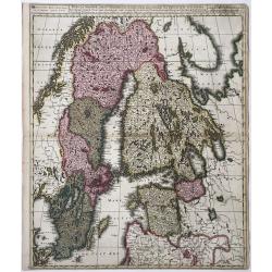
Sueciae Magnae, totius Orbis Regni antiquissimi, hodierna in sex Principales suas partes, Gothiam nempe, Sueciam propriam sive strictae Sumptam, Nordlandiam, Ingriam, Livoniam', and impressum...
Map of Greater Sweden: Sweden, Finland, Estonia, Latvia. From: Atlas sive Geographia compendiosa ... / Atlas Nouveau contenant tous les partis du Monde (Composite Atlas),...
Date: Amsterdam, ca. 1745
Selling price: ????
Please login to see price!
Sold in 2022
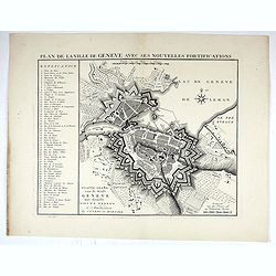
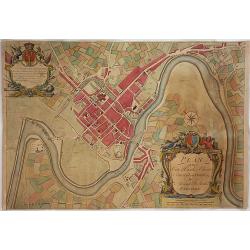
Plan de la ville de Geneve, avec ses nouvelles Fortifications.
A beautifully engraved, highly decorative map showing all of Geneva extended to Leman lake, with excellent map detail throughout. Major cities and towns, with regional ro...
Date: Amsterdam, ca 1745
Selling price: ????
Please login to see price!
Sold in 2022
Casaniae Regnum cum Adiacentibus Provinciis et Parte Fluvii Volgae.
From the first regional atlas of Russia, published by the Academy of Sciences in St. Petersburg, expanding on the cartographic work done previously by Ivan K. Kirilov. Ou...
Date: Academy of Sciences, St. Petersburg, 1745
Selling price: ????
Please login to see price!
Sold in 2025
![[Lot of 11 maps of Russia]](/uploads/cache/48304-250x250.jpg)
[Lot of 11 maps of Russia]
Lot of 11 maps of Russia, diiferent size, diofferent dates.
Date: Augsburg, 1745
Selling price: ????
Please login to see price!
Sold in 2022
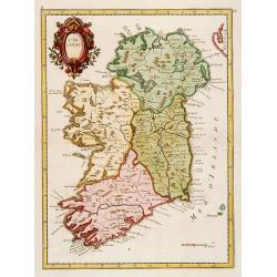
L'Irlande.
Fine map of Ireland.
Date: Paris 1746
Selling price: ????
Please login to see price!
Sold
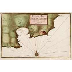
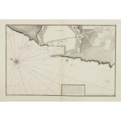
Plan de la Baye de Nagaye.
Prepared by Jacques Ayrouard and engraved by Louis Corne. Decorated with a large compass rose. From the rare chart book by Jacques Ayrouard: Recueil de plusieurs Ports .....
Date: Marseille, 1732 - 1746
Selling price: ????
Please login to see price!
Sold
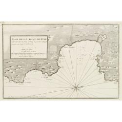
Plan de la Baye de Rose et des Côtes des environs de puis le port de Cadequié jusques au Cap St. Sebastien..
Coastal chart illustrating part of the Spanish Catalan country seacoast. It covers the area from south of Begur to today Cadaqués, close to the French border.From the ra...
Date: Marseille, 1732 - 1746
Selling price: ????
Please login to see price!
Sold
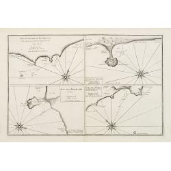
![[Untitled Front views of the coastal relief of Provence]](/uploads/cache/23302-250x250.jpg)
[Untitled Front views of the coastal relief of Provence]
Copper engraving presenting separate front views of the coastal relief of Provence divided in stripes.It covers the area which extends from Cap Sicié as far as Monaco, i...
Date: Marseille, 1732 - 1746
Selling price: ????
Please login to see price!
Sold
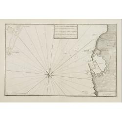
![[5 charts of Spanish coasts and harbours.] Plan du Port et Rade ... Jacques Ayrouard](/uploads/cache/23140-250x250.jpg)
[5 charts of Spanish coasts and harbours.] Plan du Port et Rade ... Jacques Ayrouard
A set of 5 coastal charts from the rare chart book by Jacques Ayrouard: Recueil de plusieurs Ports ... de la Mer Mediterranie.Plan du Port et Rade de Palamos en Catalogne...
Date: 1732-1746
Selling price: ????
Please login to see price!
Sold
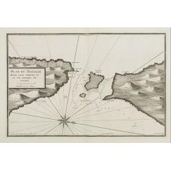
Plan du Passage du Fort Brescon - Plan de la Rade de..
Four charts on one plate : Plan du Passage du Fort Brescon.. - Plan de la Rade de Peniscola en Valence.- Plan de la Rade de Carpi en Valence.- Plan de la Rade de Benidorm...
Date: 1732-1746
Selling price: ????
Please login to see price!
Sold
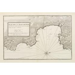
Plan de la Baye de Rose et des Côtes des environs de puis le port de Cadequié jusques au Cap St. Sebastien..
Uncommon chart illustrating part of the Spanish Catalan country seacoast. It covers the area from south of Begur to today Cadaqués, close to the French border.From the r...
Date: Marseille 1732 -1746
Selling price: ????
Please login to see price!
Sold
![[Untitled Front views of the coastal relief of the Gulf of Valencia as far as Catalonia]](/uploads/cache/23947-250x250.jpg)
[Untitled Front views of the coastal relief of the Gulf of Valencia as far as Catalonia]
Copper engraving presenting separate front views of the southeastern coastal relief of Spain divided in stripes.Covering the area which extends from the Gulf of Valencia ...
Date: Marseille 1732 - 1746
Selling price: ????
Please login to see price!
Sold
![[Untitled] Front views of the coastal relief of Sardinia.](/uploads/cache/24831-250x250.jpg)
[Untitled] Front views of the coastal relief of Sardinia.
Copper engraving presenting separate front views of the coastal relief of Sardinia and the Ponziane Islands, divided in stripes.From the rare chart book by Jacques Ayroua...
Date: Marseille, 1732 - 1746
Selling price: ????
Please login to see price!
Sold in 2009
![[Untitled] Front views of the Riviera.](/uploads/cache/24832-250x250.jpg)
[Untitled] Front views of the Riviera.
Copper engraving presenting separate front views of the Italian Riviera.It covers the whole Gulf of Genoa and Monaco.From the rare chart book by Jacques Ayrouard: Recueil...
Date: Marseille, 1732 - 1746
Selling price: ????
Please login to see price!
Sold
![[Untitled] Front views of the coastal relief of Corsica and Tuscany.](/uploads/cache/24834-250x250.jpg)
[Untitled] Front views of the coastal relief of Corsica and Tuscany.
Copper engraving presenting separate front views of the coastal relief of northern Corsica and the facing Tuscan shores, divided in stripes.From the rare chart book by Ja...
Date: Marseille, 1732 - 1746
Selling price: ????
Please login to see price!
Sold
![[Untitled] Front views of the Tyrrhenian coastal relief of Italy.](/uploads/cache/24835-250x250.jpg)
[Untitled] Front views of the Tyrrhenian coastal relief of Italy.
Copper engraving presenting separate front views of the coastal relief of Italy between Tuscany and Campania with its Tyrrhenian islands, divided in stripes.From the rare...
Date: Marseille, 1732 - 1746
Selling price: ????
Please login to see price!
Sold in 2009
![[Untitled] Front views of the Italian coastal relief.](/uploads/cache/24836-250x250.jpg)
[Untitled] Front views of the Italian coastal relief.
Copper engraving presenting separate front views of the Tyrrhenian as well as Ionian coastal relief of Italy, divided in stripes.From the rare chart book by Jacques Ayrou...
Date: Marseille, 1732 - 1746
Selling price: ????
Please login to see price!
Sold in 2009
![[Untitled] Front views of the Spanish coastal relief.](/uploads/cache/24838-250x250.jpg)
[Untitled] Front views of the Spanish coastal relief.
Separate front views mainly depicting the coastal relief of Catalonia, divided in stripes.From the rare book by Jacques Ayrouard: Recueil de plusieurs Ports .. de la Mer...
Date: Marseille 1732 - 1746
Selling price: ????
Please login to see price!
Sold
![[Untitled] Front views of the coastal relief of the French Riviera.](/uploads/cache/24840-250x250.jpg)
[Untitled] Front views of the coastal relief of the French Riviera.
Separate front views depicting the coastal relief of French Riviera, divided in stripes.It covers the littoral zone between Monaco as far as the Iles Hyères.From the rar...
Date: Marseille, 1732 - 1746
Selling price: ????
Please login to see price!
Sold
Plan du Passage Entre L isle Azinara et le Cap Azinara de Sardaigne.
Copper engraving depicting the northwestern tip of Sardinia and the southern tip of the Asinara Island.Oriented with West on top. Decorated with a large compass rose.From...
Date: Marseille, 1732 - 1746
Selling price: ????
Please login to see price!
Sold
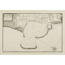
Plan du Port et Rade de Livourne..
Copper engraving showing the harbor and roadstead of Livorno with the adjacent seashores. Decorated with a large compass rose.From the rare chart book by Jacques Ayrouard...
Date: Marseille, 1732 - 1746
Selling price: ????
Please login to see price!
Sold in 2009
Plan du Port et Rade de Livourne..
Copper engraving centered on the harbour and roadstead of Livorno. Decorated with a large compass rose.From the rare chart book by Jacques Ayrouard: Recueil de plusieurs ...
Date: Marseille, 1732 - 1746
Selling price: ????
Please login to see price!
Sold in 2015
Plan du Port de Civita-Vechia. . .
Large plan of the harbour in Civitavecchia. Decorated with a large compass rose.From the rare chart book by Jacques Ayrouard: Recueil de plusieurs Ports .. de la Mer Méd...
Date: Marseille, 1732 - 1746
Selling price: ????
Please login to see price!
Sold in 2015
![[Untitled] Front views of the Italian coastal relief.](/uploads/cache/24848-250x250.jpg)
[Untitled] Front views of the Italian coastal relief.
Copper engraving presenting separate front views of the Tyrrhenian as well as Ionian coastal relief of Italy, divided in stripes.From the rare chart book by Jacques Ayrou...
Date: Marseille 1732 - 1746
Selling price: ????
Please login to see price!
Sold
Lot of four maps showing Siberia and parts of Northern Russia.
Carte de la Siberie . ., 1754. Detailed overview of Siberia, showing cities, towns, mountainous and forested areas, and the region's numerous rivers. Route tracks of the...
Date: Paris, ca.1746
Selling price: ????
Please login to see price!
Sold in 2008
![[Untitled] Front views of the Spanish coastal relief.](/uploads/cache/28217-250x250.jpg)
[Untitled] Front views of the Spanish coastal relief.
Separate front views depicting great part of the Mediterranean coast of Spain, including Brescon, divided in stripes.It covers the littoral zone between Peñíscola and G...
Date: Marseille, 1732 - 1746
Selling price: ????
Please login to see price!
Sold in 2010
Plan de la Baye et Port de Mayorque. par Jacques Ayrouard pilote real et gravé par Louis Corne.
Large plan of the harbour Majorca. Decorated with a large compass rose.From the rare chart book by Jacques Ayrouard: "Recueil de plusieurs plans des ports et rades e...
Date: Marseille 1732-1746
Selling price: ????
Please login to see price!
Sold in 2010
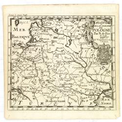
Estats de la Couronne de Pologne.
An interesting small map of the Poland by Nicolas de Fer. From Jacques Robbe’s "Methode pour Apprendre Facilement la Geographie". The map has a scale to 20 ho...
Date: Paris,1746
Selling price: ????
Please login to see price!
Sold in 2011
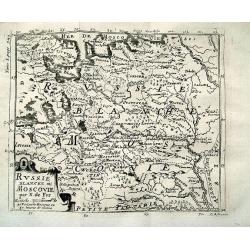
RUSSIE BLANCHE OU MOSCOVIE par N. de Fer
Charming map of North-Eastern Europe and parts of Russia. Includes Riga, Moscow, Novgorod, Samara, the Volga river, the White Sea, etc. Very detailed map with many plac...
Date: Paris, 1746
Selling price: ????
Please login to see price!
Sold in 2012
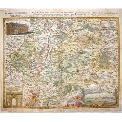
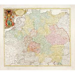
Hassiae Superioris et Wetterau, Paris Delineatio.
Copper engraving By Homann Heirs, dated 1746. Original hand coloring with recent coloring added to border & cartouches.Giessen is located in the center of this detail...
Date: Nuremberg, 1746
Selling price: ????
Please login to see price!
Sold in 2017
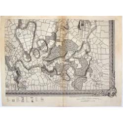
A Map of London and the Adjacent Country 10 Miles Around - (Sheet 1 of 16).
This is a part of an exact Survey of the City of London Westminster, ye Borough of Southwark and the country near ten miles round, begun in 1741 and ended in 1745, by Joh...
Date: London, 1746
Selling price: ????
Please login to see price!
Sold in 2020

Vue du Chateau Royal de Frederichsberg Vers la Cour.
A striking view of Fredericksberg Castle in Copenhagen. From "Den Danske Vitruvius", a richly illustrated 18th-century architectural work on Danish monumental b...
Date: Germany, 1746
Selling price: ????
Please login to see price!
Sold in 2020
La Moscovie.
Fine original colored map of Russia in Europe by George Louis La Rouge.
Date: Paris, 1746
Selling price: ????
Please login to see price!
Sold in 2015
Partie de la Mer Glaciale Contenant la Nouvelle Zemble et le Pais des Samoiedes.
A detailed map of Nova Zembla and part of the northeast passage in northern Russia. It includes a decorative title cartouche. Produced by Bellin for the L'Histoire Genera...
Date: Paris, 1746
Selling price: ????
Please login to see price!
Sold in 2018
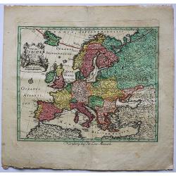
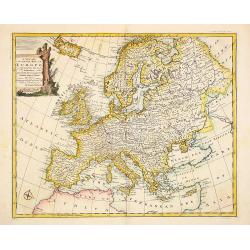
Novae Europae Delineatio.​
A decorative old colored copper engraved map by Peter Conrad Monath. This interesting map shows the continent of Europe with the Christian countries of Scandinavia, Great...
Date: London, 1746
Selling price: ????
Please login to see price!
Sold in 2018
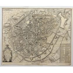
Brussels.
Fine detailed plan of the city of Brussels in Belgium, including fortifications, town plan, roads, farms, rivers and a decorative cartouche with arms, city crest and topp...
Date: London, 1746
Selling price: ????
Please login to see price!
Sold in 2018
A correct Chart of the German Ocean, from the North of Scotland to the Start Point. . .
A chart of the German Ocean published in Nicholas Tindal’s continuation of Rapin de Thoyras’s “History of England”, it includes compass rose and a large decorativ...
Date: London, 1746
Selling price: ????
Please login to see price!
Sold in 2019
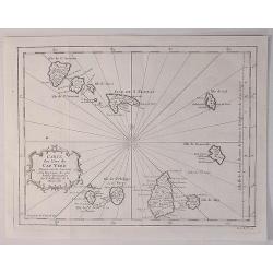
Carte des Isles du Cap Verd.
A decorative example of Bellin's map of the Cape Verde Islands, that features a decorative cartouche and compass rose.Jacques-Nicolas Bellin (1703-1772) was among the mos...
Date: Paris, 1746
Selling price: ????
Please login to see price!
Sold in 2020
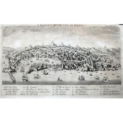
A Prospect of the City of Genoa.
A highly detailed birds-eye view of Genoa. Withy numerous buildings and landmarks of the surrounding area shown. The harbour is filled with sailing ships. A key below nam...
Date: London, ca 1746
Selling price: ????
Please login to see price!
Sold in 2022
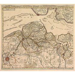
Nieuwe Kaart .. Westelykste Gedeelte van Staats-Vlaanderen
Detailed map of the Westerschelde delta, including Zeeuws Vlaanderen. Isaac Tirion was born in Utrecht ca. 1705. He came to Amsterdam ca. 1725. Tirion published a number ...
Date: Amsterdam 1747
Selling price: ????
Please login to see price!
Sold
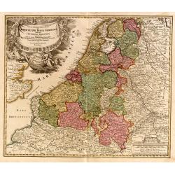
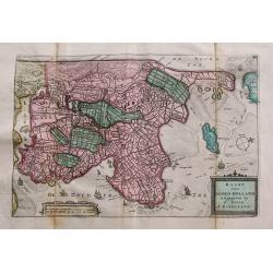
Tabula Generalis.. Provinciae XVII. Infer. Germaniae..
A decorative map with uncolored cartouche surrounded by the coats of arms of Brabant, Limburg, Luxembourg, Geldern, Holland, Zeeland, Zutphen, Flandria, Flanders, Artois,...
Date: Nuremberg 1747
Selling price: ????
Please login to see price!
Sold
Imperii Romano Germanici..
Johann Baptist Homann's well-engraved map of the Roman Empire with a large decorative cartouche.
Date: Nuremberg, 1747
Selling price: ????
Please login to see price!
Sold
A new and very accurate map of Europe..
General map of Europe, with an elegant baroque title cartouche. Engraved by Emanuel Bowen. In lower left corner, plate number 36.
Date: London 1747
Selling price: ????
Please login to see price!
Sold
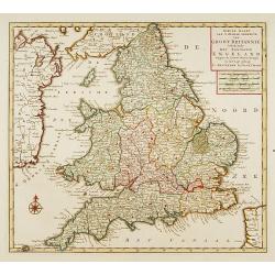
Nieuwe kaart van 'T zuider Gedeelte van Groot Brittannie. . .
Isaac Tirion was born in Utrecht ca. 1705. He came to Amsterdam ca. 1725. Tirion published a number of important books, many of which are still in demand for their intere...
Date: Amsterdam, 1747
Selling price: ????
Please login to see price!
Sold in 2023