Browse Listings in Asia > South East Asia
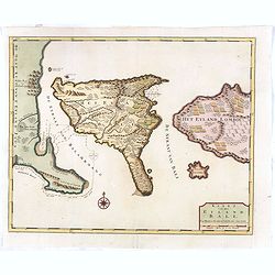
Kaart van het eyland Bali.
Fine map depicting the Island Bali, with part of the coasts of Java and Lomboc. Good interior detail is given with settlements, roads, etc. An attractive early map, one o...
Date: Amsterdam, 1726
Selling price: ????
Please login to see price!
Sold in 2016
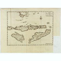
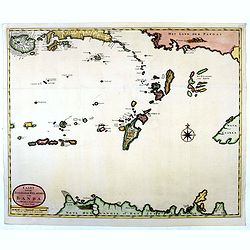
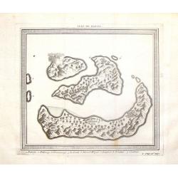
Kaart van de Zuyd-Wester Eylanden van Banda.
Map of the Banda islands.François Valentijn (1666-1727), a missionary, worked at Amboina from 1684 to 1694 and 1705 to 1713 and travelled extensively in the VOC's lands....
Date: Amsterdam, 1726
Selling price: ????
Please login to see price!
Sold
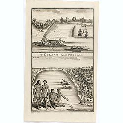
'T Eylant Amsterdam
Two engravings on one sheet showing the native boats and peoples of Amsterdam Island in the Banda Islands of Indonesia. Dutch (V.O.C.) sailing ships and various local cra...
Date: Amsterdam, 1726
Selling price: ????
Please login to see price!
Sold in 2019
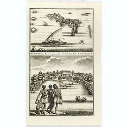
Anamocka by ons genaemt 'T Eylant Rotterdam.
Two engravings on one sheet showing the boats and peoples of Anamocka Island in the islands of Tonga.François Valentijn (1666-1727), a missionary, worked at Amboina from...
Date: Amsterdam, 1726
Selling price: ????
Please login to see price!
Sold in 2018
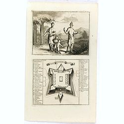
Macassaarsche Man en Vrouw / 't Casteel Rotterdam op Maccasar.
Two engravings on one sheet showing a man and woman from Macassar and a plan of the Rotterdam Fort in Macassar (now Ujung Pandang) on the island of Sulawesi.François Val...
Date: Amsterdam, 1726
Selling price: ????
Please login to see price!
Sold in 2016
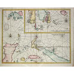
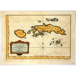
Kaart van de Zuyd-Ooster Eylanden van Banda.
Map of the Banda islands. In the lower part of the map early out lines of Australia with van Diemens Land.François Valentijn (1666-1727), a missionary, worked at Amboina...
Date: Amsterdam, 1726
Selling price: ????
Please login to see price!
Sold in 2018
De Landvoogdy der Moluccos met de aangrenzende Eylanden.
Fine chart depicting the Moluccas islands and the northern part of Celebes, nowadays Sulawesi with an inset depicting the southern part of Celebes with the island Bouro.L...
Date: Amsterdam, 1728
Selling price: ????
Please login to see price!
Sold
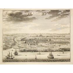
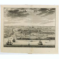
Atsjien.
From Francois Valentyn's Oud en Nieuw Oost Indien, part V : Beschryving van Coromandel, Pegu, Arrakan, Bengale, Mocha, Persien, Malakka, Sumatra, Ceylon.A bird's eye-view...
Date: Amsterdam, 1728
Selling price: ????
Please login to see price!
Sold
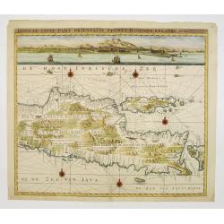
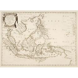
Insulae Iava Pars Orientalis Edente Hadriano Relando..
A finely engraved and detailed map of eastern part of Java important for its Dutch trading connections.With an inset panoramic view of Batavia. The map clearly indicates ...
Date: Amsterdam 1728
Selling price: ????
Please login to see price!
Sold

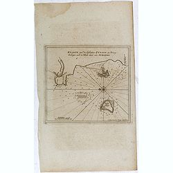
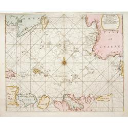
Van Keulen Map of the Pisang Islands on the West Coast of Sumatra.
Very rare chart of Pisang Island, a small island near Padang, on the west coast of Sumatra, Indonesia. Oriented to the west, this map covers the coast of Padang, and the ...
Date: Amsterdam, 1728
Selling price: ????
Please login to see price!
Sold in 2015
Atsjien.
From Francois Valentyn's "Oud en Nieuw Oost Indien, part V : Beschryving van Coromandel, Pegu, Arrakan, Bengale, Mocha, Persien, Malakka, Sumatra, Ceylon."A bir...
Date: Amsterdam, 1728
Selling price: ????
Please login to see price!
Sold in 2015
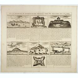
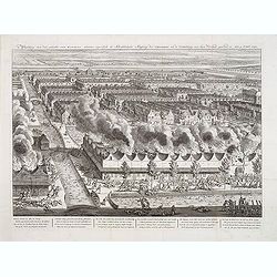
Vue et description de quelques-uns des principaux forts des Hallandois dans les Indes.
Interesting sheet with seven detailed views illustrating the most important Dutch trading outposts and fortified colonial possessions in South East Asia, including 4 harb...
Date: Amsterdam, 1728
Selling price: ????
Please login to see price!
Sold in 2018
Kaarte van de Eylanden Pysang, by Padang. Gelegen aan de West kust van Sumatra.
Very rare chart of Pisang Island, a small island near Padang, on the west coast of Sumatra, Indonesia. Oriented to the west, this map covers the coast of Padang, and the ...
Date: Amsterdam, 1728
Selling price: ????
Please login to see price!
Sold in 2017
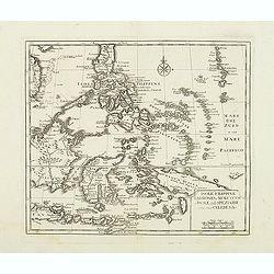
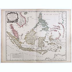
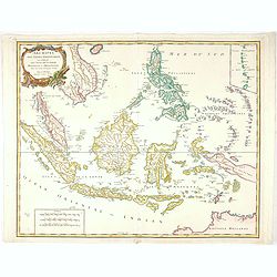
The Island of Celebes, or Macassar with the Islands of Banda, Amboyna. . .
A detailed map of the islands from Eastern Brunei to Timor and part of New Guinea, centered on the Moluccas, including the famous Spice Islands that were once the heart o...
Date: London, ca. 1730
Selling price: ????
Please login to see price!
Sold in 2019
Plan de la Ville et du Chateau de BATAVIA en l'Isle de Iava (JAKARTA).
A detailed east oriented Dutch plan of Jakarta (former Batavia) in Java / Indonesia. With a bird eye view from the sea side, with various ships and a lion. Two inset keys...
Date: Leiden, 1730
Selling price: ????
Please login to see price!
Sold in 2019
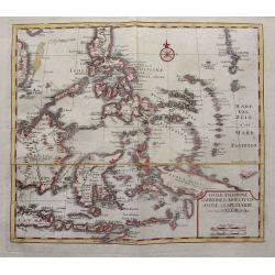
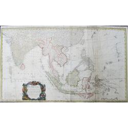
India Orientalis cum Adjacentibus Insulis Nova. . .
A superlative example of Seutter's scarce map of the East Indies showing part of Australia, from the famous "Atlas Novus". The map covers a large region extendi...
Date: Augsberg, 1730
Selling price: ????
Please login to see price!
Sold in 2020
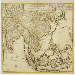
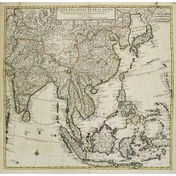
Carte des Indes et de la Chine..
Early edition of this large and attractive map of South East Asia, India, Japan, Korea and China.The map is of interest for the use of Mer Orientale ou Mer de Corée, for...
Date: Paris, 1731
Selling price: ????
Please login to see price!
Sold in 2015
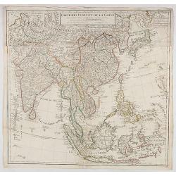
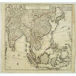
Carte des Indes et de la Chine. . .
Early edition of this large and attractive map of South East Asia, India, Japan, Korea and China.The map is of interest for the use of Mer Orientale ou Mer de Corée, for...
Date: Paris, 1731
Selling price: ????
Please login to see price!
Sold in 2020
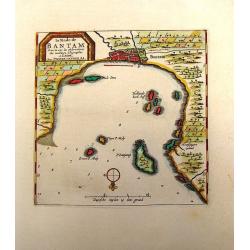
La Rade de Bantam.
Map of the Bay of Bantam on Java. Decorated with a frame cartouche. Pieter van der Aa (1659 - 1733) was a Dutch publisher best known for preparing maps and atlases. He a...
Date: Amsterdam, 1732
Selling price: ????
Please login to see price!
Sold in 2014
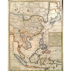
A map of the continent of the East-Indies &c. Containing the territories, settlements, and factories of the Europeans. Explaining what belongs to England, France, Holland, Denmark, Portugal &c. By H. Moll Geographer. Printed and sold by T. Bowles next ye
Map of the Continent of the East-Indies &c. Containing the Territories, Settlements, and Factories of the Europeans. Explaining what belongs to England, France, Holla...
Date: London, 1732
Selling price: ????
Please login to see price!
Sold in 2014
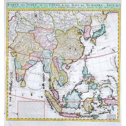
Carte des Indes, de la Chine & des Isles de Sumatra, Java &c.
Fine map of South East Asia.Zacharie Chatelain (d.1723) was the father of Henri Abraham (1684-1743) and Zacharie Junior (1690-1754).They worked as a partnership publishin...
Date: Amsterdam, 1719-1732
Selling price: ????
Please login to see price!
Sold in 2019
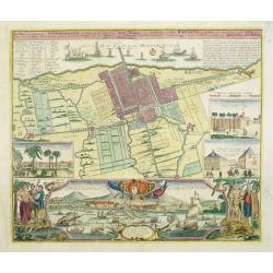
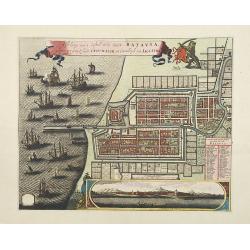
Der Hollaendisch-Ostindianischen Compagnie Weltberühmte Haupt - Handels und Niederlags stadt BATAVIA..
Very fine decorative town-plan of Batavia (Jakarta) showing the City and its immediate environs, the surrounding rice fields intersected by a network of waterways, canals...
Date: Nuremberg, 1733
Selling price: ????
Please login to see price!
Sold in 2012
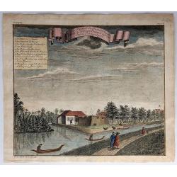
Ein Prospect der Baterie Anjol Eine Stunde von Batavia...
A pleasing view of the battery in Batavia, Indonesia. Batavia was the name of the capital city of the Dutch East Indies, and corresponds to the present-day city of Jakart...
Date: Frankfurt, 1739
Selling price: ????
Please login to see price!
Sold in 2018
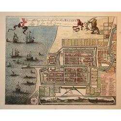
Waere Affbeeldinge Wegens het Casteel ende Stadt Batavia Gelegen opt Groot Eylant Java.
Batavia (Jakarta), the Dutch capital in the East Indies, is an exquisite and detailed plan. The plan is based on Clement de Jonghe's map of 1650, except for a modificatio...
Date: Amsterdam, 1740
Selling price: ????
Please login to see price!
Sold in 2010
Vue de la Bastion de Gelderland, hors de la Ville Batavia.
Complete title : Vuë de la bastion de Gelderland hors de la ville Batavie [mirror-reversed] / Collection des Prospects / Prospect von der Bastion Gelderland ausserhalb d...
Date: Augsburg, 1740
Selling price: ????
Please login to see price!
Sold in 2010
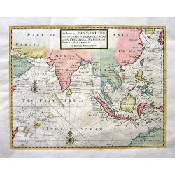
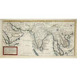
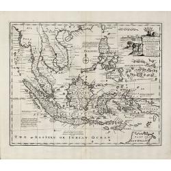
A Chart of ye EAST-INDIES, With the Coast of Persia, China also the Philipina, Moluca and Sunda Islands &c.
A very decorative chart of the Indian Ocean. The map extends until Saudi Arabia and Madagascar in the West, and Australia, New Guinea, and Japan in the East. Shows a part...
Date: London, c.1740
Selling price: ????
Please login to see price!
Sold in 2009
Afbeldinge van het casteel en de stadt Batavia. . .
Copied after Clement de Jonghe's map of 1650. Map of Jakarta, head quarters of the V.O.C.Joachim Ottens (1663 - 1719) and his sons Renier and Joshua were prominent Dutch ...
Date: Amsterdam, 1740
Selling price: ????
Please login to see price!
Sold in 2011
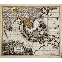
India Orientalis
First state (before the privilege, which was granted not before 1740). Map of South-East Asia showing the area between India in the West and Japan and Australia in the Ea...
Date: Augsburg, c. 1730-1740
Selling price: ????
Please login to see price!
Sold in 2014
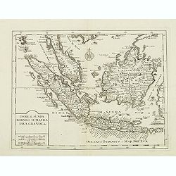
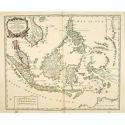
Isole di Sunda Borneo Sumatra Iava Grande. . .
The Malay Peninsula and Singapore, Sumatra, Java and Borneo.From "Atlante Novissimo Che Contiene Tutte Le Parti Del Mondo...." This atlas was published in Venic...
Date: Venice, 1740
Selling price: ????
Please login to see price!
Sold in 2012
Isole Filippine Ladrones e Moluccos o Isole delle speziarie come anco Celebes. . .
The East Indies from Philippines south to New Guinea and Timor.From "Atlante Novissimo Che Contiene Tutte Le Parti Del Mondo…." This atlas was published in Ve...
Date: Venice, 1740
Selling price: ????
Please login to see price!
Sold in 2014
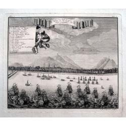
Afbeelding van dat gedeelte van BATAVIA, alwaar eigentlyk de Schrikkelyke Slagting der CHINEZEN, na de Ontdekking van hun Verraad, geshied is, den 9. Octob: 1740.
Very rare bird's-eye view of part of the city of Batavia, houses burning in foreground, canals filled with dead and drowning bodies and massacre of Chinese in progress on...
Date: B. Mourik, after 1740
Selling price: ????
Please login to see price!
Sold in 2013
Isole di Sunda Borneo Sumatra Iava Grande. . .
The Malay Peninsula and Singapore, Sumatra, Java and Borneo. From "Atlante Novissimo Che Contiene Tutte Le Parti Del Mondo…." This atlas was published in Veni...
Date: Venice, 1740
Selling price: ????
Please login to see price!
Sold in 2015
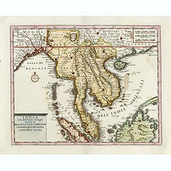
India di la del Fiume Ganges overo di Malacca Siam Cambodia Chiampa KoChinkina Laos Pegu ava&c..
Fine map of Malay Peninsular, with present-day Thailand, the Straits of Singapore and Borneo in the South to China in the east and the Bay of Bengal in the south, edited ...
Date: Venice, 1740
Selling price: ????
Please login to see price!
Sold in 2017
Isole Filippine, Ladrones, e Moluccos o Isole della Speziarie come anco Celebes &c.
Scare map of Southeast Asia with Borneo, Bali, the Philippines, New Guinea, Timor, etc. Very detailed naming even smallest islands. From an Italian edition of Thomas Salm...
Date: Venice, c1740
Selling price: ????
Please login to see price!
Sold in 2015
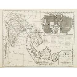
Carte des Indes orientales dressee sur les observations de l'Academie Royale des Sciences, et sur les memoires de la Compagnie des Indes.
Uncommon map of South East Asia, with in upper right corner inset "Plan de Pondicherry en 1741", with a key A-S, 1-21. Engraved by F.Desbruslins. Scale ca. 1:25...
Date: Paris, Jean Desaint & Charles Saillant, 1744
Selling price: ????
Please login to see price!
Sold in 2008
![No title. [South East Asia]](/uploads/cache/36593-250x250.jpg)
No title. [South East Asia]
Including Indonesia, India, Java, Sumatra, Japan, Taiwan and North coast of Australia. Rare, from Allerneuster geographisch- und topographischer Schau-Platz von Africa un...
Date: Germany, 1744
Selling price: ????
Please login to see price!
Sold in 2015
Ein Prospect der Stadt Batavia, wie sich dieselbe von der Reede oder dem Hafen praesentiret.
An uncommon view of Batavia (today known as Jakarta) shown from the sea, which was the main city of the Dutch East India Company (the VOC). The harbour is filled with sai...
Date: Nuremberg, 1744
Selling price: ????
Please login to see price!
Sold in 2018
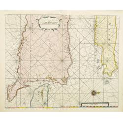
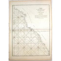
A large Draught of the East End of Java and Madura. . .
Oriented with west at the top, this large-scale and detailed chart of the Bali Strait and Java Sea, shows the eastern ends of Java and Madura, and the western end of Bali...
Date: London 1745
Selling price: ????
Please login to see price!
Sold in 2023
Les Isles Philippines Molucques et de la Sonde.
An uncommon late printing of Sanson's important mid-seventeenth century map of the East Indies, covering modern Indonesia, the Philippines, Malaysia and parts of Southeas...
Date: Paris 1654/c.1745
Selling price: ????
Please login to see price!
Sold
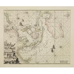
A large Draught from Benjar on the Island of Borneo..
A later edition, printers address erased from the title cartouche. Latitude scale, compass rose and system of rhumb lines, soundings near coast.
Date: London 1745
Selling price: ????
Please login to see price!
Sold
Carte des Indes et de la Chine Dressée..
Large and attractive map of the East Indes, India and China.The map is from a Dutch edition of De L'Isle's work entitled, Atlas Nouveau, Contenant Toutes Les Parties Du M...
Date: Amsterdam c. 1745
Selling price: ????
Please login to see price!
Sold
Orientaliora Indiarum Orientalium. . .
This is a corrected version of De Wit. Tasmania is inserted, and New Britain with Dampier's route 1700, now changes the shape of New Guinea. The chart has also been corre...
Date: Amsterdam, 1745
Selling price: ????
Please login to see price!
Sold in 2008
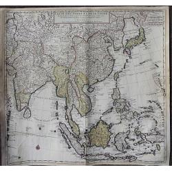
Carte des Indes et de la Chine Dressée . . .
Large and attractive map of South East Asia, India and China.The map is of interest for the use of East Sea, the sea between Korea and Japan, here called "Mer Orient...
Date: Amsterdam, c. 1745
Selling price: ????
Please login to see price!
Sold
Carte des Indes et de la Chine Dressée . . .
Large and attractive map of South East Asia, India and China.The map is of interest for the use of East Sea, the sea between Korea and Japan, here called "Mer Orient...
Date: Amsterdam, c. 1745
Selling price: ????
Please login to see price!
Sold in 2012
Carte de la Cote Occidentale de L'isle Sumatra.
Coastal Map of West Sumatra, an island in Western Indonesia. It is from Le Neptune Oriental. Jean-Baptiste d'Après de Mannevillette (1707-1780) was a French sailor, nav...
Date: Paris, 1745
Selling price: ????
Please login to see price!
Sold in 2018
Carte des Indes et de la Chine Dressée. . .
A large, important, and very decorative map of South East Asia, India and China.The map is particularly interesting due to the appearance of the sea between Korea and Jap...
Date: Amsterdam, ca. 1745
Selling price: ????
Please login to see price!
Sold in 2020
Carte réduite de l'archipel des Indes orientales avec les côtes du continent depuis le golfe de Manar jusqu'à Emoui à la Chine . . .
Important French chart of South East Asia with very good detail on Philippines. Latitude and longitude scales, compass rose and system of rhumb lines, soundings near coas...
Date: Paris, 1745
Selling price: ????
Please login to see price!
Sold in 2017
Suite De L'Ocean Oriental.. Chine Les Isles Du Japon..
Fine map of South East Asia, New Guinee, coast of China, Korea and Japan. Several coastal towns noted, but little depicted in the interior.Japan is shown in Bellin's dist...
Date: Paris 1746
Selling price: ????
Please login to see price!
Sold
Fortsetzung der Karte von dem Morgenlaendischen Ocean die Eylande Sonda die Küsten von Tunquin und China die Eylande Japon.
Interesting and detailed map of Southeast Asia by Nicolas Bellin. Showing the Philippines, Indonesia, Japan, the east coast of China and parts of Papua New Guinea. With a...
Date: Leipzig, Arkstee & Merkus, 1746
Selling price: ????
Please login to see price!
Sold in 2009
Fortsetzung der Karte von dem Morgenlaendischen Ocean die Eylande Sonda die Küsten von Tunquin und China die Eylande Japon
Interesting and detailed sea chart of Southeast Asia by Nicolas Bellin. Showing the Philippines, Indonesia, Japan, the east coast of China and parts of Papua New Guinea. ...
Date: Leipzig, 1746
Selling price: ????
Please login to see price!
Sold in 2010
A New and Accurate Map of the East India Islands
Bowen's map of Southeast Asia from 'A Complete System of Geography'. With an elaborate allegorical cartouche and a compass rose. Includes the Philippines and part of Aust...
Date: London, 1747
Selling price: ????
Please login to see price!
Sold in 2010
A Map of China, Japan, Tonquin, Cochin-China and Siam.
Uncommon map of South East Asia engraved by R.W. Seale.
Date: London, c. 1747
Selling price: ????
Please login to see price!
Sold in 2012
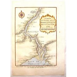
Carte du Cours de la Riviere de Tunquin.
Handsome hand colored map of the Tonkin River from Ho Chi Mingh to the Gulf of Tonkin. The map provides fine detail of the region and is embellished with a compass rose a...
Date: Paris, 1747
Selling price: ????
Please login to see price!
Sold in 2015
A new & accurate map of the Empire of the Great Mogul.
A decorative map of India, Central Asia, Siam, the Straits of Malacca and parts of Borneo, Sumatra and China, it also incudes the Maldives and the Andaman Islands. It inc...
Date: London, 1747
Selling price: ????
Please login to see price!
Sold in 2021
![[2-sheets] Carte des Indes Orientales. . .](/uploads/cache/39110-250x250.jpg)
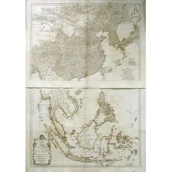
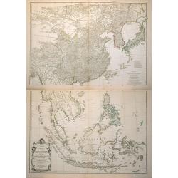
[2-sheets] Carte des Indes Orientales. . .
A lovely two sheet map (1000 x 860 mm) of the East Indies, drawn by Tobias Meyer for the Homann Heirs in 1748.The first sheet shows India as far north as Delhi, across to...
Date: Nurenberg, 1748
Selling price: ????
Please login to see price!
Sold in 2017
Carte des Indes Orientales...
Important and large size copper-engraved map from India until Australia. Including todays Burma, Thailand, Laos, Vietnam, Malaysia, Singapore, Sumatra, Bali, China, Taiwa...
Date: Nuremberg, 1748
Selling price: ????
Please login to see price!
Sold in 2019
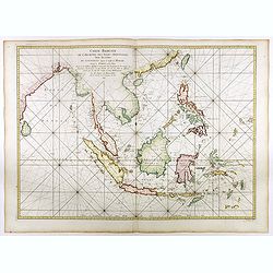
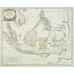
Archipel Des Indes Orientales, qui comprend Les Isles De La Sonde.. Philippines..
Good condition. Some marginal water stains. Paper very slightly age toned. Very good.
Date: Paris, 1750
Selling price: ????
Please login to see price!
Sold in 2015
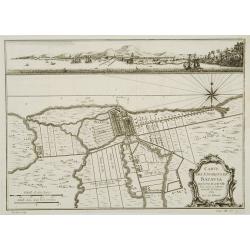
Carte des environs de Batavia avec la vuë de cette ville.
Map of Jakarta and surroundings with a separate view on top.From Prévost's important Collection of Voyages.
Date: Paris, 1750
Selling price: ????
Please login to see price!
Sold
Carte des Isles de Java, Sumatra Borneo & Les Détroits de la Sonde Malaca et Banca Golphe de Siam.
Bellin's map of the Indonesian archipelago, also depicting Malaysia. Jacques Nicolas Bellin (1702-720) was the most important French hydrographer of the 18th century. He ...
Date: Paris, c. 1750
Selling price: ????
Please login to see price!
Sold in 2019
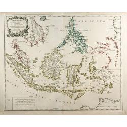
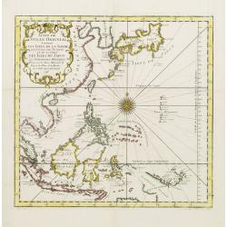
Archipel Des Indes Orientales, qui comprend Les Isles De La Sonde ... Philippines ...
An attractive and detailed view of the Indonesian islands in large format. Decorative title cartouche.
Date: Paris, 1750
Selling price: ????
Please login to see price!
Sold in 2009
Archipel Des Indes Orientales, qui comprend Les Isles De La Sonde.. Philippines..
An attractive and detailed view of the Indonesian islands in large format. Decorative title cartouche.
Date: Paris, 1750
Selling price: ????
Please login to see price!
Sold in 2011
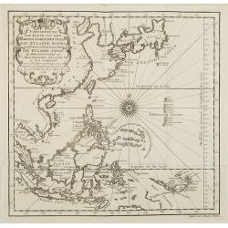
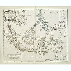
Archipel Des Indes Orientales, qui comprend Les Isles De La Sonde.. Philippines..
An attractive and detailed view of the Indonesian islands in large format and Malacca and Southern China to the Philippines, New Guinea and Northern Australia. Includes a...
Date: Paris, 1750
Selling price: ????
Please login to see price!
Sold in 2013
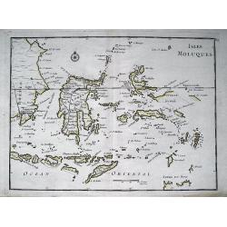
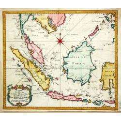
ISLES MOLUQUES.
Highly detailed map of the famous Spice Islands (Maluku Islands or the Moluccas). Includes also Sulawesi, Bali, Timor, part of Borneo, New-Guinea with unfinished coast li...
Date: Paris, c1750
Selling price: ????
Please login to see price!
Sold in 2013

Carte des Isles Voisines des Moluques.
Map of the province of Moluccas, Indonesia including Ceram, Bouro, Amboine and Neyra. Published by Pierre de Hondt for Prevost's "L'HISTOIRE GENERALE DES VOYAGES&quo...
Date: Paris, ca.1750
Selling price: ????
Please login to see price!
Sold in 2016
Isles de Banda.
Striking map of the Indonesian Islands of Banda including Pulorin, Puloway, Gunnanapi, Labetak, Nera etc. It was engraved by Didot in Paris in 1750.
Date: Paris, 1750
Selling price: ????
Please login to see price!
Sold in 2014
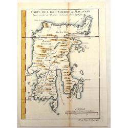
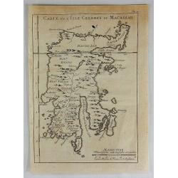
Carte de L'Isle Celebes ou Macassar.
Fine little copper engraved map of Celebes Island, Makassar (Buginese-Makassar language:– sometimes spelled Macassar, Mangkasara) – It is the provincial capital of So...
Date: Paris, 1750
Selling price: ????
Please login to see price!
Sold in 2015
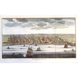
Samboupo.
Detailed view of Samboupo on the island of Celebes (Sulawesi) Indonesia. Over one dozen ships are sailing in the harbour and river. By Jacob van der Schley in 1750.
Date: Paris, 1750
Selling price: ????
Please login to see price!
Sold in 2019
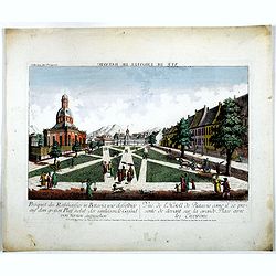
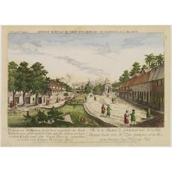
Prospect des Rathhauses in Batavia wie dasselbige auf dem grossen Platz nebst der um liegende Gegend (von fornen anzusehen).
A view of present-day Fatahillah Square in Jakarta. In the middle of the print the Raadhuis , headquarters of the VOC -nowadays the Jakarta museum-is clearly visible.
Date: Augsburg, 1750
Selling price: ????
Please login to see price!
Sold in 2016
Carte des Isles Voisines Des Moluques
An old antique cartographic map of the Molucas Isles in Indonesia, including Ceram - Bouro Amboine - Banda – Neyra, by Bellin from Abbe A.F. Prévost’s, “Histoire G...
Date: Paris, 1750
Selling price: ????
Please login to see price!
Sold in 2016
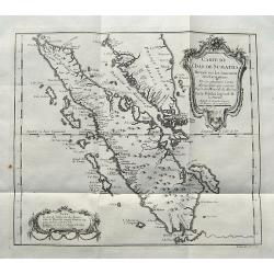
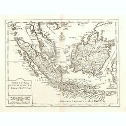
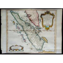
Carte de L'Isle de Sumatra...
A detailed map of Sumatra and parts of the Malay Peninsula with the Straits of Singapore. Many towns, islands, and rivers are named.Decorated with a large title cartouche...
Date: Paris, ca 1750
Selling price: ????
Please login to see price!
Sold in 2017
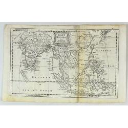
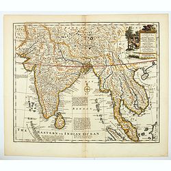
East Indies.
A fine map of the East Indies, bounded by China in the northeast, the Timors and New Guinea in the Southeast, India and the Maldives in the Southwest and Tibet and the Mo...
Date: London, ca. 1750
Selling price: ????
Please login to see price!
Sold in 2017
Carte de L'Isle Celebes ou Macassar.
A fine copper engraved map of Celebes Island. It is the provincial capital of South Sulawesi, Indonesia. It is the largest city on Sulawesi Island in terms of population ...
Date: Paris, 1750
Selling price: ????
Please login to see price!
Sold in 2018
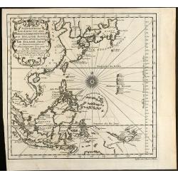
Archipel Des Indes Orientales, qui comprend Les Isles De La Sonde.. Philippines..
An attractive and detailed view of the Indonesian islands in large format and Malacca and Southern China to the Philippines, New Guinea and Northern Australia. Includes a...
Date: Paris, 1750
Selling price: ????
Please login to see price!
Sold in 2018
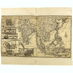
Charte von Ost-Indien und den Angraentzenden Laendern'... 'Geographi Mr. Herman Moll ... Durch M. Georg. Christian Bohnstedt Rector an der Dom-Schule zu Halberst. . .1737
Rare German map showing the area from India to Japan, and south to include the East Indies. The map is filled with information on political divisions, towns, and roads. T...
Date: Lepzig, ca. 1750
Selling price: ????
Please login to see price!
Sold in 2020
Carte de l'Isle de Sumatra....
Map of Sumatra, also showing the tip of the Malay Peninsula and the Straits of Singapore. An unusually detailed map of the area, showing many coastal features, shoals, ba...
Date: Paris, 1750
Selling price: ????
Please login to see price!
Sold in 2018
Archipel Des Indes Orientales, qui comprend Les Isles De La Sonde.. Philippines..
An attractive and detailed view of the Indonesian islands in large format. Decorative title cartouche.
Date: Paris, 1750
Selling price: ????
Please login to see price!
Sold in 2021
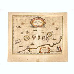
Insularum Moluccarum ..
Exquisite map of the famous Spice Islands based on the islands described by Jan Huyghen van Linschoten. This map was the first large scale map of the region and depicts t...
Date: Amsterdam, 1750
Selling price: ????
Please login to see price!
Sold in 2020
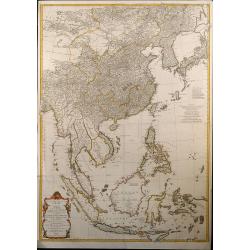
Seconde partie de la carte d'Asie contenant la Chine et partie de la Tartarie, l'Inde ... Sumatra, Java, Borneo, Moluques, Philippines et du Japon
Attractive large map of Asia from G. de la Haye by J.B.B. d'Anville. Showing southeast Asia with Japan and Korea. Printed on two plates, joined.
Date: Paris, 1752
Selling price: ????
Please login to see price!
Sold in 2009
Seconde partie de la carte d\'Asie contenant la Chine et partie de la Tratarie, l\'Inde ... Sumatra, Java, Borneo, Moluques, Philippines et du Japon
Attractive large map of Asia from G. de la Haye by J.B.B. d\'Anville. Showing south east Asia with Japan and Korea. Printed on two plates
Date: Paris, 1752
Selling price: ????
Please login to see price!
Sold in 2008
Seconde partie de la carte d'Asie contenant la Chine et partie de la Tratarie, l'Inde . . . Sumatra, Java, Borneo, Moluques, Philippines et du Japon.
An attractive large map of Asia from G. de la Haye by J.B.B. d'Anville. Showing south east Asia with Japan and Korea. Printed on two plates.
Date: Paris, 1752
Selling price: ????
Please login to see price!
Sold in 2010
