Browse Listings in Asia > South East Asia > Sumatra
![Sumatra] Iava minore / Necumera/Locaz/Patera/Botegon/Mangama.](/uploads/cache/81948-250x250.jpg)
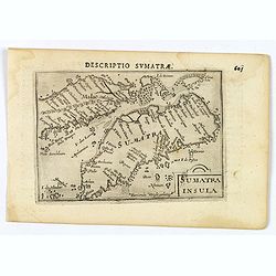
Sumatra] Iava minore / Necumera/Locaz/Patera/Botegon/Mangama.
Two maps on one page of the Isalario. 'Iava minore', the first printed separate map of Sumatra and several islands 'Necumera / Locaz / Patera / Botegon / Mangama. Locaz o...
Date: Venice, 1534
Selling price: ????
Please login to see price!
Sold in 2019
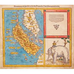
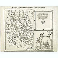
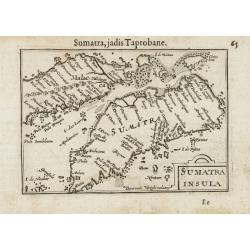
Sumatra ein grosse Insel so von den alten Geographen Taprobana genennt worden.
Sebastian Münster, 1489-1552, outstanding geographer of Basle. Edited Ptolemy's atlas Geographia Universalis, editions 1540,-42, -45, -51 and -52. Published his Cosmograp...
Date: Basel, c. 1550
Selling price: ????
Please login to see price!
Sold in 2008
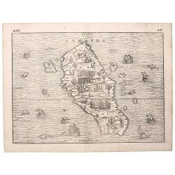
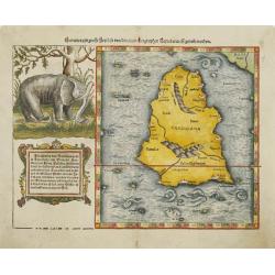
Sumatra.
A superb example of "the first separate map of any Southeast Asian island to be based on actual observation" (Suarez). It is moreover highly unusual for a map t...
Date: Venice, 1556
Selling price: ????
Please login to see price!
Sold in 2018
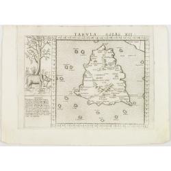
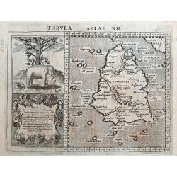
Tabula Asiae XII. . .
Uncommon first edition of one of the earliest maps of Sumatra.Girolamo Ruscelli's edition of Ptolemy's Geographia included newly engraved copperplates by Giulio and Livio...
Date: Venice, 1561
Selling price: ????
Please login to see price!
Sold in 2008
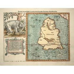
Sumatra ein grosse insel..
Map of island of Taprobana, which was variously thought to be Ceylon or Sumatra. This map depicts Ceylon with the typical misconceptions of Ptolemy showing a small part o...
Date: Basle, 1578
Selling price: ????
Please login to see price!
Sold in 2009
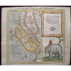
Sumatra Ein Grosse Insel / So Von Den alten Geographen Taprobana
An interesting map of Sumatra and the southern part of Malaysia. Singapore is identified at the tip of Malay peninsula as Cingafufa. Large textual cartouche which quotes ...
Date: Basle, 1580
Selling price: ????
Please login to see price!
Sold in 2011
Sumatra ein grosse Insel..
One of the most interesting fruits of the revamping of the Münster Cosmographia in 1588 was this map of the southern Malay Peninsula and Sumatra, one of the earliest to f...
Date: Basle, 1580
Selling price: ????
Please login to see price!
Sold
Sumatra ein Grosse Insel so von den Alten Geographen Taprobana Genennet Worden.
Early, desirable map of the island of Sumatra and the southern part of Malaysia. It is one of the earliest maps to focus on this region. Shown near today's Singapore on t...
Date: Basle, S.H. Petrie, 1588
Selling price: ????
Please login to see price!
Sold in 2014
Sumatra Insula - Taproba.
On recto a wood block printed map of Sumatra within text bearing the name "Taprobana". The island is filled with many images like an elephant and a tiger, as we...
Date: Basle, 1550-1590
Selling price: ????
Please login to see price!
Sold in 2013
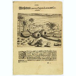
Illustrations of Lancuas, Fagaras, Lacca and Cuci fructa.
Common in Bali, Java and Sunda is a plant known as the great Galanga or Galigam. The natives, however, call it Lancuas. The fagaras, particularly found in Sunda, looks li...
Date: Frankfurt, 1598
Selling price: ????
Please login to see price!
Sold in 2026
Sumatra Insula.
This lovely miniature map shows the S.E. Asian Islands of Sumatra and (part) Malaysia, published by Petrus Bertius, in Amsterdam at the beginning of the seventeenth centu...
Date: Amsterdam, 1606
Selling price: ????
Please login to see price!
Sold in 2020
Sumatra.
A miniature map of Sumatra containing detailed geography and nomenclature around the entire island. The neighboring coast of the Malay Peninsula is shown, including Singa...
Date: Amsterdam / Frankfurt, 1609
Selling price: ????
Please login to see price!
Sold in 2014
Tabula Asiae XII (Sri Lanka or Sumatra).
A fine Ptolemaic map of the Island of "Taprobana". Some sources say although this map is titled Taprobana (Sri Lanka or Ceylon), it is actually the island of Su...
Date: Amsterdam, 1617
Selling price: ????
Please login to see price!
Sold in 2018
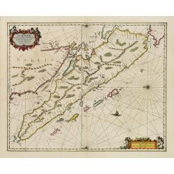
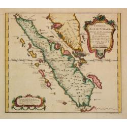
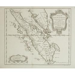
Sumatrae et insularum Locorumque nonnullorum circumiacentium..
Fine chart depicting the Island of Sumatra and the southern coasts of Malaysia from Quedo to Johore.North is orientated to the left of the page.Singapore is probably iden...
Date: Amsterdam 1660
Selling price: ????
Please login to see price!
Sold
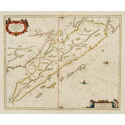
Sumatrae et insularum Locorumque nonnullorum circumiacentium
Fine chart depicting the Island of Sumatra and the southern coasts of Malaysia from Quedo to Johore. North is orientated to the left of the page. Singapore is probably id...
Date: Amsterdam 1660
Selling price: ????
Please login to see price!
Sold
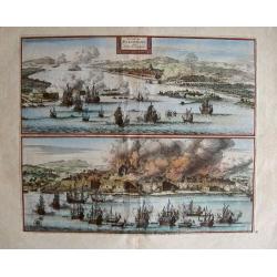
La Ville de Palimbang dans L'Ile de Sumatra.
A very decorative, impressive old-colored engraving of Palembang in Sumatra. Two views on one sheet. In the upper part the overall view with a sea battle in the foregroun...
Date: Leiden, 1706
Selling price: ????
Please login to see price!
Sold in 2014
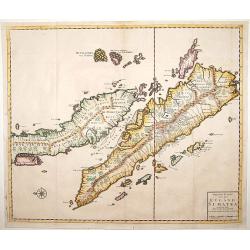
Nieuwe Kaart van het Eyland Sumatra..
Fine chart depicting the Island of Sumatra and the southern coasts of Malaysia from Quedo to Johore. North is orientated to the left of the page. Singapore is probably id...
Date: Amsterdam 1724
Selling price: ????
Please login to see price!
Sold
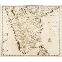
Nieuwe Kaart van Choromandel ende Malabar..
"Fine chart depicting the southern part of India and the northern tip of Ceylon. Much detail is given along the coastlines, settlements and principal coastal feature...
Date: Amsterdam 1724
Selling price: ????
Please login to see price!
Sold
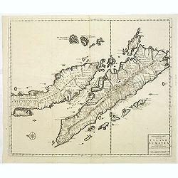
Nieuwe Kaart van het Eyland Sumatra..
Fine chart depicting the Island of Sumatra and the southern coasts of Malaysia from Quedo to Johore. North is orientated to the left of the page. Singapore is probably id...
Date: Amsterdam 1724
Selling price: ????
Please login to see price!
Sold
Nieuwe Kaart van het Eyland Sumatra..
Fine chart depicting the Island of Sumatra and the southern coasts of Malaysia from Quedo to Johore. North is orientated to the left of the page. Singapore is probably id...
Date: Amsterdam, 1726
Selling price: ????
Please login to see price!
Sold in 2011
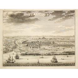
Atsjien.
From Francois Valentyn's Oud en Nieuw Oost Indien, part V : Beschryving van Coromandel, Pegu, Arrakan, Bengale, Mocha, Persien, Malakka, Sumatra, Ceylon.A bird's eye-view...
Date: Amsterdam, 1728
Selling price: ????
Please login to see price!
Sold
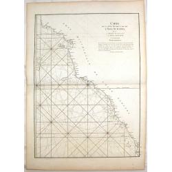
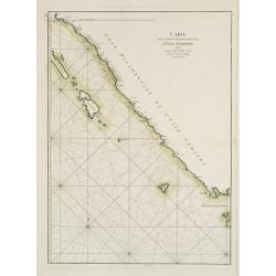
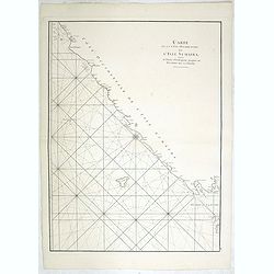
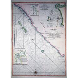
Carte de la Cote Occidentale de L'isle Sumatra.
Coastal Map of West Sumatra, an island in Western Indonesia. It is from Le Neptune Oriental. Jean-Baptiste d'Après de Mannevillette (1707-1780) was a French sailor, navi...
Date: Paris, 1745
Selling price: ????
Please login to see price!
Sold in 2018
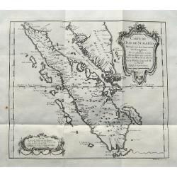
Carte de L'Isle de Sumatra...
A detailed map of Sumatra and parts of the Malay Peninsula with the Straits of Singapore. Many towns, islands, and rivers are named.Decorated with a large title cartouche...
Date: Paris, ca 1750
Selling price: ????
Please login to see price!
Sold in 2017
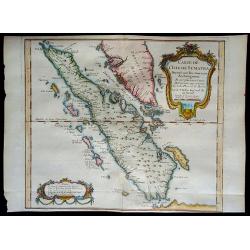
Carte de l'Isle de Sumatra....
Map of Sumatra, also showing the tip of the Malay Peninsula and the Straits of Singapore. An unusually detailed map of the area, showing many coastal features, shoals, ba...
Date: Paris, 1750
Selling price: ????
Please login to see price!
Sold in 2018
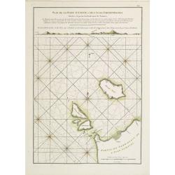
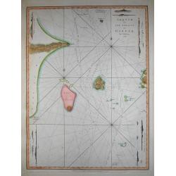
Vlakke hoek van Sumatra.
Showing the part of the west coast of Sumatra with the island of Enggano. Very rare: included in 6th volume, so-called secret atlas of the V.O.C. of Van Keulen. Latitude ...
Date: Amsterdam 1753
Selling price: ????
Please login to see price!
Sold
Carte d L' Isle de Sumatra.
Jaques Nicolas Bellin (1702-720) was the most important French hydrographer of the 18th century. Sea-atlas 'Hydrographique Français' , 1756-65, atlas to accompany Prévost...
Date: Paris, c. 1755
Selling price: ????
Please login to see price!
Sold in 2008
Carte de l'Isle de Sumatra Dréssée sur les Journaux des Navigateurs...
Map of Sumatra, also showing the tip of the Malay Peninsula and the Straits of Singapore. An unusually detailed map of the area, showing many coastal features, shoals, ba...
Date: Paris, 1758
Selling price: ????
Please login to see price!
Sold in 2008
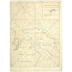
The straits of Banca. . .
Uncommon English with the Straits of Banca in northern part of Sumatra, with inset map in top right corner.William Herbert (1718-1795), was born 29 Nov. 1718, and was ed...
Date: London, 1767
Selling price: ????
Please login to see price!
Sold in 2011
A particular plan of Acheen road with the islands adjacent. . .
Uncommon English of part of the most northern part of Sumatra, with the ancient Sultanate of Acheen.William Herbert (1718-1795), was born 29 Nov. 1718, and was educated ...
Date: London, 1767
Selling price: ????
Please login to see price!
Sold in 2011
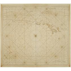
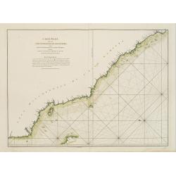
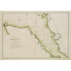
Carte de la Côte occidentale de l'Isle de Sumatra. . .
French of the lower west coast of Sumatra. Latitude and longitude scales, compass rose and system of rhumb lines, soundings near coast and in bay areas.D' Après de Manne...
Date: Paris, ca 1775
Selling price: ????
Please login to see price!
Sold
Carte Plate de la Côte Occidentale de l'Isle de Sumatra?
French chart of the north west coast of the island of Sumatra.Latitude and longitude scales, compass rose and system of rhumb lines, soundings near coast and in bay areas...
Date: Paris, ca 1775
Selling price: ????
Please login to see price!
Sold
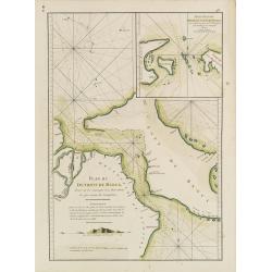
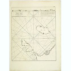
Plan du Détroit de Banca.. / Petit plan du Détroit à l'Est de Banca.
French detailed of the straits between Sumatra and Bangka. With inset : Petit plan du Détroit à l'Est de Banca.. The chart is an updated version of an earlier copper pla...
Date: Paris, ca 1775
Selling price: ????
Please login to see price!
Sold in 2019
Carte de la Côte occidentale de l\'Isle de Sumatra. . .
French of the lower west coast of Sumatra. Latitude and longitude scales, compass rose and system of rhumb lines, soundings near coast and in bay areas.D' Après de Manne...
Date: Paris, Brest, chez Demonville, 1775
Selling price: ????
Please login to see price!
Sold in 2014
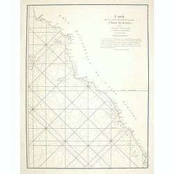
Carte de la côte occidentale de l\'isle Sumatra depuis la ligne équinoctiale jusqu\'au détroit de la Sonde
French of the east coast of Sumatra.Latitude and longitude scales, compass rose and system of rhumb lines, soundings near coast and in bay areas.D' Après de Mannevillett...
Date: Paris, Brest, chez Demonville, 1775
Selling price: ????
Please login to see price!
Sold in 2014
Carte Plate de la partie Septentrionale du Détroit de Malac depuis la Rade d'Achem jusqu'à Malac.
French of the Island of Sumatra and the Malay Peninsula separated by the strait of Malacca in Indonesia. Latitude and longitude scales, compass rose and system of rhumb ...
Date: Paris, ca 1775
Selling price: ????
Please login to see price!
Sold
Plan de la Rade d'Achem et des Isles Circonvoisines Situées à la partie Nord-ouest de Sumatra.
French large nautical of the Archem coast on the northwestern point of Sumatra.Latitude and longitude scales, compass rose and system of rhumb lines, soundings near coas...
Date: Paris, Brest, chez Demonville, 1775
Selling price: ????
Please login to see price!
Sold in 2019
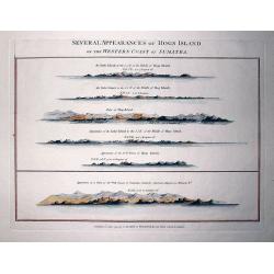
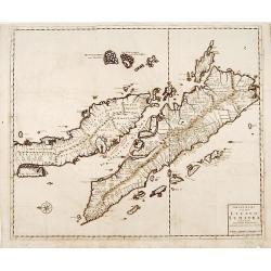
Several Appearances of Hogs Island on the Western Coast of Sumatra.
RARE sheet from "The country East-India Pilot" published in 1799 by Laurie & Whittle. Interesting copper engraved sheet with five views of Hogs Island and ...
Date: London, 1794
Selling price: ????
Please login to see price!
Sold in 2011
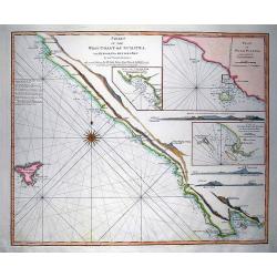
Chart of the West Coast of Sumatra, from Bencoolen to Key Sers Bay.
RARE nautical from "The country East-India Pilot" published in 1799 by Laurie & Whittle. Superb copper engraved map Western Sumatra with Isle Engano or De...
Date: London, 1794
Selling price: ????
Please login to see price!
Sold in 2011
Sketch of the Straits of Gaspar...
SCARCE nautical after J. Huddart 1788, published in "The country East-India Pilot" in 1799 by Laurie & Whittle. Great copper engraved map the Strait of Ga...
Date: London, 1794
Selling price: ????
Please login to see price!
Sold in 2011
A New Chart of the West Coast of Sumatra,...
SCARCE nautical from "The country East-India Pilot" published in 1799 by Laurie & Whittle. Great copper engraved map of Western Sumatra and Nassau or Pogg...
Date: London, 1794
Selling price: ????
Please login to see price!
Sold in 2011
![[View of the town of Padang].](/uploads/cache/25838-250x250.jpg)
[View of the town of Padang].
Aquatint depicting a view of Padang, a Dutch Fortress in Sumatra, engraved G.Castellini. Plate N° 47. Sumatra (also spelled Sumatera) is the sixth largest island in the w...
Date: Milan, 1827
Selling price: ????
Please login to see price!
Sold in 2008
![[Maisons à Sumatra]](/uploads/cache/25839-250x250.jpg)
[Maisons à Sumatra]
Aquatint depicting a lively scene in a Sumatra village, engraved by Castellini. Plate N° 48 From Giulio Ferrario's work Le Costume Ancien et Moderne ou Histoire du gouver...
Date: Milan, 1827
Selling price: ????
Please login to see price!
Sold in 2017
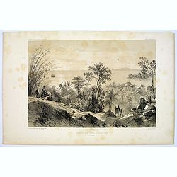
Mouillage dans la Baie de Rajah Bassa.
A tranquil lithograph of the anchorage in the Bay of Rajah Bassa on the Indonesian island of Sumatra. Plate 151 taken from the 'Voyage au Pole et dans L'Oceanie…' Departi...
Date: Paris, 1842
Selling price: ????
Please login to see price!
Sold in 2016
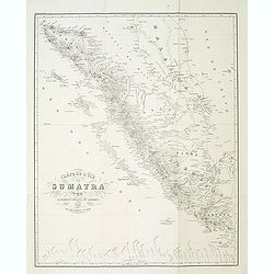
Carte de l'ile de Sumatra par le baron P.Melvill de Carnbee 1848. . .
Detailed map of Sumatra and the southern tip of Malacca with Singapore. Prepared in 1848 by baron P.Melvill de Carnbee and engraved by D.Heyse. From the rare work "L...
Date: The Hague, Belifante freres, 1848
Selling price: ????
Please login to see price!
Sold in 2013
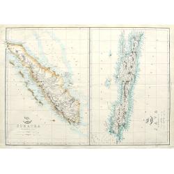
Sumatra; Java;
Two maps on one sheet. Both maps are highly detailed, filled with place names. The Sumatra map shows also Malaysia and Singapore. "The Weekly Dispatch" newspa...
Date: London, ca. 1860
Selling price: ????
Please login to see price!
Sold in 2018
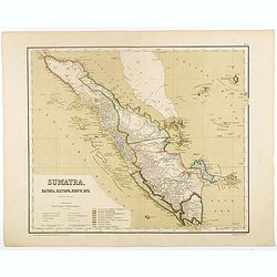
Sumatra, Bangka, Blitong, Riouw, enz. (with Singapore)
Very detailed map of Sumatra, with Singapore to the East, taken from "Atlas van Nederlandsch Oost- en West-Indie", prepared by doctor I. Dornseiffen, and publis...
Date: Amsterdam, Seyffardt, 1884
Selling price: ????
Please login to see price!
Sold in 2017
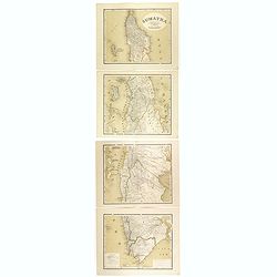
Sumatra op een schaal van 1: 1450000
Very detailed map of Sumatra on 4 sheets, taken from "Atlas van Nederlandsch Oost- en West-Indie", prepared by doctor I. Dornseiffen, and published by published...
Date: Amsterdam, Seyffardt, 1884
Selling price: ????
Please login to see price!
Sold in 2017
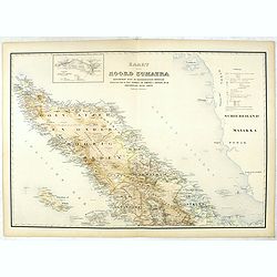
Kaart van Noord Sumatra: Gouvernement Atjeh en Onderhoorigheeden / Noordelijke gedeelten van de Res.n Tapanoeli en Sumatra's Oostkust / en de onafhankelijkeBatak Landen. . .
Very detailed map of Northen Sumatra, taken from "Atlas der Nederlandsche bezittingen in Oost-Indië", who was published by Departement van Koloniën".First ...
Date: The Hague, 1883-1885
Selling price: ????
Please login to see price!
Sold in 2023
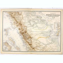
Kaart van Midden-Sumatra : Gouver.nt v. Sumatra's Westkust, Zuid ged. d. R. Sumatra's-Oostkust, Afd. Lingga v.d. Res. Riouw en Onderh. en het Rijk Djambi.
Very detailed map of Central Sumatra, taken from "Atlas der Nederlandsche bezittingen in Oost-Indië", who was published by Departement van Koloniën". With ...
Date: The Hague, 1883-1885
Selling price: ????
Please login to see price!
Sold in 2017
