Browse Listings in Asia > South East Asia
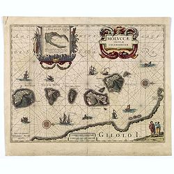
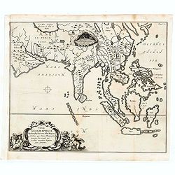
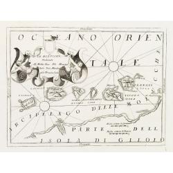
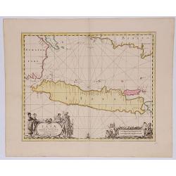
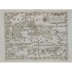
MOLUCCAE Insulae Celeberrimae.
A highly decorative map of the "Spice Islands".
Date: Amsterdam, ca. 1660
Selling price: ????
Please login to see price!
Sold in 2018
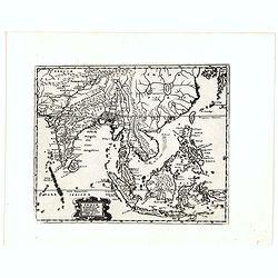
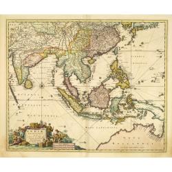
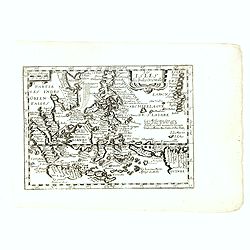
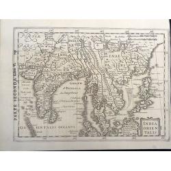
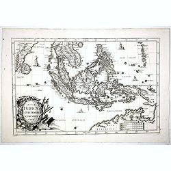
Indiae Orientalis et Insularum Antiqua et nova Descriptio.
Interesting map of South East Asia, including Indonesia, India, Taiwan from a German edition of Philipp Clüver's famous Introductionis in Universam geographicam, first p...
Date: Wolfenbüttel, 1661
Selling price: ????
Please login to see price!
Sold in 2009
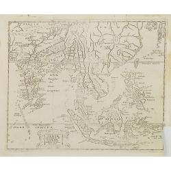
Indiae Orientalis et Insularum Antiqua et nova Descriptio.
Interesting map of South East Asia, including Indonesia, India, Taiwan, Philippines from Philipp Clüver's famous Introductionis in Universam geographicam, first publishe...
Date: Wolfenbüttel, 1661
Selling price: ????
Please login to see price!
Sold in 2020
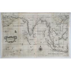
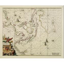
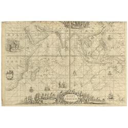
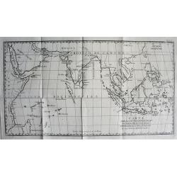
Carta prima Generale dell' Asia.
A rare sea chart of India and Indonesia, in a first state. The chart appeared in Dudley's Arcano del Mare, one of the rarest and most highly sought after sea atlases of t...
Date: Florence, 1641/1661
Selling price: ????
Please login to see price!
Sold in 2019
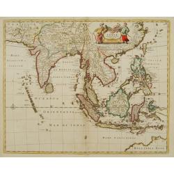
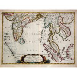
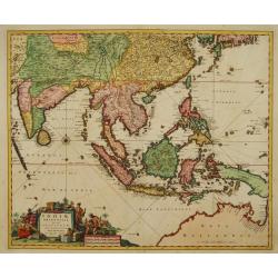
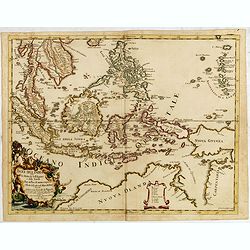
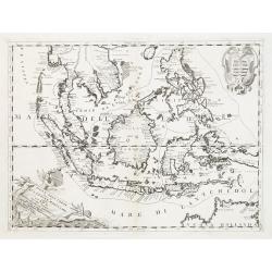
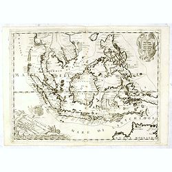
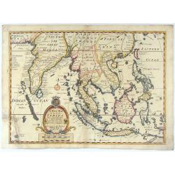
Tabula Indiae Orientalis.
An attractive and decorative map covering all South East Asia engraved by Johannes Lhuilier. The map encompasses the region from India to Southern China, Taiwan and the P...
Date: Amsterdam, 1662
Selling price: ????
Please login to see price!
Sold in 2011
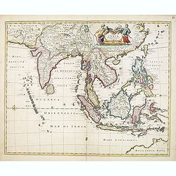
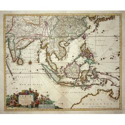
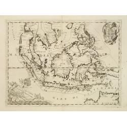
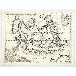
Tabula Indiae Orientalis.
An attractive and decorative map covering all South East Asia engraved by Johannes Lhuilier. The map encompasses the region from India to Southern China, Taiwan and the P...
Date: Amsterdam, 1662
Selling price: ????
Please login to see price!
Sold in 2015
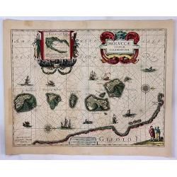
Moluccae Insulae Celeberrimae.
A striking map of the famous Spice Islands, originally described by Van Linschoten. This map was the first large-scale map of the region and depicts the islands that prov...
Date: Amsterdam, 1662
Selling price: ????
Please login to see price!
Sold in 2017
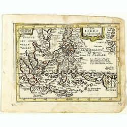
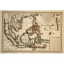
Les Isles des Indes Orientales. (23).
Scarce map of Indonesia and the Philippines published by Antoine de Fer in 1661 or 1662 in "Cartes de géographie revues et augmentées". With number 23 in lowe...
Date: Paris, Antoine de Fer, 1657 but 1661 or 1662
Selling price: ????
Please login to see price!
Sold in 2018
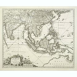
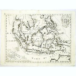
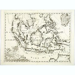
Tabula Indiae Orientalis.
An attractive and decorative map covering all South East Asia engraved by Johannes Lhuilier. The map encompasses the region from India to Southern China, Taiwan and the P...
Date: Amsterdam, 1662
Selling price: ????
Please login to see price!
Sold in 2020
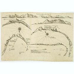
(6 coastal profiles)
A page with 6 coastal profiles of favorite anchor places and bays used by the Dutch and French vessels on their way to Asia : "Figure de la Terre de Saldagne",...
Date: Paris, 1663
Selling price: ????
Please login to see price!
Sold in 2011
![[Map covering the area from India till Australia.]](/uploads/cache/36448-250x250.jpg)
[Map covering the area from India till Australia.]
Probably of Portuguese origin, this appeared in Thevenot's Relations de divers Voyages , the greatest collection of travel accounts of the seventeenth century. Of partic...
Date: Paris, Langlois, 1663
Selling price: ????
Please login to see price!
Sold in 2015
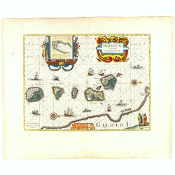
Moluccae Insulae Celeberrimae.
Showing the geographical features of the spice islands, and decorated with ships, sea monsters and a handsome cartouche. In addition to a sumptuous title cartouche, the m...
Date: Amsterdam, 1663
Selling price: ????
Please login to see price!
Sold in 2016
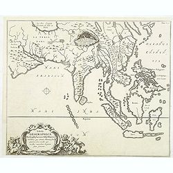
Tabula Geographica Hydrophylacium Asiae Majoris. . .
The Jesuit scholar Athanasius Kircher was one of the first compilers of semi-scientific knowledge about the physical features of the world. This very unusual map depicts ...
Date: Amsterdam, 1665
Selling price: ????
Please login to see price!
Sold in 2011
Tabula Geographica Hydrophylacium Asiae Majoris exhibens, quo Omnia Flumina sive proxime sive remote per occultos maeandros Originem suam Sortiuntur.
Rare and Interesting map showing Asia from Arabia in the west until China, Japan, Korea and Philippines with Indonesia. From Kircher's "Mundus Subterranaeus". T...
Date: Amsterdam, 1665
Selling price: ????
Please login to see price!
Sold in 2020
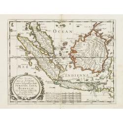
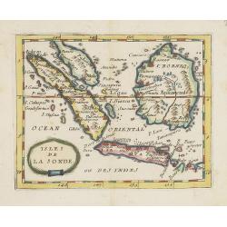
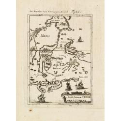
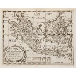
Les Isles de la Sonde entre lelquelles font Sumatra, Iava, Borneo. . .
Map of the islands of Java, Sumatra, Borneo and Bali. prepared by N.Sanson and published by Pierre Mariette.Published in an early edition of the small Sanson atlas L'Euro...
Date: Paris, P. Mariette, 1667
Selling price: ????
Please login to see price!
Sold in 2013
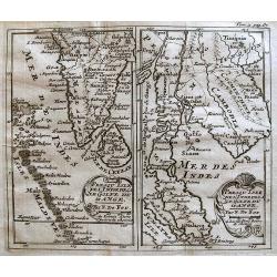
Partie meridionale de l'' Inde En deux Presqu'' Isles l'' une deçà et l'' autre delà Gange. 1654.
Nicolas Sanson?s map of southern Asia with the Indian subcontinent, Indochina, Malaysia, Sumatra and western Borneo.Nicolas Sanson (1600-67), "father of the French c...
Date: Paris, 1658-1670
Selling price: ????
Please login to see price!
Sold in 2016
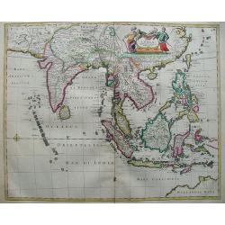
Tabula Indiae Orientalis.
The map shows from southeastern Persia to northwestern Australia. Focus is on India, Southeast Asia, and the East Indies with the Philippines. The many islands are clearl...
Date: Amsterdam, 1670
Selling price: ????
Please login to see price!
Sold in 2012
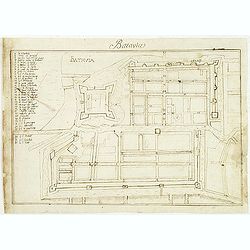
Batavia.
Manuscript town-plan of Batavia, nowadays Jakarta, as it was at about 1639, by which time the part of the town on the western bank of the Ciliwung had already been laid o...
Date: France, 1650- 1670
Selling price: ????
Please login to see price!
Sold in 2011
Isles de la Sonde.
Uncommon miniature map of the Indonesian islands (Java, Sumatra and Borneo) from Pierre Duval's La Geographie Universeille dated 1676. With "Sincapura" and &quo...
Date: Paris, 1672
Selling price: ????
Please login to see price!
Sold in 2022
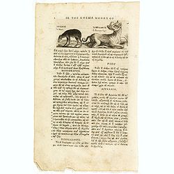
Le Musc. le Pourceau-cerf.
An early text engraving of a musk-deer and a babirusas, also called pig-deer published from 1672 onwards in "Relations de Divers Voyages Curieux" by the French ...
Date: Paris, 1672
Selling price: ????
Please login to see price!
Sold in 2015
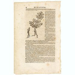
(Wood cut f a ginseng plant)
An early wood block engraving of a ginseng plant with a description by Thévenot citing Martini's explanation that "ginseng" was derived from ren (person). From...
Date: Paris, 1672
Selling price: ????
Please login to see price!
Sold in 2015
![Orientaliora Indiarum Orientalium cum Insulis Adjacentibus a Promontorio C. Comorin ad Iapan. [together with] Occidentalior Tractus Indiarum Orientalium.](/uploads/cache/33091-250x250.jpg)
Orientaliora Indiarum Orientalium cum Insulis Adjacentibus a Promontorio C. Comorin ad Iapan. [together with] Occidentalior Tractus Indiarum Orientalium.
A matching set of two splendid sea charts covering the trading area of the Dutch V.O.C. and lavishly colored and hightened with gold by the Orientaliora Indiarum Oriental...
Date: Amsterdam, 1675
Selling price: ????
Please login to see price!
Sold
Indiae Orientalis nec non Insularum adiacentium.
Decorative map extending from India in the west, southern Japan in the north and the north coast of Australia is shown at bottom right with some coastal names till Cape Y...
Date: Amsterdam 1680
Selling price: ????
Please login to see price!
Sold
Indiae Orientalis nec non Insularum Adiacentium Nova Descriptio.
This superb map of South East Asia presents a detailed image of the sphere of operations and Asian trading empire of the Dutch East India Company. The map extends from In...
Date: Amsterdam, 1680
Selling price: ????
Please login to see price!
Sold
Orientaliora Indiarum Orientalium cum Insulis Adjecentibus.
Oriental figures in title piece bottom left. Orientated with East at the top of the map.A splendid sea chart of the Southeast Asia illustrating the Dutch sphere of influe...
Date: Amsterdam, 1675-1680
Selling price: ????
Please login to see price!
Sold
Indiae Orientalis nec non Insularum adiacentium.
Decorative map extending from India in the west, southern Japan in the north and the north coast of Australia is shown at bottom right with some coastal names till Cape Y...
Date: Amsterdam, 1680
Selling price: ????
Please login to see price!
Sold in 2011
Indiae orientalis, nec non Insularum Adiacentium . . .
The north coast of Australia is shown at bottom right with some coastal names.
Date: Amsterdam, 1680
Selling price: ????
Please login to see price!
Sold in 2015
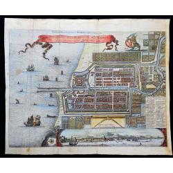
Plan de la Ville…de Batavia / Ware afbeeldinge wegens het Casteel ende Stadt Batavia gelegen opt groot Eylant Java
Very interesting map of Batavia (modern-day Jakarta) as key base in Asia for the Dutch East-Indies Company (VOC). The map shows the city and the surrounding area and is ...
Date: 1680
Selling price: ????
Please login to see price!
Sold in 2021
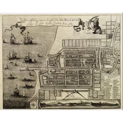
Waere affbeeldinge wegens het casteel ende stadt Batavia.
A good impression of this finely engraved and detailed plan of Batavia, present-day Jakarta, the Dutch V.O.C. center of trading activities in the East Indies. Copied afte...
Date: Amsterdam, 1681
Selling price: ????
Please login to see price!
Sold in 2011
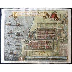
Waere affbeeldinge wegens het casteel ende stadt Batavia.
A large, detailed and finely engraved plan of Batavia, present-day Jakarta, the Dutch center of trading activities in the East Indies. Magnificently engraved by Matheus d...
Date: Amsterdam, 1681
Selling price: ????
Please login to see price!
Sold in 2019
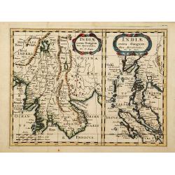
Indiae extra Gangem pars Septentrio../ ..pars Meridionalis..
Showing to the left Burma, Thailand, Cambodia etc. The map to the right shows the Malaysian peninsula, Singapore and northern Sumatra.
Date: Utrecht 1683
Selling price: ????
Please login to see price!
Sold
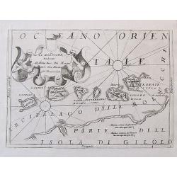
Isles dela Sonde vers l'Orient.
A late 17th century miniature map of the Moluccas and southern part of the Philippines, by Allain Manneson Mallet (1630-1706), a well traveled military engineer and geogr...
Date: Paris, 1683
Selling price: ????
Please login to see price!
Sold in 2013
![Isole dell 'India cioè le Molucche le Filippine e della Sonda . . . [East Indies].](/uploads/cache/26611-250x250.jpg)
Isole dell 'India cioè le Molucche le Filippine e della Sonda . . . [East Indies].
In lower left hand corner a large title cartouche, decorated with mermaids, mermen and playful putti. A scarce, uncommon, late 17th century map of South East Asia, based ...
Date: Rome, 1683
Selling price: ????
Please login to see price!
Sold in 2008
![Isole dell 'India cioè le Molucche le Filippine e della Sonda . . . [East Indies].](/uploads/cache/31192-250x250.jpg)
Isole dell 'India cioè le Molucche le Filippine e della Sonda . . . [East Indies].
In lower left hand corner a large title cartouche, decorated with mermaids, mermen and playful putti. A scarce, uncommon, late 17th century map of South East Asia, based ...
Date: Rome, 1683
Selling price: ????
Please login to see price!
Sold in 2011
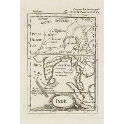
Inde.
A charming late 17th century French map of India, Malay Peninsular with a decorative title cartouche.By Allain Manneson Mallet (1630-1706), a well traveled military engin...
Date: Frankfurt, 1684
Selling price: ????
Please login to see price!
Sold in 2008
![Isle de la Sonde vers L\'Orient. [Moluccan Islands]](/uploads/cache/26298-250x250.jpg)
Isle de la Sonde vers L\'Orient. [Moluccan Islands]
A charming late 17th century map of the Moluccas Islands. By Allain Manneson Mallet (1630-1706), a well traveled military engineer and geographer who worked in 17th centu...
Date: Frankfurt, 1684
Selling price: ????
Please login to see price!
Sold in 2008
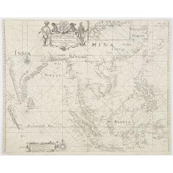
A chart of the trading part of the East Indies and China with the adjaccent islands of Surrat to Japan. . .
In upper part a fine title cartouche with the names of John Thornton, John Seller, William Fisher, James Atkinson and John Colton. With inset map (63x136mm) of Japan. Cov...
Date: London, 1685
Selling price: ????
Please login to see price!
Sold in 2010
Les Isles des Indes Orientalle.
Rare map of Indonesia, with an oversized Philippines, published by François Jollain (ca. 1641 – 18 April 1704) and included in "Trésor Des Cartes Geographiques D...
Date: Paris, 1687
Selling price: ????
Please login to see price!
Sold in 2018
Isole dell' India cioe la molucche Le Filippine...
Giacomo Rossi's fine late 17th century map of South East Asia, with nice detail on Philippines. Issued in Il Mercurio geografico In lower left corner a tittle cartouche. ...
Date: Rome, 1683-1688
Selling price: ????
Please login to see price!
Sold in 2017

Isole dell' India cioe la molucche Le Filippine...
Giacomo Rossi's fine late 17th century map of South East Asia. Issued in Il Mercurio geografico In lower left corner a tittle cartouche. The cartographer was Giacomo Cant...
Date: Rome, 1683-1688
Selling price: ????
Please login to see price!
Sold in 2015
Le Molucche..
Map of the Moluccas Islands with decorative title cartouche. West to the top. By the remarkable Vincenzo Coronelli, (1650-1718), a Franciscan Friar and appointed General ...
Date: Venice 1690
Selling price: ????
Please login to see price!
Sold
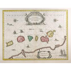
Insularum Moluccarum Nova descriptio.
The small spice islands off the west coast of the island of Halmahera in the eastern part of the archipelago. With an imposing title cartouche, together with finely drawn...
Date: Amsterdam, 1690
Selling price: ????
Please login to see price!
Sold in 2012
OOST INDIEN Wassende-Graade Paskaart, vertoonende nevens het Oosterlykste van Afrika, meede de Zeekusten van Asia, van C. de Bona Esperance tot Eso, boven Japan. . .
(Sea chart of the East Indies on Mercator projection delineating not only the eastern coast of Africa, but also the coasts of Asia, from the C. of Good Hope till Eso, nor...
Date: Amsterdam, ca.1690
Selling price: ????
Please login to see price!
Sold in 2010
Insulae Iavae Cum parte insularum Borneo Sumatrae.
A beautiful map of Java and parts of the islands Borneo, Sumatra and Bali. Only the coast is indicated in detail with Batavia (Jakarta) top left .The map is enhanced with...
Date: Amsterdam, 1690
Selling price: ????
Please login to see price!
Sold in 2017
Le Molucche, Dedicate al Molto Rev: Pre Maestro Carlo Tosi, Min Congio Provinceale.
An uncommon engraved map of the Maluku or Moluccas Islands in Indonesia. In the past the islands were also known as the 'Spice Islands'. The islands are shown with their ...
Date: Venice, ca. 1690
Selling price: ????
Please login to see price!
Sold in 2017
India Orientalis.
This is a very rare map and a reduced version of Jodocus Hondius' folio map of South East Asia. It covers the region from India through southern China and the Philippines...
Date: Amsterdam, 1690
Selling price: ????
Please login to see price!
Sold in 2020
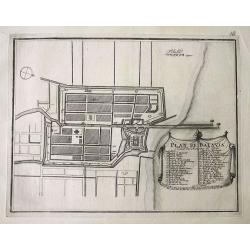
Plan de Batavia.
Plan of Jakarta, the former Dutch colonial capital in Indonesia. The title and key cartouche identifies 41 locations.
Date: Paris, 1696
Selling price: ????
Please login to see price!
Sold in 2016

Isole dell'Indie. . .
A beautiful and flamboyantly engraved large-scale map of the East Indies, including the Malay Peninsula, Cambodia, the Philippines and all of Indonesia and the Spice Isla...
Date: Venice, 1696
Isole dell'Indie
A beautiful and flamboyantly engraved large-scale map of the East Indies, including the Malay Peninsula, Cambodia, the Philippines and all of Indonesia and the Spice Isla...
Date: Venice 1698
Selling price: ????
Please login to see price!
Sold
Isole dell'Indie.
A beautiful and flamboyantly engraved large-scale map of the East Indies, including the Malay Peninsula, Cambodia, the Philippines and all of Indonesia and the Spice Isla...
Date: Venice, 1698
Selling price: ????
Please login to see price!
Sold in 2010
Isole Dell' Indie, diuise in Filippine, Molucche, e della Sonda . . .
A beautiful and flamboyantly engraved large-scale map of the East Indies, including the Malay Peninsula, Cambodia, the Philippines and all of Indonesia and the Spice Isla...
Date: Venice, 1698
Selling price: ????
Please login to see price!
Sold in 2012
Isole Dell' Indie, diuise in Filippine, Molucche, e della Sonda . . .
A beautiful and flamboyantly engraved large-scale map of the East Indies, including the Malay Peninsula, Cambodia, the Philippines and all of Indonesia and the Spice Isla...
Date: Venice, 1698
Selling price: ????
Please login to see price!
Sold in 2016
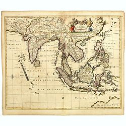
Tab. XI. Asiae, Comprehendens Indiam Extra Gangem.
This wonderful map illustrates the Ptolemaic concept of Malaya and Indochina, labeled 'India Extra Gangem' or 'India beyond the Ganges'. The map shows an oddly shaped Mal...
Date: Utrecht, 1698
Selling price: ????
Please login to see price!
Sold in 2017
Isole Dell' Indie, diuise in Filippine, Molucche, e della Sonda . . .
A beautiful and flamboyantly engraved large-scale map of the East Indies.
Date: Venice, 1698
Selling price: ????
Please login to see price!
Sold in 2018
Isole Dell' Indie, diuise in Filippine, Molucche, e della Sonda . . .
A beautiful and flamboyantly engraved large-scale map of the East Indies, including the Malay Peninsula, Cambodia, the Philippines and all of Indonesia and the Spice Isla...
Date: Venice, 1698
Selling price: ????
Please login to see price!
Sold in 2018
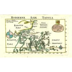
Hodiernae Asiae Tabula.
A boldly engraved map of the East Indies with large compass card and cartouche with a dedication to John Trelawney. The area north of Korea till Nova Zembla left blank an...
Date: London 1700
Selling price: ????
Please login to see price!
Sold
Les Isles de la Sonde entre lesquelles sont Sumatra, Java ?
The title is within a decorative cartouche flanked by swags of fruit. The islands of Sumatra, Java and Borneo in full, together with part of those adjacent and includes t...
Date: Amsterdam, 1700
Selling price: ????
Please login to see price!
Sold in 2010
Les Isles Molucques, Celebes, Gilolo, &c. ?
Shows the islands east of Borneo, up to and including New Guinea. From a pocket-atlas published by F. Halma.
Date: Amsterdam, 1700
Selling price: ????
Please login to see price!
Sold in 2009
CARTA PARA LA INTELIGENCIA DE LOS ESTABLECIMIENTOS DE LOS PORTUGUESES Y HOLANDESES EN LAS INDIAS ORIENTALES.
SCARCE map of the Indian Ocean and South East Asia. Extends from the East African Coast, Madagascar, and Arabia to Formosa (Taiwan), the Philippines, and New Guinea. Fa...
Date: ca. 1700
Selling price: ????
Please login to see price!
Sold in 2010
Insulae Indicae cum terris circumvicinis..
An attractive map of South-East Asia published in the uncommon Atlas Novus by the German Jesuit scholar, Heinrich Scherer. The map extends from Ceylon to the north coast ...
Date: Munich, 1700
Selling price: ????
Please login to see price!
Sold in 2017
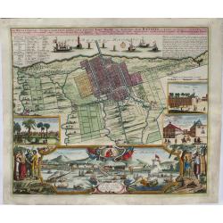
Der Hollaendisch-Ostindianischen Compagnie Weltberühmte Haupt-Handels und Niederlags-Stadt Batavia.
A truly beautiful map of Batavia, with a map of the city, two views of the city, a magnificent view of the harbor and a fine representation of the most important build...
Date: Neurenberg, 1701
Selling price: ????
Please login to see price!
Sold in 2021
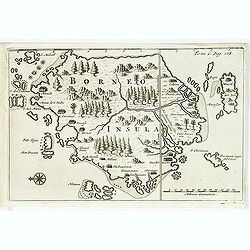
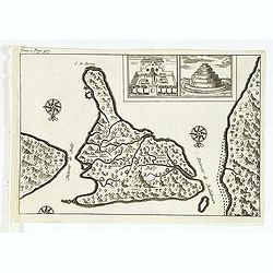
Borneo.
From a travel book deScribing the early Dutch voyages by René Augustin Constantin de Renneville Recueil des voiages qui ont servi à l'établissement & aux progrès ...
Date: Amsterdam, E. Rogers, 1702
Selling price: ????
Please login to see price!
Sold in 2012
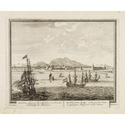
Batavia, gelegen op het eiland Java een beroemde volkplanting der Batavieren.
Town-view of Batavia (now-a-days Jakarta) seen from the harbor. On the foreground many large Dutch V.O.C. vessels.From Schenk's "Hecatompolis sive Totius Terrarum Op...
Date: Amsterdam, 1702
Selling price: ????
Please login to see price!
Sold in 2009
Batavia, gelegen op het eiland Java een beroemde volkplanting der Batavieren.
of Batavia (now-a-days Jakarta) seen from the harbor. On the foreground many large Dutch V.O.C. vessels.From Schenk's "Hecatompolis sive Totius Terrarum Oppida Nobi...
Date: Amsterdam, 1702
Selling price: ????
Please login to see price!
Sold
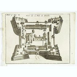
Fort de l'Isle de Banda.
Decorative print of the Dutch fortress on the island Banda.From a travel book deScribing the early Dutch voyages by René Augustin Constantin de Renneville Recueil des vo...
Date: Amsterdam, E. Rogers, 1702
Selling price: ????
Please login to see price!
Sold in 2013
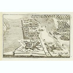
Batavia, L'an 1629.
Uncommon of Batavia (Jakarta) in 1629.From a travel book describing the early Dutch voyages by René Augustin Constantin de Renneville Recueil des voiages qui ont servi ...
Date: Amsterdam, E. Rogers, 1702
Selling price: ????
Please login to see price!
Sold in 2013
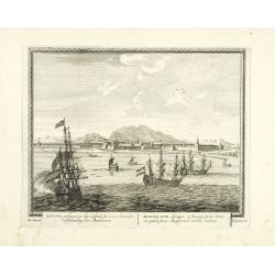
(Bird's eye view of the Bay of Bantam.)
Bird's eye view of the Bay of Bantam after Willem Lodewijcksz.From the French reissue of the account of early Dutch voyages first published in 1608 by Commelin. The Frenc...
Date: Amsterdam, E. Roger, 1702
Selling price: ????
Please login to see price!
Sold in 2014
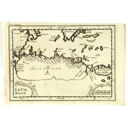
Iava Maior.
Nice early map of Java. From the French reissue of the account of early Dutch voyages first published in 1608 by Commelin. The French translation was carried out by René...
Date: Amsterdam, E. Roger, 1702
Selling price: ????
Please login to see price!
Sold in 2013
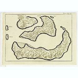
( Detroit de Baly / Detroit de Ballabuan. )
Nice early map of Bali. From the French reissue of the account of early Dutch voyages first published in 1608 by Commelin. The French translation was carried out by René...
Date: Amsterdam, E. Roger, 1702
Selling price: ????
Please login to see price!
Sold in 2013
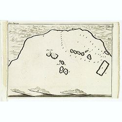
(Gunanappi / Wayer / Nera / Pulorin / Puloway .)
Uncommon map of islands in the Banda Sea. Several islands and villages are named, Wayer, Nera, Pulorin, Puloway, Lontoor, Ortattan and Combeer.From the French reissue of ...
Date: Amsterdam, E. Roger, 1702
Selling price: ????
Please login to see price!
Sold in 2012
![[map of South East Asia ]](/uploads/cache/31872-250x250.jpg)
[map of South East Asia ]
The map is an expanded version of De Bry's "Mar di India", with the inclusion of an inset map of Buton (Botton I. 140x105mm.). The Straits of Buton, highlighted...
Date: Amsterdam, E. Rogers, 1702
Selling price: ????
Please login to see price!
Sold in 2012
Nova Et Vera Exhibitio Gerographica Insularum Marianarum . . .
Attractive map of the Philippines, Japan, Korea and Indonesia with an inset of the island Guam, by the Jesuit Heinrich Scherer, printed in for Scherer's 'Atlas Novus'. Se...
Date: Munich, c.1702
Selling price: ????
Please login to see price!
Sold in 2016
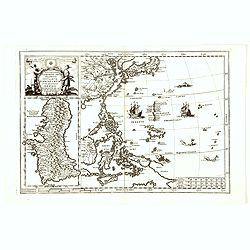
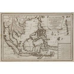
A New Map of the East Indies taken form Mr. de Fer's Map of Asia.
Striking scarce regional map of India and the East Indies, extending from Southeast Asia, the Philippines, China and Tibet in the East to India and the Maldives in the We...
Date: London, 1703
Selling price: ????
Please login to see price!
Sold in 2015
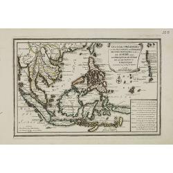
Presqu'Isle De L'Inde De Ca Le Golfe Du Gange/Presqu'Isle De L'Inde De La Le Golfe Du Gange.
Pair of maps, one of the Indian peninsula and Sri Lanka, and another of Southeast Asia, including Singapore.
Date: Paris, c.1704
Selling price: ????
Please login to see price!
Sold in 2012
Les Isles Philippines
Striking map of the East Indies. From De Fer's Atlas Curieux. Nice wide margins and decorative cartouche.
Date: Paris, 1705
Selling price: ????
Please login to see price!
Sold in 2009
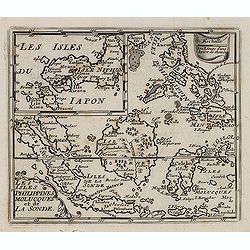
Les isles Philippines, Molucques../Les isles du Iapon.
A map of the Indonesian and Philippines islands with an insert showing the three main Japanese islands, by Nicolas De Fer, Royal French Geographer.
Date: Paris, 1705
Selling price: ????
Please login to see price!
Sold in 2015
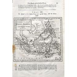
The Principal Islands of the East Indies.
A detailed copper engraved map of Indonesia and the Philippines, that Includes a small tip of New Holland (Australia) and names the Singapore Strait. With interesting tex...
Date: London, ca 1705
Selling price: ????
Please login to see price!
Sold in 2019
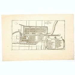
Plan de Batavia.
An excellent example of de Fer's town plan of Batavia (Jakarta) produced early in the 18th century, when the city and region was under the direct control and influence of...
Date: Paris, 1705
Selling price: ????
Please login to see price!
Sold in 2021
Les Isles Philippines et celles Des Larrons oude Marianes, Les Isles Moluques et de la Sonde, avec la Presqu'isle de L'Inde de la le Gange ou Orientale?
A map of the Malaysia, Indonesian and Philippines islands, by Nicolas De Fer, Royal French Geographer. The island of Taiwan is labeled "I.Formosa ou Bel Isle".
Date: Paris, 1706
Selling price: ????
Please login to see price!
Sold in 2015
Les Isles Philippines et celles Des Larrons oude Marianes, Les Isles Moluques et de la Sonde, avec la Presqu\'isle de L\'Inde de la le Gange ou Orientale.
A map of the Malaysia, Indonesian and Philippines islands, by Nicolas De Fer, Royal French Geographer. The island of Taiwan is labeled "I.Formosa ou Bel Isle".
Date: Paris, 1706
Selling price: ????
Please login to see price!
Sold in 2010
