Browse Listings in Asia > South East Asia > Moluccas
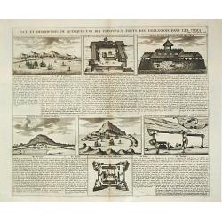
Vue et description de quelques-uns des principaux forts des Hollandois dans les Indes.
Henri Abraham Chatelain was a Amsterdam-based geographer and publisher. His main product is the Atlas Historique et Méthodique, in seven volumes, published between 1710 ...
Date: Amsterdam, 1710-20.
Selling price: ????
Please login to see price!
Sold
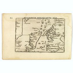
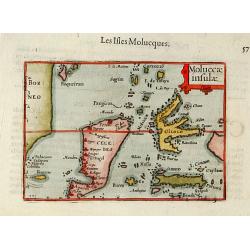
Moluccae Insulae.
An attractive miniature map of the Molucca Islands, formerly known as the 'Spice Islands', in Indonesia, published by Petrus Bertius, in Amsterdam at the beginning of the...
Date: Amsterdam, 1606
Selling price: ????
Please login to see price!
Sold in 2019
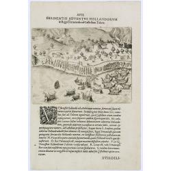
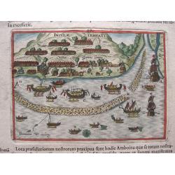
Delineatio Adventus Hollandorum. (Ternate Island)
Arrival of the Dutch at Ternate Island.Theodore de Bry, a German engraver and book dealer, began a compilation of early voyages in 1590 and had published six parts at the...
Date: Frankfurt, 1609
Selling price: ????
Please login to see price!
Sold in 2017
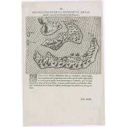
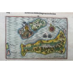
Delineatio Duorum Oppidorum, Ortat.
Early map of the Banda Islands.Theodore de Bry, a German engraver and book dealer, began a compilation of early voyages in 1590 and had published six parts at the time of...
Date: Frankfurt, 1609
Selling price: ????
Please login to see price!
Sold in 2025
![Moluccae Insulae [Molucca].](/uploads/cache/13293-250x250.jpg)
Moluccae Insulae [Molucca].
A miniature map of Moluccas, centered on Celebes Islands. Title cartouche on the upper right corner.First published in 1598 in his Caert-Thresoor, the plates were execute...
Date: Amsterdam / Frankfurt, 1609
Selling price: ????
Please login to see price!
Sold in 2016
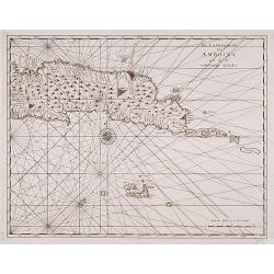
Banda isles - Banda, Poelepetacke and Groene Ape
Two early maps on one sheet. Amboina and the Banda Isles: Banda, Pulau Run and Gunung Api on the verso of the sheet. From the description by Pontanus of the second expedi...
Date: Amsterdam, 1611
Selling price: ????
Please login to see price!
Sold in 2014
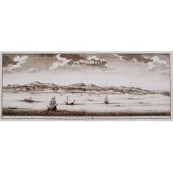
View of the town of Gammelamme, situated on Ternate.
View of the town of Gammelamme [Gamalama] on Ternate, where the Dutch established a trading post. Includes Dutch ships, native boats or proas, indication of the reef, nat...
Date: Amsterdam, 1611
Selling price: ????
Please login to see price!
Sold in 2020
Banda isles - Banda, Poelepetacke and Groene Ape.
Two early and highly attractive miniature maps on one sheet. Amboina and the Banda Isles: Banda, Pulau Run and Gunung Api on the verso of the sheet. From the description ...
Date: Amsterdam, 1614
Selling price: ????
Please login to see price!
Sold in 2022
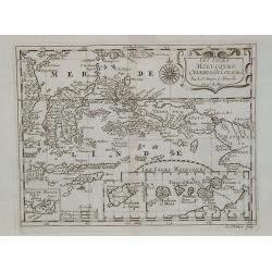
Moluccae insulae.
The Indonesian islands of Celebes, Banda, Gilolo, etc., lying between Borneo and New Guinea. Although Gilolo is shown in its approximately correct shape, Celebes is unrec...
Date: Amsterdam 1616
Selling price: ????
Please login to see price!
Sold
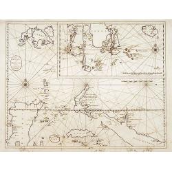
![[Islands of Amboina and Nera.]](/uploads/cache/40086-250x250.jpg)
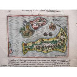
[Islands of Amboina and Nera.]
On the island of Amboina, the Dutch have a royal castle with a strong fortress. ‘E’ marks some homes of the inhabitants, ‘F’ shows the island itself, along with i...
Date: Frankfurt, M.Merian, 1633
Selling price: ????
Please login to see price!
Sold in 2023
![[Islands of Macian and Bacian.]](/uploads/cache/40085-250x250.jpg)
[Islands of Macian and Bacian.]
This shows the features of the islands Macian and Bacian. ‘A’ is the Isle of Macian, with its angle towards noon from the Equator, being 8 minutes from midnight, ‘B...
Date: Frankfurt, M.Merian, 1633
Selling price: ????
Please login to see price!
Sold in 2023
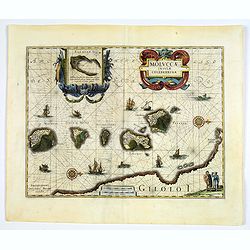
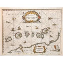
Insularum Moluccarum Nova descriptio.
A decorative map of some of the Spice Islands, off the west coast of the island of Halmahera in the eastern part of the archipelago. The map is oriented with north to the...
Date: Amsterdam, after 1633
Selling price: ????
Please login to see price!
Sold in 2017
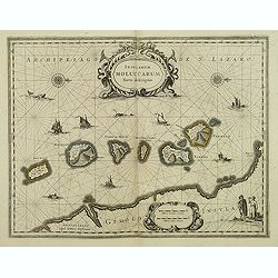
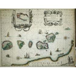
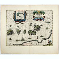
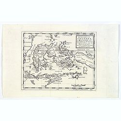
Moluccae Insulae Celeberrimae.
The map shows the islands of Ternate, Tidore, Mot and Makian. In the top right corner an inset map of the island of Bachian is shown. Latin text.
Date: Amsterdam, 1635
Selling price: ????
Please login to see price!
Sold in 2009
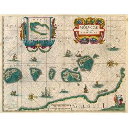
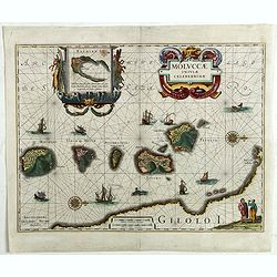
Moluccae Insulae Celeberrimae.
Showing the geographical features of the islands, and decorated with ships, sea monsters and a handsome cartouche. With an inset of Bachian island.One of the most appeali...
Date: Amsterdam, 1638
Selling price: ????
Please login to see price!
Sold in 2010
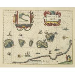
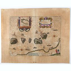
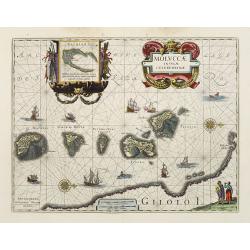
MOLUCCAE Insulae Celeberrimae.
The earliest full-scale and highly decorative map of the "Spice Islands". In addition to a sumptuous title cartouche, the map features an inset of the Island of...
Date: Amsterdam, 1635-1638
Selling price: ????
Please login to see price!
Sold
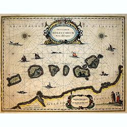
Insularum Moluccarum Nova descriptio.
Exquisite map of the famous Spice Islands based on the islands described by Jan Huyghen van Linschoten.This map was the first large scale map of the region and depicts th...
Date: Amsterdam, 1640
Selling price: ????
Please login to see price!
Sold in 2018
Insularum Moluccarum Nova descriptio.
Exquisite map of the famous Spice Islands based on the islands described by Jan Huyghen van Linschoten. This map was the first large scale map of the region and depicts t...
Date: Amsterdam, 1640
Selling price: ????
Please login to see price!
Sold
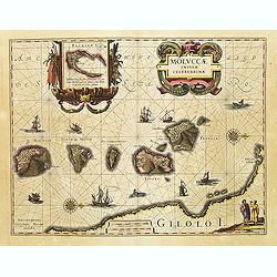
Moluccae Insulae Celeberrimae.
Nice map of the Moluccan Islands in the Indonesian Archipelago.Beautiful cartouches. Verso blanc.
Date: Amsterdam, c 1640
Selling price: ????
Please login to see price!
Sold
Moluccae Insulae Celeberrimae.
This plate was originally engraved in the 1620, and published as a loose-sheet by Jodocus Hondius II. At his death in August 1629 this map was, among 39 other copper plat...
Date: Amsterdam, 1640
Selling price: ????
Please login to see price!
Sold in 2020
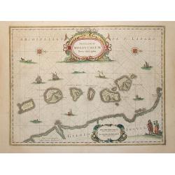
Insularum Moluccarum Nova descriptio.
The small spice islands off the west coast of the island of Halmahera in the eastern part of the archipelago. With an imposing title cartouche, together with finely drawn...
Date: Amsterdam, 1640
Selling price: ????
Please login to see price!
Sold in 2009
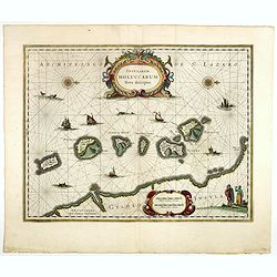
Insularum Moluccarum Nova descriptio.
Exquisite map of the famous Spice Islands based on the islands described by Jan Huyghen van Linschoten. This map was the first large scale map of the region and depicts t...
Date: Amsterdam, 1640
Selling price: ????
Please login to see price!
Sold in 2017
Insularum Moluccarum Nova descriptio.
Exquisite map of the famous Spice Islands based on the islands described by Jan Huyghen van Linschoten.This map was the first large scale map of the region and depicts th...
Date: Amsterdam, 1640
Selling price: ????
Please login to see price!
Sold in 2020
Moluccae Insulae Celeberrimae.
This plate was originally engraved in the 1620, and published as a loose-sheet by Jodocus Hondius II. At his death in August 1629 this map was, among 39 other copper plat...
Date: Amsterdam, 1640
Selling price: ????
Please login to see price!
Sold in 2017
Insularum Moluccarum Nova descriptio - Amstelodami, Apud Ioannem Ianßonium.
Shows the islands Moluccas of Indonesia. Very decorative map.
Date: Amsterdam, 1645
Selling price: ????
Please login to see price!
Sold in 2013
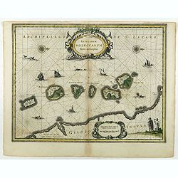
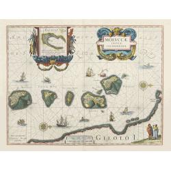
Moluccae Insulae Celeberrimae.
Showing the geographical features of the islands, and decorated with ships, rhumb lines, ships and sea monsters and a handsome cartouche. With an inset of Bachian island....
Date: Amsterdam, ca. 1650
Selling price: ????
Please login to see price!
Sold in 2017
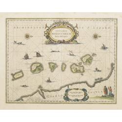
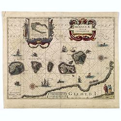
Moluccae Insulae Celeberrimae.
Showing the geographical features of the spice islands, and decorated with ships, sea monsters and a handsome cartouche. In addition to a sumptuous title cartouche, the m...
Date: Amsterdam, 1658
Selling price: ????
Please login to see price!
Sold in 2022
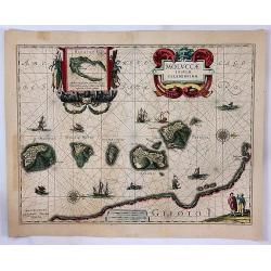
Moluccae Insulae Celeberrimae.
Showing the geographical features of the spice islands, and decorated with ships, sea monsters and a handsome cartouche. In addition to a sumptuous title cartouche, the m...
Date: Amsterdam, 1658
Selling price: ????
Please login to see price!
Sold
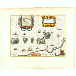
Moluccae Insulae Celeberrimae.
Showing the geographical features of the spice islands, and decorated with ships, sea monsters and a handsome cartouche. In addition to a sumptuous title cartouche, the m...
Date: Amsterdam, 1658
Selling price: ????
Please login to see price!
Sold
MOLUCCAE Insulae Celeberrimae.
A highly decorative map of the "Spice Islands".
Date: Amsterdam, ca. 1660
Selling price: ????
Please login to see price!
Sold in 2018
Moluccae Insulae Celeberrimae.
A striking map of the famous Spice Islands, originally described by Van Linschoten. This map was the first large-scale map of the region and depicts the islands that prov...
Date: Amsterdam, 1662
Selling price: ????
Please login to see price!
Sold in 2017
Moluccae Insulae Celeberrimae.
Showing the geographical features of the spice islands, and decorated with ships, sea monsters and a handsome cartouche. In addition to a sumptuous title cartouche, the m...
Date: Amsterdam, 1663
Selling price: ????
Please login to see price!
Sold in 2016
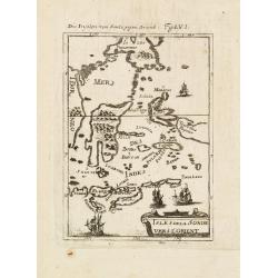
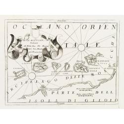
Isles dela Sonde vers l'Orient.
A late 17th century miniature map of the Moluccas and southern part of the Philippines, by Allain Manneson Mallet (1630-1706), a well traveled military engineer and geogr...
Date: Paris, 1683
Selling price: ????
Please login to see price!
Sold in 2013
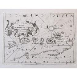
![Isle de la Sonde vers L\'Orient. [Moluccan Islands]](/uploads/cache/26298-250x250.jpg)
Isle de la Sonde vers L\'Orient. [Moluccan Islands]
A charming late 17th century map of the Moluccas Islands. By Allain Manneson Mallet (1630-1706), a well traveled military engineer and geographer who worked in 17th centu...
Date: Frankfurt, 1684
Selling price: ????
Please login to see price!
Sold in 2008
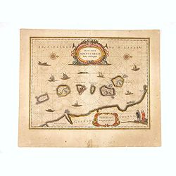
Insularum Moluccarum Nova descriptio.
The small spice islands off the west coast of the island of Halmahera in the eastern part of the archipelago. With an imposing title cartouche, together with finely drawn...
Date: Amsterdam, 1690
Selling price: ????
Please login to see price!
Sold in 2012
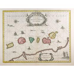
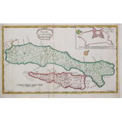
Le Molucche, Dedicate al Molto Rev: Pre Maestro Carlo Tosi, Min Congio Provinceale.
An uncommon engraved map of the Maluku or Moluccas Islands in Indonesia. In the past the islands were also known as the 'Spice Islands'. The islands are shown with their ...
Date: Venice, ca. 1690
Selling price: ????
Please login to see price!
Sold in 2017
Le Molucche..
Map of the Moluccas Islands with decorative title cartouche. West to the top. By the remarkable Vincenzo Coronelli, (1650-1718), a Franciscan Friar and appointed General ...
Date: Venice 1690
Selling price: ????
Please login to see price!
Sold
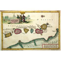
Les Isles Molucques, Celebes, Gilolo, &c. ?
Shows the islands east of Borneo, up to and including New Guinea. From a pocket-atlas published by F. Halma.
Date: Amsterdam, 1700
Selling price: ????
Please login to see price!
Sold in 2009
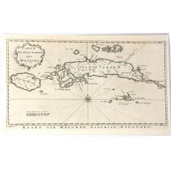
De Moluccos, of Speceri-dragende Eilanden Tussen Cilolo en Celebes gelegen.
Pieter van der Aa was a prolific publisher. He published a.o. ' Naaukeurige versameling der gedenkwaardigste zee- en land-reysen', a series of accounts of voyages (1706-0...
Date: Leiden, 1707
Selling price: ????
Please login to see price!
Sold
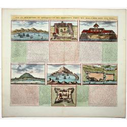
Vue et description de quelques-uns des principaux forts des Hollandois dans les Indes. (Dutch Forts).
A clean plate with seven detailed views illustrating the most important Dutch trading outposts and fortified colonial possessions in the East Indies. This plate includes ...
Date: Amsterdam, 1719
Selling price: ????
Please login to see price!
Sold in 2019
De Landvoogdy der Moluccos..
Fine chart depicting the Moluccas islands. Little interior detail is given but the coastlines, settlements and principal coastal features are identified. To the lower rig...
Date: Amsterdam, 1724
Selling price: ????
Please login to see price!
Sold in 2008
De Landvoogdy der Moluccos..
"Fine chart depicting the Moluccas islands. Little interior detail is given but the coastlines, settlements and principal coastal features are identified. To the low...
Date: Amsterdam 1724
Selling price: ????
Please login to see price!
Sold
![Western part of the island Amboina with Boero. [no title]](/uploads/cache/15930-250x250.jpg)
Western part of the island Amboina with Boero. [no title]
"Decorative map of the western tip of the islands of Amboina.Françcois Valentijn (1666-1727), a missionary, worked at Amboina from 1684 to 1694 and 1705 t...
Date: Amsterdam 1726
Selling price: ????
Please login to see price!
Sold
De landvoogdy van Amboina met de elf onderhoorige Eylanden.
"Decorative map of the eastern tip of the islands of Amboina.Françcois Valentijn (1666-1727), a missionary, worked at Amboina from 1684 to 1694 and 1705 t...
Date: Amsterdam 1726
Selling price: ????
Please login to see price!
Sold
Amboina.
"Decorative panoramic view of the island of Amboina with European vessels in the foreground.Françcois Valentijn (1666-1727), a missionary, worked at Amboi...
Date: Amsterdam 1726
Selling price: ????
Please login to see price!
Sold
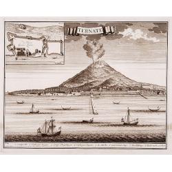
Ternate.
"Decorative panoramic view of Ternate with European vessels in the foreground. In upper left corner inset plan of the Fortress Oranje.Françcois Valentijn ...
Date: Amsterdam 1726
Selling price: ????
Please login to see price!
Sold
De Landvoogdy der Moluccos met de aangrenzende Eylanden.
Fine chart depicting the Moluccas islands and the northern part of Celebes, nowadays Sulawesi with an inset depicting the southern part of Celebes with the island Bouro.L...
Date: Amsterdam, 1728
Selling price: ????
Please login to see price!
Sold
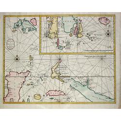
The Island of Celebes, or Macassar with the Islands of Banda, Amboyna. . .
A detailed map of the islands from Eastern Brunei to Timor and part of New Guinea, centered on the Moluccas, including the famous Spice Islands that were once the heart o...
Date: London, ca. 1730
Selling price: ????
Please login to see price!
Sold in 2019
Insularum Moluccarum ..
Exquisite map of the famous Spice Islands based on the islands described by Jan Huyghen van Linschoten. This map was the first large scale map of the region and depicts t...
Date: Amsterdam, 1750
Selling price: ????
Please login to see price!
Sold in 2020
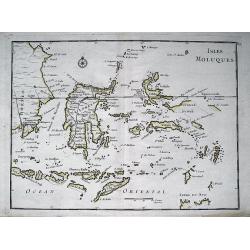
ISLES MOLUQUES.
Highly detailed map of the famous Spice Islands (Maluku Islands or the Moluccas). Includes also Sulawesi, Bali, Timor, part of Borneo, New-Guinea with unfinished coast li...
Date: Paris, c1750
Selling price: ????
Please login to see price!
Sold in 2013
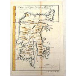
Carte de L'Isle Celebes ou Macassar.
Fine little copper engraved map of Celebes Island, Makassar (Buginese-Makassar language:– sometimes spelled Macassar, Mangkasara) – It is the provincial capital of So...
Date: Paris, 1750
Selling price: ????
Please login to see price!
Sold in 2015

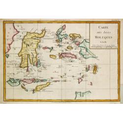
Carte des Isles Voisines des Moluques.
Map of the province of Moluccas, Indonesia including Ceram, Bouro, Amboine and Neyra. Published by Pierre de Hondt for Prevost's "L'HISTOIRE GENERALE DES VOYAGES&quo...
Date: Paris, ca.1750
Selling price: ????
Please login to see price!
Sold in 2016
Carte des isles voisines des Moluques
A striking antique map of the Ceram, Ambon and the Banda islands close to Indonesia. Published by Antonine de Prevost d' Exile's “Histoire Generale des Voyages”. (Fro...
Date: Amsterdam, 1754
Selling price: ????
Please login to see price!
Sold in 2019
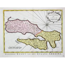
Carte Particulare de l' Isle d' Amboine.
Jaques Nicolas Bellin (1702-720) was the most important French hydrographer of the 18th century. Sea-atlas 'Hydrographique Français' , 1756-65, atlas to accompany Prévo...
Date: Amsterdam, c. 1755
Selling price: ????
Please login to see price!
Sold in 2009
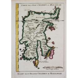
Kaart van 't Eiland Celebes of Makassar.
Jaques Nicolas Bellin (1702-720) was the most important French hydrographer of the 18th century. Sea-atlas 'Hydrographique Français' , 1756-65, atlas to accompany Prévo...
Date: Amsterdam, c. 1760
Selling price: ????
Please login to see price!
Sold
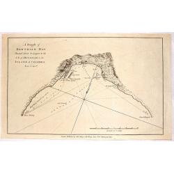
A Draught of Bonthain Bay Situated About 30 Leagues to the S.E. of Macassar in the Island of Celebes.
Interesting copper engraved nautical chart featuring the Bantaeng Region of Indonesia.< Relief shown pictorially and by hachures with depths by soundings.
Date: London, 1772
Selling price: ????
Please login to see price!
Sold in 2016
Carte des Isles Moluques.
Rigobert Bonne (1727-1795), French cartographer. His maps are found in a.o. Atlas Moderne (1762), Raynal's Histoire Philos. du Commerce des Indes (1774) and Atlas Encyclo...
Date: Paris, 1774
Selling price: ????
Please login to see price!
Sold in 2009
Kaart van 't Eyland Amboine.
An uncommon map of the island of Ambon.
Date: Almelo, 1775
Selling price: ????
Please login to see price!
Sold in 2009
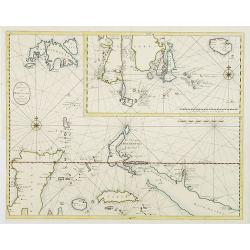
![[Lot of 2 manuscript maps] Schetskaart van het westelijk vaarwater naar de reede van Ternate. [together with ] Sketch of the island of Ternate, Tidore and to the Southward.](/uploads/cache/47989-250x250.jpg)
[Lot of 2 manuscript maps] Schetskaart van het westelijk vaarwater naar de reede van Ternate. [together with ] Sketch of the island of Ternate, Tidore and to the Southward.
Two rare manuscript maps being one general map of the spice islands and a detailed map of the South Western Channel in front of the town Ternate with the island "Noo...
Date: Ternate ?, ca. 1800-1810
Selling price: ????
Please login to see price!
Sold in 2022
Amboine.
From "Voyage de la corvette l'Astrolabe exécuté par Ordre du Roi pendant les années 1826 - 1827 - 1828 - 1829 sous le commandement de M. Jules Dumont d'Urville, C...
Date: Paris, 1830
Selling price: ????
Please login to see price!
Sold in 2011
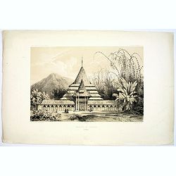
Mosquee de Ternate.
A handsome lithograph of the mosque on the eastern Indonesian Island of Ternate. Plate 107 taken from the 'Voyage au Pole et dans L'Oceanie…'br >Departing in late 18...
Date: Paris, 1842
Selling price: ????
Please login to see price!
Sold in 2016
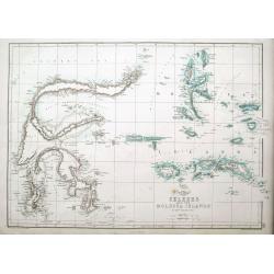
Celebes and the Molucca Islands.
A highly detailed map of the islands, also known as the Spice Islands, Celebes and Maluku Islands or the Moluccas, with many even small islands depicted. It depicts bays,...
Date: London, ca 1860
Selling price: ????
Please login to see price!
Sold in 2018
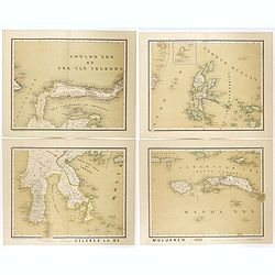
Celebes en de Molukken in vier bladen.
Very detailed four-sheet map of Celes and the Moluccas on a scale of 1:1800000, taken from "Atlas van Nederlandsch Oost- en West-Indie," prepared by a doctor I....
Date: Amsterdam, Seyffardt, 1884
Selling price: ????
Please login to see price!
Sold in 2017
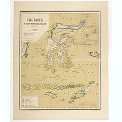
Celebes, de kleine Soenda eilanden, enz. Schaal van 1:4200000.
Very detailed two sheet map of Moluccas, taken from "Atlas van Nederlandsch Oost- en West-Indie", prepared by doctor I. Dornseiffen, and published by published ...
Date: Amsterdam, Seyffardt, 1884
Selling price: ????
Please login to see price!
Sold in 2017
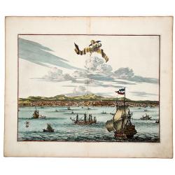
La Ville de l' AMBOINE, Capitale des Isles Molucques.
An attractive hand colored copperplate view of Ambon (Moluccas) by Pierre van der Aa. Shows the capital of Ambon Island with several ships in foreground during the the Du...
Date: Leiden, ca 1719
Selling price: ????
Please login to see price!
Sold in 2019
