Browse Listings in Asia > South East Asia
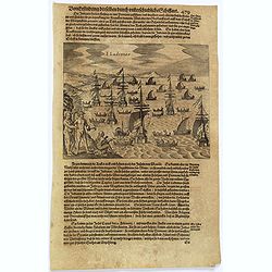
![[Creatures of Java].](/uploads/cache/37950-250x250.jpg)
[Creatures of Java].
Two text engravings from "Premier livre de l'histoire de la navigation aux Indes Orientales, par les hollandois, et des choses a eux advenues . . . ", being the...
Date: Amsterdam, Cornille Nicolas, 1609
Selling price: ????
Please login to see price!
Sold in 2017
![[Java].](/uploads/cache/37965-250x250.jpg)
[Java].
Wood block engraved coastal profiles set in text from "Premier livre de l'histoire de la navigation aux Indes Orientales, par les hollandois, et des choses a eux adv...
Date: Amsterdam, Cornille Nicolas, 1609
Selling price: ????
Please login to see price!
Sold in 2025
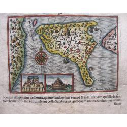
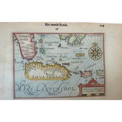
Baly and Java.
Map of Bali in present-day Indonesia. Includes inset of temple and temple grounds. Even though this map is much smaller than an atlas map from Blaeu, Hondius or Ortelius,...
Date: Amsterdam, 1611
Selling price: ????
Please login to see price!
Sold in 2014
The town of Madura on the island Madura: Madurensium
An early, rare view of the town of Madura on the island Madura with the 4 ships of Houtman's fleet. On verso the inhabitants are showing the Houtman’s crew their skills...
Date: Amsterdam, 1611
Selling price: ????
Please login to see price!
Sold in 2014
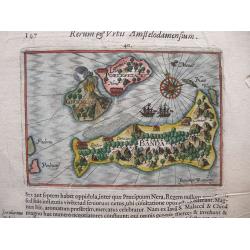
Banda isles - Banda, Poelepetacke and Groene Ape
Two early maps on one sheet. Amboina and the Banda Isles: Banda, Pulau Run and Gunung Api on the verso of the sheet. From the description by Pontanus of the second expedi...
Date: Amsterdam, 1611
Selling price: ????
Please login to see price!
Sold in 2014
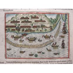
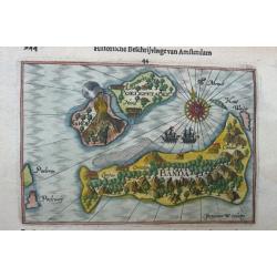
View of the town of Gammelamme, situated on Ternate.
View of the town of Gammelamme [Gamalama] on Ternate, where the Dutch established a trading post. Includes Dutch ships, native boats or proas, indication of the reef, nat...
Date: Amsterdam, 1611
Selling price: ????
Please login to see price!
Sold in 2020
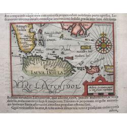
Java, Borneo and Southern Sumatra.
An early, rare and beautiful map of Java and the southern part of Sumatra and Borneo. Includes Bali and Cambava (present-day Mataram?). Also includes shoals. Fine calligr...
Date: Amsterdam, 1611
Selling price: ????
Please login to see price!
Sold in 2014
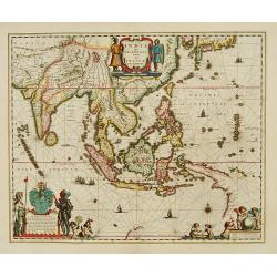
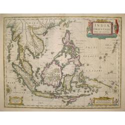
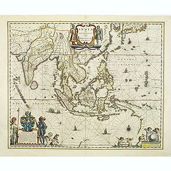
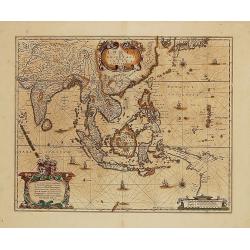
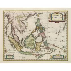
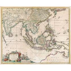
Indiae Orientalis Insularum que. . .
Covering all of South East Asia, China, Japan, Philippines, and the west coast of North America. Like most cartographers of the sixteenth and seventeenth centuries, Ortel...
Date: Antwerp, 1570-1612
Selling price: ????
Please login to see price!
Sold in 2018
Indiae Orientalis, Insularumque Adiacientium Typus.
From the 1612 edition of Ortelius' "Theatrum Orbis Terrarum", the first modern Atlas. French text on verso.A fine map showing India, China and New Guinea with m...
Date: Antwerp, 1612
Selling price: ????
Please login to see price!
Sold in 2020
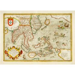
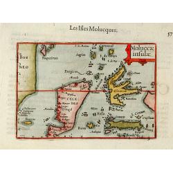
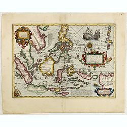
Insulae Indiae Orientalis praecipuae, in quibus Moluccae celeberrimae sunt.
Beautiful Southeast Asia map by Mercator-Hondius, in bright original colors. Two beautiful new maps of Southeast Asia were created by the Dutch mapmaker Jodocus Hondius f...
Date: Amsterdam, 1613
Selling price: ????
Please login to see price!
Sold in 2010
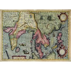
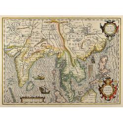
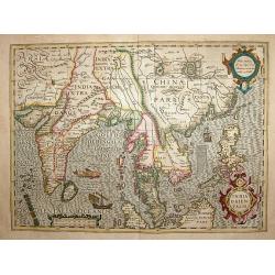
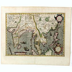
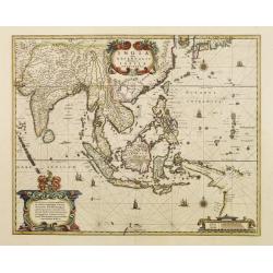
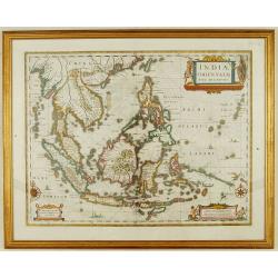
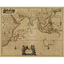
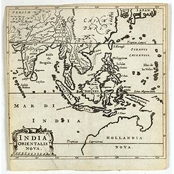
India Orientalis
This is an early views of India, China, and Southeast Asia at the beginning of Dutch expansion into the area. This is a very attractive, boldly engraved map in the fine...
Date: Amsterdam, (1606) 1613
Selling price: ????
Please login to see price!
Sold in 2012
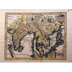
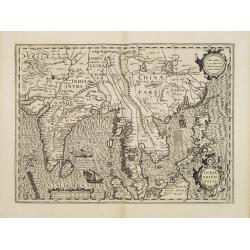
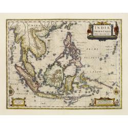
India Orientalis.
Published in Hondius' editions of the Mercator Atlas from 1606 onwards, showing the Indian subcontinent, the Malay peninsula, Siam and Cambodia, China and the Philippines...
Date: Amsterdam, 1613
Selling price: ????
Please login to see price!
Sold in 2016
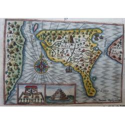
Baly and Java.
A map of Bali in present-day Indonesia. It includes insets of the temple and temple grounds. Decorative and with a compass rose. Even though this map is much smaller than...
Date: Amsterdam, 1614
Selling price: ????
Please login to see price!
Sold in 2021
Banda isles - Banda, Poelepetacke and Groene Ape.
Two early and highly attractive miniature maps on one sheet. Amboina and the Banda Isles: Banda, Pulau Run and Gunung Api on the verso of the sheet. From the description ...
Date: Amsterdam, 1614
Selling price: ????
Please login to see price!
Sold in 2022
Java, Borneo, and Southern Sumatra.
An early, scarce, and beautiful map of Java and the southern part of Sumatra and Borneo. It includes Bali and Cambava (present-day Mataram?). Also includes shoals, and fi...
Date: Amsterdam, 1614
Selling price: ????
Please login to see price!
Sold in 2020
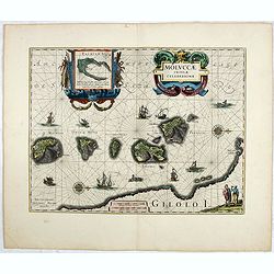
Moluccae insulae.
The Indonesian islands of Celebes, Banda, Gilolo, etc., lying between Borneo and New Guinea. Although Gilolo is shown in its approximately correct shape, Celebes is unrec...
Date: Amsterdam 1616
Selling price: ????
Please login to see price!
Sold
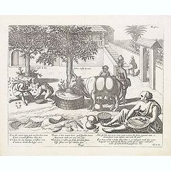
Ecce tibi ramum nigra quem nox suavibus ornat. . .
Interesting print of an agricultural compound with trees, cows and the preparation of Betel nut (Arecca) in the foreground. Text in Latin and Dutch along lower edge. Engr...
Date: Amsterdam, 1617
Selling price: ????
Please login to see price!
Sold in 2015
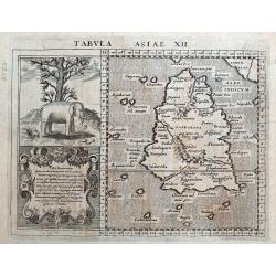
Tabula Asiae XII (Sri Lanka or Sumatra).
A fine Ptolemaic map of the Island of "Taprobana". Some sources say although this map is titled Taprobana (Sri Lanka or Ceylon), it is actually the island of Su...
Date: Amsterdam, 1617
Selling price: ????
Please login to see price!
Sold in 2018
India Orientalis
Beautiful colored map of India, the Malay Peninsula, China and the Philippines, Thailand and Cambodia and parts of Sumatra with Borneo from a French edition of the Mercat...
Date: Amsterdam, 1619
Selling price: ????
Please login to see price!
Sold in 2008
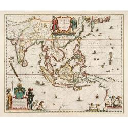
INDIA ORIENTALIS
Attractive map of South East Asia, extending from India with the Maldives, Sri Lanka, to China, the Philippines, and Indonesia with parts of Sumatra and Borneo islands. V...
Date: c1620
Selling price: ????
Please login to see price!
Sold in 2013
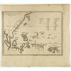
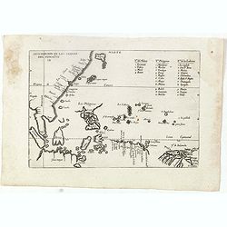
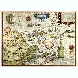
Descripcion de las indias del Poniente. 14.
Early map of the East Indies from Bengal to the Solomon Islands and north to Japan. Based on the manuscript map of López de Velasco, the earliest map to name all of the ...
Date: Amsterdam, Michel Colin, 1622
Selling price: ????
Please login to see price!
Sold in 2018
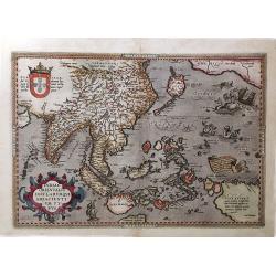
Insulae Indiae Orientalis Praecipuae, In quibus Moluccae.
A beautiful new map of Southeast Asia created by the Dutch mapmaker Jodocus Hondius for an enlarged issue of the Mercator Atlas of 1606. Focusing on the islands. Geograph...
Date: Amsterdam, 1623
Selling price: ????
Please login to see price!
Sold in 2018
Descripcion de las Indias Ocidentalis.
De Bry's version of this important map of China, Southeast Asia, the Philippines, etc., it first appeared in Herrera's Descripcion de las Indias Ocidentales, first publis...
Date: Frankfurt, 1623-1624
Selling price: ????
Please login to see price!
Sold in 2016
INDIA orientalis
Attractive map of South East Asia entitled "Hondius his Map of the East Indies", extending from India with the Maldives to Japan and China, also includi...
Date: London, 1625
Selling price: ????
Please login to see price!
Sold in 2009
Insulae Indiae Orientalis Praecipuae, In quibus Moluccae..
A beautiful new map of Southeast Asia created by the Dutch mapmaker Jodocus Hondius for an enlarged issue of the Mercator Atlas of 1606. Focusing on the islands. Geograph...
Date: Amsterdam, 1628
Selling price: ????
Please login to see price!
Sold in 2015
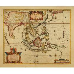
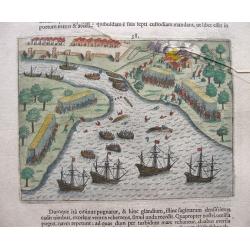
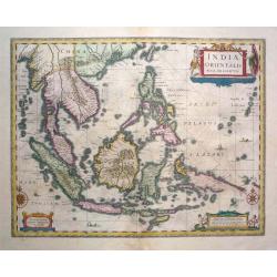
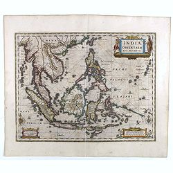
India quae Orientalis dicitur, et Insulae Adiacentes.
An important Dutch map of South East Asia, noteworthy for being the first map to include, albeit incompletely, the discoveries made by the Dutch vessel Duyfken in 1605-06...
Date: Amsterdam, 1629
Selling price: ????
Please login to see price!
Sold in 2013
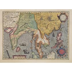
India Orientalis.
Published in Hondius' editions of the Mercator Atlas from 1606 onwards, showing the Indian subcontinent, the Malay Peninsula, Siam and Cambodia, China and the Philippines...
Date: Amsterdam, 1630
Selling price: ????
Please login to see price!
Sold in 2011
India Orientalis.
Published in Hondius' editions of the Mercator Atlas from 1606 onwards, showing the Indian subcontinent, the Malay Peninsula, Siam and Cambodia, China and the Philippines...
Date: Amsterdam 1630
Selling price: ????
Please login to see price!
Sold
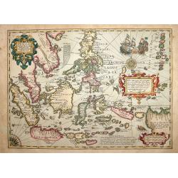
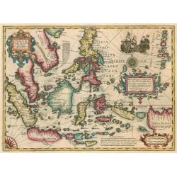
Insulae Indiae Orientalis.
One of the most decorative maps of the Indonesian Archipelago, including the Philippines, Malaya and further India. Ships in the sea and a beautiful title cartouche add t...
Date: Amsterdam, 1630
Selling price: ????
Please login to see price!
Sold in 2008
Insulae India Orientalis.
A beautiful map of South East Asia. With Italian text on verso.
Date: Amsterdam, Cloppenburg, 1630
Selling price: ????
Please login to see price!
Sold in 2011

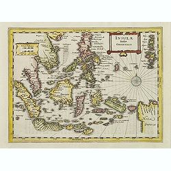
Insulae Indiae Orientalis.
Map of South East Asia with good detail on the Philippines from the rare Cloppenburg edition slightly larger format and more scarce edition of the Mercator/Hondius "...
Date: Amsterdam, 1630
India Orientalis.
Published in Hondius' editions of the Mercator Atlas from 1606 onwards, showing the Indian subcontinent, the Malay Peninsula, Siam and Cambodia, China and the Philippines...
Date: Amsterdam, 1630
Selling price: ????
Please login to see price!
Sold in 2019
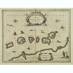
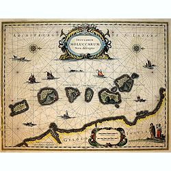
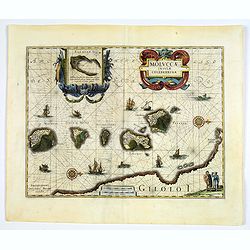
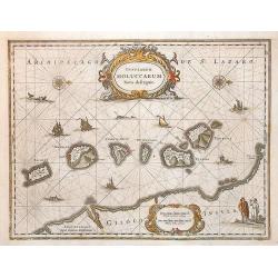
Insularum Moluccarum Nova descriptio.
A decorative map of some of the Spice Islands, off the west coast of the island of Halmahera in the eastern part of the archipelago. The map is oriented with north to the...
Date: Amsterdam, after 1633
Selling price: ????
Please login to see price!
Sold in 2017
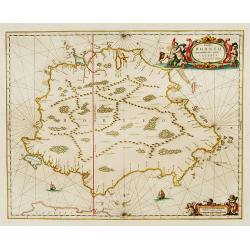
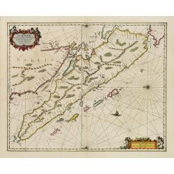
![[Borneo Insula.]](/uploads/cache/40082-250x250.jpg)
[Borneo Insula.]
Important map of Bornea based on a map by Olivier van Noort (1558-1627), who on his turn mostly adapted information from earlier maps such as those by Langenes and van Li...
Date: Frankfurt, M.Merian, 1633
Selling price: ????
Please login to see price!
Sold in 2025
![[Islands of Macian and Bacian.]](/uploads/cache/40085-250x250.jpg)
[Islands of Macian and Bacian.]
This shows the features of the islands Macian and Bacian. ‘A’ is the Isle of Macian, with its angle towards noon from the Equator, being 8 minutes from midnight, ‘B...
Date: Frankfurt, M.Merian, 1633
Selling price: ????
Please login to see price!
Sold in 2023
![[Islands of Amboina and Nera.]](/uploads/cache/40086-250x250.jpg)
[Islands of Amboina and Nera.]
On the island of Amboina, the Dutch have a royal castle with a strong fortress. ‘E’ marks some homes of the inhabitants, ‘F’ shows the island itself, along with i...
Date: Frankfurt, M.Merian, 1633
Selling price: ????
Please login to see price!
Sold in 2023
Portrait of the islands Velas / Ladrones islands.
Magellan first discovered the Ladrones Islands in 1521, who originally named them Velas, after the little local ships with sails. They are, however, believed to be the Ma...
Date: Frankfurt, M.Merian, 1633
Selling price: ????
Please login to see price!
Sold in 2017
India quae Orientalis..
Extending from India to Japan and showing parts of Australia. It is indeed one of the first printed maps to show identifiable parts of Australia. It was not revised until...
Date: Amsterdam 1635
Selling price: ????
Please login to see price!
Sold
India quae Orientalis..
Extending from India to Japan and showing parts of Australia. It is indeed one of the first printed maps to show identifiable parts of Australia. It was not revised until...
Date: Amsterdam 1635
Selling price: ????
Please login to see price!
Sold
India quae Orientalis..Insulae Adiacentes.
An important Dutch map of South East Asia, noteworthy for being the first map to include, albeit incompletely, the discoveries made by the Dutch vessel Duyfken in 1605-06...
Date: Amsterdam 1635
Selling price: ????
Please login to see price!
Sold
Indiae Orientalis Nova Descriptio
Fine decorative chart of the region including Indochina, the Philippines and the East Indies. Includes the new discoveries in New Guinea made by the Dutch Duyfkens explor...
Date: Amsterdam, 1635
Selling price: ????
Please login to see price!
Sold in 2009
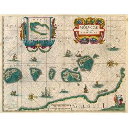
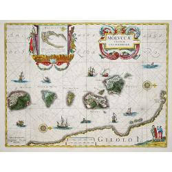
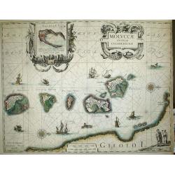
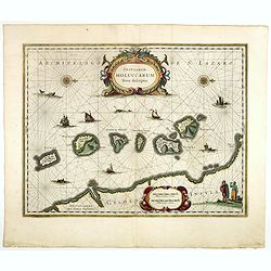
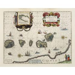
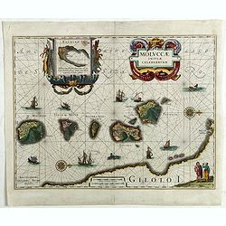
Moluccae Insulae Celeberrimae.
The map shows the islands of Ternate, Tidore, Mot and Makian. In the top right corner an inset map of the island of Bachian is shown. Latin text.
Date: Amsterdam, 1635
Selling price: ????
Please login to see price!
Sold in 2009
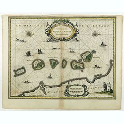
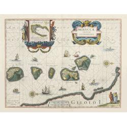
Moluccae Insulae Celeberrimi.
Willem Blaeu's very fine map of the Spice islands, with a detailed map of the Island of Bachian in a handsome border. Further embellished with a large title-cartouche, an...
Date: Amsterdam, ca 1635
Selling price: ????
Please login to see price!
Sold in 2019
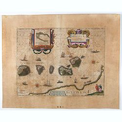
MOLUCCAE Insulae Celeberrimae.
The earliest full-scale and highly decorative map of the "Spice Islands". In addition to a sumptuous title cartouche, the map features an inset of the Island of...
Date: Amsterdam, 1635-1638
Selling price: ????
Please login to see price!
Sold
India quae Orientalis dicitur, et insulae adiacentes.
Extending from India to Japan and showing parts of Australia. It is indeed one of the first printed maps to show identifiable parts of Australia. It was not revised until...
Date: Amsterdam, 1638
Selling price: ????
Please login to see price!
Sold in 2010
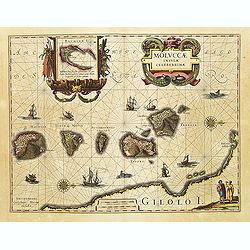
Moluccae Insulae Celeberrimae.
Showing the geographical features of the islands, and decorated with ships, sea monsters and a handsome cartouche. With an inset of Bachian island.One of the most appeali...
Date: Amsterdam, 1638
Selling price: ????
Please login to see price!
Sold in 2010
India quae Orientalis dicitur, et insulae adiacentes.
Extending from India to Japan and showing parts of Australia. It is indeed one of the first printed maps to show identifiable parts of Australia. It was not revised until...
Date: Amsterdam, c.1638
Selling price: ????
Please login to see price!
Sold in 2011
Exacta & accurata.. regionibus China, Cauchinchina, Camboja..
...the Far East and the Malay Archipelago are represented in such detail as was known only to the Portuguese at that time and had never before shown on a printed map. (S...
Date: Amsterdam, 1599-1638
Selling price: ????
Please login to see price!
Sold in 2018
Indiae Orientalis Nova Descriptio.
From "Atlas Novus, sive theatrum orbus terrarum." Amsterdam, 1639 A.D. French text to verso.The map shows area of south east Asia with their countries of Indone...
Date: Amsterdam, 1639
Selling price: ????
Please login to see price!
Sold in 2016
Moluccae Insulae Celeberrimae.
Nice map of the Moluccan Islands in the Indonesian Archipelago.Beautiful cartouches. Verso blanc.
Date: Amsterdam, c 1640
Selling price: ????
Please login to see price!
Sold
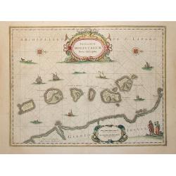
Insularum Moluccarum Nova descriptio.
Exquisite map of the famous Spice Islands based on the islands described by Jan Huyghen van Linschoten. This map was the first large scale map of the region and depicts t...
Date: Amsterdam, 1640
Selling price: ????
Please login to see price!
Sold
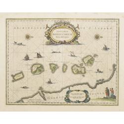
Insularum Moluccarum Nova descriptio.
The small spice islands off the west coast of the island of Halmahera in the eastern part of the archipelago. With an imposing title cartouche, together with finely drawn...
Date: Amsterdam, 1640
Selling price: ????
Please login to see price!
Sold in 2009
Insularum Moluccarum Nova descriptio.
Exquisite map of the famous Spice Islands based on the islands described by Jan Huyghen van Linschoten. This map was the first large scale map of the region and depicts t...
Date: Amsterdam, 1640
Selling price: ????
Please login to see price!
Sold in 2017
Moluccae Insulae Celeberrimae.
This plate was originally engraved in the 1620, and published as a loose-sheet by Jodocus Hondius II. At his death in August 1629 this map was, among 39 other copper plat...
Date: Amsterdam, 1640
Selling price: ????
Please login to see price!
Sold in 2017
Insularum Moluccarum Nova descriptio.
Exquisite map of the famous Spice Islands based on the islands described by Jan Huyghen van Linschoten.This map was the first large scale map of the region and depicts th...
Date: Amsterdam, 1640
Selling price: ????
Please login to see price!
Sold in 2020
Insularum Moluccarum Nova descriptio.
Exquisite map of the famous Spice Islands based on the islands described by Jan Huyghen van Linschoten.This map was the first large scale map of the region and depicts th...
Date: Amsterdam, 1640
Selling price: ????
Please login to see price!
Sold in 2018
Moluccae Insulae Celeberrimae.
This plate was originally engraved in the 1620, and published as a loose-sheet by Jodocus Hondius II. At his death in August 1629 this map was, among 39 other copper plat...
Date: Amsterdam, 1640
Selling price: ????
Please login to see price!
Sold in 2020
India quae Orientalis dicitur...
Map of South East Asia showing the area between India in the West and parts of Japan, the Marianas and New Guinea/Australia in the East. Copper engraving in original colo...
Date: Amsterdam, c. 1644
Selling price: ????
Please login to see price!
Sold in 2014
Indiae Orientalis nova descriptio.
An important map of South East Asia, noteworthy for being amongst the first maps to include any information on the discoveries made by the Dutch vessel Duyfkens in New Gu...
Date: Amsterdam 1645
Selling price: ????
Please login to see price!
Sold
Indiae Orientalis nova descriptio.
An important map of South East Asia, noteworthy for being amongst the first maps to include any information on the discoveries made by the Dutch vessel Duyfkens in New Gu...
Date: Amsterdam 1645
Selling price: ????
Please login to see price!
Sold
Insularum Moluccarum Nova descriptio - Amstelodami, Apud Ioannem Ianßonium.
Shows the islands Moluccas of Indonesia. Very decorative map.
Date: Amsterdam, 1645
Selling price: ????
Please login to see price!
Sold in 2013
Indiae Orientalis nova descriptio.
An important map of South East Asia, noteworthy for being amongst the first maps to include any information on the discoveries made by the Dutch vessel Duyfkens in New Gu...
Date: Amsterdam, 1645
Selling price: ????
Please login to see price!
Sold in 2021
Indiae Orientalis nova descriptio.
An important map of South East Asia, noteworthy for being amongst the first maps to include any information on the discoveries made by the Dutch vessel Duyfkens in New Gu...
Date: Amsterdam 1650
Selling price: ????
Please login to see price!
Sold
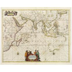
Mar di India.
This chart from Johannes Janssonius' sea-atlas 'De Water-Weereld' covers the area between the Cape of Good Hope and Japan.It owes its importance to the rendering of the c...
Date: Amsterdam 1650
Selling price: ????
Please login to see price!
Sold

Mar di India.
This chart from Johannes Janssonius' sea-atlas 'De Water-Weereld' covers the area between the Cape of Good Hope and Japan.It owes its importance to the rendering of the c...
Date: Amsterdam, 1650
Selling price: ????
Please login to see price!
Sold in 2008
India orientalis et insulae adiecentes.
Mathias Merian's fine and decorative reduction of Blaeu's map of South East Asia.
Date: Frankfurt, 1650
Selling price: ????
Please login to see price!
Sold in 2009
Mar di India.
This chart from Johannes Janssonius' sea-atlas 'De Water-Weereld' (the first European folio sea atlas) covers the area between the Cape of Good Hope and Japan.It owes its...
Date: Amsterdam, 1650
Selling price: ????
Please login to see price!
Sold in 2009
Moluccae Insulae Celeberrimae.
Showing the geographical features of the islands, and decorated with ships, rhumb lines, ships and sea monsters and a handsome cartouche. With an inset of Bachian island....
Date: Amsterdam, ca. 1650
Selling price: ????
Please login to see price!
Sold in 2017
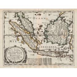
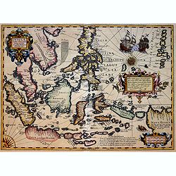
Les Isles de la Sonde. entre lesquelles sont Sumatra, Java, Borneo, &c.
A map covering Indonesia, from the first edition of the atlas L'Asie en plusieurs cartes nouvelles, et exactes & en divers traittés de Géographie, et d'Histoire.Nic...
Date: Paris, 1652
Selling price: ????
Please login to see price!
Sold in 2012
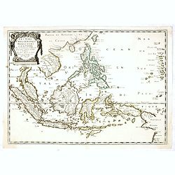
Les Isles Philippines Molucques et de la Sonde.
Sanson's important mid-seventeenth century map of the East Indies, covering modern Indonesia, the Philippines, Malaysia and parts of Southeast Asia and New Guinea. At a s...
Date: Paris, 1654
Selling price: ????
Please login to see price!
Sold in 2017
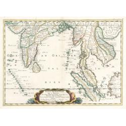
Partie meridionale de L'Inde En deux Presqu'Isles l'une deca et l'autre Gange
A superb example of Sanson's map of the Indian subcontinent and Southeast Asia. With the Dutch and English East India Companies being founded at the turn of the 17th maps...
Date: Paris, 1654
Selling price: ????
Please login to see price!
Sold in 2023
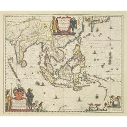
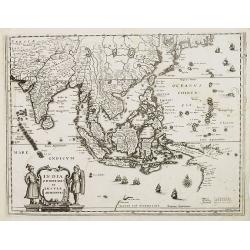
India Orientalis nec non Insularum Adiacentium Nova Descriptio.
This superb map of South East Asia presents a detailed image of the sphere of operations and Asian trading empire of the Dutch East India Company. The map extends from In...
Date: Amsterdam, 1656
Selling price: ????
Please login to see price!
Sold in 2009
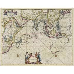
Mar di India.
This from Johannes Janssonius' important sea-atlas 'De Water-Weereld' covers the area between the Cape of Good Hope, Korea and Korea (INS: CORAI) and Japan.It owes its i...
Date: Amsterdam, 1657
Selling price: ????
Please login to see price!
Sold in 2011
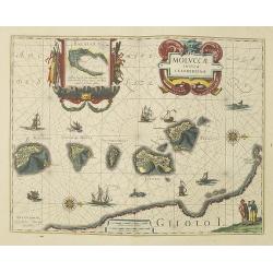
Moluccae Insulae Celeberrimae.
Showing the geographical features of the spice islands, and decorated with ships, sea monsters and a handsome cartouche. In addition to a sumptuous title cartouche, the m...
Date: Amsterdam, 1658
Selling price: ????
Please login to see price!
Sold
Moluccae Insulae Celeberrimae.
Showing the geographical features of the spice islands, and decorated with ships, sea monsters and a handsome cartouche. In addition to a sumptuous title cartouche, the m...
Date: Amsterdam, 1658
Selling price: ????
Please login to see price!
Sold
Moluccae Insulae Celeberrimae.
Showing the geographical features of the spice islands, and decorated with ships, sea monsters and a handsome cartouche. In addition to a sumptuous title cartouche, the m...
Date: Amsterdam, 1658
Selling price: ????
Please login to see price!
Sold in 2022
India Orientalis Nova.
Charming uncommon miniature map showing the northern two-thirds of Australia pre-discoveries by Captain Cook, but showing discoveries by Abel Tasman in 1642. The map show...
Date: Amsterdam, 1659
Selling price: ????
Please login to see price!
Sold in 2017
Insula BORNEO et occidentalis pars celibis cum adjacentibus Insulis.
An elegant map of Borneo. The map includes only coastal detail.The beautiful map is richly embellished with two fine cartouches featuring mermaids surrounding the scale o...
Date: Amsterdam 1660
Selling price: ????
Please login to see price!
Sold
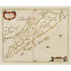
Sumatrae et insularum Locorumque nonnullorum circumiacentium
Fine chart depicting the Island of Sumatra and the southern coasts of Malaysia from Quedo to Johore. North is orientated to the left of the page. Singapore is probably id...
Date: Amsterdam 1660
Selling price: ????
Please login to see price!
Sold
Sumatrae et insularum Locorumque nonnullorum circumiacentium..
Fine chart depicting the Island of Sumatra and the southern coasts of Malaysia from Quedo to Johore.North is orientated to the left of the page.Singapore is probably iden...
Date: Amsterdam 1660
Selling price: ????
Please login to see price!
Sold
