Browse Listings in Asia
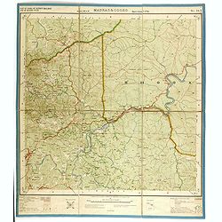
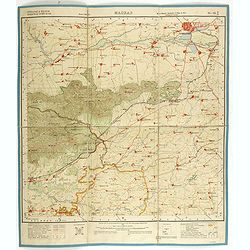
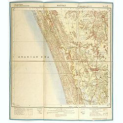
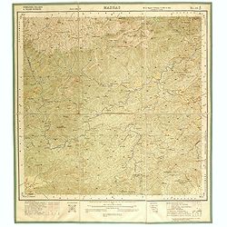
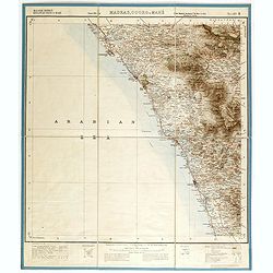
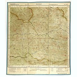
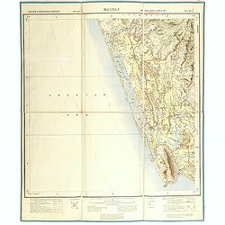
Part of district Malabar and of Mysore State. MADRAS NO 58 A1.
Very detailed "Survey of India" map made by trigonometric surveying techniques. Season 1912-1913 and published in 1914.This "Survey of India" map was ...
Date: Calcutta, Superintendent government printing, India, 1910
Selling price: ????
Please login to see price!
Sold in 2014
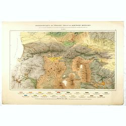
Geologische Karte des Nördlinchen Theiles des Armenischen Hochlandes . . .
Geological map of part of Armenia. More about geological maps [+]
Date: Winterthur, ca. 1910
Selling price: ????
Please login to see price!
Sold in 2016
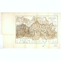
Sikkim and Bhutan wit parts of Adjacent countries. . .
Lithographed map by John Claude White of Sikkim and Bhutan showing Talung, Tongshyong and Passanram glaciers. The map was published in the Geographical Journal of 1910, t...
Date: London, 1910
Selling price: ????
Please login to see price!
Sold in 2017
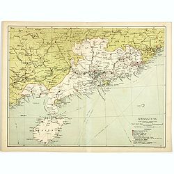
Kwangtung. (with Hong Kong)
Lithographed map of Kwangtung, with Hong Kong, Canton, Hainan, etc. In lower right corner a key and scale in English Miles and Kilometers.
Date: London, circa 1910
Selling price: ????
Please login to see price!
Sold in 2017
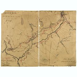
Chemin de fer du Yum-Nan. Boucle du Pei-ho ou Faux Namti entre Kilomètres 104 et 119 (7ème Lot).
Manuscript map of Boucle du Pei-Ho (Taku Forts) showing the river Pei-ho, along with the projected railway lines were to be built, including bridges, installations, villa...
Date: China ?, ca.1910
Selling price: ????
Please login to see price!
Sold in 2023
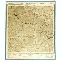
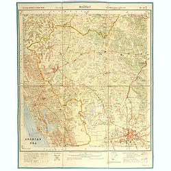
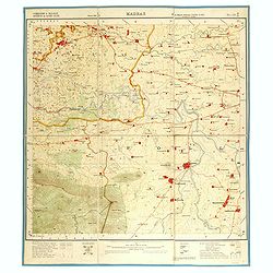
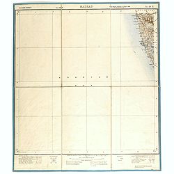
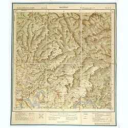
District Malabar & Padinalknad & Yedenalknad Tâluks. MADRAS & COORG NO 48 P12.
Very detailed "Survey of India" map made by trigonometric surveying techniques. Season 1912-1913 and published in 1914.This "Survey of India" map was ...
Date: Calcutta, Superintendent government printing, India, 1911
Selling price: ????
Please login to see price!
Sold in 2014
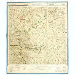
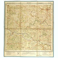
District Malabar &Kiggatnäd & Yedenalknad Tâluks. MADRAS & COORG NO 48 P16.
Very detailed "Survey of India" map made by trigonometric surveying techniques. Season 1912-1913 and published in 1914.This "Survey of India" map was ...
Date: Calcutta, Superintendent government printing, India, 1911
Selling price: ????
Please login to see price!
Sold in 2014
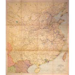
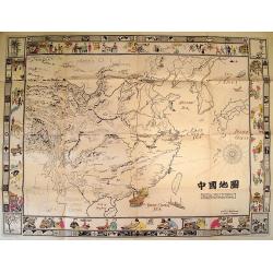
A Map of China Prepared for the China Inland Mission
Large, scarce map of China mounted on linen and folded into original red boards. The map was prepared by Stanford for the China Inland Mission, an interdenominational Pro...
Date: London, 1911
Selling price: ????
Please login to see price!
Sold in 2015
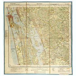
Coimbatore & Malabar districts & Cochin states. MADRAS NO 58 B-13
Very detailed "Survey of India" map made by trigonometric surveying techniques. Season 1909-1910 and published in 1912.This "Survey of India" map was ...
Date: Calcutta, Superintendent government printing, India, 1912
Selling price: ????
Please login to see price!
Sold in 2014
Malabar district & Cochin state. MADRAS NO 58 B-10
Very detailed "Survey of India" map made by trigonometric surveying techniques. Season 1909-1910 and published in 1912.This "Survey of India" map was ...
Date: Calcutta, Superintendent government printing, India, 1912
Selling price: ????
Please login to see price!
Sold in 2014
Malabar district & Cochin state. MADRAS NO 58 B-6
Very detailed "Survey of India" map made by trigonometric surveying techniques. Season 1909-1910 and published in 1912.This "Survey of India" map was ...
Date: Calcutta, Superintendent government printing, India, 1912
Selling price: ????
Please login to see price!
Sold in 2014
Coimbatore & Malabar districts. MADRAS NO 58 B-9
Very detailed "Survey of India" map made by trigonometric surveying techniques. Season 1909-1910 and published in 1912.This "Survey of India" map was ...
Date: Calcutta, Superintendent government printing, India, 1912
Selling price: ????
Please login to see price!
Sold in 2014
Malabar district & Cochin & Travancore States. MADRAS NO 58 B-3
Very detailed "Survey of India" map made by trigonometric surveying techniques. Season 1909-1911 and published in 1912.This "Survey of India" map was ...
Date: Calcutta, Superintendent government printing, India, 1912
Selling price: ????
Please login to see price!
Sold in 2014
Malabar district & Cochin State. MADRAS NO 58 B-2
Very detailed "Survey of India" map made by trigonometric surveying techniques. Season 1909-1910 and published in 1912.This "Survey of India" map was ...
Date: Calcutta, Superintendent government printing, India, 1912
Selling price: ????
Please login to see price!
Sold in 2014
Malabar district & cochin states. MADRAS NO 58 B1.
Very detailed "Survey of India" map made by trigonometric surveying techniques. Season 1912-1913 and published in 1914.This "Survey of India" map was ...
Date: Calcutta, Superintendent government printing, India, 1912
Selling price: ????
Please login to see price!
Sold in 2014
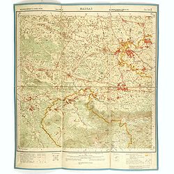
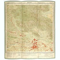
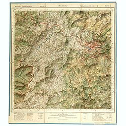
Combatore, Malabar & Nilgiri Districts. MADRAS NO 58 A12.
Very detailed "Survey of India" map made by trigonometric surveying techniques. Season 1912-1913 and published in 1914.This "Survey of India" map was ...
Date: Calcutta, Superintendent government printing, India, 1912
Selling price: ????
Please login to see price!
Sold in 2014
Coimbatore & Malabar Districts& cochin state. MADRAS NO 58 B14.
Very detailed "Survey of India" map made by trigonometric surveying techniques. Season 1912-1913 and published in 1914.This "Survey of India" map was ...
Date: Calcutta, Superintendent government printing, India, 1912
Selling price: ????
Please login to see price!
Sold in 2014
Coimbatore & Malabar districts. MADRAS NO 58 B-9.
Very detailed "Survey of India" map made by trigonometric surveying techniques. Season 1909-1910 and published in 1912.This "Survey of India" map was ...
Date: Calcutta, Superintendent government printing, India, 1912
Selling price: ????
Please login to see price!
Sold in 2015
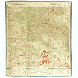
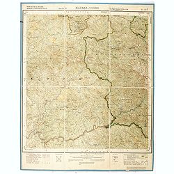
Malabar district & cochin & Travancore states. MADRAS NO 58 C45.
Very detailed "Survey of India" map made by trigonometric surveying techniques. Season 1912-1913 and published in 1914.This "Survey of India" map was ...
Date: Calcutta, Superintendent government printing, India, 1913
Selling price: ????
Please login to see price!
Sold in 2014
Malabar district, Kiggatnad Taluk & Mahé. MADRAS, COORG & MAHE NO 49 M.
Very detailed "Survey of India" map made by trigonometric surveying techniques. Season 1912-1913 and published in 1914.This "Survey of India" map was ...
Date: Calcutta, Superintendent government printing, India, 1913
Selling price: ????
Please login to see price!
Sold in 2014
Malabar district. MADRAS, COORG & MAHE NO 49 N.
Very detailed "Survey of India" map made by trigonometric surveying techniques. Season 1912-1913 and published in 1914.This "Survey of India" map was ...
Date: Calcutta, Superintendent government printing, India, 1913
Selling price: ????
Please login to see price!
Sold in 2014
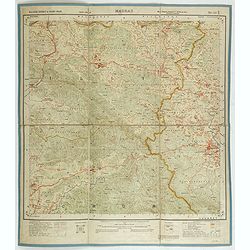
Malabar & Nilgiri Districts. MADRAS NO 58 A11.
Very detailed "Survey of India" map made by trigonometric surveying techniques. Season 1912-1913 and published in 1914.This "Survey of India" map was ...
Date: Calcutta, Superintendent government printing, India, 1913
Selling price: ????
Please login to see price!
Sold in 2014
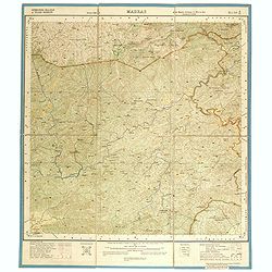
South Kanara & Malabar Districts & Pädinalknäd Täluk. MADRAS, COORG & MAHE NO 48 P7.
Very detailed "Survey of India" map made by trigonometric surveying techniques. Season 1912-1913 and published in 1914.This "Survey of India" map was ...
Date: Calcutta, Superintendent government printing, India, 1913
Selling price: ????
Please login to see price!
Sold in 2014
Malabar district & Cochin & Travancore states. MADRAS NO 58 B11
Very detailed "Survey of India" map made by trigonometric surveying techniques. Season 1912-1913 and published in 1913.This "Survey of India" map was ...
Date: Calcutta, Superintendent government printing, India, 1913
Selling price: ????
Please login to see price!
Sold in 2014
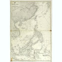
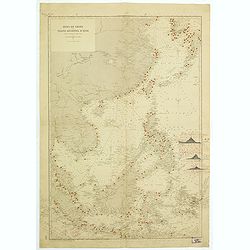
China sea compiled from the latest government surveys 1886.
Detailed sea chart of the "China Sea", first published by the British Admiralty in 1886, with correction to 1897 and small variations to 1913.Covering from 7° ...
Date: London 1886 updated to 1897/1913
Selling price: ????
Please login to see price!
Sold in 2018
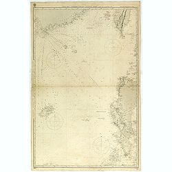
China Sea Northen portion - Eastern sheetCompiled from the latest Surveys 1881
Huge sailing chart showing the China Sea covering southeastern China in the vicinity of Hong Kong and Guangdong Province, southern Taiwan, and the northern Philippines (L...
Date: London 1881 updated to 1897/1913
Selling price: ????
Please login to see price!
Sold in 2018
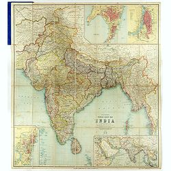
Thacker's Reduced Survey Map of India.
Thacker's reduced Survey Map of India prepared by John Bartholomew and published n Calcutta by Thacker, Spink, & Co. And W. Thacker & Co. in London in 1914.This e...
Date: Calcutta: Thacker, Spink, & Co./ London : W. Thacker and Co., 1914
Malabar & South Kanara districts. MADRAS NO 48 P 4
Very detailed "Survey of India" map made by trigonometric surveying techniques. Season 1912-1913 and published in 1914.This "Survey of India" map was ...
Date: Calcutta, Superintendent government printing, India, 1914
Selling price: ????
Please login to see price!
Sold in 2014
Hotel refreshment and dining car services.
Advertising leaflet for 3 hotels along the Chosen Railway stations of Fusan, Shingishu and Ghosen Hotel in Seoul. Among an impression of the dining car restaurant.On vers...
Date: Korea, 1914
Selling price: ????
Please login to see price!
Sold in 2016

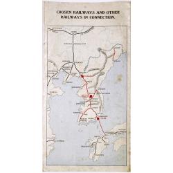
Map of Chosen (Korea)
A more than 100 years old publicity and time table for foreigners published by Chosen Railways for traveling in Korea.On one side a map of Korea (480 x 300mm.), with inse...
Date: Korea, 1914
Selling price: ????
Please login to see price!
Sold in 2017
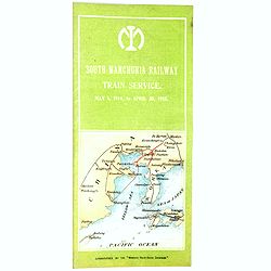
South Manchura Railway Train Service May 1 to April 30, 1915.
A 100 year's old Time Table of the South Manchuria Railway Train Service.
Date: ManshuNichi-Shimbun, 1915
Selling price: ????
Please login to see price!
Sold in 2017
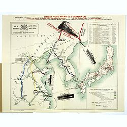
Map of Japan, Korea, Manchuria North China published by the International Sleeping Car Co.
> A more than 100 years old folding publicity map showing a map of Japan, Korea and Eastern China. The map shows pictorial representations of three cruise ships, a tr...
Date: Yokohama, Japan Gazette Press, 1915
Selling price: ????
Please login to see price!
Sold in 2018
![Manila the perl of the Orient. The Philippines Land of Palm and Pine. Guide book to the intending visitor [with several photos and 3 plans of Manila]](/uploads/cache/48357-250x250.jpg)
Manila the perl of the Orient. The Philippines Land of Palm and Pine. Guide book to the intending visitor [with several photos and 3 plans of Manila]
Charming 1915 Guide book tothe Philippines with several photos. Published by the "Manila merchants' association". With charming cover illustrations by T.Gaudin...
Date: Manilla, 1915
Selling price: ????
Please login to see price!
Sold in 2022
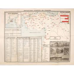
Instruction publique en Turquie.
Very rare separately published map of Turkey. In lower right insets of photo's of different schools, libraries and high schools in Istanbul. In upper left corner an inset...
Date: Societe anonyme de Papeterie et d'Imprimerie, Constantinople, 1919
Selling price: ????
Please login to see price!
Sold in 2016
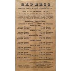
Express - Hongkong, Canton & Macao Steamboat Co., Ltd.
A very rare broadside: Express Hongkong, Canton & Macao Steamboat Co., Ltd. and China Navigation Company, Limited. With departure times of the boats. Printed in Hongk...
Date: Hongkong, 1919
Selling price: ????
Please login to see price!
Sold in 2016
UNTITLED
Rare map of three Roman Catholic apostolic vicariates in Korea. The first of Korea was established in 1831 from the Diocese of Peking. In 1911, it was renamed the Apostol...
Date: c. 1920
Selling price: ????
Please login to see price!
Sold in 2010
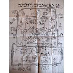
Welfare Map of Peiping.
Charming piece of early 20th century ephemera. This appeal of this tourist map of Beijing’s Tartar and Chinese cities is enhanced by the numerous cartoon vignettes foun...
Date: Beijing, c. 1920
Selling price: ????
Please login to see price!
Sold in 2010
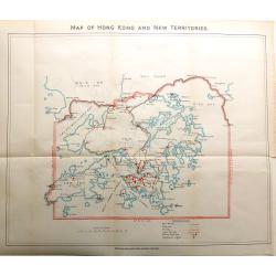
Map of Hong Kong and New Territories
An interesting map of Hong Kong and its Islands, showing main roads and railways, plus police stations and navigation lights.
Date: London, 1920
Selling price: ????
Please login to see price!
Sold in 2016
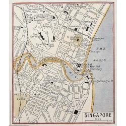
Singapore.
Despite its small size it shows the city in great detail, with many street names, buildings, and places, etc. Includes the Raffles Hotel, the railway station, exchange, p...
Date: London, ca. 1920
Selling price: ????
Please login to see price!
Sold in 2016
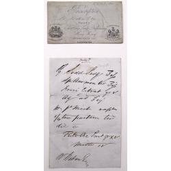
Prescription prepared at the Hong Kong Dispensary.
Unique old prescription in two parts by the Hong Kong Dispensary with handwritten text and instruction. The prescription with the nice seals. No written date given, but p...
Date: Hongkong, probably ca.1920
Selling price: ????
Please login to see price!
Sold in 2016
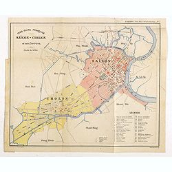
Indo-Chine Française Saïgon - Cholon et ses Environs
Charming plan of Saïgon at a scale of 1:40.000. Vietnam was a French colony from 1862 to 1954.Prepared by R.Brissaud and published in P.Alinot, Petit Atlas de la Cochinc...
Date: Saigon, Librairie Brunet. c.1920
Selling price: ????
Please login to see price!
Sold in 2020
![Indonesia & Malaysia [epherma].](/uploads/cache/81165-250x250.jpg)
Indonesia & Malaysia [epherma].
Three early papers of Hotel des Indes, British India Steamer Baggage label to Yangon, and a hotel in Penang.Hotel des Indes was one of the oldest and most prestigious hot...
Date: Anon, ca. 1920
Selling price: ????
Please login to see price!
Sold in 2018
Carte de l''Indochine, feuille n°13: Bang-Kok.
Large scale map (1:500,000) centered on Bang Kok. Prepared by Lieutenant Colonel Dubuisson, head of the "Service Géographique de l'Indochine". With a color key...
Date: Hanoï, 1923
Selling price: ????
Please login to see price!
Sold in 2013
Burma
Curious large-scale map of Amherst & Thaton districts in Burma. Shows the area around Kamkareik with many place names, rivers, topographical features, etc. The Legend...
Date: 1925
Selling price: ????
Please login to see price!
Sold in 2012
Tetsudo kyoso Sugoroku [Railway Race Sugoroku)
A scarce Japan map produced ca. 1925 (Taisho 14) board for the Japanese game known as 'sugoroku'. The board depicts the islands of Japan oriented in a northwesterly direc...
Date: Sogoroku-taisho14-1925
Selling price: ????
Please login to see price!
Sold in 2017
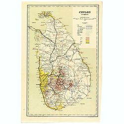
Ceylon.
A uncommon issue of this detailed map of Ceylon. Notes roads, railways, towns, rivers, lakes, and a host of other topographical features. Scale of 24 miles to an inch. Th...
Date: Colombo, 1925
Selling price: ????
Please login to see price!
Sold in 2019
Ceylon.
A uncommon issue of this detailed map of Ceylon. The map covers the entire island and is color coded according to provinces. Notes roads, railways, towns, rivers, lakes, ...
Date: Colombo, 1925
Selling price: ????
Please login to see price!
Sold in 2022
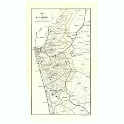
City of Colombo.
A uncommon issue of this detailed map of Colombo.The Department of Survey of Sri Lanka (also known as the Department of the Surveyor General) is a non-ministerial governm...
Date: Colombo, 1925
Selling price: ????
Please login to see price!
Sold in 2019
Côte Est d'Asie. Iles et Mers du Japon Mer Jaune.
Large French sea chart featuring the northern part of the Pacific Ocean and the Yellow Sea with Korea and Quelpaert Island, Japan and the coasts of Manchuria, and China t...
Date: France, 1906-1925
Selling price: ????
Please login to see price!
Sold in 2020
Côte Est de Chine. Rivière de Wusung. Port de Shangaï.
Important French map featuring the harbour of Shanghai during the Chinese Revolution and the Civil War, and representing the French, English and American concessions. Ann...
Date: France, 1905-1925
Selling price: ????
Please login to see price!
Sold in 2018
Sketch map of the Glaciers of Kangchenjunga.
This important 'Sketch-map of the Glaciers of Kangchenjunga’, by E.J. Garwood was prepared on Freshfield's expedition of 1899, a red line in red pen and ink is showing ...
Date: London, Edward Arnold, 1926
Selling price: ????
Please login to see price!
Sold in 2017
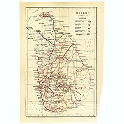
Ceylon showing annual average rainfall up to 1926 inclusive.
A uncommon issue of this detailed map of Ceylon showing the annual average rainfall in a scale of 24 miles to an inch. The Department of Survey of Sri Lanka (also known a...
Date: Colombo, 1926
Selling price: ????
Please login to see price!
Sold in 2022
Philippine Islands
John Bach map of the Philippines published in Manila. Provinces are illustrated in different colors. Operating railroads on Luzon, Cebu, and Panay appear as thick black w...
Date: Manilla, 1926
Selling price: ????
Please login to see price!
Sold in 2021
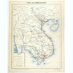
Voies de communication.
The map is published by the Service geographique de l'Indochine.The Frenchman Jules-Léon Dutreuil de Rhins produced at the end of the 19th century a general map of Indoc...
Date: Hanoi, November 1927
Selling price: ????
Please login to see price!
Sold in 2016
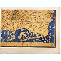
Single sheet from Tabula Rogeriana world map with the Far East section.
Single sheet from a 6-sheet version of the [TABULA ROGERIANA] [NUZHAT AL-MUSHTĀQ FI'KHTIRĀQ AL-ĀFĀQ - THE BOOK OF PLEASANT JOURNEYS INTO FARAWAY LANDS]., covering the...
Date: 1151 BUT Suttgart, Konrad Miller, 1928
Selling price: ????
Please login to see price!
Sold in 2017
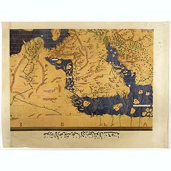
Single sheet from Tabula Rogeriana world map with Arabian Peninsular section.
Separate single sheet (of 6) with the Arabian Peninsula and Egypt section of the [TABULA ROGERIANA] [NUZHAT AL-MUSHTĀQ FI'KHTIRĀQ AL-ĀFĀQ - THE BOOK OF PLEASANT JOURN...
Date: 1151 BUT Suttgart, Konrad Miller, 1928
Selling price: ????
Please login to see price!
Sold in 2017
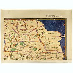
Single sheet from Tabula Rogeriana world map with Siberia and Tartary section.
Separate single sheet (of 6) with the Siberia and Tartary section of the [TABULA ROGERIANA] [NUZHAT AL-MUSHTĀQ FI'KHTIRĀQ AL-ĀFĀQ - THE BOOK OF PLEASANT JOURNEYS INTO...
Date: 1151 BUT Suttgart, Konrad Miller, 1928
Selling price: ????
Please login to see price!
Sold in 2017
Mer de Chine et Grand Archipel d'Asie.
Large French sea chart featuring the Philippines, the coasts of China, Malaysia and Indonesia.On the back of the map, inscriptions in pencil indicate that the map figures...
Date: France, 1897-1929
Selling price: ????
Please login to see price!
Sold in 2018
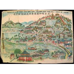
The Map of Yu Ho Yuan Won Shou Shan Including Kuen Ming Hou Near of Peking.
Charming ephemeral map of Peking's Summer Palace (Yihe Yuan) created during China's Republican Period. The map features Longevity Hill and its numerous halls and pavilion...
Date: Beijing, c. 1930
Selling price: ????
Please login to see price!
Sold
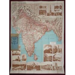
Tourist map of India, Indian State Railways.
An attractive large folding full color pictorial tourist map of India, showing Tibet to the north, Burma to the east, Ceylon in the south. With many photographic illustra...
Date: London, 1930
Selling price: ????
Please login to see price!
Sold in 2016
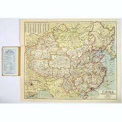
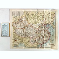
China Manchuria and Mongolia.
A large and concise map of China, Manchuria and neighboring Mongolia. With its original biscuit colored paper wrappers, and publisher's advertisements. Lower left has ins...
Date: London, ca. 1930
Selling price: ????
Please login to see price!
Sold in 2017
China Manchuria and Mongolia.
A large and concise map of China, Manchuria and neighboring Mongolia. With its original biscuit colored paper wrappers, and publisher's advertisements. Lower left has ins...
Date: London, ca. 1930
Selling price: ????
Please login to see price!
Sold in 2019
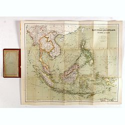
East Indies. (Malay, or East Indian Archipelago with Burma & Siam)
Folding map of the East Indies, Indonesia, Indochina, Thailand, Burma, the Malay Peninsula, Borneo, the Philippines, Sumatra, Java, Celebes.Sifton, Praed & Co., Ltd. ...
Date: London, ca. 1930
Selling price: ????
Please login to see price!
Sold in 2017
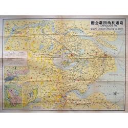
A COMPREHENSIVE MAP OF NANKING-SHANGHAI-HANGCHOW AND NINGPO.
A large litho map of the Chinese region of Shanghai and the important cities to the west of Nanking, Hangchow, and Ningpo.
Date: Anon, ca. 1930
Selling price: ????
Please login to see price!
Sold in 2018
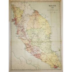
Malaya 1931
An interesting map of Malaysia with Singapore, dated 1931, and it’s Islands, showing main roads and railways. The States are defined by color.Published under the Direct...
Date: London, 1931
Selling price: ????
Please login to see price!
Sold in 2016
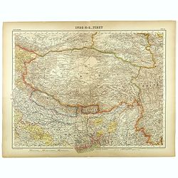
Inde N-E., Tibet.
Very detailed map of Tibet, with a color code to British, Chinese and Indo-French possessions. From "Atlas Universel" by Bagge and D. Aïtoff.
Date: Paris, 1931
Selling price: ????
Please login to see price!
Sold in 2021
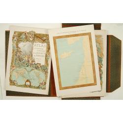
Atlas de géographie economique de la Paléstine.
Impressive atlas including historical, geographical and economical maps of Israel from the earliest time. The 135 maps are printed in color. One of the 3 title pages with...
Date: Paris 1932
Selling price: ????
Please login to see price!
Sold
Picture Map of China.
Splendid Art Deco map of China designed to interest and inform children about the country of China. The map is intended to be colored, with the four seasons represented i...
Date: New York, 1932
Selling price: ????
Please login to see price!
Sold in 2010
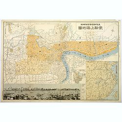
Plan of Shanghai.
A rare plan in Japanese of the Chinese super city of Shanghai, but with individual street names in English. The focus is on central Shanghai and the Bund, the key financi...
Date: Shanghai, 1932
Selling price: ????
Please login to see price!
Sold in 2017
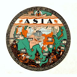
Chart of Knowledge.
This is a rare 1932 double-sided S. G. Bocholtz and Chart of Knowledge spinning wheel map of Asia and Europe. The map of the Asia depicts from Arabia to Japan and from th...
Date: Boston, 1932
Selling price: ????
Please login to see price!
Sold in 2020
Korea.
Decorative color printed map of Korea in Manga style. From Nihon Manshu Panorama Chiri (Panoramic Geography of Japan and Manchuria) by Ryushiro Kato (map design and text)...
Date: Dai Nihon Yubenkai Kodan Sha, Japan, 1933
Selling price: ????
Please login to see price!
Sold in 2017
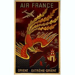
Near East - Far East.
AIR FRANCE poster promoting the airline's routes to the far east in the immediate post-war period. This is the full size version of Lucien Boucher's "phoenix" d...
Date: Imprimerie Perceval Paris, ca. 1933
Selling price: ????
Please login to see price!
Sold in 2019
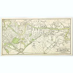
Plan of the Concessions Tientsin.
This plan was drawn for Crow's "Handbook for China" in 1933. It depicts a city map or plan of the foreign concessions in Tianjin (Tientsin), China. The map is b...
Date: Hong Kong, Shanghai, Singapore, 1933
Selling price: ????
Please login to see price!
Sold in 2020
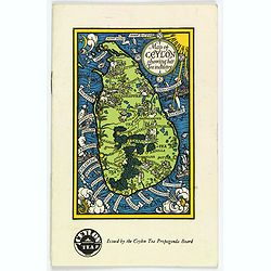
Map of Ceylon showing her Tea Industry.
A delightful little brochure highlighting the Ceylonese tea industry, issued by the Ceylon Tea Propaganda Board in the mid 1930s. It features a lovely map of the island o...
Date: Ceylon, ca 1934
Selling price: ????
Please login to see price!
Sold in 2020
![[Original Chinese advertising poster for Donggong Business School]](/uploads/cache/45081-250x250.jpg)
[Original Chinese advertising poster for Donggong Business School]
This poster, an advertisement from the 1930s for Donggong Business School depicts a pretty woman holding a beautiful fan and wearing jewelry. It shows the rise of Western...
Date: Shanghai, 1934
Selling price: ????
Please login to see price!
Sold in 2020
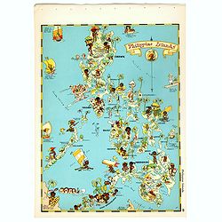
Philippines Islands.
Pictorial map of Philippines Islands, from the famous illustrator, Ruth Taylor White and published in "Our USA: A Gay Geography".Ruth Taylor White was among the...
Date: Boston, Little, Brown and Company, 1935
Selling price: ????
Please login to see price!
Sold in 2017
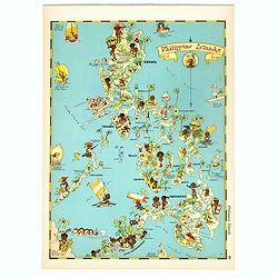
Philippines Islands.
Pictorial map of Philippines Islands, from the famous illustrator, Ruth Taylor White and published in "Our USA: A Gay Geography".Ruth Taylor White was among the...
Date: Boston, Little, Brown and Company, 1935
Selling price: ????
Please login to see price!
Sold in 2018
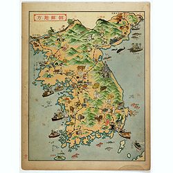
![Chousen Annai [Guide to Korea].](/uploads/cache/99672-250x250.jpg)
Chousen Annai [Guide to Korea].
6-panel tourist brochure featuring a lovely full-color bird’s-eye view of the Korean peninsula supplemented by copious text in Japanese and Korean about the country. Th...
Date: Tokyo, 1937
Selling price: ????
Please login to see price!
Sold in 2010