Sign In or Sign Up
Sign In or Sign Up
Subscribe to be notified if similar examples become available.
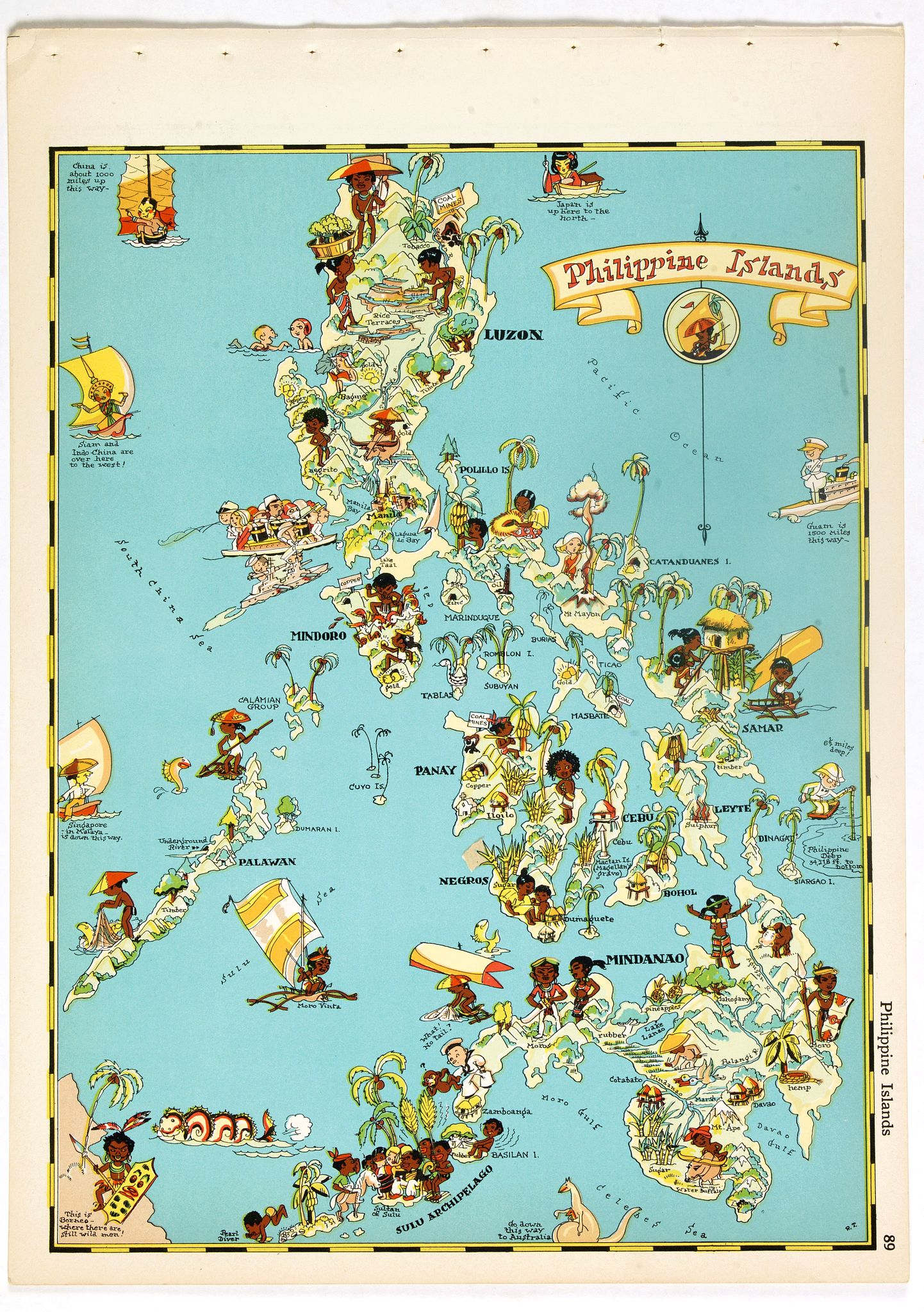
1935 TAYLOR WHITE, R. - Philippines Islands.
Philippines Islands. |
||||||||||||||||||||
|
||||||||||||||||||||
|
|
||||||||||||||||||||
|
Selling price: $ Please login to see price!
Sold in 2017 Missed this item! Add your name to our mailing list and be the first to get notified about our newly added listings. . |
My Collection +
Add this or any of your favorite items in one place. If you want to save the items permanently, you have to sign in or create an account first.   Add/Remove
 |
|||||||||||||||||||



Description
Pictorial map of Philippines Islands, from the famous illustrator, Ruth Taylor White and published in "Our USA: A Gay Geography".
Ruth Taylor White was among the most prolific makers of pictographic maps. Her whimsical style combines her artistic skills with local color and flavour, making her maps among the most collected pictographic maps.
Born in 1899, Taylor and her family, like many, headed persistently west in the late 19th century, moving from East Coast to West in the span of about 20 years and finally settling in California.
In the Spring of 1930, she left the kids at home in California and spent five weeks in Hawaii. Her trip was likely prompted by a commission from the Hawaii Tourist Bureau to draw the maps of the Hawaiian islands.
Our USA: A Gay Geography, published in 1935, was an atlas filled with whimsical and charming maps of all the states in the union, as well as American territories. The New York Times said in their review, ‘Any one who remembers his childhood efforts to visualize Kentucky as something more than the green spot on the map, or New York as the pink State, will appreciate this volume. Brilliantly colored pictorial maps of the same order which have been amusing adults for the past decade show the United States and their Territories as active, picturesque entities.’ (NYT, 17 Nov 1935). This book is very tough to find these days, even in libraries.
More about Ruth Taylor White and more about Pictorial Maps [+] [+]
Ruth Taylor-White (1899
Born in 1899, Ruth Taylor and her family, like many, headed persistently west in the late 19th century, moving from East Coast to West in the span of about 20 years and finally settling in California. According to the 1920 US Census, Taylor seemed to be settling into a pretty normal life--she was married to Leonard White and living in Phoenix, Arizona. Leonard was a life insurance salesman. Two kids followed, and so did divorce. With limited information, it’s easy to fill in the gaps and imagine a disastrous mismatch of temperaments, but all we know is that Ruth and her children moved to California and she began working as an illustrator. Ruth’s artistic training is unclear, but her family proved to be very important in her future work. Several of her early jobs were linked to her brother, Frank J. Taylor (1894-1972). Frank was a journalist and writer, served in World War I, and attended Stanford University. That school connection probably helped Ruth earn one of her early commissions, the cover of the November 1927 The Stanford Illustrated Review.Her detailed style brings humorous life to the crowd attending a football game. Ruth and her brother moved in an artistic and adventurous circle in the San Francisco area and the siblings shared an interest in the majestic nature found in the country's national parks. Frank was married to Katherine Ames, who was also an author. Like Frank, Ames was interested in nature and travel and she wrote books on nearby Yosemite National Park. In 1939, at the age of 40, she was in Japan (she did a map of the Philippines that may date from that trip) and as political tensions increased in Asia, she wisely returned home to the San Francisco area. That year, she rendered a cartograph of Treasure Island, the site of the Golden Gate International Exposition, a copy of which can be found at Beinecke Library at Yale. Remarkably, during World War II, Ruth kept up her international wandering. The end of the war found her in Calcutta, India, and by September 1945 she arrived back in New York, headed to her brother’s home in Los Altos, California. The wine map of California below is the only work I've found of hers in the post-war years.
FAQ - Guarantee - Shipping
This item is available for immediate purchase when a "Add to Cart" or "Inquire Now" button is shown.
Items are sold in the EU margin scheme
Payments are accepted in Euros or US Dollars.
Authenticity Guarantee
 We provide professional descriptions, condition report (based on 45 years experience in the map business)
Paulus Swaen warrants the authenticity of our items and a certificate of authenticity is provided for each acquired lot.
Condition and Coloring
We indicate the condition of each item and use our unnique HiBCoR grading system in which four key items determine a map's value: Historical Importance, Beauty, Condition/Coloring and Rarity.
Color Key
We offer many maps in their original black and white condition. We do not systematically color-up maps to make them more sellable to the general public or buyer.
Copper engraved or wood block maps are always hand colored. Maps were initially colored for aesthetic reasons and to improve readability. Nowadays, it is becoming a challenge to find maps in their original colors and are therefor more valuable.
We use the following color keys in our catalog:
Original colors; mean that the colors have been applied around the time the map was issued.
Original o/l colors; means the map has only the borders colored at the time of publication.
Colored; If the colors are applied recently or at the end of the 20th century.
Read more about coloring of maps [+]
Shipping fee
A flat shipping fee of $ 30 is added to each shipment by DHL within Europe and North America. This covers : International Priority shipping, Packing and Insurance (up to the invoice amount).
Shipments to Asia are $ 40 and rest of the world $50
We charge only one shipping fee when you have been successful on multiple items or when you want to combine gallery and auction purchases.
Read more about invoicing and shipping
FAQ
Please have a look for more information about buying in the BuyNow gallery
Many answers are likely to find in the general help section.
My Collection+

With My Collection+ you can collect all your favorite items in one place. It is free, and anyone can create his or her virtual collection.
Unless you are logged in, the item is only saved for this session. You have to be registed and logged-in if you want to save this item permanently to My Collection+. Read More[+]
Register here, it is free and you do not need a credit card.
Add this item to My Collection+ or click the following link to see My Collection+.
|
Digital Image Download Paulus Swaen maintains an archive of most of our high-resolution rare maps, prints, posters and medieval manuscript scans. We make them freely available for download and study. Read more about free image download |
Click the image for a free small image download. |
YOUR RIGHT TO CANCEL THE PURCHASE OF A LOT
In accordance with the EU Consumer Rights Directive and habitually reside in the European Union you have the right to cancel the contract for the purchase of a lot, without giving any reason.
The cancellation period will expire 14 calendar days from the day after the date on which you or a third party (other than the carrier and indicated by you) acquires, physical possession of the lot. To exercise the right to cancel you must inform Paulus Swaen Inc, of your decision to cancel this contract by a clear statement (e.g. a letter sent by post, or e-mail.
To meet the cancellation deadline, it is sufficient for you to send your communication concerning your exercise of the right to cancel before the cancellation period has expired.
