Browse Listings in Asia
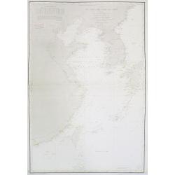
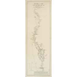
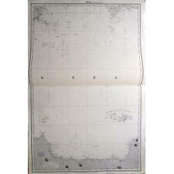
Carte de cotes orientales de Chine . . .
Chart of the China Sea, including Korea, Taiwan, and Kyushu island with lighthouse colored in red dots with yellow.The chart is showing towns, banks, isles, and soundings...
Date: Paris, 1842, updated 1877
Selling price: ????
Please login to see price!
Sold in 2009
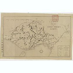
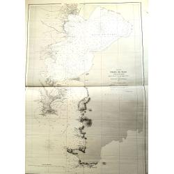
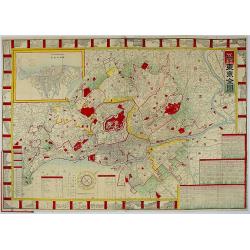
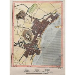
(Plan of Hiogo Treaty Limits)
Map of the new prefecture with Japanese and English descriptions. In lower right an key to "Position of Government Office, boundaries, road and railways. On January ...
Date: Meiji 10 = 1877
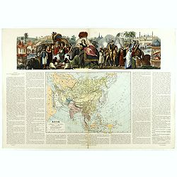
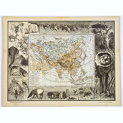
Asia dibujado grabado . . .
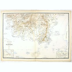
Very attractive large map of Asia with stunning panorama at top of elephants, horses and Asian horsemen including Moses in basket. A rare and decorative map. From "A...
Date: Madrid, 1877
Selling price: ????
Please login to see price!
Sold in 2019
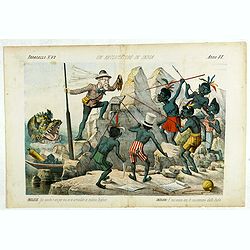
Un Reclutatore in India. Papagallo No. 42. Anno VI.
British in India. Design by Augusto Grossi. Taken from the Italian satirical newspaper Il Papagallo, a satirical magazine founded in January 1873 by Augusto Grossi (1835-...
Date: Bologne, 1878
Selling price: ????
Please login to see price!
Sold in 2019
Royaume de Siam - Cours du Fleuve Me - Nam..
Detailed missionary map illustrating the course of the Menam [Chao Phraya] river in today Thailand. With short legend in the lower left corner.Engraved in stone by R. Hau...
Date: Paris 1878 - 1879
Selling price: ????
Please login to see price!
Sold
Unusual Chart Of the Tokyo Yokohama Bay.
"Golfe de Yedo" le sud du Japon" d'aprés l'amirauté Britannique. 1872 corrections in 1876-78-79. Dépôt général de la marine. 1 x tearing paper off ma...
Date: Paris, 1879
Selling price: ????
Please login to see price!
Sold in 2021
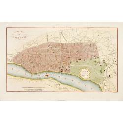
Plan de Calcutta.
Detailed plan of Calcutta, engraved by F. Dien and published in "Voyage aux Indes Orientales" de Charles Belanger.
Date: Paris, c.1880
Selling price: ????
Please login to see price!
Sold in 2015
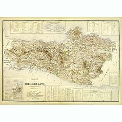
Kaart van midden Java. (tweede militaire afdeling)
Large map of central Java.
Date: The Hague, c. 1880
Selling price: ????
Please login to see price!
Sold in 2012
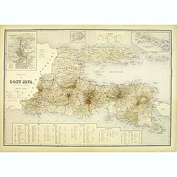
Kaart van oost Java. (derde militaire afdeling)
Large map of east Java.
Date: The Hague, c. 1880
Selling price: ????
Please login to see price!
Sold in 2012
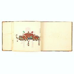
Chinese export album with 12 drawings.
Chinese export painting album with 12 drawings.
Date: Peking, 1880
Selling price: ????
Please login to see price!
Sold in 2016
Ju Hachi Shiryaku - Summaries of the 18 eras.
A wonderful atlas of Chinese maps, showing the geographic extent of various Chinese dynasties. 10 double page woodblock maps of China. Meiji 12 (1880) the text is in Japa...
Date: 1880
Selling price: ????
Please login to see price!
Sold in 2016
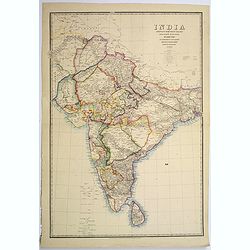
India shewing the post roads and dawk stations by James Wyld, geographer to the Queen and H.R.H. Prince Albert.
A large, decorative post road map also showing Indian railways. A color key is showing British possessions, subsidiary states, and protected and independent areas. Scale ...
Date: London, ca. 1880
Selling price: ????
Please login to see price!
Sold in 2017
Asien.
An unusual and decorative late Victorian xylographic map of Asia, by the German publisher Otto Spamer. The map itself is surrounded by uncolored woodcut engravings of the...
Date: Leipzig, ca. 1880
Selling price: ????
Please login to see price!
Sold in 2017
![[142 Indian Mica paintings.]](/uploads/cache/42949-250x250.jpg)
[142 Indian Mica paintings.]
One hundred and forty-two Mica Paintings of castes, people of India, trades-people, musicians, snake charmers.The majority of these paintings were produced in standard se...
Date: India, 1850 to ca.1880
Selling price: ????
Please login to see price!
Sold in 2019
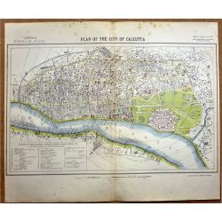
Plan of the City of Calcutta.
A highly detailed late -19th century plan of the city of Calcutta. It depicts the entire city in remarkable detail, noting individual streets, important public buildings,...
Date: London, 1881
Selling price: ????
Please login to see price!
Sold in 2020
A set of Twelve maps of India.
>A set of 12 highly detailed and beautifully colored maps of India at the time of the British Raj. The maps show in high detail; Railways existing and under constructi...
Date: London, 1881
Selling price: ????
Please login to see price!
Sold in 2019
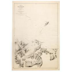
Carte de la Mer de Chine. . . N° 3002.
Sea chart depicting the China Sea prepared by the French Ingenieur L.Manen. The Chart is updated for the year 1882, and must have served the French during the Sino-French...
Date: Paris, 1871 updated to September 1882
Selling price: ????
Please login to see price!
Sold in 2009
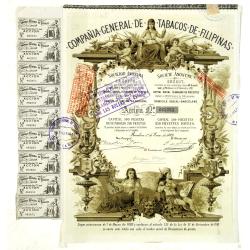
(Certificate) Accion ordinarias de 500 Pesetas.
Beautifully engraved certificate from the Compania General De Tabacos De Filipinas issued in 1882. This historic document has an ornate border with a vignette of allegori...
Date: Barcelona, 1882
Selling price: ????
Please login to see price!
Sold in 2012
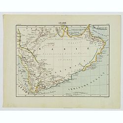
Arabie Zuidelijk.
A nice small Dutch map of southern Arabia in the late 19th century. With plenty of coastal detail, the interior was yet to be explored and recorded. The map shows Mecca, ...
Date: Amsterdam, 1882
Selling price: ????
Please login to see price!
Sold in 2020
The Chinese Empire Compiled from Native and Foreign Authorities.
Extremely detailed map of China and Korea with inset of Hong Kong & the Pearl River Delta and Amoy. Published by Charles Scribner's Sons.
Date: New York, 1883
Selling price: ????
Please login to see price!
Sold in 2012
Hyouchuu Hasshiryaku Kouhon - Summaries of the 18 Histories, Volume 1
A larger sized, beautiful atlas of Chinese maps, showing the geographic extent of various Chinese dynasties. 10 double page woodblock maps of China. Meiji 16 (1884) text ...
Date: 1884
Selling price: ????
Please login to see price!
Sold in 2016
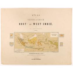
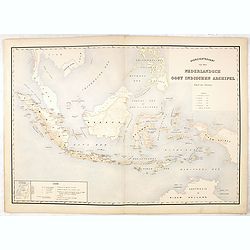
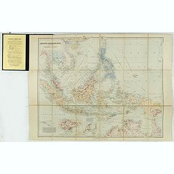
Overzichtskaart van den Nederlandsch oost Indischen Archipel.
Very detailed map of Indonesia, taken from "Atlas van Nederlandsch Oost- en West-Indie," prepared by a doctor I. Dornseiffen, and published by Seyffardt's Boekh...
Date: Amsterdam, Seyffardt, 1884
Selling price: ????
Please login to see price!
Sold in 2025
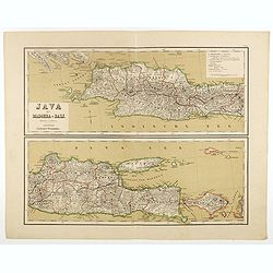
Java met Madoera en Bali. Schaal van 1:1750000.
A very detailed map of Java is divided in two parts, taken from "Atlas van Nederlandsch Oost- en West-Indie," prepared by a doctor I. Dornseiffen, and published...
Date: Amsterdam, Seyffardt, 1884
Selling price: ????
Please login to see price!
Sold in 2017
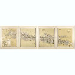
Java op een schaal van 1:950 000
Very detailed map of Java in 4 sheets, with an inset map of 'Batavia met de haven werken' (Jakarta). Taken from "Atlas van Nederlandsch Oost- en West-Indie", pr...
Date: Amsterdam, Seyffardt, 1884
Selling price: ????
Please login to see price!
Sold in 2017
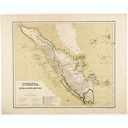
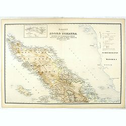
Sumatra, Bangka, Blitong, Riouw, enz. (with Singapore)
Very detailed map of Sumatra, with Singapore to the East, taken from "Atlas van Nederlandsch Oost- en West-Indie", prepared by doctor I. Dornseiffen, and publis...
Date: Amsterdam, Seyffardt, 1884
Selling price: ????
Please login to see price!
Sold in 2017
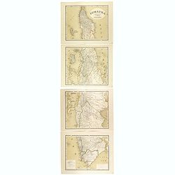
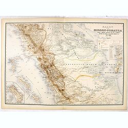
Sumatra op een schaal van 1: 1450000
Very detailed map of Sumatra on 4 sheets, taken from "Atlas van Nederlandsch Oost- en West-Indie", prepared by doctor I. Dornseiffen, and published by published...
Date: Amsterdam, Seyffardt, 1884
Selling price: ????
Please login to see price!
Sold in 2017
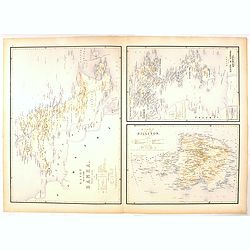
Bangka en Blitong op een schaal van 1:750000.
Very detailed two sheet map of Bangka en Blitong, taken from "Atlas van Nederlandsch Oost- en West-Indie", prepared by doctor I. Dornseiffen, and published by p...
Date: Amsterdam, Seyffardt, 1884
Selling price: ????
Please login to see price!
Sold in 2018
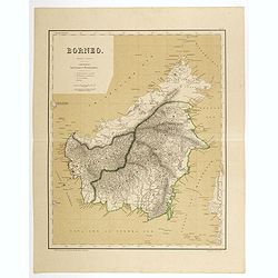
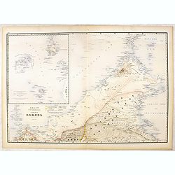
Borneo op een schaal van 1:420000.
Very detailed two sheet map of Borneo with some good detail to Brunei as well, taken from "Atlas van Nederlandsch Oost- en West-Indie", prepared by doctor I. Do...
Date: Amsterdam, Seyffardt, 1884
Selling price: ????
Please login to see price!
Sold in 2017
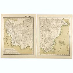
Borneo op een schaal van 1:1800000.
Very detailed two sheet map of Southern part of Borneo in two sheets, taken from "Atlas van Nederlandsch Oost- en West-Indie", prepared by doctor I. Dornseiffen...
Date: Amsterdam, Seyffardt, 1884
Selling price: ????
Please login to see price!
Sold in 2017
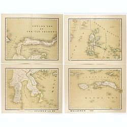
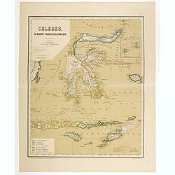
Celebes en de Molukken in vier bladen.
Very detailed four-sheet map of Celes and the Moluccas on a scale of 1:1800000, taken from "Atlas van Nederlandsch Oost- en West-Indie," prepared by a doctor I....
Date: Amsterdam, Seyffardt, 1884
Selling price: ????
Please login to see price!
Sold in 2017
Celebes, de kleine Soenda eilanden, enz. Schaal van 1:4200000.
Very detailed two sheet map of Moluccas, taken from "Atlas van Nederlandsch Oost- en West-Indie", prepared by doctor I. Dornseiffen, and published by published ...
Date: Amsterdam, Seyffardt, 1884
Selling price: ????
Please login to see price!
Sold in 2017
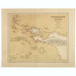
De Moluksche eilanden en Nieuw-Guinea (Nederlandsch gedeelte) . . . schaal van 1:4200000.
Very detailed two sheet map of New Guinea with good detail to the Moluccas as well, taken from "Atlas van Nederlandsch Oost- en West-Indie", prepared by doctor ...
Date: Amsterdam, Seyffardt, 1884
Selling price: ????
Please login to see price!
Sold in 2017
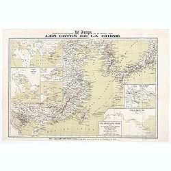
Les Côtes de la Chine supplément au journal le temps du 16 Octobre 1884
Map of the Chinese coasts, with an inset showing Europe, Africa, Arabia and the Asian continent, with part of Australia and showing the route from France to China. Publis...
Date: Paris, October 6th, 1884
Selling price: ????
Please login to see price!
Sold in 2020
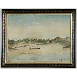
Iles Pescadores <Chine>.
Very interesting water color most probably made in Ki-lung (Jilong in northern Taiwan) by a French eye-witness during the short time France occupied the Pescadores and Fo...
Date: Kilung [Jilong], Mai 1885
Selling price: ????
Please login to see price!
Sold
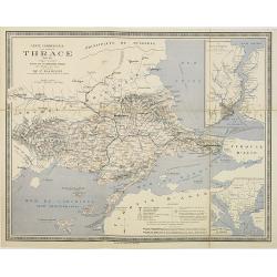
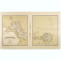
Carte commerciale de la province de Thrace. . .
Rare separately issued folding example of Bianconi's map of the European part of Turkey. F Bianconi directed a series of "Carte commerciale" of all countries; t...
Date: Paris, Librairie Chaix, 1885
Selling price: ????
Please login to see price!
Sold in 2012
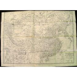
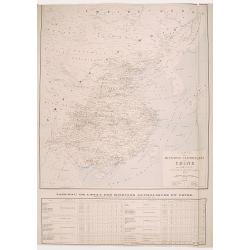
(Ortographische und geologische Karten. Erste Abtheilung: Das nördliche China.)
Very rare atlas of Northern China prepared by and during the lifetime of Ferdinand Freiherr von Richthofen. It is considered to be the first scientific atlas about China,...
Date: Berlin, D.Reimer, 1885
Selling price: ????
Please login to see price!
Sold
Overzichtskaart van den Nederlandsch oost Indischen Archipel.
Very detailed map of Indonesia, taken from "Atlas der Nederlandsche bezittingen in Oost-Indië", who was published by Departement van Koloniën". Including...
Date: The Hague, 1883-1885
Selling price: ????
Please login to see price!
Sold in 2017
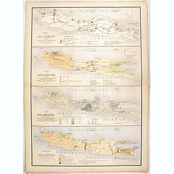
Kaart van Java en Madoera . . .
Four maps of Java and Madoera on one sheet taken from "Atlas der Nederlandsche bezittingen in Oost-Indië", who was published by Departement van Koloniën"...
Date: The Hague, 1883-1885
Selling price: ????
Please login to see price!
Sold in 2017
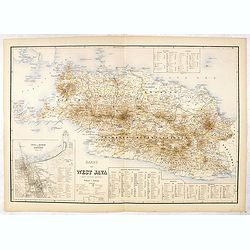
Kaart van West Java (eerste militaire afdeeling)
Very detailed map of west Java, taken from "Atlas der Nederlandsche bezittingen in Oost-Indië", who was published by Departement van Koloniën". With inse...
Date: The Hague, 1883-1885
Selling price: ????
Please login to see price!
Sold in 2016
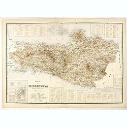
Kaart van Midden Java. ( tweede militaire afdeeling )
Very detailed map of central Java, taken from "Atlas der Nederlandsche bezittingen in Oost-Indië", who was published by Departement van Koloniën". In low...
Date: The Hague, 1883-1885
Selling price: ????
Please login to see price!
Sold in 2016
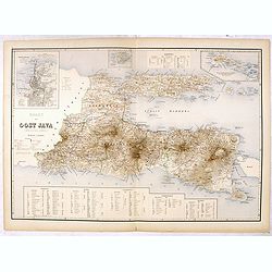
Kaart van Oost Java. (derde militaire afdeeling.)
Very detailed map of East Java taken from "Atlas der Nederlandsche bezittingen in Oost-Indië", who was published by Departement van Koloniën". With large...
Date: The Hague, 1883-1885
Selling price: ????
Please login to see price!
Sold in 2016
Kaart van Noord Sumatra: Gouvernement Atjeh en Onderhoorigheeden / Noordelijke gedeelten van de Res.n Tapanoeli en Sumatra's Oostkust / en de onafhankelijkeBatak Landen. . .
Very detailed map of Northen Sumatra, taken from "Atlas der Nederlandsche bezittingen in Oost-Indië", who was published by Departement van Koloniën".Firs...
Date: The Hague, 1883-1885
Selling price: ????
Please login to see price!
Sold in 2023
Kaart van Midden-Sumatra : Gouver.nt v. Sumatra's Westkust, Zuid ged. d. R. Sumatra's-Oostkust, Afd. Lingga v.d. Res. Riouw en Onderh. en het Rijk Djambi.
Very detailed map of Central Sumatra, taken from "Atlas der Nederlandsche bezittingen in Oost-Indië", who was published by Departement van Koloniën". Wit...
Date: The Hague, 1883-1885
Selling price: ????
Please login to see price!
Sold in 2017
Kaart van Eiland Banka / Kaart van den Riouw en Lingga Archipels / Kaart van het Eiland Billiton.
Three very detailed maps of Banka Island, Billiton and the Riouw and Lingga Archipel, taken from "Atlas der Nederlandsche bezittingen in Oost-Indië", who was p...
Date: The Hague, 1883-1885
Selling price: ????
Please login to see price!
Sold in 2016
Kaart van Het Noordelijk Gedeelte Van Het Eiland Borneo.
Very detailed map of Northern Borneo, taken from "Atlas der Nederlandsche bezittingen in Oost-Indië", who was published by Departement van Koloniën".With...
Date: The Hague, 1883-1885
Selling price: ????
Please login to see price!
Sold in 2016
Kaart van het Zuidelijk Gedeelte Van het Eiland Borneo.
Very detailed map of Southern part of Bornea, taken from "Atlas der Nederlandsche bezittingen in Oost-Indië", who was published by Departement van Koloniën&qu...
Date: The Hague, 1883-1885
Selling price: ????
Please login to see price!
Sold in 2020
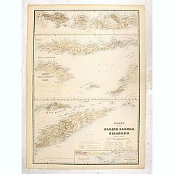
Kaart van de Kleine Soenda Eilanden.
Four very detailed maps of the Soenda Islands on one sheet taken from "Atlas der Nederlandsche bezittingen in Oost-Indië", who was published by Departement van...
Date: The Hague, 1883-1885
Selling price: ????
Please login to see price!
Sold in 2016
Ju Hachi Shiryaku - Summaries of the 18 eras, Historical maps.
A superb atlas of Chinese maps, showing the geographic extent of various Chinese dynasties.11 beautifully hand colored double page woodblock maps of China. Publisher: Moh...
Date: 1885
Selling price: ????
Please login to see price!
Sold in 2016
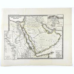
Arabia, Aethiopia, Aegyptus.
Map of the Arabian peninsula from "Histoire du Commerce du Monde". Inset maps of Egyptus Inferior and Heptanomis et Thebais.
Date: Gaotha, ca. 1885
Selling price: ????
Please login to see price!
Sold in 2020
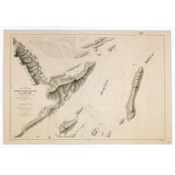
Chine. Côte Nord de Formose. Baye de Ke-Lung..
Large illustrating the bay of Keelung in Taiwan.Showing settlements, banks, isles and soundings made in metres. Relief shown by hachures.Prepared in 1884 by M.M. Renaud ...
Date: Paris, 1886
Selling price: ????
Please login to see price!
Sold in 2020
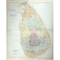
Cyprus. / London Atlas map of Cyprus.
With decorative cover title: LONDON ATLAS MAP OF CYPRUS. LONDON EDWARD STANFORD Ltd. Cartographer to the King, / 12, 13 & 14, LONG ACRE, W.C. and 29 & 30 Charing ...
Date: London, 1887
Selling price: ????
Please login to see price!
Sold in 2009
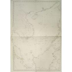
Mer de Chine. Golfe du Tonkin. Entrées de Kuaï-Chin-Mun et Tsieng-Mun. . .
Large chart centred on the Gulf of Tonkin in the South China Sea. Showing banks, isles and soundings made in metres. Relief is shown by hachures.Engraved by A. Gérin aft...
Date: Paris, 1887
Selling price: ????
Please login to see price!
Sold in 2008
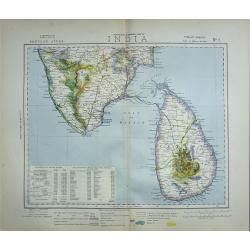
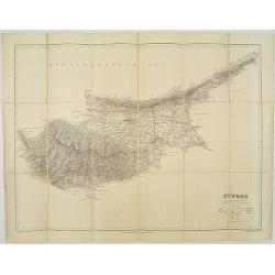
CEYLON
A fine detailed map of Ceylon with the provinces colored in separate tints. The districts are separated by narrow red lines and their names underlined in red A railway ru...
Date: London, 1887
Selling price: ????
Please login to see price!
Sold in 2014
Sheet 2 (Western Route to China).
Impressively sized sea-chart of a part of the Java Sea. Shows Indramayu to Semarang on Java, the Karimunjawa Islands, a small part of Borneo, and a part of Belitung (Bill...
Date: London, 1887
Selling price: ????
Please login to see price!
Sold in 2014
Map of Tokyo.
A very attractive folded engraved map of Tokyo in the Japanese and English languages in woodblock color. It shows views of tourist attractions. It includes an address cha...
Date: Tokyo, 1887
Selling price: ????
Please login to see price!
Sold in 2018
East India archipelago Western route to China, chart No.3.
Huge sailing of Gulf of Siam and South China Sea. Centering on Gulf of Siam, with a large inset of Gulf of Bangkok. Seven other insets, among, Saigon, River Bangkok, Pul...
Date: London, 1888
Selling price: ????
Please login to see price!
Sold in 2013
A complete set of 21 humorous Punch prints with Japan interest 1888.
This set of 21, numbered 1 – 21 cartoon prints are from Punch published between May1888 – November 1888. Mostly engraved by Joseph Swain. Joseph Swain was one of the ...
Date: London, 1888
Selling price: ????
Please login to see price!
Sold in 2017
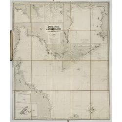
![East India archipelago [Western route to China, chart No. 6].](/uploads/cache/29948-250x250.jpg)
East India archipelago [Western route to China, chart No. 6].
Huge sailing chart showing the China Sea covering southeastern China in the vicinity of Hong Kong and Guangdong Province, southern Taiwan, and the northern Philippines (L...
Date: London, 1888
Selling price: ????
Please login to see price!
Sold in 2018
Carte des Missions Catholiques en Chine.
Uncommon and detailed map of China, Korea and Taiwan; includes also a description of the Catholics missions in China giving population and the number of missionaries, etc...
Date: Lyon, 1890
Selling price: ????
Please login to see price!
Sold in 2008
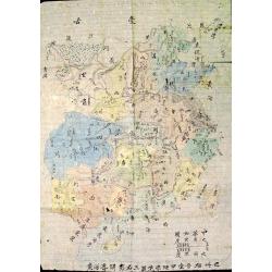
The Complete Map of China (Zhonghua Quantu)
Rare survival of a student's geography work in China, traced and colored by a late Qing Dynasty schoolboy. Not only commercial map makers made maps. Students and young pe...
Date: c. 1890
Selling price: ????
Please login to see price!
Sold in 2012
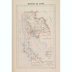
Mission de Siam.
Important map of Thailand, prepared by Adrien Launay, who was a French Missionary and later chronicer of the history of the French Missions in Indo-China at end of the 19...
Date: Lille, 1890
Selling price: ????
Please login to see price!
Sold

Japon
An interesting chromolithograph semi-cartoon map of Japan with several views from the middle 19th century.It features a boy carrying water, men playing with puppets, and ...
Date: Haarlem, ca. 1890
Selling price: ????
Please login to see price!
Sold in 2017
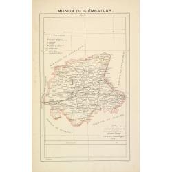
Mission du Coïmbatour.
Important missionary centered on Coimbatour. It is the Third largest city and urban agglomeration in the Indian state of Tamil Nadu, prepared by Adrien Launay, who was a ...
Date: Lille, 1890
Selling price: ????
Please login to see price!
Sold in 2017
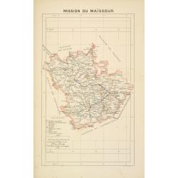
Mission du Maïssour.
Important missionary map centered on Mysor, prepared by Adrien Launay, who was a French Missionary and later chronicler of the history of the French Missions in Indo-Chin...
Date: Lille, 1890
Selling price: ????
Please login to see price!
Sold in 2017
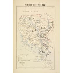
Mission du Cambodge.
Important missionary map showing Cambodia, prepared by Adrien Launay, who was a French Missionary and later chronicler of the history of the French Missions in Indo-China...
Date: Lille, 1890
Selling price: ????
Please login to see price!
Sold in 2015
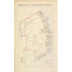
Mission de Cochinchine orientale.
Important missionary map showing central part of Vietnam, prepared by Adrien Launay, who was a French Missionary and later chronicler of the history of the French Mission...
Date: Lille, 1890
Selling price: ????
Please login to see price!
Sold in 2016
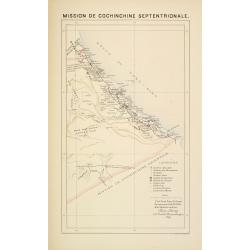
Mission de Cochinchine septentrionale.
Important missionary map showing part of Vietnam, prepared by Adrien Launay, who was a French Missionary and later chronicler of the history of the French Missions in Ind...
Date: Lille, 1890
Selling price: ????
Please login to see price!
Sold in 2016
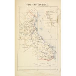
Tong-King Méridional.
Important missionary map showing part of Vietnam, prepared by Adrien Launay, who was a French Missionary and later chronicler of the history of the French Missions in Ind...
Date: Lille, 1890
Selling price: ????
Please login to see price!
Sold in 2016
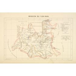
Mission du Yun-Nan.
Important missionary map showing part of China, prepared by Adrien Launay, who was a French Missionary and later chronicler of the history of the French Missions in Indo-...
Date: Lille, 1890
Selling price: ????
Please login to see price!
Sold
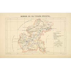
Mission du Su-Tchuen Oriental.
Important missionary map showing part of China, prepared by Adrien Launay, who was a French Missionary and later chronicler of the history of the French Missions in Indo-...
Date: Lille, 1890
Selling price: ????
Please login to see price!
Sold
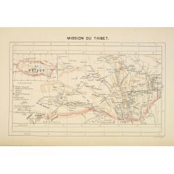
Mission du Thibet.
Important missionary map showing Tibet, prepared by Adrien Launay, who was a French Missionary and later chronicler of the history of the French Missions in Indo-China at...
Date: Lille, 1890
Selling price: ????
Please login to see price!
Sold
Asiatic Archipelago on Mercator's projection.
Charming, folding map of Indonesia, with Philippines, Papua New Guinea, and inset maps of Singapore (80x12mm.) and Labuan (65x72mm.), a federal territory of Malaysia off ...
Date: London, ca. 1890
Selling price: ????
Please login to see price!
Sold in 2015
Ju Hachi Shiryaku - Summaries of the 18 eras.
A wonderful medium-sized atlas of Chinese maps, showing the geographic extent of various Chinese dynasties.10 woodblock maps of China - 2 maps per page. Meiji 22. Maps by...
Date: Meiji 22 or ca. 1890
Selling price: ????
Please login to see price!
Sold in 2016

Bilder aus den Tatarischen Dörfern in Russland.. II. Bogen.
Originally hand colored wood block engravings, published in "Münchener Bilderbogen" and published ca. 1890.
Date: München, 1890
Selling price: ????
Please login to see price!
Sold in 2016
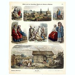
Bilder aus den Tartarischen Dörfern bei Kasan in Rusland. I. Bogen.
Originally hand colored wood block engravings, published in "Münchener Bilderbogen" and published ca. 1890.
Date: München, 1890
Selling price: ????
Please login to see price!
Sold in 2016
Singapore.
A simplified plan of Singapore, including streets and rivers. Names the Racecourse, the Palace of the Governor, Fort Canning, and the Battery. Indicates the depth of the ...
Date: London, ca. 1890
Selling price: ????
Please login to see price!
Sold in 2016
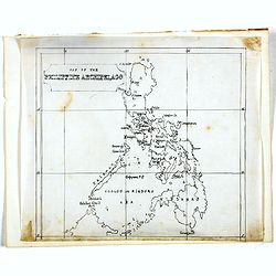
Manuscript map of the Philippine Archipelago.
An unusual small, and basic manuscript map of the Philippine Archipelago. Many small islands named.
Date: London, ca. 1890
Selling price: ????
Please login to see price!
Sold in 2016
![[Untitled] Map of Northern India, Tibet, Nepal, Bhutan and surrounding countries.](/uploads/cache/42031-250x250.jpg)
[Untitled] Map of Northern India, Tibet, Nepal, Bhutan and surrounding countries.
The top sheet (No.47) of a two sheet map centered on Nepal, Bhutan and Tibet. Also covered by the map are: Northern India, Afghanistan, Pakistan, Turkistan, far Eastern C...
Date: London, ca 1890
Selling price: ????
Please login to see price!
Sold in 2018
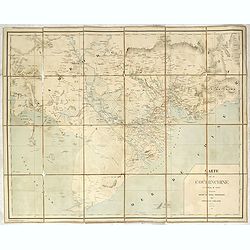
Carte de la Cochinchine.
Uncommon map of Cochin chine, prepared by captain Friquegnon. Printed in Hanoï by F.H.Schneider.
Date: Hanoï, 1890
Selling price: ????
Please login to see price!
Sold in 2019
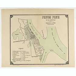
Plan Phnom Penh et ses environs.
Early French map of Phnom Penh and its surroundings. Printed by. F. H. Schneider in Hanoi. Recruited as an agent at the colonial printing press in Saigon in 1882, he was ...
Date: Hanoï, ca. 1890
Selling price: ????
Please login to see price!
Sold in 2020