Browse Listings in Asia

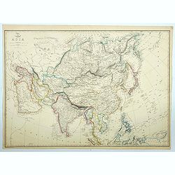
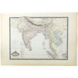
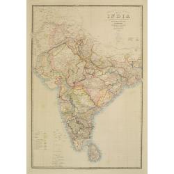
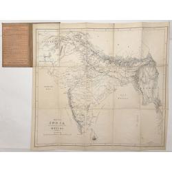
The British Possessions In The East Indies, With The Dependent States And Countries Adjacent.
Fantastic map of India, Pakistan, Afganistan, Tibet, Bhutan, and the Himalayas. Extending east to show Siam. With a small inset of the southern India and Ceylon. Large...
Date: Edinburgh, c1860
Selling price: ????
Please login to see price!
Sold in 2013
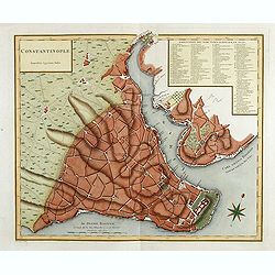
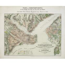
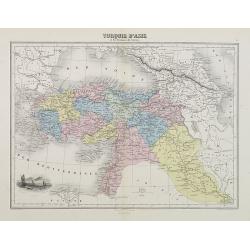
Constantinople superficie 3,975,000 Toises.
Town-planof Istanbul and its environs in Asia. With a numbered key (1-86) to principal places of interest. Engraved by Pierre François Tardieu (1711 - 1771).
Date: Paris, 1860
Selling price: ????
Please login to see price!
Sold in 2014
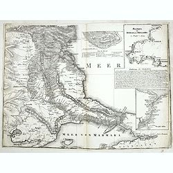
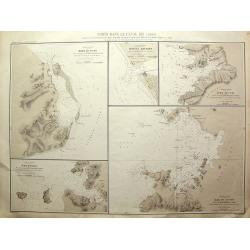
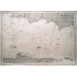
Meerbusen von Burgas oder Mesambri im Maasstab von 1:200.000. . . .
The lower part of a two-sheet map entitled "Karte der Hauptstraßen von der niederen Donau bis Constantinopel. . . ." The map has 4 insets with "Meerbusens...
Date: Berlin, ca.1860
Selling price: ????
Please login to see price!
Sold in 2015
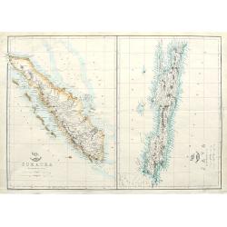
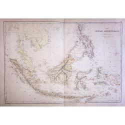
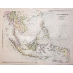
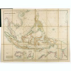
Sumatra; Java;
Two maps on one sheet. Both maps are highly detailed, filled with place names. The Sumatra map shows also Malaysia and Singapore. "The Weekly Dispatch" newspa...
Date: London, ca. 1860
Selling price: ????
Please login to see price!
Sold in 2018
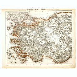
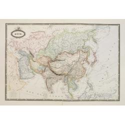
Specialkarte der Asiatischen Turkey : 1. Blatt Anadoli (Klein - Asien)
Steel engraved map of western part of Turkey, engraved by Ifslieb and J. Grassl for Druck u. Verlag des Bibliographischen Instituts in Hildburghausen, 1860.Included in &q...
Date: Hildburghausen, 1860
Selling price: ????
Please login to see price!
Sold in 2016
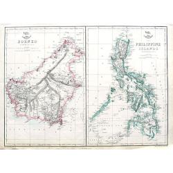
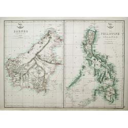
Borneo; The Philippine Islands;
Two maps on one sheet. Both maps are highly detailed, filled with place names.
Date: London, ca. 1860
Selling price: ????
Please login to see price!
Sold in 2018
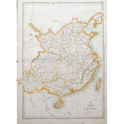
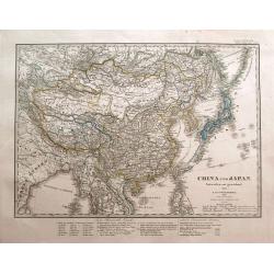
China.
A map of China and Taiwan, highly detailed, filled with place names.The Weekly Dispatch newspaper was published in London between the years 1856 and 1862, and included in...
Date: London, ca. 1860
Selling price: ????
Please login to see price!
Sold in 2018
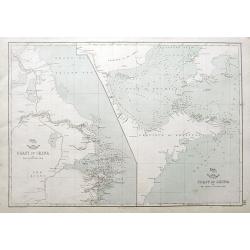
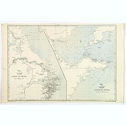
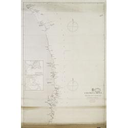
Coast of China. . .
Two charts on one sheet: The coast of China from Nyew tew Island to Hae-Chow; and the Coast of China from Hae-Chow to Leaotong Gulf. Both maps are highly detailed, filled...
Date: London, ca. 1860
Selling price: ????
Please login to see price!
Sold in 2018
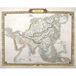
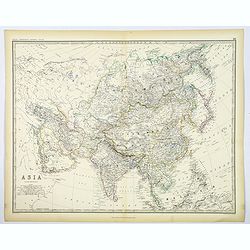
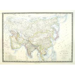
Asia.
Detailed steel engraved map by J. Rapkin, who also worked on the famous Tallis map. This map being almost identical to the Tallis version, only without the vignettes.
Date: London, ca. 1860
Selling price: ????
Please login to see price!
Sold in 2018
Borneo; The Philippine Islands.
Two maps on one sheet. Both maps are highly detailed, filled with place names. The Philippines are shown from the Bashee Islands in the north to the Sooloo Archipelago in...
Date: London, ca 1860
Selling price: ????
Please login to see price!
Sold in 2018
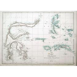
Celebes and the Molucca Islands.
A highly detailed map of the islands, also known as the Spice Islands, Celebes and Maluku Islands or the Moluccas, with many even small islands depicted. It depicts bays,...
Date: London, ca 1860
Selling price: ????
Please login to see price!
Sold in 2018
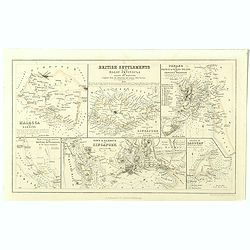
British settlements in the Malay peninsula and coast of Borneo . . .
Set of six little maps on one sheet, including a map of the Coast of Borneo, Singapore, Malacca, etc. Engraved by J. Bartholomew.
Date: London, A.Fullarton, c. 1860
Selling price: ????
Please login to see price!
Sold in 2019
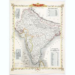
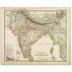
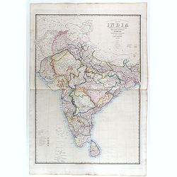
British India.
A late edition map of British India, published by the London Printing and Publishing Company. Replacing the decorative vignettes of earlier editions are tables of signifi...
Date: London, 1860
Selling price: ????
Please login to see price!
Sold in 2020
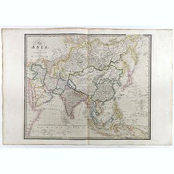
Asia.
The large map of the continent of Asia appeared in the part-work "Dispatch Atlas" issued in supplements and ultimately as a complete volume. A detailed map with...
Date: London, 1860
Selling price: ????
Please login to see price!
Sold in 2021
Asie Occidentale. Turquie..Arabie, Perse, Turkestan..
Very detailed map from Atlas Sphéroïdal & Universel de géographie. Prepared by F.A.Garnier and edited by Jules Renouard, rue de Tournon, Paris. Uncommon map with d...
Date: Paris, 1861
Selling price: ????
Please login to see price!
Sold in 2011
Asie.
Very detailed map from Atlas Sphéroïdal & Universel de géographie. Prepared by F.A.Garnier and edited by Jules Renouard, rue de Tournon, Paris. Uncommon map with d...
Date: Paris 1861
Selling price: ????
Please login to see price!
Sold in 2008
Turquie D'Asie Syrie, Liban. Region du Caucase.
Very detailed map from Atlas Sphérodïdal & Universel de géographie , Prepared by F.A.Garnier and edited by Jules Renouard, rue de Tournon, Paris. Uncommon map with...
Date: Paris, 1861
Selling price: ????
Please login to see price!
Sold in 2008
Asie spheroidale.
Very detailed map from Atlas Spherodidal & Universel de geographie , Prepared by F.A.Garnier and edited by Jules Renouard, rue de Tournon, Paris. Uncommon map in an u...
Date: Paris, 1861
Selling price: ????
Please login to see price!
Sold in 2018
Asie Meridionale. Inde Anglaise et Indo-Chine.
Very detailed map from Atlas Spherodidal & Universel de geographie , Prepared by F.A.Garnier and edited by Jules Renouard, rue de Tournon, Paris. Uncommon map with de...
Date: Paris, 1861
Selling price: ????
Please login to see price!
Sold in 2020
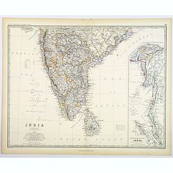
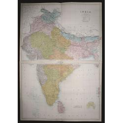
India (Southern Sheet).
A large and detailed steel engraved map sheet (1 of 2 only) of Southern India. Map extent is from Nagpur in the north to Ceylon (Sri Lanka) in the south. Regions are in d...
Date: London, 1861
Selling price: ????
Please login to see price!
Sold in 2021
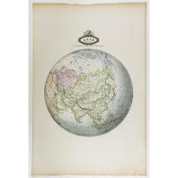
Asia.
A large, highly detailed map of the continent of Asia, from Johnston's General Atlas published around 1860 in Edinburgh. Various countries are highlighted in differing ou...
Date: Edinburgh, ca 1861
Selling price: ????
Please login to see price!
Sold in 2020
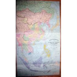
ASIE ORIENTALE comprenant L'EMPIRE CHINOIS ET LE JAPON LES ETATS DE L'INDO-CHINE ET LE GRAND ARCHIPEL D'ASIE
Early edition of the rare wall-map of the Far East by Andriveau-Goujon. Shows the Far East, from Russia, with Tibet, China, Korea, Thailand, Singapore, Indonesia, unti...
Date: Paris, 1862
Selling price: ????
Please login to see price!
Sold in 2011
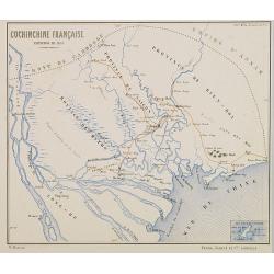
Carte provisoire de la basse Cochinchine. Dressée par Ordre de Mr. le Vice Amiral Charner Commandant en Chef l'Escadre des Mers de Chine . . .
Map of Cochinchina prepared by L.Manen for the French Dépôt de la Marine. Engraved by Jacobs.Saigon is in the center. The map has red manuscript lines drawn in. In lowe...
Date: Paris, 1862
Selling price: ????
Please login to see price!
Sold in 2015
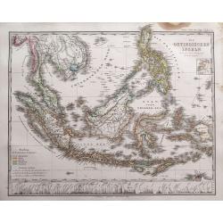
Die Ostindischen Inseln entw. u. gez. von F. v. Stülpnagel und Herm. Berghaus.
Superb map of Indonesia, filled with place names. Shows the area from Thailand to Papua New Guinea, including the Philippines, Singapore, Malaysia, Borneo, and the Indone...
Date: Gotha, 1862
Selling price: ????
Please login to see price!
Sold in 2014

Prise de Canton 28 et 29 Décembre 1857.
A rare plan of Canton prepared by Captain Labbe. Plate II from "Atlas de l'expédition de Chine en 1860: rédigé au dépôt de la guerre d'après les documents offi...
Date: Paris, 1862
Selling price: ????
Please login to see price!
Sold in 2018
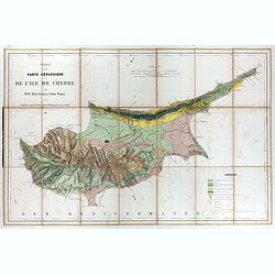
Essai d'une carte géologique de l'Ile de Chypre.
Geological map of Cyprus prepared by Albert Gaudry (1827-1908), professor at Muséum d'histoire naturelle and member of the London Royal society of Sciences.A color key i...
Date: Paris, 1862
Selling price: ????
Please login to see price!
Sold in 2017
Coast of China. Nyew tew island to Hae Chow / Hae Chow to Leaotong Gulf.
A pair of coastal maps of China, published in the Weekly Dispatch Atlas circe 1862. The map information is mainly confined to the coast, but there is some detail inland a...
Date: London, ca 1862
Selling price: ????
Please login to see price!
Sold in 2020
Küstenansichten eines Theiles der Insel NIPPON..
Prepared by Officer S.M.S. Arcona during the German expedition of 1860-1861 to South East Asia. Lithographed by Lippold and printed by C.Ulrich of Berlin. Sheet 1 from a ...
Date: Berlin, 1863
Selling price: ????
Please login to see price!
Sold in 2013
China und Japan. Entworfen und gezeichnet von F. von Stülpnagel. 1850 bereicht v. Herm. Berghaus.
Interesting and highly detailed map of the Far East, centered on China. Includes Japan, Taiwan, northern Philippines, Tibet, Mongolia, Nepal, parts of India, Myanmar, Tha...
Date: Gotha, 1863
Selling price: ????
Please login to see price!
Sold in 2014
Vorder-Indien oder das Anglo-Indische Reich.
This is a nice example of Stieler's 1863 map of the Indian subcontinent. It covers from the Himalayas in the north as far south as Ceylon (Sri Lanka), and from Sindh in t...
Date: Gotha, 1863
Selling price: ????
Please login to see price!
Sold in 2020
![Coast of China [2 maps].](/uploads/cache/45479-250x250.jpg)
Coast of China [2 maps].
A pair of Chinese coastal maps: The first from Nyew Tew Island to Hae-Chow. The second from Hae-Chow to Leaotong Gulf. Both show depth soundings, numerous bays and inlets...
Date: London, ca 1863
Selling price: ????
Please login to see price!
Sold in 2023
Map of India. . .
Very detailed road, railway and telegraphic map of India showing the post roads. With color key to British possessions, independent-, protected- and subsidiary states. Se...
Date: London, 1855/1864
Selling price: ????
Please login to see price!
Sold
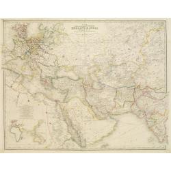
Map of the countries inbetween England & India..
Very detailed map of the countries between England and India, designed to show the over-land and sea routes to the East. In lower left-hand corner inset map of the easter...
Date: London, 1855/1864
Selling price: ????
Please login to see price!
Sold
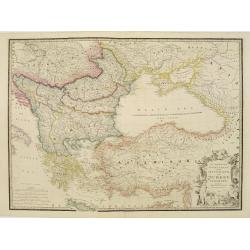
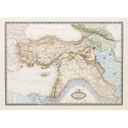
European Dominions of the Ottomans or Turkey in Europe..
Very detailed map of Turkey, Greece and the Black Sea. Northern part of Cyprus is included. Railways indicated.James Wyld (the younger) was geographer to the Queen and H....
Date: London, 1855/1864
Selling price: ????
Please login to see price!
Sold in 2009
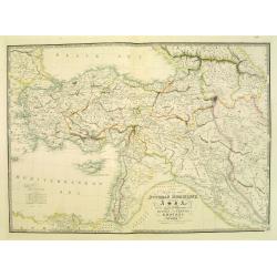
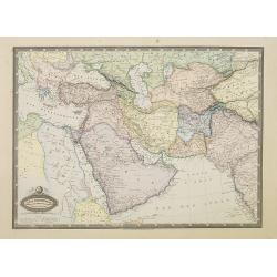
Map of the Ottoman Dominions in Asia. . .
Very detailed map of Turkey, Palestine, Azerbijan, Kurdistan, Georgia and Cyprus.James Wyld (the younger) was geographer to the Queen and H.R.H. Prince Albert. Joined his...
Date: London, 1855/1864
Selling price: ????
Please login to see price!
Sold in 2009
Ports dans le Canal Kii (Japon).
Rare Admiralty Chart with 5 large scale maps on one sheet: Shows the harbour of Jura; the Hachken river, Yura No Uchi, Bay of Tanabe, Bay of Osaki.All 5 charts with much ...
Date: Paris, 1864
Selling price: ????
Please login to see price!
Sold in 2011
Nangasaki.
A fine bird's-eye view showing Deshima (the head quarter of the V.O.C.) and Nagasaki bay. From Die Preussische Expedition nach Ost Asien . With many European ships in the...
Date: Berlin, 1864
Selling price: ????
Please login to see price!
Sold in 2015

Johnson's China.
Very detailed map of China. Includes Formosa (Taiwan) and Korea. With an inset map of Canton area including Hong Kong; and a second inset map of Amoy (Xiamen) Island. ...
Date: New York, 1864
Selling price: ????
Please login to see price!
Sold in 2012
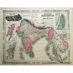
Johnson's Hindostan or British India.
Attractive steel engraved map, extending from the Indus River eastwards with India, Burma, Siam (Thailand), Laos, Cambodia, Malaysia (Malacca), Singapore, and Vietnam (To...
Date: New York, 1864
Selling price: ????
Please login to see price!
Sold in 2012
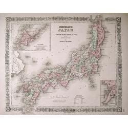
Johnson's Japan; Nippon, Kiusiu, Sikok, Yesso and the Japanese Kuriles.
An attractive map with insets of Yesso and the Japanese Kuriles, and the Bay of Nagasaki. The detailed map was compiled from the maps of Siebold and the surveys of the U....
Date: New York, c1864
Selling price: ????
Please login to see price!
Sold in 2013
Carte de la mer de Java (partie orientale).
Large-scale sea-chart of the Java Sea. Shows parts of Java with Semarang, Surabaya; Madura island, Pulau Kangean, Bawean, Pulau Karimun Jawa, and southern part of Bornea ...
Date: Paris, 1864
Selling price: ????
Please login to see price!
Sold in 2014
THE INDIAN ARCHIPELAGO (Indonesia & Borneo)
Original steel engraved map drawn & engraved by Edward Weller, published by Blackie & Son, in Edinburgh 1864.
Date: Edinburgh, 1864
Selling price: ????
Please login to see price!
Sold in 2015
Plan de Saïgon et de ses environs, Levé par M. Foester, Capitaine d'état major.
Map of Saigon and the surrounding area, Surveyed by Mr. Foester, Captain, published by Imprimerie du Gouvernement. Saïgon 1864.Provenance : Pierre-Paul de La Grandière ...
Date: Saigon, 1864
Selling price: ????
Please login to see price!
Sold in 2020
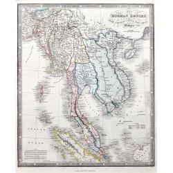
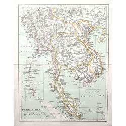
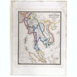
Map of the Burman Empire including also Siam, Cochin-China, Ton-King, and Malaya.
A fine map of the area, including today's Thailand, Vietnam, Sincapore (Singapore), and a part of Borneo. Notes of size and population of Birman Empire, Anam, Siam, Malay...
Date: London, 1864
Selling price: ????
Please login to see price!
Sold in 2021
Temple at Tumai, Lew Chew.
Lithography of Americans visiting Korea. After a drawing by Heine, who was one of the members of Captain Perry's mission to Japan and Korea.One of the Americans is a phot...
Date: New York, 1865
Selling price: ????
Please login to see price!
Sold in 2012
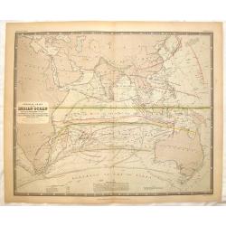
Physical Chart of the Indian Ocean Showing the Temperature of the Water.
This interesting map shows the currents of the air and oacean , direction of the wind , distracts of hurricanes, regions of the monsoons & tyfoons and the temperature...
Date: Edinburgh, 1865
Selling price: ????
Please login to see price!
Sold in 2015
Burma, Siam, &c.
Interesting map, extending from Bangladesh until China with Hainan island, and as far south as Singapore. Filled with place names, rivers, mountains, islands, etc.
Date: London, c1865
Selling price: ????
Please login to see price!
Sold in 2018
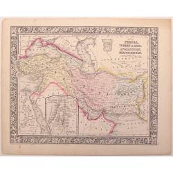
Map of Persia, turkey in Asia,,Afghanistan, Beloochistan.
An example of the beautiful maps of Augustus Mitchell. This map covers the modern day countries of Turkey, Iran, Iraq, Syria, Jordan and Afghanistan. There is an inset of...
Date: New York, 1866
Selling price: ????
Please login to see price!
Sold in 2016
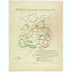
Map of China showing the locality of the different rebellions in that Empire, the line of retreat taken by the Ti-pings from their settled territory, and their present position Spring of the year 1866.
Map of China showing the locality of the different rebellions in that Empire, the line of retreat taken by the Ti-pings from their settled territory, and their present po...
Date: London, circa 1867
Selling price: ????
Please login to see price!
Sold in 2017
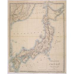
The islands of Japan by James Wyld..
Very detailed map of Japan, including part of the coast of Korea with Busan harbor. Including tracks of explorers, Krusenstern (1804), Providence (1796), Argonaut (1797),...
Date: London, 1868
Selling price: ????
Please login to see price!
Sold in 2013
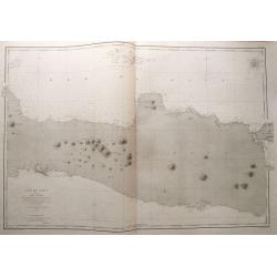
Ile de Java 1ère Feuille Partie Occidentale. . .
Large size sea-chart of the Sunda Strait. Shows parts of Sumatra and Java (extending east until Cirebon). With numerous small islands shown, depth soundings and anchoring...
Date: Paris, 1869
Selling price: ????
Please login to see price!
Sold in 2014
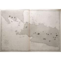
Ile de Java 2ème Feuille Partie Centrale. . .
Large size sea-chart of central Java. Extends from Indramayu until Madura. Includes Karimunjawa and Bawean in great detail. With depth soundings and anchoring places. Onl...
Date: Paris, 1869
Selling price: ????
Please login to see price!
Sold in 2014
![[untitled map of Japan]](/uploads/cache/91045-250x250.jpg)
[untitled map of Japan]
Superb 19th century woodblock printed map of Japan. Very large size and scale, with excellent detail. Strikingly decorative and skillfully executed. With nice hand-colori...
Date: Japan, c1870
Selling price: ????
Please login to see price!
Sold in 2010
Plan de Constantinople avec ses faubourgs, le port et une partie du Bosphore..
Decorative and very detailed plan of Istanbul and its environs. With title and dedication in German and French. Lower part key to symbols.Rare in this uncut state, usuall...
Date: Berlin 1870
Selling price: ????
Please login to see price!
Sold in 2015
Indian Archipelago and Further India. Including Burmah, Siam, Anam &c.
The map covers the area from India - China - Formoza (Taiwan) in the North to New Guinea and the tip of Australia in the South.
Date: Edinburgh, 1870
Selling price: ????
Please login to see price!
Sold in 2014
India ( on two sheets)
An extremely highly detailed map of India printed over two sheets North & South, color-coded for the different provinces. The South sheet has Ceylon (present day Sri ...
Date: Edinburgh 1870
Selling price: ????
Please login to see price!
Sold in 2015
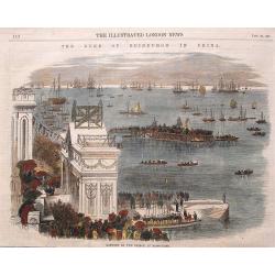
Landing of the Prince at Hong-Kong.
Nice view of the harbour with numerous ships celebrating the arrival of the Prince Alfred - the Duke of Edinburgh in Hongkong. From the Illustrated London News, January 2...
Date: London, 1870
Selling price: ????
Please login to see price!
Sold in 2016
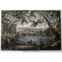
The Enchanted Lake in the Philippine Islands.
Original wood engraving drawn by Lancelot and engraved by Maurand. Beautiful scene of the lake with a deer and a crocodile. Attractive hand color.
Date: London, c1870
Selling price: ????
Please login to see price!
Sold in 2016

Great Fire at Hong-Kong.
A view of several buildings burning with a number of people in the foreground. From the Illustrated London News, ca. 1865-1870.
Date: London, ca. 1870
Selling price: ????
Please login to see price!
Sold in 2017
Cochin China. Phan-Rang Bay to Touron Bay.
Coastal chart of Cochin China and the Phan-Rang and Touron Bays. From a survey made in 1798 by Jean Dayot, and subsequently by French surveyors from 1865-66.The colonizat...
Date: 1865-1866, updated to 1871
Selling price: ????
Please login to see price!
Sold in 2018
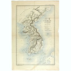
TYO SYEN Corée par les Missionnaires de Corée de la société des missions etrangéres.
A very nice map and rare map of Korea. Prepared by R.P.Carceri who was an missioner active for de la Sociéte des Missions Etrangères.Published as a supplement to Journa...
Date: Lyon, 1872
Selling price: ????
Please login to see price!
Sold in 2023

Carte du Kiang Nan ..
Detailed and very rare map of the area of Shanghai, showing the location of the missionaries' residences during the years 1871-72. P. Carceri was an missionary active for...
Date: Lyon 1872
Selling price: ????
Please login to see price!
Sold
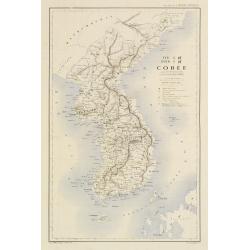
TYO SYEN Corée par les Missionnaires de Corée de la société des missions etrangéres.
A very nice map and rare map of Korea. Prepared by R.P.Carceri who was an missioner active for de la Sociéte des Missions Etrangères.Published as a supplement to Journa...
Date: Lyon, 1872
Selling price: ????
Please login to see price!
Sold
Map of India to Illustrate the History of the Mutiny .
An unusual subject for this folding map of India by James Wyld the junior, the map covers the area from Afghanistan and Cashmere in the North to Ceylon(Sri Lanka) in the ...
Date: London, 1872
Selling price: ????
Please login to see price!
Sold in 2016
Road, Railway & Telegraphic map of India shewing the post roads and dawk stations. . .
A large, decorative post road map also showing Indian railways. A color key is showing British possessions, subsidiary states, and protected and independent areas. Scale ...
Date: London, ca. 1872/1873
Selling price: ????
Please login to see price!
Sold in 2019
Map of Asia. . .
A large map of Asia. The map is of interest for being one of the few 19th century maps with the use of Gulf of Corea, for the sea between Korea and Japan. From "A Ne...
Date: London, ca. 1872/1873
Selling price: ????
Please login to see price!
Sold
Map of the Burman Empire Including also Siam, Cochin-China, Ton-king and Malaya.
Superb map showing South East Asia, from Calcutta to Hong Kong. Includes many regions and place names such as the Burman Empire, Siam (Thailand), Cochin China and Tonking...
Date: London, ca. 1872/1873
Selling price: ????
Please login to see price!
Sold in 2017
South Japan Marine Chart.
Marine chart by Amirale Cécile in 1846, but corrections in 1870 and 1873 by the Dépôt général de la marine. Meji period. A wonderful chart of the very southern part ...
Date: Paris, 1873
Selling price: ????
Please login to see price!
Sold in 2021
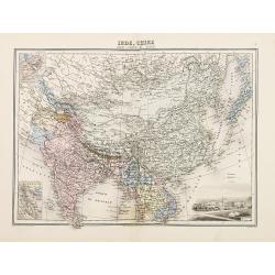
Inde, Chine
Decorative map of India and China from Géographie Universelle, Atlas Migeon. published by J. Migeon. Engraving by Schroeder of a view of Calcutta in the lower right corn...
Date: Paris 1874
Selling price: ????
Please login to see price!
Sold
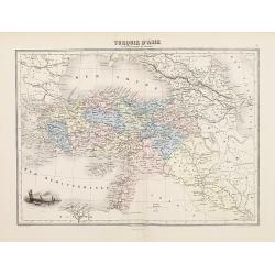
Turquie d'Asie
Decorative map of Turkey from Géographie Universelle, Atlas Migeon. published by J. Migeon. Very nice engraving of a view of Izmir (Smirna, Smyrna). Engraving by Sengtel...
Date: Paris, 1874
Selling price: ????
Please login to see price!
Sold in 2009
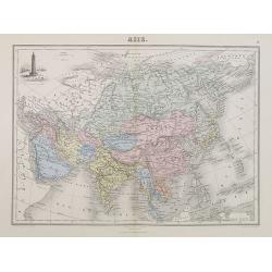
Asie.
A decorative map of Asia from Géographie Universelle, Atlas Migeon, published by J. Migeon. With an engraving of the Porcelain Tower in Nanjing in the upper left corner....
Date: Paris, 1874
Selling price: ????
Please login to see price!
Sold in 2018
Turquie d'Asie et les Provinces du Caucase.
A decorative map of Turkey, Syria, Iraq, and Iran from Géographie Universelle, Atlas Migeon, published by J. Migeon. With an engraving of the ancient city of Smyrna in I...
Date: Paris, 1874
Selling price: ????
Please login to see price!
Sold in 2009
Cochinchine Française Expedition de 1858.
Map of Cochin china centered on Saigon and showing in red the French expedition of 1858. Published in "Atlas de Géographie Militaire adopté par M. le min. de la gu...
Date: Paris, Furne, Jouvet et Cie, 1875
Selling price: ????
Please login to see price!
Sold in 2008
Nouvelle carte de l'Asie et des îles qui en dépendent dressée par A.Brué Géographe revue et argumentée par A. Vuillemin . . .1876
Very large, highly detailed and uncommon issue of the map of Asia prepared by A. Vuillemin after Adrien Hubert Brué (1786-1832).The map has shipping lines added and in l...
Date: Paris, 1876
Selling price: ????
Please login to see price!
Sold in 2015
Asiatic Archipelago.
Map of the South East Asia with very good detail on Philippines. In lower left corner inset of Singapore Island. An extensive note on Singapore 'Singapore was granted to ...
Date: London, 1876
Selling price: ????
Please login to see price!
Sold in 2019
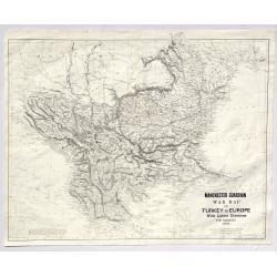
Manchester Guardian War Map of Turkey in Europe with Latest Divisions and Railways 1876.
A fine detailed War Map of Turkey in Europe with Latest Divisions and Railways 1876. It was an insert in the Manchester Gaurdian newspaper. It was published by W. & K...
Date: Edinburgh, 1876
Selling price: ????
Please login to see price!
Sold in 2019
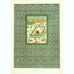
Faïences murales.
Beautiful lithograph representing the Kaabah and its surrounding. From the author's "L'Art Arabe d'après les monuments du Kaire?". Emile Prisse d'Avennes, Orie...
Date: Paris, 1877
Selling price: ????
Please login to see price!
Sold
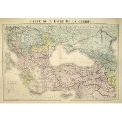
Carte du théatre de la guerre.
Very detailed map centered on the Black Sea and Cremea, including Turkey, Greece, Cyprus, etc. The map is hand colored according to the color key in the lower left. Uncom...
Date: Paris, ca. 1877
Selling price: ????
Please login to see price!
Sold in 2010
Chine. Golfes de Pe-Tchi-Li et de Liau-Tung partie nord de la mer jaune. . .
Sea chart the northern part of the yellow sea encompassing the Pe-Tchi-Li and Liau-Tung Gulfs. In lower right the west coast of North Korea.An updated coastline by Capt. ...
Date: Paris, 1863 updated for 1877
Selling price: ????
Please login to see price!
Sold
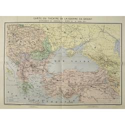
Carte du Théatre de la Guerre en Orient supplement au journal Le Temps du 30 avril 1877.
Map of the 1877 Russo-Turkish war. Drawn and engraved by R. Hausermann, 27 Rue St Andre des Arts Paris.The Russo-Turkish War of 1877-1878 had its origins in a rise in nat...
Date: Paris, after 1877
Selling price: ????
Please login to see price!
Sold in 2009