Browse Listings in Asia
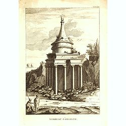
Tombeau d'Absalom.
Print showing Tomb of Absalom, also called Absalom's Pillar, which is an ancient monumental rock-cut tomb with a conical roof located in the Kidron Valley in Jerusalem. F...
Date: Paris, M. L. Migne, 1844-1846
Selling price: ????
Please login to see price!
Sold in 2016
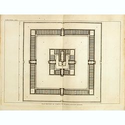
Plan nouveau du temple de Salomon, suivant l'auteur.
Print showing the new plan of Solomon's Temple. From "Atlas géographique et iconographique du Cours complet d'Écriture sainte... gravé... sous la direction de Th�...
Date: Paris, M. L. Migne, 1844-1846
Selling price: ????
Please login to see price!
Sold in 2016
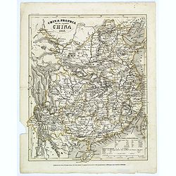
China-Propria oder das eigentliche China.
This map of China shows the mainland, and the islands of Formosa and Taiwan. This map is well engraved, with excellent topographical detail, but has minimal decoration.
Date: Hildburghausen, 1846
Selling price: ????
Please login to see price!
Sold in 2017
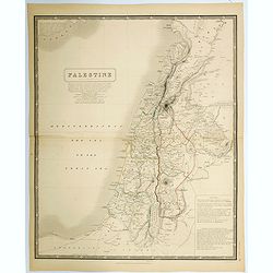
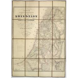
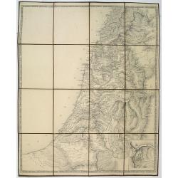
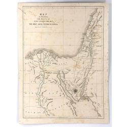
Palestine.
A large detailed map of the Holy Land, in fact, one of the largest maps of of this region to appear in a mid-19th century. Shows many towns, roads, rivers, mountains, lak...
Date: Edinburgh, 1846
Selling price: ????
Please login to see price!
Sold in 2021
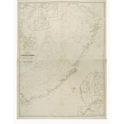
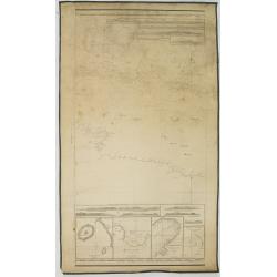
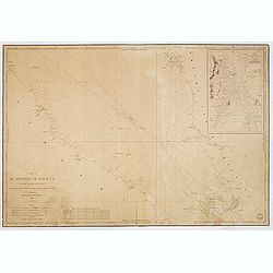
Chart to the coast of China from the Canton River to the Yang Tze Keang, prepared by John Walker, geographer to the Honble. East India Company.
Detailed chart to the coast of China, including Taiwan. The map has numerous insets (Hong Kong, River Woo-sung to Shanghai, Killon Harbour and Merope Bay Formosa, River M...
Date: London 1847
Selling price: ????
Please login to see price!
Sold
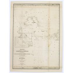
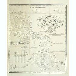
Kaart van de vaarwaters en eilanden tusschen Sumatra en Borneo. . .
Very large and rare centered on the island of Bangka, showing the southeastern coast of Sumatra.With large title surmounted by 4 small inset maps showing details of the ...
Date: Amsterdam, 1847
Selling price: ????
Please login to see price!
Sold
Carte Topographique de la Palestine dressée d'après la carte topographique levée par le savant Jacotin . . .
Uncommon folding map of the Holy Land published by Philip van der Maelen. Prepared by Jean van de Cotte after Jacotin and includes information gardened during expeditions...
Date: Brussels, 1847
Selling price: ????
Please login to see price!
Sold in 2013
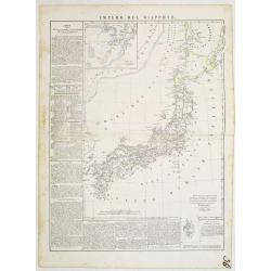
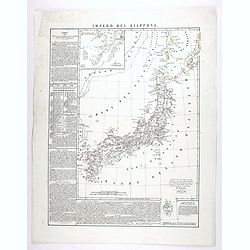
Impero del Giappone. Questa Carta e stata eseguita su quella pubblicata in Londra nel 1835, dalla Societa per la diffusione delle utili conoscenze, e su quella di Arrowsmith. . .
An interesting and uncommon detailed and large-scale Italian map of Japan published in Naples in Benedetto Marzolla's Atlante Geographico . Inset: Porto di Nangasaki (sca...
Date: Naples, 1847
Selling price: ????
Please login to see price!
Sold in 2011
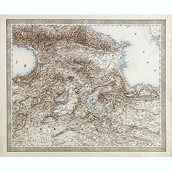
(Map of Armenia and Iran)
Detailed map of Armenia, Iran, Iraq and part of Turkey in elaborate floral borders. Joseph Scheda in Vienna 1845 - 1847.
Date: Vienna, 1845-1847
Selling price: ????
Please login to see price!
Sold in 2015
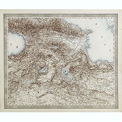
(Map of Armenia and Iran)
Detailed map of Armenia, Iran, Iraq and part of Turkey in elaborate floral borders. Published by Joseph Scheda in Vienna.
Date: Vienna, 1845-1847
Selling price: ????
Please login to see price!
Sold in 2021
No title, a folding map of Palistine.
A rare proof state of Jacotin's map Carte Topographique de la Palestine. . All text on this issue is not filled in yet. The map has been updated by Jean van de Cotte and ...
Date: Brussels, 1847
Selling price: ????
Please login to see price!
Sold in 2018
To Chas. Majoribanks esq.re and the other members of the hon.ble East India Company's factory at Canton, this Chart of Choo Keang or Canton river, is inscribed ... by James Horsburgh.
The chart stretches from north to south from Canton (Guangzhou) to Canzhou Island, and west to east from Dashi Bay to Hong Kong. Includes inset of Pearl River segment fro...
Date: July 1831 corrections to 1847
Selling price: ????
Please login to see price!
Sold in 2018
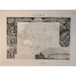
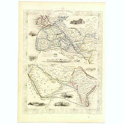
Oceanie, Description Historique Sur L'Ocean
A fine map of the southern Pacific Ocean, with decorative borders and views. Margin illustrations of excellent quality showing local peoples, explorers, products, landsca...
Date: Paris, 1847
Selling price: ????
Please login to see price!
Sold in 2020
Impero del Giappone. . .
An interesting and uncommon detailed and large-scale Italian map of Japan published in Naples in Benedetto Marzolla's Atlante Geographico . Inset: Porto di Nangasaki (sca...
Date: Naples, 1847
Selling price: ????
Please login to see price!
Sold in 2020
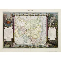
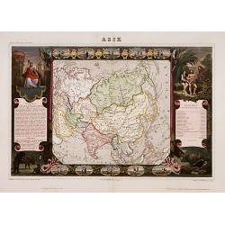
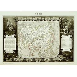
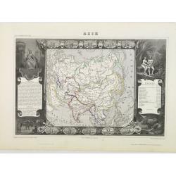
Asie.
Surround of vignettes, portraits, animals, vegetation, etc. One of the last decorative maps of the area. In original out-line color. The outer cartouches with later color...
Date: Paris 1848
Selling price: ????
Please login to see price!
Sold

Quelpartians.
Attractive scene depicting natives of Jeju (Quelpart) Island from Marryat’s “Borneo and the Indian Archipelago”. Marryat was a mid-shipman on the H.M.S. Samaran, wh...
Date: London, 1848
Selling price: ????
Please login to see price!
Sold in 2010
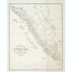
Carte de l'ile de Sumatra par le baron P.Melvill de Carnbee 1848. . .
Detailed map of Sumatra and the southern tip of Malacca with Singapore. Prepared in 1848 by baron P.Melvill de Carnbee and engraved by D.Heyse. From the rare work "L...
Date: The Hague, Belifante freres, 1848
Selling price: ????
Please login to see price!
Sold in 2013
Kaart der vaarwaters van Soerabaya naar de trigonometrische opname van den Luit. ter Zee M.H. Jansen. . .
Chart of Surabaya the capital of the province of East Java. Prepared by Lieutenant M.H. Jansen (1817-1893) and improved in 1848 by baron P.Melvill de Carnbee. Engraved in...
Date: The Hague, 1848
Selling price: ????
Please login to see price!
Sold in 2014
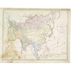
Karta öfver Asien.
An very rare map of Asia with Swedish text. This is an heavenly updated version of his map of 1817 and is now dated 1827, 1833.In lower part a color key to English, Frenc...
Date: A. Wiborgs förlag, Stockholm, ca. 1848
Selling price: ????
Please login to see price!
Sold in 2016
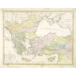
Karta öfver europeiska Turkiet och Mindre Asien.
An very rare map of Turkey with Greece and the Balkans still under Turkish occupation with Swedish text. This is an updated version of his map of 1821 and is now dated 18...
Date: A. Wiborgs förlag, Stockholm, ca. 1848
Selling price: ????
Please login to see price!
Sold in 2015

JUIVE DE CONSTANTINOPLE. Costumes de l'Empire Ottoman 3.
A beautiful hand colored lithograph of an elegant Jewish woman from Constantinople published in the French work "Galerie Royale de Costumes peints d´après nature p...
Date: Paris, Chez Aubert & Cie., 1842-1848
Selling price: ????
Please login to see price!
Sold in 2015

MARCHAND JUIF. A Constantinople. Costumes de l'Empire Ottoman 8.
A beautiful hand colored lithograph of a prominent Jewish merchant in Constantinople published in the French work "Galerie Royale de Costumes peints d´après nature...
Date: Paris, Chez Aubert & Cie., 1842-1848
Selling price: ????
Please login to see price!
Sold in 2015

FEMME TURQUE. Costumes de l'Empire Ottoman 10.
A beautiful hand colored lithograph of Turkish woman published in the French work "Galerie Royale de Costumes peints d´après nature par divers artistes et lithogra...
Date: Paris, Chez Aubert & Cie., 1842-1848
Selling price: ????
Please login to see price!
Sold in 2015

FEMME TURQUE VOILEE. Costumes de l'Empire Ottoman 6.
A beautiful hand colored lithograph of a Turkish veiled woman published in the French work "Galerie Royale de Costumes peints d´après nature par divers artistes et...
Date: Paris, Chez Aubert & Cie., 1842-1848
Selling price: ????
Please login to see price!
Sold in 2015

FEMME de DAMAR. Costumes Syriens 5.
A beautiful hand colored lithograph of an elegant Syrian woman from Damar published in the French work "Galerie Royale de Costumes peints d´après nature par divers...
Date: Paris, Chez Aubert & Cie., 1842-1848
Selling price: ????
Please login to see price!
Sold

CHALDEENE d'OURMYAHL. Costumes Persans 3.
A beautiful hand colored lithograph of a Chaldean woman from Ourmyahl published in the French work "Galerie Royale de Costumes peints d´après nature par divers art...
Date: Paris, Chez Aubert & Cie., 1842-1848
Selling price: ????
Please login to see price!
Sold

GRECQUE de SMYRNE. Costumes de l'Empire Ottoman 2.
A beautiful hand colored lithograph of a Greek woman from Smyrn published in the French work "Galerie Royale de Costumes peints d´après nature par divers artistes ...
Date: Paris, Chez Aubert & Cie., 1842-1848
Selling price: ????
Please login to see price!
Sold in 2015

KURDE de SOAUK-BOULAK. Costumes Persans 7.
A beautiful hand colored lithograph of a Kurd from Sauk Bolek published in the French work "Galerie Royale de Costumes peints d´après nature par divers artistes et...
Date: Paris, Chez Aubert & Cie., 1842-1848
Selling price: ????
Please login to see price!
Sold

AFGAHN d'HERAT. Costumes Persans 8.
A beautiful hand colored lithograph of an Afghan from Herat published in the French work "Galerie Royale de Costumes peints d´après nature par divers artistes et l...
Date: Paris, Chez Aubert & Cie., 1842-1848
Selling price: ????
Please login to see price!
Sold

MOLLAH ou PRETRE. Costumes Persans 4.
A beautiful hand colored lithograph of a Mollah published in the French work "Galerie Royale de Costumes peints d´après nature par divers artistes et lithographié...
Date: Paris, Chez Aubert & Cie., 1842-1848
Selling price: ????
Please login to see price!
Sold
Mapa general de las islas Philipinas Ano de 1849.
Provenance : Ex libris del Marqués de Pidal. Mapa Filipinas. 1847. N° 20. In lower left bottom a label : Junta delegada de incautacion proteccion y Salvamento del tesor...
Date: Spain, c. 1849
Selling price: ????
Please login to see price!
Sold in 2011
Verkenningen Genomen in de Wijnkoops-Baai.
A large so-called Blue-back chart of a part of Java, dated 1849, shows the results of local surveys in 1835-1849. No publisher mentioned (probably the Dutch Geographical ...
Date: Jakarta, 1849
Selling price: ????
Please login to see price!
Sold in 2008
Map to Illustrate the Route of David Roberts, Esq: R.A. in The Holy Land, Petrea, & Syria
A fine large format map from Roberts' The Holy Land, Syria, Idumea, Arabia, Egypt & Nubia.A map of Egypt, the Sinai, and the Holy Land, detailing the journey undertak...
Date: London, 1849
Selling price: ????
Please login to see price!
Sold in 2016
![[Bird's-Eye View of Petra] and [Ground Plan of Petra]](/uploads/cache/93803-250x250.jpg)
[Bird's-Eye View of Petra] and [Ground Plan of Petra]
Pair of steel engravings from "Forty days in the desert on the track of the Israelites, or, A journey from Cairo by Wady Feiran to Mount Sinai and Petra", in th...
Date: London, 1849
Selling price: ????
Please login to see price!
Sold in 2014
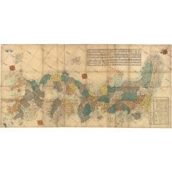
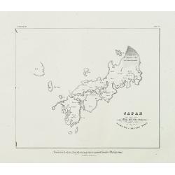
Map of the Districts and Countries of Great Japan
This is a spectacular, large format folding map of Japan by Takashiba Ei'San'Yu, dated 1849. The map presents the primary Japanese islands of Kyushu, Honshu, Shikoku and ...
Date: Japan, 1849
Selling price: ????
Please login to see price!
Sold in 2023
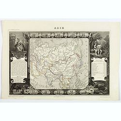
Asia.
A very decorative 19th century map of Asia. The map is surrounded by vignettes, portraits, animals, vegetation, etc.
Date: Paris 1850
Selling price: ????
Please login to see price!
Sold
Asie
A decorative 19th century map of the continent. The map is surrounded by steel engraved vignettes depicting costumes of the various peoples of Asia, Adam and Eve, and sev...
Date: Paris 1850
Selling price: ????
Please login to see price!
Sold
Asie.
A decorative 19th century map of the continent. The map is surrounded by steel engraved vignettes depicting costumes of the various peoples of Asia, Adam and Eve, and sev...
Date: Paris 1850
Selling price: ????
Please login to see price!
Sold
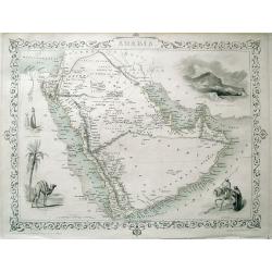
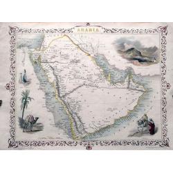
ARABIA.
Detailed map of the Arabian Peninsula, Persian Gulf, and the Red Sea. With numerous place names, and several routes through the desert shown. Highly decorative map with ...
Date: London, c1850
Selling price: ????
Please login to see price!
Sold in 2013
![[Edo period woodcut plan of Edo or Tokyo]](/uploads/cache/27903-250x250.jpg)
[Edo period woodcut plan of Edo or Tokyo]
Nice plan of Edo (present-day Tokyo) oriented with north to the right. Shows main temples and shrines pictorially. Includes distance chart and legend. In color, folded, l...
Date: Japan c. 1850
Selling price: ????
Please login to see price!
Sold in 2009
Independent Tartary.
A charming map of Tartary published in London, 1851. The last of the decorative maps.
Date: London, 1850
Selling price: ????
Please login to see price!
Sold in 2010
ARABIA.
Detailed map of the Arabian Peninsula. With numerous place names, and several routes through the desert. Highly decorative map with an inset view of Mount Sinai, scenes...
Date: London, c1850
Selling price: ????
Please login to see price!
Sold in 2013
Carte de la côte nord de Java (de la pointe d'Intramayoe au détroit de Sourabaya). . .
Great large-scale sea-chart of a part of northern Java and the Java Sea. Shows the area from Indramayu to Surabaya, including Karimunjawa and Bawean. With numerous depth ...
Date: Paris, 1850
Selling price: ????
Please login to see price!
Sold in 2014
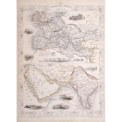
Overland Route to India.
Steel engraved map of the Overland Route to India. The illustrations are by H Warren and engraved by J H Kernot, the map engraved by J Rapkin. Published by John Tallis. T...
Date: London, 1850
Selling price: ????
Please login to see price!
Sold in 2014
Constantinople and the Bosphorus.
A detailed map of Istanbul and the Bosphorus. With many place names, and two insets: One of the Mosque of St. Sophia; and one of the Princess islands.
Date: London, c1850
Selling price: ????
Please login to see price!
Sold in 2014

Kamchatka according to A.Erman . . .
FIRST EDITION Map of the Kamchatka Peninsula, Siberia, from Gazetteer of the World. Drawn by Augustus Petermann, engraved by G. H. Swanston.
Date: London / Edinburgh, 1850
Selling price: ????
Please login to see price!
Sold in 2025
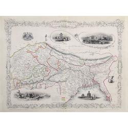
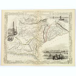
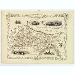
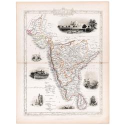
Northern India
A very decorative steel-engraved map of a portion of India including Nepal, Bhutan, and modern day Bangladesh. Very detailed with place names, rivers, hills, bays, lakes,...
Date: London, ca.1850
Selling price: ????
Please login to see price!
Sold in 2017
Asie.
Charming map of the continent, surrounded by animals and people dressed in their traditional clothing. Columns on the sides contain text and numbers of population of the ...
Date: Paris, ca. 1850
Selling price: ????
Please login to see price!
Sold in 2020
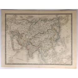
Asie.
A fine detailed map of Asia by Louis Antoine, published in Paris in about 1850.
Date: Paris, ca. 1850
Selling price: ????
Please login to see price!
Sold in 2017
![Ansei kaisei fugo on Edo ezu. [Tokyo]](/uploads/cache/40776-250x250.jpg)
Ansei kaisei fugo on Edo ezu. [Tokyo]
An extraordinary color-printed town-plan now-a-day Tokyo, and a fine example of Edo cartography. The present map is exceptionally detailed with accurate delineations of d...
Date: Edo, ca. 1850
Selling price: ????
Please login to see price!
Sold in 2017
![[Plan of Edo / Tokyo.]](/uploads/cache/41893-250x250.jpg)
[Plan of Edo / Tokyo.]
A fascinating and impressive town plan of Edo/Yedo in Japan, during the Tokugawa Shogunate of the 1850s. After 1868, Yedo was renamed Tokyo.The publisher Owariya produced...
Date: Tokyo, ca. 1850
Selling price: ????
Please login to see price!
Sold in 2020
Constantinople and the Bosphorus.
A detailed map of Istanbul and the Bosphorus. With many place names, and two insets: One of the Mosque of St. Sophia; and one of the Princess islands. By Findlay in Londo...
Date: London, 1850
Selling price: ????
Please login to see price!
Sold in 2018
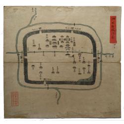
Sizhou city, Jiangsu Province.
An original Qing Dynasty era Chinese manuscript map of Sizhou city in Jiangsu province, China.Sizhou was destroyed by floods during emperor Kangxi reign about 300 years a...
Date: China, ca. 1850
Selling price: ????
Please login to see price!
Sold in 2019
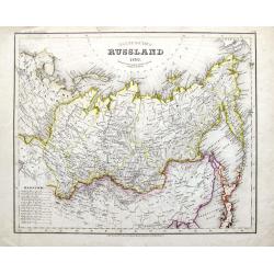
Asiatisches Russland 1850.
A highly detailed map of Russia with parts of China and Japan. Filled with topographical information. From Meyers Grosser Zeitungs-Atlas, the most important German Atlas ...
Date: Hildburghausen, 1850
Selling price: ????
Please login to see price!
Sold in 2019
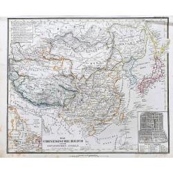
Das Chinesische Reich und die Japanischen Jnseln.
A fine steel-engraved map from a scarce German Atlas: 'Schuberth's Hand-Atlas'. It shows China, Korea and Japan, as well as surrounding areas including Mongolia, Siberia,...
Date: Nuremberg, ca 1850
Selling price: ????
Please login to see price!
Sold in 2021
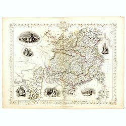
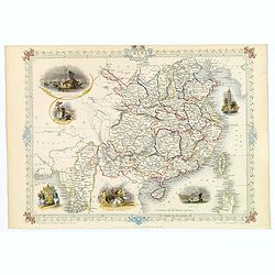
China and Birmah.
A highly decorative and detailed map of China and Burma which was drawn and engraved by J. Rapkin (vignettes by A. H. Wray & J. B. Allen).Showing British Factories in...
Date: London & New York: John Tallis & co, c.1851
Selling price: ????
Please login to see price!
Sold in 2017
China and Birmah.
A highly decorative and detailed map of China and Burma drawn and engraved by J. Rapkin.Drawn by A.H. Wray and J.B. Allen, the map's vignettes include British factories i...
Date: London & New York, c. 1851
Selling price: ????
Please login to see price!
Sold in 2018
Northern India.
Decorative steel engraved map of Northern India, surrounded 6 decorative vignettes.Taken from "The illustrated atlas and modern history of the world by John Tallis&q...
Date: London, 1851
Selling price: ????
Please login to see price!
Sold in 2018
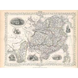
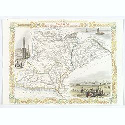
Cabool, the Punjab and Beloochistan.
Decorative steel engraved map of Cabool, the Punjab and Beloochistan, surrounded 3 large, decorative vignettes.Taken from "The illustrated atlas and modern history o...
Date: London, 1851
Selling price: ????
Please login to see price!
Sold in 2017
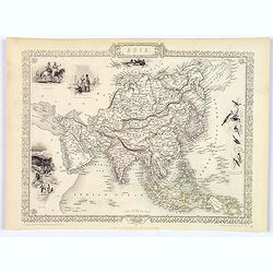
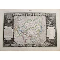
Asia.
The lovely map of Asia by John Tallis, characterised by its decorative border, and numerous delicate vignettes surrounding the map itself. West from Turkey in Asia across...
Date: London, 1851
Selling price: ????
Please login to see price!
Sold in 2017
Overland Route to India.
Decorative steel engraved map of the Overland Route to India, surrounded 8 decorative vignettes.Taken from "The illustrated atlas and modern history of the world by ...
Date: London, 1851
Selling price: ????
Please login to see price!
Sold in 2020
China and Birmah.
A highly decorative and detailed map of China and Burma which was drawn and engraved by J. Rapkin (vignettes by A. H. Wray & J. B. Allen).Showing British Factories in...
Date: London, Edinburgh & Dublin 1851
Selling price: ????
Please login to see price!
Sold in 2019
Cabool, the Punjab and Beloochistan.
A decorative steel engraved map of Cabool, the Punjab and Beloochistan, surrounded 3 large, colored, decorative vignettes.Taken from "The illustrated atlas and moder...
Date: London, 1851
Selling price: ????
Please login to see price!
Sold in 2020
Northern India.
Decorative steel engraved map of Northern India, surrounded 6 decorative vignettes.Taken from "The illustrated atlas and modern history of the world by John Tallis&q...
Date: London, 1851
Selling price: ????
Please login to see price!
Sold in 2020
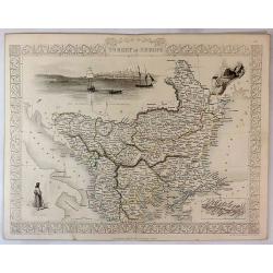
Turkey in Europe.
A striking map of European Turkey by John Tallis. It features decorative vignettes of Ali Pasha, The Bosphorus and Constantinople and a Greek Caloyer figure. There is als...
Date: London, 1851
Selling price: ????
Please login to see price!
Sold in 2019
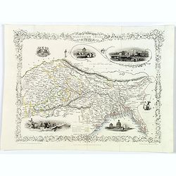
Southern India.
Original steel engraved map of Southern India. Several vignette scenes, including Shuhur, Jeypoor, Calcutta and Bejapoor. Decorative scrolling and title cartouche around ...
Date: London, Edinburgh & Dublin: J & F Tallis, 1851
Selling price: ????
Please login to see price!
Sold in 2020

Portrait of Otaksa.
Fine portrait of Otaksa, published in Nippon . Von Siebold was born in Wurtzburg, in Germany, and worked for the Dutch government as a doctor in Java. In Japan, where Von...
Date: Leiden, 1832-1852
Selling price: ????
Please login to see price!
Sold in 2009
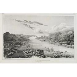
Gezigt op de haven en de baai van Nagasaki.
A birds-eye view showing Deshima, the trading post of the V.O.C., and Nagasaki bay. Von Siebold was born in Würtzburg, in Germany, and worked for the Dutch government as...
Date: Leiden, 1832-1852
Selling price: ????
Please login to see price!
Sold in 2010

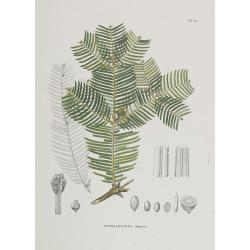
Acer micranthum.
From his famous work 'Flora Japonica'. Von Siebold was born in Würtzburg, in Germany, and worked for the Dutch government as a doctor in Java. In Japan, where Von Siebol...
Date: Leiden, 1852
Selling price: ????
Please login to see price!
Sold in 2009
Cephalotaxus drupacea.
From his famous work 'Flora Japonica'. Von Siebold was born in Würtzburg, in Germany, and worked for the Dutch government as a doctor in Java. In Japan, where Von Siebol...
Date: Leiden, 1852
Selling price: ????
Please login to see price!
Sold in 2009
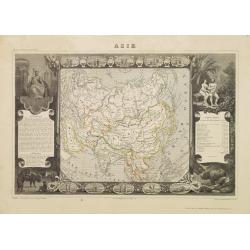
Asie.
Map of Asia framed by vignettes depicting costumes of the various peoples of Asia, Adam and Eve, and several exotic animals. Interesting population chart at right totalin...
Date: Paris, A. Combette, 1852
Selling price: ????
Please login to see price!
Sold in 2009

Het Japansche Ryk. De Voornaamste Eilanden van Hetzelve Zijn. Das Japanische Reich. Die vorzügliehsten Inseln desselben . . . Neben und Schutzländer.
A table prepared by Von Siebold showing the names of the different Japanese islands in Japanese and Latin.Von Siebold was born in Wurzburg, in Germany, and worked for the...
Date: Leiden, 1832-1852
Selling price: ????
Please login to see price!
Sold in 2010
Japan ten tyde van Zin-mu-ten-woo 660 v.c.
Historical map of Japan for the year 660 B.C., during the regime of Zin-mu-ten-woo. According to the map Japan was known as "Jama-to v. Aki-Tsu-Sima.The tip of Korea...
Date: Leiden 1832-1852
Selling price: ????
Please login to see price!
Sold in 2014

Muzijkinstrumenten - Samisen / Kokiu.
A japanese woman playing the samisen and a men playing kokiu.Von Siebold was born in Würtzburg, in Germany, and worked for the Dutch government as a doctor in Java. In J...
Date: Leiden, 1832-1852
Selling price: ????
Please login to see price!
Sold in 2012

KOORAI. Kumtsjun. Nippon VII. TAB. VIII.
Kumtsjun from Korea, lithography from his very rare book "Nippon".Philipp Franz von Siebold (1796-1866) was a physician, researcher and teacher who joined the D...
Date: Leiden, 1852
Selling price: ????
Please login to see price!
Sold

KOORAI. Hosatsem. Nippon VII. TAB. IX.
Hosatsem from Korea, lithography from his very rare book "Nippon".Philipp Franz von Siebold (1796-1866) was a physician, researcher and teacher who joined the D...
Date: Leiden, 1852
Selling price: ????
Please login to see price!
Sold

MUZJIKINSTRUMENTEN. MUSIKINSTRUMENTE. Tab.V.
Several Japanese instruments.Philipp Franz von Siebold (1796-1866) was a physician, researcher and teacher who joined the Dutch East Indian army and travelled to Japan on...
Date: Leiden, 1852
Selling price: ????
Please login to see price!
Sold in 2021
Asie.
A decorative map of Asia framed by glorious vignettes depicting costumes of the various peoples of Asia Adam and Eve, and several exotic animals. With an interesting popu...
Date: Paris, 1852
Selling price: ????
Please login to see price!
Sold in 2019
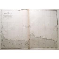
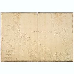
Carte du détroit de Malacca. Partie Septentrionale comprenant depuis Poulo Penang jusqu'au Mont Parcelar. . .
Detailed chart depicting the strait of Malacca and the north west coast of Malaysia, from the island Pulau Pinang to Pelabuhan Klang west of Kuala Lumpur.With inset chart...
Date: Paris, 1843 updated to 1853
Selling price: ????
Please login to see price!
Sold in 2013
Carte du détroit de Malacca. Partie Méridionale comprenant depuis le Mont Parcelar jusqu'à Singapoure.
Detailed chart depicting the strait of Malacca and the southern tip of Malaysia, including the island Singapore.The chart was actually used and has some lead pencil annot...
Date: Paris, 1843 updated to 1853
Selling price: ????
Please login to see price!
Sold in 2013