Subscribe to be notified if similar examples become available.
Map of the Districts and Countries of Great Japan |
||||||||||||||||||||
|
||||||||||||||||||||
|
|
||||||||||||||||||||
|
Selling price: $ Please login to see price!
Sold in 2023 Missed this item! Add your name to our mailing list and be the first to get notified about our newly added listings. . |
My Collection + - Save and collect this or any of your favorite items in one place.
If you want to save the items permanently, please sign in or create account first.
Watchers:
5
|
|||||||||||||||||||
Description
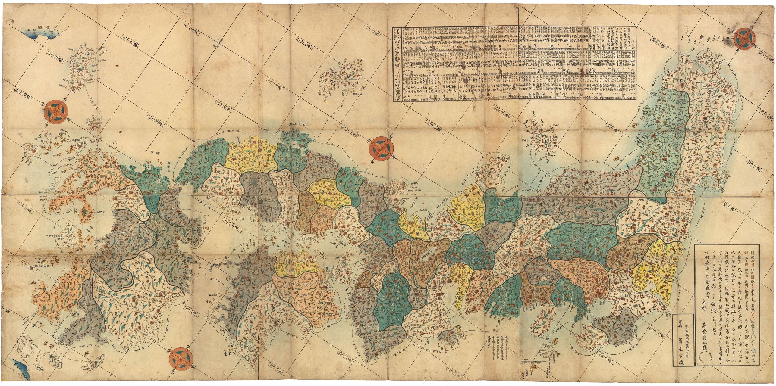
This is a spectacular, large format folding map of Japan by Takashiba Ei'San'Yu, dated 1849. The map presents the primary Japanese islands of Kyushu, Honshu, Shikoku and a number of small surrounding islands in a northwestern orientation. It is divided by provinces (kuni or country, here just translated as country) and districts. Main roads, and sea routes with distances are delineated throughout the map.
The purpose of the map seems to draw attention to touristy destinations. The author seems to apologizing for not listing more temples and hot springs etc. and advises the reader on how to find more. The Tokugawa period was a period of unprecedented stability for Japan which allowed for a tourism industry to grow. This map came out not too long after Hiroshige's famous travel art 53 stations of Tokaido, a series of prints that illustrated that journey along the imperial road from Edo (modern Tokyo) to the emperor's palace in Kyoto.
In his note Takashiba Ei'San'Yu talks about following the Ekiro (lit. post road), these were a network of highways that were established in the Ritsuryo system during the Asuka period (538-710). These were primarily for emergencies and official business and ran in mostly straight lines throughout administrative districts of Japan (the five home districts and seven circuits as they were called) which were also established during this period. The names of these administrative districts and the highways that run through them – such as Tokaido – have stuck around even if the borders have shifted.
The table in the top right provides distances to the country of Musashi and the various countries of Edo. The boxes inside the table list a larger region and then a town within it followed by the distance.
FAQ - Guarantee - Shipping
994 BuyBidBuying in the BuyNow Gallery
This item is available for immediate purchase when a "Add to Cart" or "Inquire Now" button is shown.
Payments are accepted in Euros or US Dollars. We accept most major credit cards, PayPal and bank transfer.
Authenticity Guarantee
 We provide professional descriptions, condition report and HiBCoR rating (based on 45 years experience in the map business)
We fully guarantee the authenticity of items we sell. We provide a certificate of authenticity for each purchased item.
Condition / Coloring
We indicate the condition of each item and use our unnique HiBCoR grading system in which four key items determine a map's value: Historical Importance, Beauty, Condition/Coloring and Rarity.
We offer many maps in their original black and white condition. We do not systematically color-up maps to make them more sellable to the general public or buyer.
Copper engraved or wood block maps are always hand colored. Maps were initially colored for aesthetic reasons and to improve readability. Nowadays, it is becoming a challenge to find maps in their original colors and are therefor more valuable.
We use the following color keys in our catalog:
Original colors; mean that the colors have been applied around the time the map was issued.
Colored; If the colors are applied recently or at the end of the 20th century, then "colored", or "attractive colors" will be used.
Original o/l colors; means the map has only the borders colored at the time of publication.
Read more about coloring of maps [+]
FAQ
Please have a look for more information about buying in the BuyNow gallery.
Many answers are likely to find in the general help section.
My Collection+
![]()
With My Collection+ you can collect all your favorite items in one place. It is free, and anyone can create his or her virtual map collection.
Unless you are logged in, the item is only saved for this session. You have to be registed and logged-in if you want to save this item permanently to My Collection+.
Read More [+]
If you want to save the items permanently, please sign in
or create account first. ![]()
Registering Here, it is and you do not need a credit card.
Add this item to
My Collection+
or click the following link to see My Collection+.
Invoice
The invoice and certificates of authenticity are available in the client center >Invoices
| Digital Image Download | |
|
Paulus Swaen maintains an archive of most of our high-resolution rare maps, prints, posters and medieval manuscript scans. We make them freely available for download and study. Read more about free image download |
Click the image for a free small image download. |
In accordance with the EU Consumer Rights Directive and habitually reside in the European Union you have the right to cancel the contract for the purchase of a lot, without giving any reason.
The cancellation period will expire 14 calendar days from the day after the date on which you or a third party (other than the carrier and indicated by you) acquires, physical possession of the lot. To exercise the right to cancel you must inform Paulus Swaen Inc, of your decision to cancel this contract by a clear statement (e.g. a letter sent by post, or e-mail (amsterdam@swaen.com).
To meet the cancellation deadline, it is sufficient for you to send your communication concerning your exercise of the right to cancel before the cancellation period has expired.
