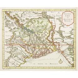
Browse Listings in Asia
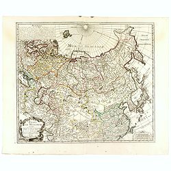
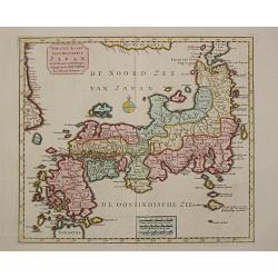
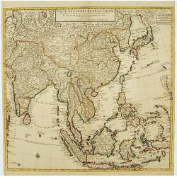
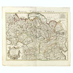
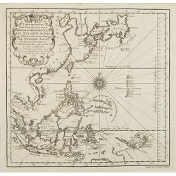
Etats de Moscovie. . .
Fine and rare map of Russia, Siberia, China, Korea and Japan. George Louis Le Rouge was active between 1740 and 1780, in Paris at, rue des Augustins as a publisher, and w...
Date: Paris, 1744
Selling price: ????
Please login to see price!
Sold in 2023
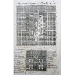
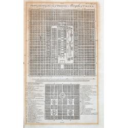
Plans of the Old & New City of Peking ye Metropolis of China.
Two plans of the city, on top new Peking, and below ancient Peking. An extensive legend key identifies around 49 important places such as the Emperor’s residence, remar...
Date: London, 1744
Selling price: ????
Please login to see price!
Sold in 2017
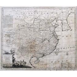
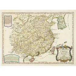
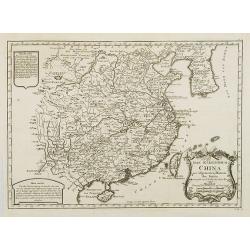
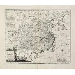
A New & Accurate Map of China.
Emanuel Bowen's map of China based on D'Anville's earlier work.Includes the Korean peninsula, Formosa (Taiwan), and Hainan. With an explanation legend, and text informati...
Date: London, 1744
Selling price: ????
Please login to see price!
Sold in 2017
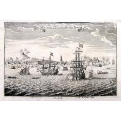
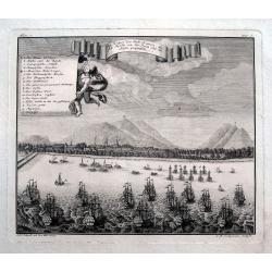
A View of the Town and Castle of Macao.
Nice view of the town seen from the sea. Numerous buildings and ships shown. With the British ship Centurion in the foreground firing cannons, and the return fire is seen...
Date: London, 1744
Selling price: ????
Please login to see price!
Sold in 2018
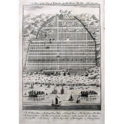
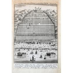
A Plan of the City of Canton on the River Ta ho.
An early plan of Guangzhou, with many buildings and ships shown. A key names 13 places, including the King's Palace, Young Kings's Palace, The City Wall, and two Floating...
Date: London, 1744
Selling price: ????
Please login to see price!
Sold in 2017
A Map of Marco Polo's Voyages & Travels in the 13th Century through a great part of Asia, all Tartary, the East India Islands & Part of Africa.
This unusual map depicts the areas in Asia where Marco Polo traveled in the 13th century. Japan is shown as a peninsula connected to Land of Yeso! With a decorative title...
Date: London, 1744
Selling price: ????
Please login to see price!
Sold in 2017
Solomon Built the House of the lord on the Mount Where the Lord Appeared to David His Father. II Chronicle, Chapter III, Verse 1.
A fine religious print from a Bible in 1762. There are eight separate images including “The Temple of Solomon”, "The Tabernacle in the Wilderness", "Th...
Date: London, 1744
Selling price: ????
Please login to see price!
Sold in 2019
Ein Prospect der Stadt Batavia, wie sich dieselbe von der Reede oder dem Hafen praesentiret.
An uncommon view of Batavia (today known as Jakarta) shown from the sea, which was the main city of the Dutch East India Company (the VOC). The harbour is filled with sai...
Date: Nuremberg, 1744
Selling price: ????
Please login to see price!
Sold in 2018
Plans of the Old & New City of Peking ye Metropolis of China.
Two early plans of the city, on top the new Peking, and below the ancient Peking. With an extensive legend key that identifies around 49 important places such as the Empe...
Date: London, 1744
Selling price: ????
Please login to see price!
Sold in 2021
A Plan of the City of Canton on the River Ta ho.
An early and decorative plan of Guangzhou, with many buildings and ships shown. A key names 13 places, including the King's Palace, Young Kings's Palace, The City Wall, a...
Date: London, 1744
Selling price: ????
Please login to see price!
Sold in 2021
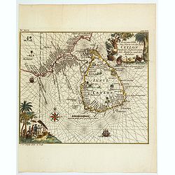
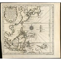
Accurater Plan u See-Charte von der Inful Ceylon..
A fine and decorative map of Ceylon and southern tip of India, presented as a sea chart. Scarce. From Allerneuster geographisch- und topographischer Schau-Platz von Afric...
Date: Germany, 1744
Selling price: ????
Please login to see price!
Sold in 2021
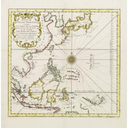
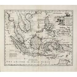
A large Draught of the East End of Java and Madura. . .
Oriented with west at the top, this large-scale and detailed chart of the Bali Strait and Java Sea, shows the eastern ends of Java and Madura, and the western end of Bali...
Date: London 1745
Selling price: ????
Please login to see price!
Sold in 2023
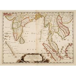
Partie Meridionale de l'Inde en deux presqu'isles..
An uncommon late printing of the Sanson's important mid-seventeenth century map of India and Southeast Asia, with the engraved date 1703 (apparently the second and last s...
Date: Paris 1703/c.1745
Selling price: ????
Please login to see price!
Sold
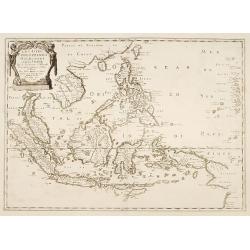
Les Isles Philippines Molucques et de la Sonde.
An uncommon late printing of Sanson's important mid-seventeenth century map of the East Indies, covering modern Indonesia, the Philippines, Malaysia and parts of Southeas...
Date: Paris 1654/c.1745
Selling price: ????
Please login to see price!
Sold
A large Draught from Benjar on the Island of Borneo..
A later edition, printers address erased from the title cartouche. Latitude scale, compass rose and system of rhumb lines, soundings near coast.
Date: London 1745
Selling price: ????
Please login to see price!
Sold
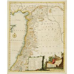
A map of the Holy Land and Syria.
Uncommon map of the Holy Land. With a key and decorative title cartouche in bottom. Published in Description of the East .
Date: London 1745
Selling price: ????
Please login to see price!
Sold
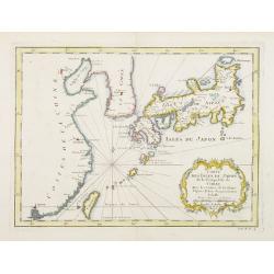
Nieuwe Kaart van t Keizerryk Japan.
Izaak Tirion (d. 1769) Amsterdam publisher. His ' Nieuwe en beknopte handatlas' saw 6 editions between before 1740 and after 1784. Also ' Tegenwoordige staat van alle vol...
Date: Amsterdam, c. 1745
Selling price: ????
Please login to see price!
Sold in 2015
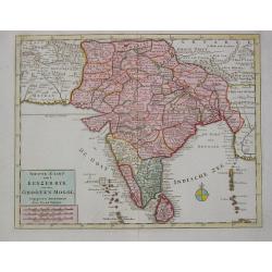
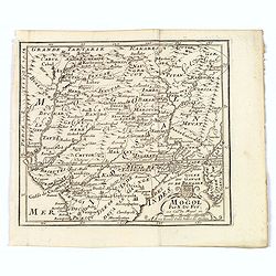
Nieuwe Kaart van t Keyzer Ryk van den Grooten Mogol.
Izaak Tirion (d. 1769) Amsterdam publisher. His ' Nieuwe en beknopte handatlas' saw 6 editions between before 1740 and after 1784. Also ' Tegenwoordige staat van alle vol...
Date: Amsterdam, c. 1745
Selling price: ????
Please login to see price!
Sold
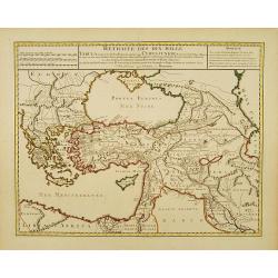
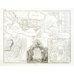
Retraite des Dix Mille..
Very decorative map of the Near East: it represents the area which was the theatre of the Ten Thousand's march to the Battle of Cunaxa and back to Greece (401 BC-399 BC),...
Date: Amsterdam c. 1745
Selling price: ????
Please login to see price!
Sold
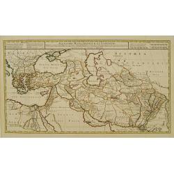
Alexandri Magni Imperium et Expeditio.
The map represents the theatre of Alexander the Great's conquests between the Black Sea and Indus River, today's Armenia, Iraq, Iran, Afghanistan, etc.The map is from a D...
Date: Amsterdam c. 1745
Selling price: ????
Please login to see price!
Sold
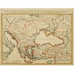
Imperii Orientalis et Circumjacentium Regionum. .
Very decorative copper-engraved map representing the extent of Constantine VII Porphyrogenitos' empire.The map is from a Dutch edition of De L'Isle's work entitled, Atlas...
Date: Amsterdam c. 1745
Selling price: ????
Please login to see price!
Sold
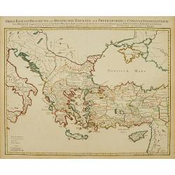
Orbis Romani Descriptio seu Divisio per Themata. .
Covens and Mortier's Map of the Roman World is a copperplate engraving based on an earlier map by Guillelmo De L'Isle (1675-1726), Geographer to the King of France. The s...
Date: Amsterdam c. 1745
Selling price: ????
Please login to see price!
Sold
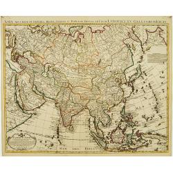
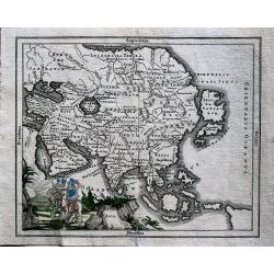
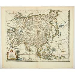
Carte d'Asie dressée sur les Mémoires..
Highly detailed map of Asia, based upon earlier maps by De L'Isle. With charming title cartouche and inset of the north easternmost part of Russia.The map is from a Dutch...
Date: Amsterdam c. 1745
Selling price: ????
Please login to see price!
Sold
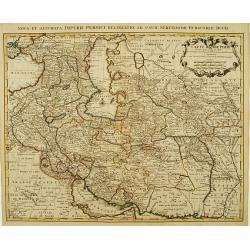
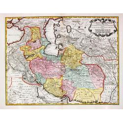
Carte de Perse dressée pour l'usage du Roy..
Detailed map of Persia embellished with a title cartouche featuring the French crown and coat of arms. Relief shown pictorially.The map is from a Dutch edition of De L'Is...
Date: Amsterdam, c. 1745
Selling price: ????
Please login to see price!
Sold in 2008
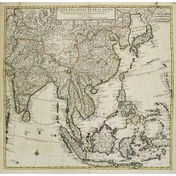
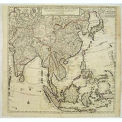
Carte des Indes et de la Chine Dressée..
Large and attractive map of the East Indes, India and China.The map is from a Dutch edition of De L'Isle's work entitled, Atlas Nouveau, Contenant Toutes Les Parties Du M...
Date: Amsterdam c. 1745
Selling price: ????
Please login to see price!
Sold
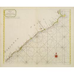
A new chart of the coast of ORIXA and GALCONDA. Carefully corrected and compared with the French charts.
Interesting and detailed navigational chart of southern part of India.
Date: London 1745
Selling price: ????
Please login to see price!
Sold
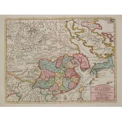
Nouvelle Carte de l'Empire de la Chine et les Païs circomvoisins.
A map of China by Izaak Tirion, also showing Korea and Japan.Isaak Tirion (d. 1769) Amsterdam publisher. His "Nieuwe en beknopte handatlas" saw 6 editions betwe...
Date: Amsterdam, c. 1745
Selling price: ????
Please login to see price!
Sold in 2019
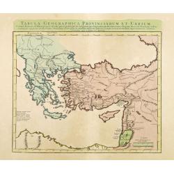
Tabula Geographica Provinciarum et Urbium Colonia Romana..
Covens and Mortier's Map of the Roman World is a copperplate engraving based on an earlier map by Guillelmo De L'Isle (1675-1726)Engraved map in outline color. Relief sho...
Date: Amsterdam c. 1745
Selling price: ????
Please login to see price!
Sold in 2012
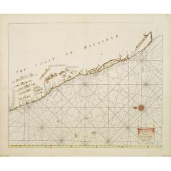
A Large Draught of the Mallabar Coast..
Important chart of the coast centred on Calcutta. From the East India Pilot . Detailed map with compass roses and system of rhumb lines, soundings and anchorage's. Many p...
Date: London 1745
Selling price: ????
Please login to see price!
Sold
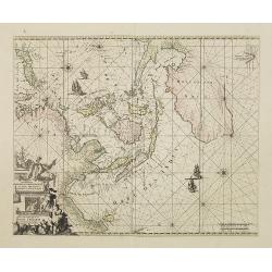
Orientaliora Indiarum Orientalium. . .
This is a corrected version of De Wit. Tasmania is inserted, and New Britain with Dampier's route 1700, now changes the shape of New Guinea. The chart has also been corre...
Date: Amsterdam, 1745
Selling price: ????
Please login to see price!
Sold in 2008
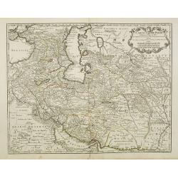
Carte de Perse dressée pour l'usage du Roy. . .
Detailed map of Persia embellished with a title cartouche featuring the French crown and coat of arms. Prepared by one of the major key figures in the development of Fren...
Date: Paris, 1745
Selling price: ????
Please login to see price!
Sold
Carte de Perse dressée pour l'usage du Roy. . .
Detailed map of Persia embellished with a title cartouche featuring the French crown and coat of arms. Prepared by one of the major key figures in the development of Fren...
Date: Paris, 1745
Selling price: ????
Please login to see price!
Sold in 2009
Carte des Indes et de la Chine Dressée . . .
Large and attractive map of South East Asia, India and China.The map is of interest for the use of East Sea, the sea between Korea and Japan, here called "Mer Orient...
Date: Amsterdam, c. 1745
Selling price: ????
Please login to see price!
Sold
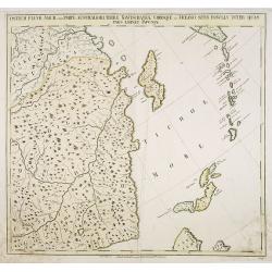
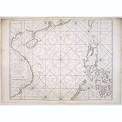
Ostium Fluvii Amur cum parte australiori terrae Kamtschatkae variisque in Oceano sitis Insulis inter quas pars eminet Japoniae. No.19
Detailed map of part of Siberia in Russia, including in the lower right part the Northern tip of Hokkaido and in the upper right corner the southern tip of Kamchatka. The...
Date: Petersburg, 1745
Selling price: ????
Please login to see price!
Sold in 2009
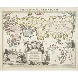
Imperium Japonicum Per Regiones Digestum Sex et Sexaginta Atque Ipsorum Japonensium Mappis Descriptum Ab Hadriano Relando.
Prepared by H.Reland (1676-1718) a professor active in Utrecht and specialized in Asian languages, geography and religions. His first map was a map of Japan copied after ...
Date: Amsterdam, 1745
Selling price: ????
Please login to see price!
Sold
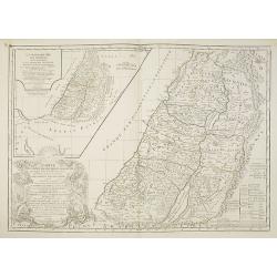
La Monarchie des Hebreux sous Salamon, ou le royaume D'Israel. . . / Carte de la terre des Hebreux ou Israelites. . .
Two maps of the Holy Land on one sheet representing the Monarchy of the Hebrews under Solomon divided into 12 governments. The Kingdom of Solomon includes not only Palest...
Date: Paris, 1745
Selling price: ????
Please login to see price!
Sold in 2011
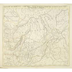
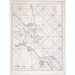
Territorii Iacutensis pars orientalior cum maxima parte terrae Kamtschatkae.
Detailed map of part of Siberia, including Kamtschatka. In the upper right corner an inset map 115x130mm of Siberia. The map was prepared by Joseph Nicolas De L'Isle and ...
Date: Petersburg, 1745
Selling price: ????
Please login to see price!
Sold in 2010
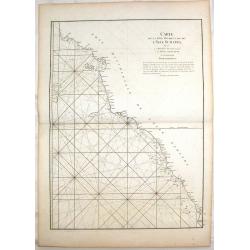
Irkutensis vice praefectura cum Mari Baikal, et fonte Fluvü Lenae, partibusque Fluviorum Argun et Amur. N. 17.
Detailed map of part of Siberia, including Baikal lake and Irkuck. The map was prepared by Joseph Nicolas De L'Isle and was included in "Atlas Russicus". The Ru...
Date: Petersburg, 1745
Selling price: ????
Please login to see price!
Sold in 2010
![The History of the Court of the King of China [with] An Account of the Empire of China. . .](/uploads/cache/99680-250x250.jpg)
The History of the Court of the King of China [with] An Account of the Empire of China. . .
Complete account extracted from a contemporary collection of voyages in French and Spanish and translated into English. Includes a map of China by Herman Moll.
Date: London, 1745
Selling price: ????
Please login to see price!
Sold in 2012
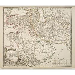
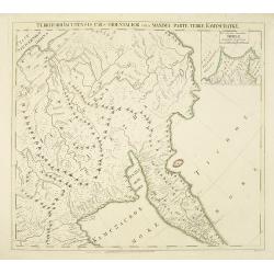
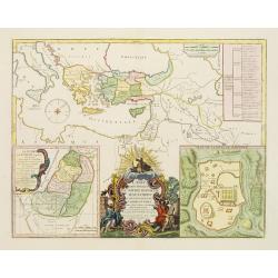
Etats du Grand-Seigneur en Asie, Empire de Perse, Pays des Usbecs, Arabie et Egypte.
Detailed map of the region bounded by the Black Sea, Georgia, the Caspian, Uzbekistan, The Indian Ocean, Saudi Arabia ("Arabie Heureuse"), Egypt, and the Red Se...
Date: Paris, c.1745
Selling price: ????
Please login to see price!
Sold in 2010
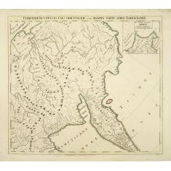
Territorii Iacutensis pars orientalior cum maxima parte terrae Kamtschatkae.
Detailed map of part of Siberia, including Kamtschatka. In the upper right corner an inset map 115x130mm of Siberia. The map was prepared by Joseph Nicolas De L’Isle an...
Date: Petersburg, 1745
Selling price: ????
Please login to see price!
Sold in 2010
Carte des Indes et de la Chine Dressée . . .
Large and attractive map of South East Asia, India and China.The map is of interest for the use of East Sea, the sea between Korea and Japan, here called "Mer Orient...
Date: Amsterdam, c. 1745
Selling price: ????
Please login to see price!
Sold in 2012
Carte plate qui comprend les Costes de Tsiompa, de la Cochinchine, le golfe de Tunquin, une partie des costes de la Chine avec une partie de l'Archipel des Isles Philippines. . .
Important French of the China Sea with the coast of Southern China, including Hong Kong and the southern tip of Taiwan. Great detail on the Philippines.Engraved by Guill...
Date: Paris, Jean-François Robustel, 1745
Selling price: ????
Please login to see price!
Sold
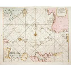
Carte des mers comprises entre le détroit de Banca et P°. Timon avec la partie orientale du détroit de Malacca.
Important French chart of the tip of Malaysia with Singapore.Latitude and longitude scales, compass rose and system of rhumb lines, soundings near coast and in bay areas....
Date: Paris, Jean-François Robustel, 1745
Selling price: ????
Please login to see price!
Sold in 2014
Carte de la Cote Occidentale de L'isle Sumatra.
Coastal Map of West Sumatra, an island in Western Indonesia. It is from Le Neptune Oriental. Jean-Baptiste d'Après de Mannevillette (1707-1780) was a French sailor, nav...
Date: Paris, 1745
Selling price: ????
Please login to see price!
Sold in 2018
Carte de Tartarie Dressée sur les Relations de plusieurs Voyageurs. . .
Detailed copper-engraved map representing Tartary, with decorative title cartouche. Shows today's territory of Russia including Siberia, North China, Korea. With sub titl...
Date: Amsterdam, c. 1745
Selling price: ????
Please login to see price!
Sold
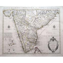
Carte des Côtes de Malabar et de Coromandel...
A fantastic map of southern India. Indicates the names of the European countries in power in several cities, for example "Cochin aux Hollandois"; "Pondiche...
Date: Amsterdam, c1745
Selling price: ????
Please login to see price!
Sold in 2016
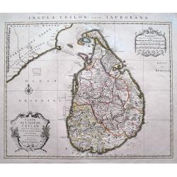
Carte de L'Isle de Ceylan Dressée sur les Observations...
A scarce large scale map of Sri Lanka (Ceylon). Highly detailed with many place names, rivers, hills, roads, and depth soundings shown.Embellished with two decorative car...
Date: Amsterdam, c 1745
Selling price: ????
Please login to see price!
Sold in 2016
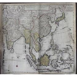
Carte des Indes et de la Chine Dressée. . .
A large, important, and very decorative map of South East Asia, India and China.The map is particularly interesting due to the appearance of the sea between Korea and Jap...
Date: Amsterdam, ca. 1745
Selling price: ????
Please login to see price!
Sold in 2020
Asia.
Rare, small map of Asia around 1700, unknown author. A proto-Australia is depicted.
Date: ca. 1745
Selling price: ????
Please login to see price!
Sold in 2019
A Map of Karazm, Great Bukharia and Turkestan. . .
A pleasant little map of central Asia by Thomas Kitchin for Astley's "A New General Collection of Voyages and Travels. "Covers from the Caspian Sea across to th...
Date: London, 1745
Selling price: ????
Please login to see price!
Sold in 2019
![Plan de la baye de Manille capitale des isles Philippines située en l'isle Luçon [with] Plan de Pulo Condor ou Isle Condor située à l'extrémité orientale du golfe de Siam [and] Veue de l'Isle Condor. . .](/uploads/cache/39244-250x250.jpg)
Plan de la baye de Manille capitale des isles Philippines située en l'isle Luçon [with] Plan de Pulo Condor ou Isle Condor située à l'extrémité orientale du golfe de Siam [and] Veue de l'Isle Condor. . .
A first edition of the important and large French Sea chart including a chart of Manila Bay, Philippines, accompanied by a chart and view of Côn Son Island, Vietnam by J...
Date: Paris, 1745
Selling price: ????
Please login to see price!
Sold in 2017
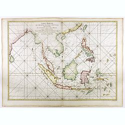
Carte réduite de l'archipel des Indes orientales avec les côtes du continent depuis le golfe de Manar jusqu'à Emoui à la Chine . . .
Important French chart of South East Asia with very good detail on Philippines. Latitude and longitude scales, compass rose and system of rhumb lines, soundings near coas...
Date: Paris, 1745
Selling price: ????
Please login to see price!
Sold in 2017
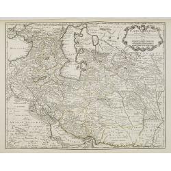
Carte de Perse.
A fine and detailed map of Iran, Iraq, and eastern Turkey. Published by P. Starckman and published by P.Buache in 1745.Guillaume de l'Isle (1675-1724), Royal Geographer, ...
Date: Paris, 1745
Selling price: ????
Please login to see price!
Sold in 2021
Nouvelle carte du Royaume de Bengale.
Rare map of Bangladesh with the Ganges delta, including Calcutta. Giving great detail with trade routes, European trade settlements, etc. Prepared by Joh. Van Leenen who ...
Date: Paris 1746
Selling price: ????
Please login to see price!
Sold in 2020
Carte des Isles du Japon et la Presqu'Isle de Coree..
A fine map of the islands of Japan embellished with fine baroque decorations.Bellin influenced other cartographers with his erroneous portrayals of Japan. Included in Ant...
Date: Paris 1746
Selling price: ????
Please login to see price!
Sold
Suite De L'Ocean Oriental.. Chine Les Isles Du Japon..
Fine map of South East Asia, New Guinee, coast of China, Korea and Japan. Several coastal towns noted, but little depicted in the interior.Japan is shown in Bellin's dist...
Date: Paris 1746
Selling price: ????
Please login to see price!
Sold
Das Kaiserthum China zur allgemeinen Historie der Reisen - entworfen von N. Bellin Ing. de la Mar. 1748.
Attractive and detailed map of China and Korea. The Sea of Japan is labeled "Das meer von Korea". The composition is nicely balanced with three decorative carto...
Date: Leipzig, Arkstee & Merkus, 1746
Selling price: ????
Please login to see price!
Sold in 2008
Fortsetzung der Karte von dem Morgenlaendischen Ocean die Eylande Sonda die Küsten von Tunquin und China die Eylande Japon.
Interesting and detailed map of Southeast Asia by Nicolas Bellin. Showing the Philippines, Indonesia, Japan, the east coast of China and parts of Papua New Guinea. With a...
Date: Leipzig, Arkstee & Merkus, 1746
Selling price: ????
Please login to see price!
Sold in 2009
Fortsetzung der Karte von dem Morgenlaendischen Ocean die Eylande Sonda die Küsten von Tunquin und China die Eylande Japon
Interesting and detailed sea chart of Southeast Asia by Nicolas Bellin. Showing the Philippines, Indonesia, Japan, the east coast of China and parts of Papua New Guinea. ...
Date: Leipzig, 1746
Selling price: ????
Please login to see price!
Sold in 2010
Das Kaiserthum China zur allgemeinen Historie der Reisen - entworfen von N. Bellin Ing. de la Mar. 1748.
Attractive and detailed map of China and Korea. The Sea of Japan is labeled "Das meer von Korea". The composition is nicely balanced with three decorative carto...
Date: Leipzig, Arkstee & Merkus, 1746
Selling price: ????
Please login to see price!
Sold
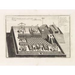
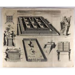
The observatory of Peking from Le Comte.
The observatory in Peking, in which there are very large instruments, an Equinoctial Sphere, a Celestial Globe, a Zodiacal Sphere, Azimuthal Horizona, Quadrant, and a Sex...
Date: London, 1746
Selling price: ????
Please login to see price!
Sold in 2014

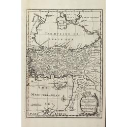
Imperium Ottomanno -Turcicum vel Turcarum posteriorum exhibens statum post pacem Passarovicensem.
Rare map of the Ottoman Empire, only known in one edition published in Haas's "Atlas historicus". This small but very detailed map extends from Spain and Morocc...
Date: Nuremberg, Homann, c1746
Selling price: ????
Please login to see price!
Sold in 2014
Mogol.
An attractive map of northern India with decorative cartouche, from 'Methode pour apprendre facilement la Geographie' by Jacques Robbe.small decorative title cartouche. W...
Date: Paris, 1746
Selling price: ????
Please login to see price!
Sold in 2017
A new & accurate map of Asia drawn from actual surveys. . .
An excellent early engraving of Asia. Curious shape for Japan, with a large island north called Yeso and a coastline marked De Gamma's Land. Numbered "No 52."; ...
Date: London, 1747
Selling price: ????
Please login to see price!
Sold in 2024
Carte des voyages de Notre seigneur Jesus Christ..
Showing eastern part of the Mediterranean, including Cyprus, Italy. Lower right hand corner inset plan of Jerusalem. Lower left map of Palestine. Published by Vaugondy, a...
Date: Paris, 1747
Selling price: ????
Please login to see price!
Sold in 2009
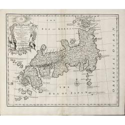
A New and Accurate Map of the Empire of Japan Laid down from the Memoirs of the Portuguese and Dutch and ... the Jesuit Missionaries
Bowen's map of Japan from 'A Complete System of Geography'. With an elaborate allegorical cartouche and a compass rose. The way in which the area to the north of Honshu i...
Date: London, 1747
Selling price: ????
Please login to see price!
Sold in 2011
A New & Accurate Map of China. Drawn from Surveys made by the Jesuit Missionaries, by Order of the Emperor
Bowen's map of China from 'A Complete System of Geography'. With an elaborate allegorical cartouche and a compass rose. Includes Korea and Formosa and advertising notes a...
Date: London, 1747
Selling price: ????
Please login to see price!
Sold in 2010
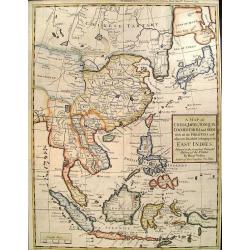
A New and Accurate Map of the East India Islands
Bowen's map of Southeast Asia from 'A Complete System of Geography'. With an elaborate allegorical cartouche and a compass rose. Includes the Philippines and part of Aust...
Date: London, 1747
Selling price: ????
Please login to see price!
Sold in 2010
Carte des voyages de Notre seigneur Jesus Christ. . .
Showing eastern part of the Mediterranean, including Cyprus, Italy. Lower right hand corner inset plan of Jerusalem. Lower left map of Palestine. Published by Vaugondy, a...
Date: Paris, 1747
Selling price: ????
Please login to see price!
Sold in 2011
An Accurate Map of Asia Minor, as Divided into its Provinces, before it became Possess'd by the Turks
Engraved map of Turkey by Bowen from 'A Complete System of Geography'. Showing Asia Minor with the Black-sea region and the eastern part of the Mediterranean sea with Cyp...
Date: London, 1747
Selling price: ????
Please login to see price!
Sold in 2013
![Kaartje Van TKeizer-Ryk China... [two maps]](/uploads/cache/92001-250x250.jpg)
Kaartje Van TKeizer-Ryk China... [two maps]
Two rare maps based on the work of De L'Isle, one of the Empire of China and a second of Chinese Tartary, including Korea and an oversized Hokkaido.
Date: Deventer, 1747
Selling price: ????
Please login to see price!
Sold in 2012
A Map of China, Japan, Tonquin, Cochin-China and Siam.
Uncommon map of South East Asia engraved by R.W. Seale.
Date: London, c. 1747
Selling price: ????
Please login to see price!
Sold in 2012
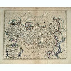
A New and Accurate Map of the Whole Russian Empire as contained both in Europe and Asia. . .
Detailed map of Russia, from the Sea of Anadyr, Sea of Kamchatka and the Kuril Islands to Poland. In the NW Coast of America references to Tschirikov's contact with Alask...
Date: London, c. 1747
Selling price: ????
Please login to see price!
Sold in 2013
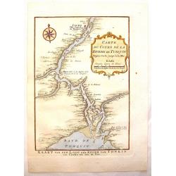
Carte du Cours de la Riviere de Tunquin.
Handsome hand colored map of the Tonkin River from Ho Chi Mingh to the Gulf of Tonkin. The map provides fine detail of the region and is embellished with a compass rose a...
Date: Paris, 1747
Selling price: ????
Please login to see price!
Sold in 2015
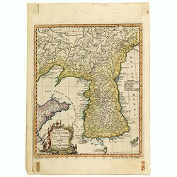
A map of Quan-Tonge province and the kingdom of Kau-Li or Korea.
Detailed map of Korea, Liaodong, and the tip of Shandong Province prepared by Thomas Kitchin for Thomas Salmon's "Universal Traveller", based on D'Anville's lan...
Date: London, 1747
Selling price: ????
Please login to see price!
Sold in 2023
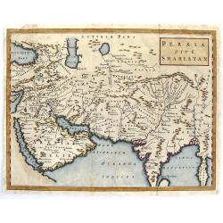
Persia Sive Shahistan.
Map of ancient western and southern Asia. The map is centered on Persia, but extends from Cyprus to east of the Ganges and as far north as the Caspian Sea. It uses the na...
Date: London, 1747
Selling price: ????
Please login to see price!
Sold in 2015
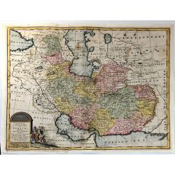
A New & accurate Map of Persia, with the Adjacent Countries.
A fine map of the Persian Empire including present day countries of Afghanistan, Iraq and Iran. Decorated with a pictorial title cartouche. Published in 1747 in Bowen’...
Date: Paris, 1747
Selling price: ????
Please login to see price!
Sold in 2015
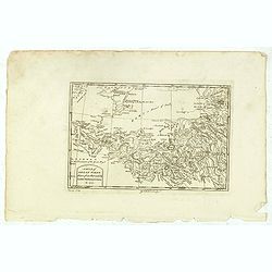
A Map of Great Tibet drawn from that made by Lama Mathematicians in 1717.
Uncommon map of the Gobi Desert, Kashgar regions with Tibet. Drawn from indigenous sources, including the Dalai Lama's mathematicians and engraved by G. Child - with his ...
Date: London, 1745-1747
Selling price: ????
Please login to see price!
Sold in 2015
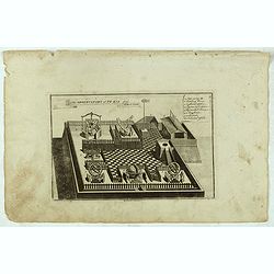
The observatory of Pe-kin from Le Comte.
Print of the observatory of Peking after Le Comte who visited the Peking Observatory in 1688. Engraved by G. Child - with his signature in lower bottom.From Astley, Thoma...
Date: London, 1745-1747
Selling price: ????
Please login to see price!
Sold in 2016