Browse Listings in Asia
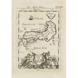
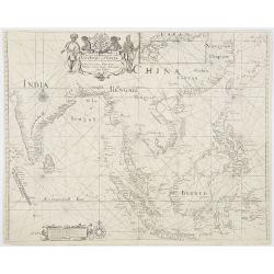
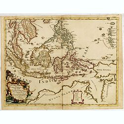
![Isole dell 'India cioè le Molucche le Filippine e della Sonda . . . [East Indies].](/uploads/cache/26611-250x250.jpg)
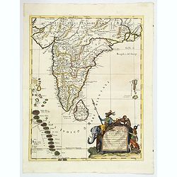
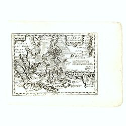
Isole dell 'India cioè le Molucche le Filippine e della Sonda . . . [East Indies].
In lower left hand corner a large title cartouche, decorated with mermaids, mermen and playful putti. A scarce, uncommon, late 17th century map of South East Asia, based ...
Date: Rome, 1683
Selling price: ????
Please login to see price!
Sold in 2008
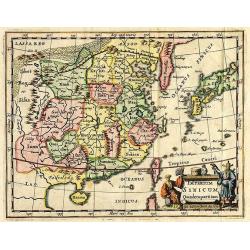
Imperium Sinicum Quindecupartitum.
This rare map is a reduced version of Kircher's map of China, printed in 1667. The cartouche features a Chinese hunter with a hawk and a seated Chinese lady holding a fan...
Date: 1683
Selling price: ????
Please login to see price!
Sold in 2012
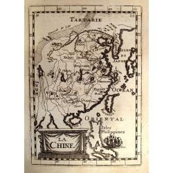
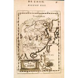
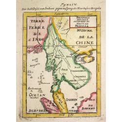
La Chine.
A charming small map of China, Taiwan, the Philippines, Korea, and Kyushu (Japan). From the original French text edition of "Description d'Univers..." b...
Date: Paris, 1683
Selling price: ????
Please login to see price!
Sold in 2009
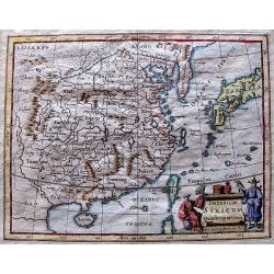
Imperium Sinicum Quindecupartitum.
This rare map is a reduced version of Kircher's map of China, printed in 1667. The cartouche features a Chinese hunter with a hawk and a seated Chinese lady holding a fan...
Date: 1683
Selling price: ????
Please login to see price!
Sold in 2012
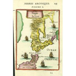
Terre de Iesso.
A charming small map of Hokkaido and the northern part of Honshu, by Allain Manneson Mallet (1630-1706), a well travelled military engineer and geographer who worked in 1...
Date: Paris, 1683
Selling price: ????
Please login to see price!
Sold in 2016
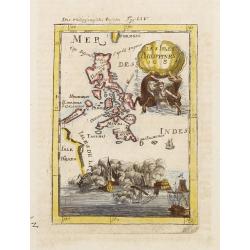
![Isole dell 'India cioè le Molucche le Filippine e della Sonda . . . [East Indies].](/uploads/cache/31192-250x250.jpg)
Isole dell 'India cioè le Molucche le Filippine e della Sonda . . . [East Indies].
In lower left hand corner a large title cartouche, decorated with mermaids, mermen and playful putti. A scarce, uncommon, late 17th century map of South East Asia, based ...
Date: Rome, 1683
Selling price: ????
Please login to see price!
Sold in 2011
La Chine.
A charming small map of China, Taiwan, the Philippines, Korea, and Kyushu (Japan). From the original French text edition of "Description d'Univers..." by Allain...
Date: Paris, 1683
Selling price: ????
Please login to see price!
Sold in 2012
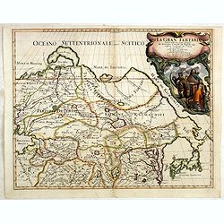
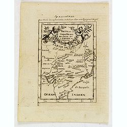
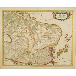
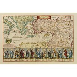
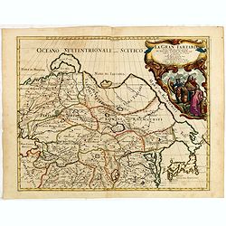
La Gran Tartaria divisa nelle sue parti pricipali da Giacomo
In upper right hand corner a large title cartouche with dedication to Tavernier and Thévenot. The cartographer was Giacomo Cantelli (1643-1695) who was active in Modena ...
Date: Rome, 1683
Selling price: ????
Please login to see price!
Sold in 2014
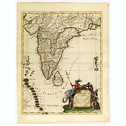
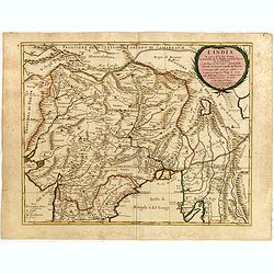
Penisola dell India di là dal Gange. . .
Giacomo Rossi's fine late 17th century map of India and Ceylon. Issued in Il Mercurio geografico In lower right hand corner a large title cartouche.The cartographer was G...
Date: Rome, 1683
Selling price: ????
Please login to see price!
Sold in 2015
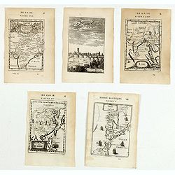
(Five engravings of Asian interest from Description de l\'Univers)
Finely etched prints and maps entitled : Terre de Iesso, La Chine, Inde, Visapor, Partie de la Terre Ferme de L'Inde ou L'Empire du Mogol. From the French text edition of...
Date: Paris, 1683
Selling price: ????
Please login to see price!
Sold in 2015
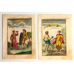
Habitans des Isles de la Sonde & Molusques (2 Prints)
Two fine engravings of the inhabitants of Indonesia. They are from "Geographie, Ancienne & Moderne."
Date: Paris, 1683
Selling price: ????
Please login to see price!
Sold in 2017
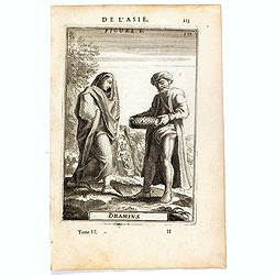
Bramins (de L'Asie / Figure L).
A fine and uncommon early 17th century miniature costume plate showing Brahmins from India.From the French text edition of Description d'Univers, 1683. by Allain Manneson...
Date: Paris, 1683
Selling price: ????
Please login to see price!
Sold in 2016
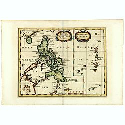
Insulae Philippinae (with inset of the Ladrones).
Fine example of this detailed map the Philippines, including a large inset map of the Ladrones. This is one of the earliest obtainable maps to focus on the Philippine isl...
Date: Utrecht/Amsterdam, J.Halma, 1683
Selling price: ????
Please login to see price!
Sold in 2019
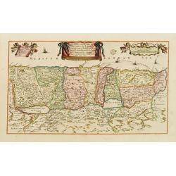
Penisola dell'India di qua dal Gange et Isole intorno ad essa adiacenti. DA GIACOMO CANTELLI DA VIGNOLA.
This is an uncommon map showing the southern part of India, with Sri Lanka and Maldives, from "Mercurio Geografico", published in Rome by G. de Rossi. A very ni...
Date: Italy, 1683
Selling price: ????
Please login to see price!
Sold in 2020
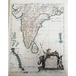
Penisola Dell India di qua dal Gange. . .
A lovely, decorative map of India, Ceylon (Sri Lanka) the Maldive Islands, and surrounds, by Cantelli da Vignola, and published by Rossi in Rome. Plenty of good map detai...
Date: Rome, 1683
Selling price: ????
Please login to see price!
Sold in 2020
Isles du Japon.
A charming late 17th century French map with a very decorative title cartouche showing trumpet-blowing cherubs.From the German text edition published by Davis Zunners. Je...
Date: Franckfurt 1684
Selling price: ????
Please login to see price!
Sold
Les Isles Philippines 1684.
A charming late 17th century French map of the Philippines with a large pictorial cartouche depicting a mermaid with sea horses, a nautical sailing ship scene across the ...
Date: Franckfurt 1684
Selling price: ????
Please login to see price!
Sold
Manille.
A charming late 17th century French bird's-eye view of Manila and its harbour. With a ribbon style title cartouche and a nautical sailing ship scene on the bottom.By Alla...
Date: Franckfurt 1684
Selling price: ????
Please login to see price!
Sold
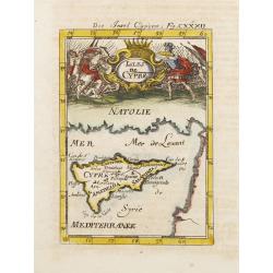
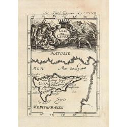
Isles de Cypre.
A charming late 17th century French map of Cyprus with a large pictorial cartouche depicting an infantry combat.By Allain Manneson Mallet (1630-1706), a well traveled mil...
Date: Franckfurt 1684
Selling price: ????
Please login to see price!
Sold
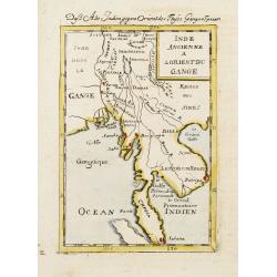
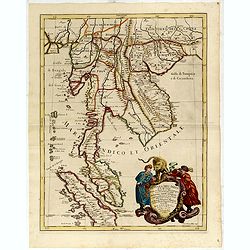
Inde Ancienne A L'Orient Du Gange.
A charming late 17th century French map of the area east of Ganges River, covering Myanmar, Thailand, Cambodia, Laos, Vietnam, part of Malaysia and Sumatra.By Allain Mann...
Date: Franckfurt 1684
Selling price: ????
Please login to see price!
Sold
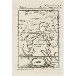
Inde.
A charming late 17th century French map of India, Malay Peninsular with a decorative title cartouche.By Allain Manneson Mallet (1630-1706), a well traveled military engin...
Date: Frankfurt, 1684
Selling price: ????
Please login to see price!
Sold in 2008
![Isle de la Sonde vers L\'Orient. [Moluccan Islands]](/uploads/cache/26298-250x250.jpg)
Isle de la Sonde vers L\'Orient. [Moluccan Islands]
A charming late 17th century map of the Moluccas Islands. By Allain Manneson Mallet (1630-1706), a well traveled military engineer and geographer who worked in 17th centu...
Date: Frankfurt, 1684
Selling price: ????
Please login to see price!
Sold in 2008
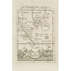
Isles de Maldives.
A charming late 17th century French map of the Maldives Islands.From the German text edition published by Davis Zunners. Allain Manneson Mallet (1630-1706), a well travel...
Date: Frankfurt, 1684
Selling price: ????
Please login to see price!
Sold in 2011
Isles du Japon. / Die Insel Japon.
A charming late 17th century French map of the islands of Japan with a very decorative title cartouche showing trumpet-blowing cherubs.From the German text edition publis...
Date: Frankfurt, 1684
Selling price: ????
Please login to see price!
Sold in 2008
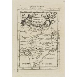
Partie de la Terre Ferme de l\'Inde ou l\'Empire du Mongol.
Map of India. From the German text edition published by Davis Zunners. Allain Manneson Mallet (1630-1706), a well traveled military engineer and geographer who worked in ...
Date: Frankfurt, 1684
Selling price: ????
Please login to see price!
Sold in 2011
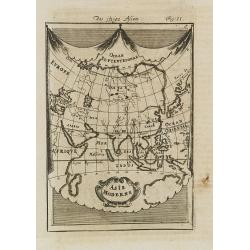
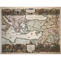
Asie Moderne.
A charming late 17th century French map of Asia.From the German text edition published by Davis Zunners. Allain Manneson Mallet (1630-1706), a well traveled military engi...
Date: Frankfurt, 1684
Selling price: ????
Please login to see price!
Sold in 2008
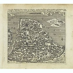
Constantinople.
Uncommon bird's-eye town-plan of Constantinople Published in "Der Donau-Strand mit allen seinen Ein- und Zuflüssen. . ." Published by Jacob Sandrart.
Date: Nuremberg, Jacob Sandrart, 1684
Selling price: ????
Please login to see price!
Sold in 2016
Partie de la Terre Ferme de l'Inde ou l'Empire du Mongol.
Map of India. From the German text edition published by Johann David Zunners of Frankfurt. Allain Manneson Mallet (1630-1706), a well traveled military engineer and geogr...
Date: Frankfurt, 1684
Selling price: ????
Please login to see price!
Sold in 2020
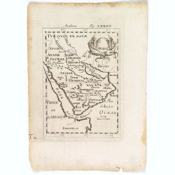
Arabie.
An attractive small map of the Arabian peninsular.
Date: Frankfurt, 1684
Selling price: ????
Please login to see price!
Sold in 2018
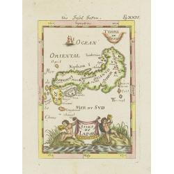
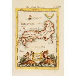
Isles du Japon.
A charming late 17th century French map with a very decorative title cartouche showing trumpet-blowing cherubs, by Allain Manneson Mallet (1630-1706), a well traveled mil...
Date: Paris, 1685
Selling price: ????
Please login to see price!
Sold in 2021
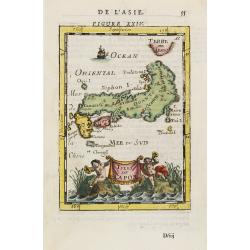
Isles du Japon.
A charming late 17th century French map with a very decorative title cartouche showing trumpet-blowing cherubs, by Allain Manneson Mallet (1630-1706), a well traveled mil...
Date: Paris, 1685
Selling price: ????
Please login to see price!
Sold in 2013
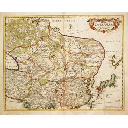
Tabula Tartariae et majoris partis Regni Chinae
Nice map of the region from the Caspian Sea through China and Japan. Eastern Russia is truncated with no Kamchatka peninsula and Yedso is shown according to the voyages o...
Date: Amsterdam 1685
Selling price: ????
Please login to see price!
Sold
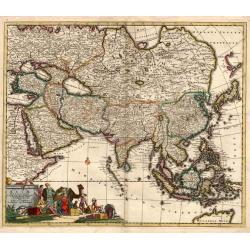
Exactissima Asiae delineatio
An attractive full color example of Danckerts scarce map of Asia and the Northern part of Australia based on De Wit. The map extends North to the unknown coasts of Yesso ...
Date: Amsterdam, 1685
Selling price: ????
Please login to see price!
Sold
Tabula Tartariae et majoris partis Regnis Chinae.
Frederick de Wit (1610-1698) became after the closing of the Blaeu firm one of the most important Amsterdam-based publishers. He published several atlases, Atlas Minor (1...
Date: Amsterdam, c. 1685
Selling price: ????
Please login to see price!
Sold in 2013
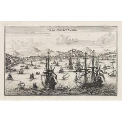
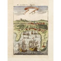
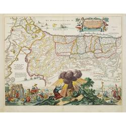
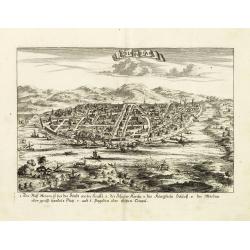
Die Statt Malacca in Indien.
Panoramic town-view of Malacca, published in Wagner, "Delineatio Provinciarum Pannoniae". Unsigned engraving. The engravings for Wagner's book were executed by ...
Date: Augsburg, Koppmayer, 1685
Selling price: ????
Please login to see price!
Sold in 2016
A chart of the trading part of the East Indies and China with the adjaccent islands of Surrat to Japan. . .
In upper part a fine title cartouche with the names of John Thornton, John Seller, William Fisher, James Atkinson and John Colton. With inset map (63x136mm) of Japan. Cov...
Date: London, 1685
Selling price: ????
Please login to see price!
Sold in 2010
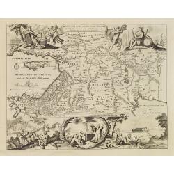
![[Lot of 6 maps of the eastern Mediterranean] Estats / du Grand Seigneur / des Turcs / en Europe, en Asie et en Afrique](/uploads/cache/18520-250x250.jpg)
[Lot of 6 maps of the eastern Mediterranean] Estats / du Grand Seigneur / des Turcs / en Europe, en Asie et en Afrique
An attractive large-format map showing the Turkish empire in Europe, Asia and Africa, comprising the eastern Mediterranean and the Near East. Embellished with a large t...
Date: Amsterdam, c. 1685
Selling price: ????
Please login to see price!
Sold in 2022
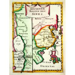
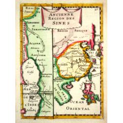
Ancienne Region des Sines.
Alain Manneson Mallet (1603-1706) published in 1683 his ' Description de l' Univers' in 5 volumes. In 1686 a German edition appeared.A map from Alain Manesson Mallet's 'D...
Date: Paris, 1686
Selling price: ????
Please login to see price!
Sold in 2017
Perigrinatie ofte Veertich-jarige Reyse der Kinderen Israels.
Dutch so-called "Staten" bibles, published between 1637 and c. 1760, contained 5 maps: The World, "Paradise", The Perigrinations, The Promised Land Ca...
Date: H. Keur en M. Doornik, Dordrecht-Amsterdam, 1686
Selling price: ????
Please login to see price!
Sold
Perigrinatie ofte Veertich-jarige Reyse der Kinderen Israels.
Holy Land (Israels Pergrination, or the Forty Years Travels of the Children of Israel out of Egypt through the Red Sea, and the Wilderness into Canaan, or The Land of Pro...
Date: Amsterdam / Dordrecht, H.,J., en M. Doornick 1682-1686
Selling price: ????
Please login to see price!
Sold in 2008
Ancienne Region des Sines.
Alain Manneson Mallet (1603-1706) published in 1683 his ' Description de l' Univers' in 5 volumes. In 1686 a German edition appeared.A map from Alain Manesson Mallet's 'D...
Date: Paris, 1686
Selling price: ????
Please login to see price!
Sold
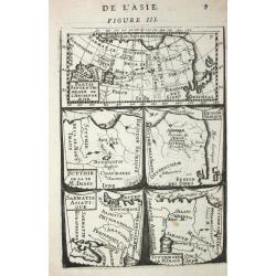
Partie septentrionale de l' Ancienne Asie /Scythie de la M. Imaus / Region Serique / Samatie Asiatique / Scythie deca le M.Imaus.
Alain Manneson Mallet (1603-1706) published in 1683 his ' Description de l' Univers' in 5 volumes. In 1686 a German edition appeared.5 little maps on one sheet
Date: Paris, 1686
Selling price: ????
Please login to see price!
Sold in 2008
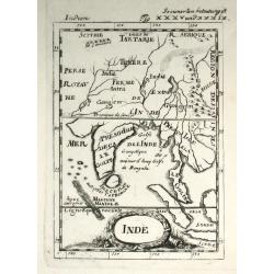
Inde
Alain Manneson Mallet (1603-1706) published in 1683 his ' Description de l' Univers' in 5 volumes. In 1686 a German edition appeared. A map from the German edition of 'De...
Date: Paris, 1686
Selling price: ????
Please login to see price!
Sold
Perigrinatie ofte Veertich-jarige Reyse der Kinderen Israels.
Dutch so-called ' Staten' bibles, published between 1637 and c. 1760, contained five maps: The World, ' Paradise', The Perigrinations, The Promised Land Canaan, The Trave...
Date: Amsterdam / Dordrecht, H.,J., en M. Doornick 1682-1686
Selling price: ????
Please login to see price!
Sold
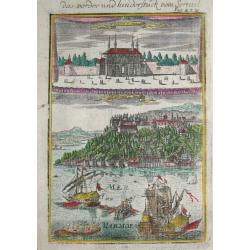
Das vorder und hinderstück vom Serrail.
Alain Manneson Mallet (1603-1706) published in 1683 his ' Description de l' Univers' in 5 volumes. In 1686 a German edition appeared.The serail in Istanbul seen from the ...
Date: Frankfurt, 1686
Selling price: ????
Please login to see price!
Sold
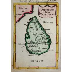
Ancienne Isle Taprobane.
Alain Manneson Mallet (1603-1706) published in 1683 his ' Description de l' Univers' in 5 volumes. In 1686 a German edition appeared.A map from Alain Manesson Mallet's 'D...
Date: Paris, 1686
Selling price: ????
Please login to see price!
Sold in 2017
Het Beloofde Landt Canaan door wandelt van onsen Salichmaecker Iesu Christo, neffens syne Apostelen.
Dutch so-called ' Staten' bibles, published between 1637 and c. 1760, contained five maps: The World, ' Paradise', The Perigrinations, The Promised Land Canaan, The Trave...
Date: Amsterdam / Dordrecht, H.,J., en M. Doornick 1682-1686
Selling price: ????
Please login to see price!
Sold
De Beschryving van de Reysen Pauli en Van de Andere Apostelen.
The Dutch so-called ' Staten' bibles published between 1637 and c. 1760, contained 5 maps: The World, ' Paradise', The Perigrinations, The Promised Land Canaan, The Trave...
Date: Dordrecht-Amsterdam, H. Keur en M. Doornik, 1686
Selling price: ????
Please login to see price!
Sold
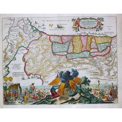
Odia in Siam
Rare panoramic town-view of Bangkok, published in J.C. Wagner "Interiora orientis detecta, oder grundrichtige und eigentl. Bescheibung aller . . . Reiche des Orients...
Date: Augsburg, Koppmayer,1686
Selling price: ????
Please login to see price!
Sold in 2011
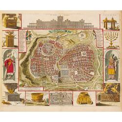
Jerusalem.
Dutch so-called '' Staten'' bibles, published between 1637 and c. 1760, contained 5 maps: The World, '' Paradise'', The Perigrinations, The Promised Land Canaan, The Trav...
Date: Amsterdam / Dordrecht, H. & J. Keur & M. Doornick, 1686
Selling price: ????
Please login to see price!
Sold in 2008
Presqu'isle de l 'lnde a l' Orient de Bengala.
Alain Manneson Mallet (1603-1706) published in 1683 his ' Description de l' Univers' in 5 volumes. In 1686 a German edition appeared.A map from Alain Manesson Mallet's 'D...
Date: Paris, 1686
Selling price: ????
Please login to see price!
Sold in 2008
De Beschryving van de Rysen Pauli..
First state of this richly decorative map of the eastern part of the Mediterranean. The map has vignettes at the top and bottom showing episodes from the book of Acts det...
Date: Amsterdam, 1686
Selling price: ????
Please login to see price!
Sold in 2009
Die Insel Cypern / Isles de Cypre
Decorative engraved map of Cyprus from Alain Manesson Mallet. With a interesting battle scene.
Date: Frankfurt, 1686
Selling price: ????
Please login to see price!
Sold in 2009
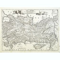
Asia minoris, . . .
Detailed map of Turkey with Cyprus, by Giacomo Cantelli da Vignola (1643-1695). Map Turkey's cities and political divisions as they existed during the Roman Empire.Engrav...
Date: Rome, 1686
Selling price: ????
Please login to see price!
Sold in 2011

Asiae Minoris lacobi cantelly vineolensis...
Giacomo Rossi's fine late 17th century map of Turkey and Cyprus. Issued in Il Mercurio geografico
Date: Rome, 1686
Selling price: ????
Please login to see price!
Sold in 2015
Asiae Minoris lacobi cantelly vineolensis...
Giacomo Rossi's fine late 17th century map of Turkey and Cyprus. Issued in Il Mercurio geografico In upper center a tittle cartouche.The cartographer was Giacomo Cantelli...
Date: Rome, 1686
Selling price: ????
Please login to see price!
Sold in 2016
Beschryvinge van den Oorsprong der Volkeren, Uit de drie..
A very decorative map of the region from the Mediterranean through to the Persian Gulf, including Cyprus.The map depicts the Garden of Eden, Abraham's route from Ur, and ...
Date: Amsterdam, 1687
Selling price: ????
Please login to see price!
Sold
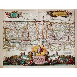
Canaan comonly called the Holy Land or the Land of Promise.
The engraver of this map was Richard Palmer.Rare and beautifully engraved map of the ancient land of Canaan which roughly corresponds to present-day Israel. Cherubs hold ...
Date: London, 1687
Selling price: ????
Please login to see price!
Sold in 2012
A mapp of the travels and voyages of the apostles..
The engraver of this map was Richard Palmer.Finely engraved detailed map covering the whole of the eastern Mediterranean. Showing the travels of the apostles after the de...
Date: London 1687
Selling price: ????
Please login to see price!
Sold
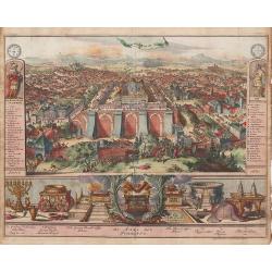
Jerusalem en syn Tempel.
An uncommon, panoramic view depicting the layout of the city surrounding the temple and filled with people, soldiers, livestock and a scene of Judas embracing Jesus and s...
Date: Amsterdam, 1687
Selling price: ????
Please login to see price!
Sold in 2013
Les Isles des Indes Orientalle.
Rare map of Indonesia, with an oversized Philippines, published by François Jollain (ca. 1641 – 18 April 1704) and included in "Trésor Des Cartes Geographiques D...
Date: Paris, 1687
Selling price: ????
Please login to see price!
Sold in 2018
Canaan Commonly Called The Holy Land or The Land of Promise. . .
A fine copperplate map of the Holy land along the Mediterranean Sea, based on the work of Visscher. The track of the Apostle Paul is shown in the Mediterranean Sea. With ...
Date: London, 1687
Selling price: ????
Please login to see price!
Sold in 2023
Perigrinatie ofte Veertigh-Iarige Reyse der Kinderen Israels, uyt Egypten door de Roode Zee, ende de Woestyne tot in 't Beloofde Landt Canaan.
Beautiful Dutch Bible map of the Holy Land divided into the twelve Tribes of Israel and depicting the Exodus from Egypt and the wanderings of the Children of Israel. The ...
Date: Amsterdam, 1687
Selling price: ????
Please login to see price!
Sold in 2020
Isole dell' India cioe la molucche Le Filippine...
Giacomo Rossi's fine late 17th century map of South East Asia, with nice detail on Philippines. Issued in Il Mercurio geografico In lower left corner a tittle cartouche. ...
Date: Rome, 1683-1688
Selling price: ????
Please login to see price!
Sold in 2017
De Gelegentheyt van t' Paradys en t' Landt Canaan, mitsgaders d' eerst bewoonde Landen der Patriarchen.
Dutch so-called ' Staten' bibles, published between 1637 and c. 1760, contained 5 maps: The World, ' Paradise', The Perigrinations, The Promised Land Canaan, The Travels ...
Date: Amsterdam, Hendrik Keur en Marcus Doornick, 1688
Selling price: ????
Please login to see price!
Sold in 2009
![[ Asia ]](/uploads/cache/30315-250x250.jpg)
[ Asia ]
Charming wood block map of Asia by the Italian XVIth and XVIIth century writer, humanist and cartographer Giuseppe Rosaccio. Taken from "Teatro del mondo e sue parti...
Date: Bologna, 1594 - 1688
Selling price: ????
Please login to see price!
Sold in 2014
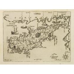
CIPRO
Rare map of the island of Cyprus from Francesco Piacenza's : L'Egeo Redivivo o'sia Chrorographia dell'Arcipelago, e dello stato primiero, & attuale di quell'isole, re...
Date: Modena, 1688
Selling price: ????
Please login to see price!
Sold
Penisola dell India di là dal Gange et Isole intorno ad essa adiacenti..
Giacomo Rossi's fine late 17th century map of India with Ceylon and Maldives. Issued in Il Mercurio geografico In lower right hand corner a large title cartouche with ded...
Date: Rome, 1683-1688
Selling price: ????
Please login to see price!
Sold
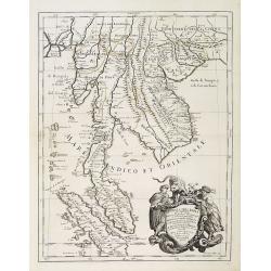
Penisola dell India di là dal Gange. . .
Giacomo Rossi's fine late 17th century map of Malaysia, Thailand, Cambodia and part of Sumatra. Issued in Il Mercurio geografico In lower right hand corner a large title ...
Date: Rome, 1683-1688
Selling price: ????
Please login to see price!
Sold in 2013
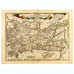
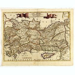
Natolia detta anticamente Asia minore...
Giacomo Rossi's fine late 17th century map of Ancient Turkey, with Cyprus. Issued in Il Mercurio geografico In upper center title cartouche.
Date: Rome, 1686-1688
Selling price: ????
Please login to see price!
Sold in 2015

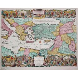
L'Asia...
Engraved by Giorgio Widman. Giacomo Rossi's fine late 17th century map of the Asian continent. Issued in Il Mercurio geografico In upper left corner a tittle cartouche. T...
Date: Rome, 1677-1688
Selling price: ????
Please login to see price!
Sold in 2015
La gran tartaria...
Giacomo Rossi's fine late 17th century map of Tartary. Issued in Il Mercurio geografico In upper right corner a tittle cartouche. The cartographer was Giacomo Cantelli da...
Date: Rome, 1683-1688
Selling price: ????
Please login to see price!
Sold in 2015
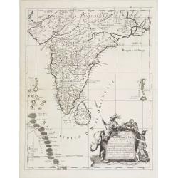
L'India. . .
Giacomo Rossi's fine late 17th century map of India. Issued in Il Mercurio geografico In upper right corner a tittle cartouche.
Date: Rome, 1683-1688
Selling price: ????
Please login to see price!
Sold in 2015

Isole dell' India cioe la molucche Le Filippine...
Giacomo Rossi's fine late 17th century map of South East Asia. Issued in Il Mercurio geografico In lower left corner a tittle cartouche. The cartographer was Giacomo Cant...
Date: Rome, 1683-1688
Selling price: ????
Please login to see price!
Sold in 2015
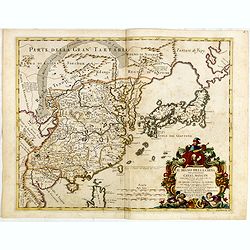
Il regno della China detto presentemente Catay Mangin...
Giacomo Rossi's fine late 17th century map of China, Korea, Taiwan and Japan. Issued in Il Mercurio geografico In lower left corner a tittle cartouche. The cartographer w...
Date: Rome, 1682-1688
Selling price: ????
Please login to see price!
Sold in 2015
Penisola della India...
Giacomo Rossi's fine late 17th century map of southeast Asia, extending from the border of China in the north ("frontiere della China"), with the entire Malaysi...
Date: Rome, 1683-1688
Selling price: ????
Please login to see price!
Sold in 2015
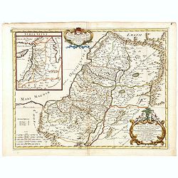
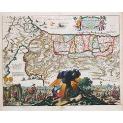
Terra Sancta siue Promissionis, olim Palestina, in duo divisa Regna, Israel, et luda, et in sex subdivisa Provincias scilicet Iudae, Samaria, Galilea, Trachonitide, Peraea. . .
Rossi's map of Holy Land, based upon Sanson's map, but with revised Italian nomenclature. The Holy Land divided between the kingdoms of Judea and Israel. Divided into six...
Date: Rome, 1677-1688
Selling price: ????
Please login to see price!
Sold in 2015
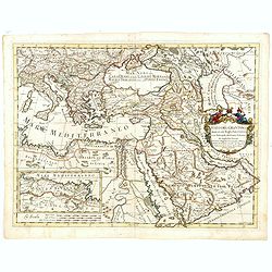
Stato del Gran Turco diviso ne suoi Beglierbati, . . .
Rossi's scarce map of Turkish Empire with the Eastern Mediterranean, Cyprus, Turkey, Arabia, the Black Sea, Asia Minor and neighboring regions.
Date: Rome, 1679-1688
Selling price: ????
Please login to see price!
Sold in 2015
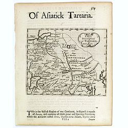
A New Description of Tartarie.
A pleasing small map of Tartary (northeastern Russia and China) showing mountains, Caspian Sea, Lakes and rivers, and The Great Wall of China, towns and cities.This lovel...
Date: London, c 1688
Selling price: ????
Please login to see price!
Sold in 2017
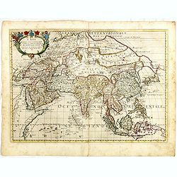
L'Asia Nuovamente corretta et accresciuta, secondo le relationi piu moderne da Guglielmo Sansone . . . 1677
Giacomo Rossi's fine late 17th century map of the Asian continent. Nice detail of the Philippines, China and Arabia. The area north of Japan called Yuppi and attached to ...
Date: Rome, 1677-1688
Selling price: ????
Please login to see price!
Sold in 2017
