Browse Listings in America
![View of the natural bridge. [title in French, English, German & Latin] N°53. Pl. 5.](/uploads/cache/26819-250x250.jpg)
View of the natural bridge. [title in French, English, German & Latin] N°53. Pl. 5.
A view of a natural bridge.From 13e Livraison Amérique Septentrionale - Etat de New York. After Jacques Milbert and lithographed by Bichebois and figures by V. Adam. Pri...
Date: Paris, Bove dirigée par Nöel ainé & Cie, 1892
Selling price: ????
Please login to see price!
Sold in 2009
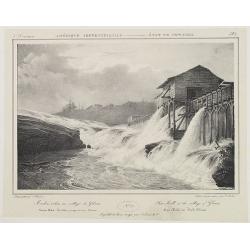
Saw-Mill at the village of Glenns. . . N°23. Pl.3.
A view of the saw mill at the village of Gleens.From 6e Livraison Amérique Septentrionale - Etat de New York. After Jacques Milbert and lithographed by Villeneuve. Print...
Date: Paris, Bove dirigée par Nöel ainé & Cie, 1892
Selling price: ????
Please login to see price!
Sold in 2010
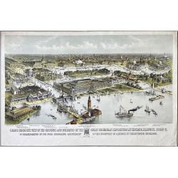
Grand Birds-Eye View of the Grounds and Buildings of the Great Columbian Exposition at Chicago, Illinois, 1892-3.
Lithography after a watercolor by C. Graham created as part of a portfolio for the World's Columbian Exposition (also known as the Chicago World's Fair) was a world's fai...
Date: New York, 1892
Selling price: ????
Please login to see price!
Sold in 2023
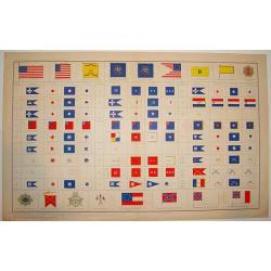
ATLAS TO ACCOMPANY THE OFFICIAL RECORDS OF THE UNION AND CONFEDERATE ARMIES, 1861-1865
An impressive and rarely seen double-page lithographic print of official U.S. Civil War-era national and military standards, badges, and icons. More than 100 items are de...
Date: New York, ca. 1894
Selling price: ????
Please login to see price!
Sold
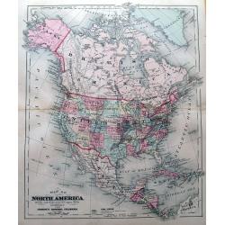
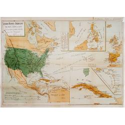
Map of North America.
Attractive map of North America during the late 19th century. With the Indian Territory north of Texas. Indicates coal fields, and shows railways.
Date: New York, 1894
Selling price: ????
Please login to see price!
Sold in 2015
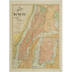
Map of New York City showing portions of Brooklyn, Jersey City, and Westchester Co.
Map of the routes of the train system around New York. With inset plan of lower Manhattan. On verso Guide map of New York City, with lovely illustration of Broadway Centr...
Date: Chicago & New York, 1895
Selling price: ????
Please login to see price!
Sold
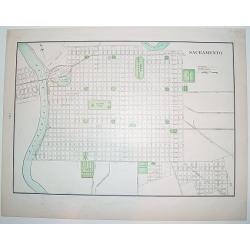
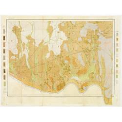
Sacramento.
A nice, late 19th century plan of the City of Sacramento, capital of California. The map shows the city's existing railway as well as the "proposed railway". On...
Date: New York, ca. 1895
Selling price: ????
Please login to see price!
Sold
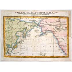
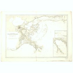
Carte de la Partie Septentrionale de la Mer du Sud, Comprise entre La Californie, Les Isles Sandwich, Le Japon et le Detroit de Behring
An informative Cook's map of the Pacific Ocean with the Behring Straight and Hawaii featured. It shows the route of Captain Cook's 3rd voyage between 1778 and 1789. Lieut...
Date: Paris, ca. 1895
Selling price: ????
Please login to see price!
Sold in 2018
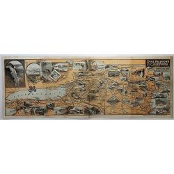
Bird's Eye View of the Tourists' Ideal Route from Niagara to the Sea.
A terrific "bird's eye view" of the Tourists' Ideal Route from Niagara to the Sea - ca. 1895. The maker is unknown, map shows from Nova Scotia to St Louis, and ...
Date: Buffalo, ca. 1895
Selling price: ????
Please login to see price!
Sold in 2018
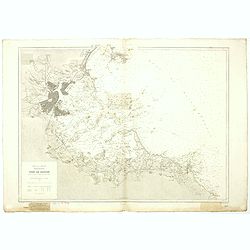
Port de Boston d'après la carte de l'United Coast Survey.
A fine French Service Hydrograhique de la Marine chart no. 4821, showing Boston Harbour, after maps of the United Coast Survey. A past-on (7 x 10 cm) has been pasted on t...
Date: Paris, 1895
Selling price: ????
Please login to see price!
Sold in 2019
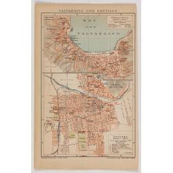
Valparaiso und Santiago.
Eye-bird view of Valparaiso bay, together with a city plan of Santiago. The print has been printed by F.A.Brockhaus Geogr. - artist. Anstalt, Germany in 1895.
Date: Germany, 1895
Selling price: ????
Please login to see price!
Sold in 2020
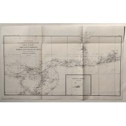
Sketch Showing Progress of Surveys on the Gulf Coast Lake Pontchartrain, Mobile and Pensacola Bays.
This is the Survey Report of 1896 by the U.S. Coast and Geodetic Department. It includes an insert of Tortugas Harbor.
Date: Washington, 1896
Selling price: ????
Please login to see price!
Sold in 2020
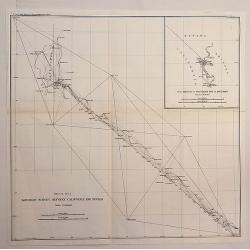
Boundary Survey Between California and Nevada.
An antique lithographic map published in 1896, Washington for "U.S. Coast and Geodetic Survey" . Includes an insert “SUB SKETCH OF SOUTHERN END OF BOUNDARY�...
Date: Washington, 1896
Selling price: ????
Please login to see price!
Sold in 2020
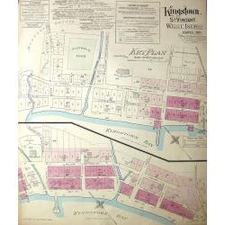
Kingston, St. Vincent. West Indies.
Large, uncommon fire insurance plan is presented on a scale of 120 feet to one inch. Lists the town with a population of 6000, from which 1/12 is white. Explains the main...
Date: Montreal/Toronto, 1897
Selling price: ????
Please login to see price!
Sold in 2014
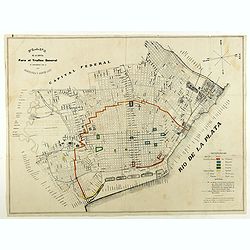
Plano de la capital para el trafico general de conformidad con la ordenanza 3 Agosto 1897.
City plan of Buenos Ayres in August 1897. With a color key in lower right corner.
Date: Italy, 1897
Selling price: ????
Please login to see price!
Sold in 2018
Guerre Hispano-Américaine.. Carte de Cuba, des petites Antilles et des Iles Philippines.
Interesting map of North and Central America. In upper right corner: 2e édition Revue et Completée. Text on verso relating to the history of Cuba Histoire de Cuba depui...
Date: Gent , 1898
Selling price: ????
Please login to see price!
Sold
Sound et delta du Mississippi / de la baie de Mobile à la Nouvelle Orléans d'après les Cartes de l'United Coast Survey...
A fine French Service Hydrograhique de la Marine chart no.4710, showing the Mississippi Delta from Mobile Bay to New Orleans, after maps of the United Coast Survey. With ...
Date: Paris, 1894 / 1898
Selling price: ????
Please login to see price!
Sold in 2019
Group of 5 maps and prints of North American interest.
Group of five prints and maps. - Map of the West Indies by W.Darton.- View of New York from Weehawken by W.H.Bartlett (120x180mm.)- Principal front of the capitol Washing...
Date: c. 1850-1900
Selling price: ????
Please login to see price!
Sold in 2014
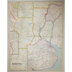
Central Argentina.
A large scale map of Argentina by George Philip & Son The map shows provincial boundaries, and is very high in contemporary detail.Published in London for The London ...
Date: London, 1900
Selling price: ????
Please login to see price!
Sold in 2016
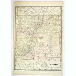
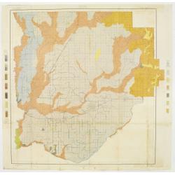
New Mexico.
A large, detailed map of New Mexico, possibly published at the turn of the last century. Each county is color coded, parcels of land and property are recorded, together w...
Date: Unknown, ca 1900
Selling price: ????
Please login to see price!
Sold in 2019
Nieuw Amsterdam op t Eylant Manhattans.
The rare and earliest obtainable view of Manhattan of ca. 1650 by J. Blaeu. The view is based on a prototype drawing, dated by J.M. de Koning to the year 1648, discovered...
Date: Amsterdam, 1652 but likely ca. 1900
Selling price: ????
Please login to see price!
Sold in 2020
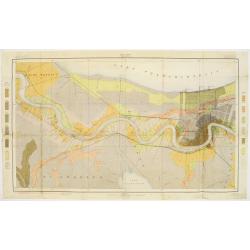
Delaware River from Cohansey to Philadelphia. From the United States Coast Survey, 1882. Inner sheet 2.
A fine Hydrographic Office chart no. 2564 figuring the Delaware River from Cohansey to Philadelphia based on a United States Coast Survey from 1882. Inner sheet 2. Engrav...
Date: London, 1882 / 1900
Selling price: ????
Please login to see price!
Sold in 2019
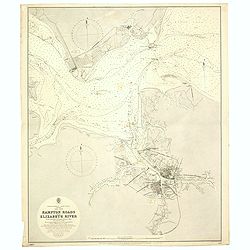
Hampton road and Elizabeth River. . .
A fine Hydrographic Office chart no. 2818, figuring Hampton Road, the James and Elizabeth Rivers and the cities of Norfolk and Portsmouth. Engraved by J. and C. Walker. L...
Date: London, 1892 / 1900
Selling price: ????
Please login to see price!
Sold in 2020
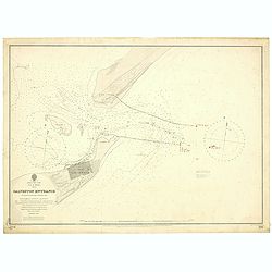
East Coast, Gulf of Mexico, Texas - Galveston Entrance from the latest United States Government Chart.
A fine Hydrographic Office chart no. 192 (1714) showing Galveston entrance. Engraved by Davies & Company. London : Published at the Admiralty, 6th Nov.r 1897 under th...
Date: London, 1897/ 1900
Selling price: ????
Please login to see price!
Sold in 2019
![[Detailed folding map of Nickerie River, Nickerie, Coronie in Suriname]](/uploads/cache/47218-250x250.jpg)
[Detailed folding map of Nickerie River, Nickerie, Coronie in Suriname]
Detailed folding map of Nickerie River, Nickerie, Coronie in Suriname. The Nickerie is a river in the northwestern part of Suriname. The river originates in the Bakhuis M...
Date: Surinam, or Netherlands, ca. 1900
Selling price: ????
Please login to see price!
Sold in 2022
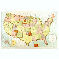
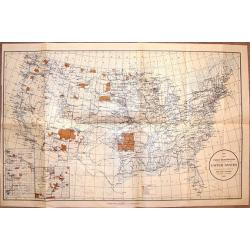
Map Showing Indian Reservations Within The Limits of the United States Compiled Under The Direction of the Hon. T. J. Morgan Commissioner of Indian Affairs 1901.
Fine example of the Indian Affairs Commissioner's Map of the United States. The present map locates all the lands reserved to Native American Tribes as of 1901.Inset maps...
Date: Washington D.C, 1901
Selling price: ????
Please login to see price!
Sold in 2017
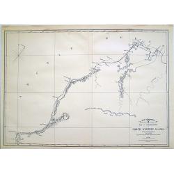
War Department Map of Exploration of North Western Alaska...
Unusual survey map of the Arctic Ocean and Northwestern Alaska.
Date: 1902
Selling price: ????
Please login to see price!
Sold in 2010
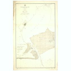
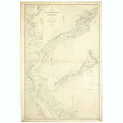
Sabine Pass and Lake / Louisiana and Texas (Polyconic proJection) / Scale 1/40 000.
A fine Hydrographic Office chart no. 517 showing Sabine Pass and Lake with Port Arthur in Louisiana and Texas.Published at Washington D.C. April, 1901, by the U. S. Coast...
Date: Washington D.C, 1901-1902
Selling price: ????
Please login to see price!
Sold in 2019
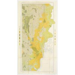
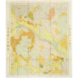
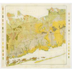
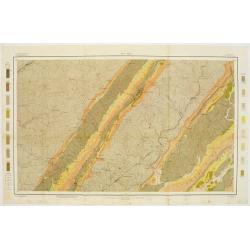
Soil map - Alabama, Mobile sheet.
Early color lithographed soil map by Julius Bien & Co. in New York for the Department of Agriculture. Legends at the side give details on soil type, etc. They also in...
Date: New York, 1903
Selling price: ????
Please login to see price!
Sold in 2017
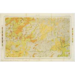
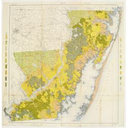
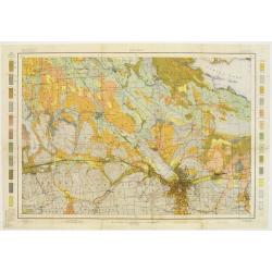
Soil map - North Carolina, Asheville sheet.
Soil map printed by Julius Bien & Co in New York for Department of Agriculture. The map is giving great detail of the area including and west of Asheville, North Caro...
Date: New York, 1903
Selling price: ????
Please login to see price!
Sold in 2017
Soil map - North Carolina, Craven sheet
Early color lithographed soil map by Julius Bien & Co. in New York for Department of Agriculture. Legends at side give detail on soil type, etc. They also include int...
Date: New York, 1903
Selling price: ????
Please login to see price!
Sold
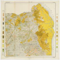
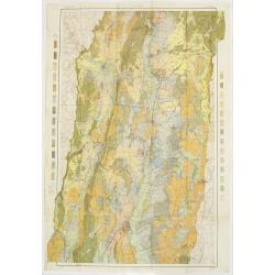
Soil map - Maryland, Worcester County sheet
Early color lithographed soil map by Julius Bien & Co. in New York for Department of Agriculture. Legends at side give detail on soil type, etc. They also include int...
Date: New York, 1903
Selling price: ????
Please login to see price!
Sold in 2009
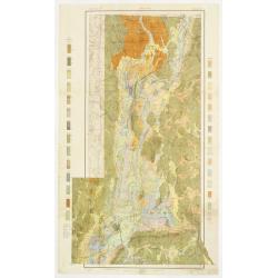
Soil map - Delaware, Dover sheet.
Early color lithographed soil map by Julius Bien & Co. in New York for Department of Agriculture. Legends at side give detail on soil type, etc. They also include int...
Date: New York, 1903
Selling price: ????
Please login to see price!
Sold in 2018
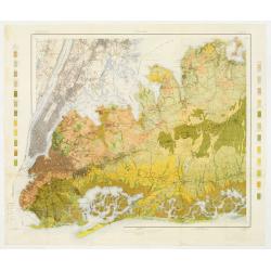
Soil map - New York, Hempstead sheet
Early color lithographed geological or soil map by Julius Bien & Co. in New York for the Department of Agriculture. Legends at the side give details on soil type, etc...
Date: New York 1903
Selling price: ????
Please login to see price!
Sold
Soil map - New York, Babylon sheet.
Early color lithographed soil map by Julius Bien & Co. in New York for Department of Agriculture. Legends at side give detail on soil type, etc. They also include int...
Date: New York, 1903
Selling price: ????
Please login to see price!
Sold in 2011
Soil map - New York, Syracuse sheet
Early color lithographed geological or soil map by Julius Bien & Co. in New York for the Department of Agriculture. Legends at the side give details on soil type, etc...
Date: New York 1903
Selling price: ????
Please login to see price!
Sold
Soil map - Connecticut. - Massachusetts, (Hartford) Springfield sheet.
Early color lithographed soil map by Julius Bien & Co. in New York for Department of Agriculture. Legends at side give detail on soil type, etc. They also include int...
Date: New York, 1903
Selling price: ????
Please login to see price!
Sold in 2008
Soil map - Massachusetts, Amherst sheet
Early color lithographed soil map by Julius Bien & Co. in New York for Department of Agriculture. Legends at side give detail on soil type, etc. They also include int...
Date: New York, 1903
Selling price: ????
Please login to see price!
Sold in 2009
Soil map - Alabama, Fort Payne sheet.
Early color lithographed geological or soil map by Julius Bien & Co. in New York for the Department of Agriculture. Legends at the side give details on soil type, etc...
Date: New York, 1903
Selling price: ????
Please login to see price!
Sold in 2011
Soil map - Alabama, Huntsville sheet
Early color lithographed soil map by Julius Bien & Co. in New York for the Department of Agriculture. Legends at the side give details on soil type, etc. They also in...
Date: New York 1903
Selling price: ????
Please login to see price!
Sold
Louisiana, New Orleans sheet.
soil map printed by Julius Bien & Co in New York for Department of Agriculture. The map is giving great detail of the area in the east of New Orleans, Louisiana, in t...
Date: New York, 1903
Selling price: ????
Please login to see price!
Sold in 2013
Soil map - Louisiana, Acadia Parish sheet.
Early color lithographed soil map by Julius Bien & Co. in New York for Department of Agriculture. Legends at side give detail on soil type, etc. They also include int...
Date: New York, 1903
Selling price: ????
Please login to see price!
Sold in 2009
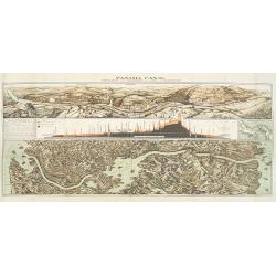
Panama Canal, Topographic, Diagramatic, and Illustrative.
Drawn in 1903, this "Topographic, Diagramatic, and Illustrative Map of the Panama Canal" illustrates the project for U.S. readers. The top panel depicts the exc...
Date: Washington, D. C., 1903
Selling price: ????
Please login to see price!
Sold in 2009
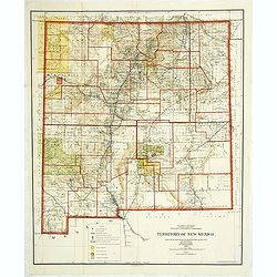
Department of the interior . . . Territory of New Mexico Compiled from the official Records. . .
Photolithography by Andrew B. Graham Washington, DC. Revised and drawn by Charles J. Helm.Detailed sepia tone topographic plat map with Indian Reservations in yellow, for...
Date: Washington, 1903
Selling price: ????
Please login to see price!
Sold in 2014
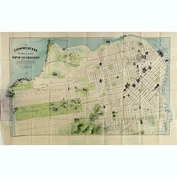
The commercial, pictorial and tourist map of San Francisco, in colors and illustrated with litho-engraved pictures of all public buildings, parks, monuments, and recommended business houses, etc. . . .
Important and rare pre-earth-quake San Francisco town plan. Covering from the "Sunset District" and the Blue Mountain, up to the Golden Gate and the northern sh...
Date: San Francisco, 1904
Selling price: ????
Please login to see price!
Sold in 2015
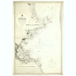
Boston Bay approaches from the latest United States Government Charts.
A fine Hydrographic Office chart no. 1227 figuring Boston Bay approaches from the latest United States Government Charts. Engraved by Davies and Company. London : Publish...
Date: London, 1904
Selling price: ????
Please login to see price!
Sold in 2020
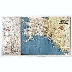
Map of Alaska, YukonTerritory and British Columbia showing connections of The White Pass & Yukon Route.
Railway map of Alaska, YukonTerritory and British Columbia showing connections of The White Pass & Yukon Route. On the back informations about the trip.
Date: Chicago, 1904
Selling price: ????
Please login to see price!
Sold in 2021
![[Official US Government Document.]](/uploads/cache/48155-250x250.jpg)
[Official US Government Document.]
An official US government printed document, completed in manuscript and signed by President Theodore Roosevelt, appointing John G. Chandler Brigadier-General on the retir...
Date: Washington D.C., 1904
Selling price: ????
Please login to see price!
Sold in 2022
![[North America]](/uploads/cache/25596-250x250.jpg)
[North America]
A more than 100 year old Russian map of North America printed in lithography. Published by one of the most successful publishers of St. Petersburg A.Iljin. With a color k...
Date: St. Petersburg, c.1905
Selling price: ????
Please login to see price!
Sold in 2013
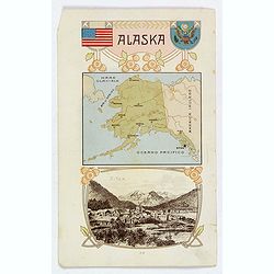
Alaska / Costume del S. Salvador.
An unusual item. It is a nice colored chromolithograph map of Alaska, with a few place names, a coat of arms and the American flag, together with a small view of Sitca be...
Date: Milano, 1905
Selling price: ????
Please login to see price!
Sold in 2019
Mensura de las minas.
Pen and ink drawing of mines in South America by Belisaeio Vergara and other sources of the mines "Porvenir", "Defensa" and "Amparo" in Chil...
Date: Chile, 1906
Selling price: ????
Please login to see price!
Sold in 2014
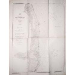
Barneget Inlet to Absecon Inlet. New Yersey . Coast Chart No. 122.
A sea chart of part of the coast of New Yersey with Atlantic City and the mouth of the Mullica river with Great Bay.
Date: Washington, 1906
Selling price: ????
Please login to see price!
Sold in 2018
sea chart of part of the coast of New Yersey. From Sandy hook to Barneget Inlet. New Yersey . Coast Chart No. 121.
A sea chart of part of the coast of New Yersey.
Date: Washington, 1906
Selling price: ????
Please login to see price!
Sold in 2020
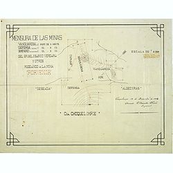
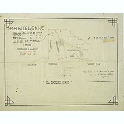
Mensura de las minas. . . Choquelimpie. (manuscript map)
Pen and ink drawing of the mines "Porvenir", "Defensa" and "Amparo" in Choquelimpe region in Chili by Belisaeio Vergara and E.Basadre Forero...
Date: Chile, Choquelimpie, 19 December 1906
Selling price: ????
Please login to see price!
Sold in 2015
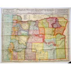
Oregon and Western Colonization Company map of Oregon.
Very detailed Oregon And Western Colonization Company real estate map in color. The Willamette Valley and Cascade Mountain Wagon Road Company sold their 800,000 land gran...
Date: Chicago, ca. 1909
Selling price: ????
Please login to see price!
Sold in 2013
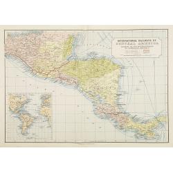
International Railways of Central America (chemins de fer internationaux de l'Amérique centrale).
Two colorful maps, a large one showing the railway systems in Central America by "International Railways of Central America" with a key to the ones unde...
Date: London, ca. 1910
Selling price: ????
Please login to see price!
Sold in 2009
Map Showing Indian Resevations Within the Limits of the United States.
Fine, large chromolithograph map showing American Indian Reservations after the turn of the century. It was compiled under the direction of the Honorable R.G. Valentine, ...
Date: Wahington, 1910
Selling price: ????
Please login to see price!
Sold in 2016
![[Official US Government Document.]](/uploads/cache/48154-250x250.jpg)
[Official US Government Document.]
An official US government printed document, completed in manuscript. An attractive engraved broadside, completed in manuscript and signed by President William Howard Taft...
Date: Washington D.C., 1910
Selling price: ????
Please login to see price!
Sold in 2022
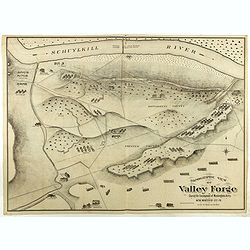
Topographic view of Valley Forge. During the Encompment of Washington's Army in the winter of 1777-78.
Fine and rare topographical view of Valley Forge, showing the area at the time of Washington's Encampment in December 1777 and January 1778. A reduced sized copy of the o...
Date: Philadelphia, 1911
Selling price: ????
Please login to see price!
Sold in 2020
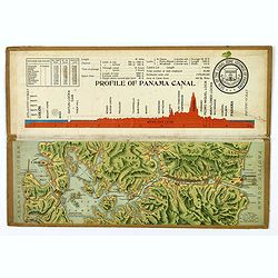
Souvenir Model of the Panama Canal.
A beautiful small profile map, on folding cardboard of the Panama Canal, by Maduro. The map is in raised profile, fully colored, and mounted on to original cardboard. The...
Date: Panama, 1911
Selling price: ????
Please login to see price!
Sold in 2019
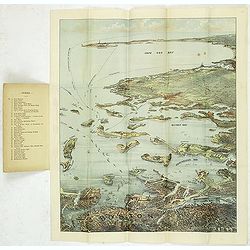
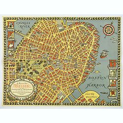
Bird's eye view of Boston Harbor and South Shore to Provincetown showing steamboat routes. Price 10 cents.
Lithographic bird's eye town-view view of Boston harbour, Massachusetts and the surrounding region (including Cape Cod). With a numbered key (1-35) on inside of the cover...
Date: Boston, Union News Company, South Station, ca. 1912
Selling price: ????
Please login to see price!
Sold in 2011
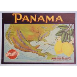
Panama.
A color printed vintage Panama Brand Lemon Crate Label, California Red Ball, Packed by Johnston Fruit Company, Santa Barbara, California.
Date: Sacramento, 1912
Selling price: ????
Please login to see price!
Sold in 2019
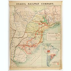
Brazil Railway Company.
Map of Brazil railway structure, from Rio de Janeiro to Rio de la Plata. Including a map of general South America. The map also shows part of Paraguay and Argentina.
Date: London, 1912
Selling price: ????
Please login to see price!
Sold in 2020
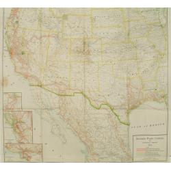
Southern Pacific Company and proprietary companies.
Map of the routes of the Southern Pacific Railway throughout California with connections to other parts of the United States. With inset maps of Los Angeles, San Francisc...
Date: Chicago & New York, 1915
Selling price: ????
Please login to see price!
Sold
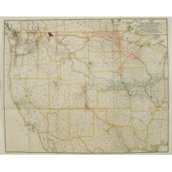
Map showing Great Northern Railway System..
Map of the rail way routes of the railway systems throughout the northern parts of the United States.
Date: Chicago & New York, 1915
Selling price: ????
Please login to see price!
Sold
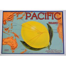
Pacific.
A color printed vintage 1917 Pacific Brand Lemon Crate Label, Packed by Johnston Fruit Company, Santa Barbara, California. This is an original crate label, not a copy.
Date: Santa Barbara, 1917
Selling price: ????
Please login to see price!
Sold in 2019
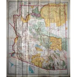
State of Arizona compiled chiefly from the official records of the General Land Office with supplemental data from other map making agencies, under the direction of I.P. Berthrong, chief of drafting division, G.L.O.
The map was compiled by Daniel P.O'Hare under the supervision of I. P. Berthrong, Drafting Division Chief of the General Land Office. It was printed by the Columbia Plano...
Date: Washington D.C., 1921
Selling price: ????
Please login to see price!
Sold in 2015
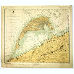
Erie Harbor and Presque Isle, Pennsylvania.
A US nautical chart of Erie Harbour and Presque Island in Pennsylvania - an eight updated edition (1924) to an original survey first undertaken in 1901 of the northern an...
Date: United States, 1924
Selling price: ????
Please login to see price!
Sold in 2021
![[ATLAS] Maps of the Bahama Islands with statics and index.](/uploads/cache/37319-250x250.jpg)
[ATLAS] Maps of the Bahama Islands with statics and index.
A rare atlas of the Bahama Islands published by the official authorities. Illustrated with 20 maps, followed 6 pages index. In the introduction the number of 53,000 inhab...
Date: London, Stanford's geog. Establ., 1926
Selling price: ????
Please login to see price!
Sold in 2019
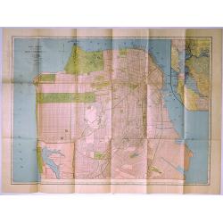
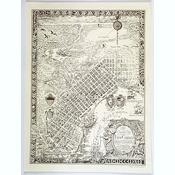
Rand McNally Standard Map of San Francisco.
A pleasing map of the city of San Francisco, California, issued by the Rand McNally and Company in 1927. It covers the entire city from Fort Point and Presidio Park as fa...
Date: Chicago, 1927
Selling price: ????
Please login to see price!
Sold in 2019
Pictorial map of New York City. . .
A lovely town plan of New York City, published by Arthur Crosby services, in 1928, on behalf of the Chase National Bank, which is very interesting, as the published date ...
Date: New York, 1928
Selling price: ????
Please login to see price!
Sold in 2018
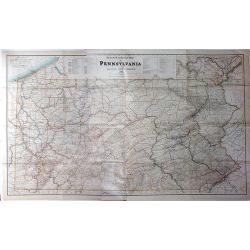
Steam Railroad Map of Pennsylvania.
A huge map, Issued by the Public Service Commission in 1929, by J. W. Clement Co., Matthews-Northrup Works, Buffalo, N. Y. This large folding map is the late twenties ver...
Date: Buffalo, 1929
Selling price: ????
Please login to see price!
Sold in 2017
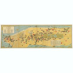
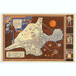
A Map of Old Boston in the Commonwealth of Massachusetts.
A quaint and charming pictorial map of the tourist sites of downtown Boston as seen in 1929. Buildings and streets are clearly marked. This map was drawn by Charles R. Ca...
Date: Boston, 1929
Selling price: ????
Please login to see price!
Sold in 2020
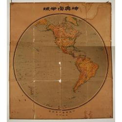
Chinese folding wall map of America.
Uncommon wall map of America, all in Chinese characters. In lower bottom Chinese manuscript characters.
Date: China c. 1930
Selling price: ????
Please login to see price!
Sold
Friendly Service Map of the Commonwealth of Ohio.
A scarce map of the Commonwealth of Ohio, published by the Mobile Oil Company between the wars. A fun and informative map with numerous topical small illustrations, place...
Date: Ohio, ca 1930
Selling price: ????
Please login to see price!
Sold in 2019
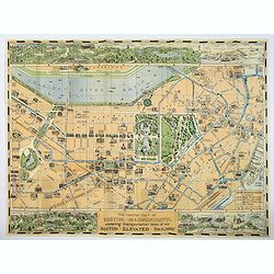
The Central part of Boston, Massachusetts, showing transportation lines of the Boston Elevated Railway.
A very nice folding plan of central Boston, highlighting transportation lines within the city during the 1930's.The two lower corners, and the entire top margin of the ma...
Date: Boston, ca. 1930
Selling price: ????
Please login to see price!
Sold in 2017
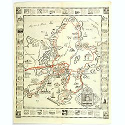
The Cape Ann Trail.
A large folding map of the Cape Ann trail in Massachusetts. The map has 28 red numbered points of reference, which correspond to the small, uncolored vignettes that frame...
Date: Gloucester, 1930
Selling price: ????
Please login to see price!
Sold in 2018
The Creole City of New Orleans.
A large, decorative poster extolling the virtues of the all American city of New Orleans. It extends from Lake Pontchartrain and Spanish Fort, southwards, passing the Bay...
Date: New Orleans, 1930
Selling price: ????
Please login to see price!
Sold in 2018
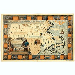
A Map of Olde Boston prepared in commemoration of the Tercentary of Massachusetts Bay Colony 1630-1930.
A double-sided brochure produced to commemorate the 300 year foundation of the Colony of Massachusetts Bay. On one side is the map of Boston, surrounded by contemporary a...
Date: Boston, 1930
Selling price: ????
Please login to see price!
Sold in 2018
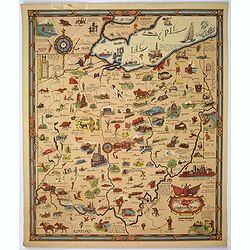
The House Beautiful Old Massachusetts Map of Houses showing their location, type and other information. . .
color pictorial map of Massachusetts, with decorative border showing those oldest homes from colonial and revolutionary houses. Designed by Raymond Lufkin (1899–1978) w...
Date: 1930
Selling price: ????
Please login to see price!
Sold in 2020