Subscribe to be notified if similar examples become available.
Carte des Decouvertes Faites dans lesRegions Arctiques en 1829-33. |
||||||||||||||||||||
|
||||||||||||||||||||
|
|
||||||||||||||||||||
|
Selling price: $ Please login to see price!
Sold in 2017 Missed this item! Add your name to our mailing list and be the first to get notified about our newly added listings. . |
My Collection +
Add this or any of your favorite items in one place. If you want to save the items permanently, you have to sign in or create an account first. |
|||||||||||||||||||
Description
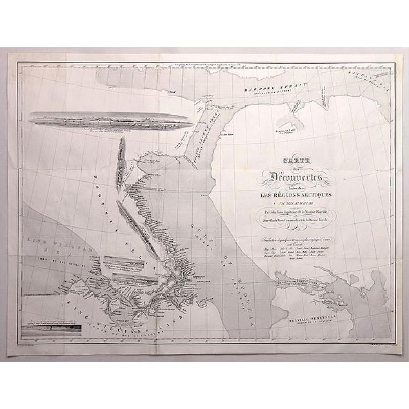
An informative and important map of the discoveries made in the Arctic Regions in 1829-33 by Sir John Ross (1777-1856) in the Hydrographic Office of the Admiralty. Engraved by Charles Schreiber and lithographed by Thierry Freres in Paris in 1835. This map came folded in an unidentified book.
There is no such map for sale (Past or Present) on the Internet. A necessary map for serious collectors of maps regarding “The North West Passage”.
The map has six small views of harbours in various locations on the map. These views are in different positions. I have never seen that on a map.
The map tracks the second expedition of John Ross in Canada’s Northwest Territories, during which Ross discovered King William Island, Boothia Peninsula, and the Gulf of Boothia. Ross named the latter two discoveries after his backer, London gin magnate, Felix Booth. His nephew, James Clark Ross, is credited as the first European to reach the North Magnetic Pole during the same expedition on June 1, 1831.
When the party’s ship was crushed by ice, he and his crew were stranded. The men spent one of the four difficult Arctic winters at "Somerset House," which can be located on the map west of Prince Regent Inlet. This was also the wreck site of the HMS Fury from William Parry’s 1825 expedition.
When Ross and company were finally rescued by whalers in the summer of 1833, the whalers grimly informed Ross that he could not be who he claimed because Captain Ross had died in the Northwest Passage two years earlier. Upon returning to England, Ross was greeted as a hero and knighted the next year. Sir John Ross and his crew’s four winters in the Arctic constituted a survival record that would not be broken for more than seventy years.
FAQ - Guarantee - Shipping
Buying in the BuyNow Gallery
This item is available for immediate purchase when a "Add to Cart" or "Inquire Now" button is shown.
Items are sold in the EU margin scheme
Payments are accepted in Euros or US Dollars.
Authenticity Guarantee
 We provide professional descriptions, condition report (based on 45 years experience in the map business)
Paulus Swaen warrants the authenticity of our items and a certificate of authenticity is provided for each acquired lot.
Condition and Coloring
We indicate the condition of each item and use our unnique HiBCoR grading system in which four key items determine a map's value: Historical Importance, Beauty, Condition/Coloring and Rarity.
Color Key
We offer many maps in their original black and white condition. We do not systematically color-up maps to make them more sellable to the general public or buyer.
Copper engraved or wood block maps are always hand colored. Maps were initially colored for aesthetic reasons and to improve readability. Nowadays, it is becoming a challenge to find maps in their original colors and are therefor more valuable.
We use the following color keys in our catalog:
Original colors; mean that the colors have been applied around the time the map was issued.
Original o/l colors; means the map has only the borders colored at the time of publication.
Colored; If the colors are applied recently or at the end of the 20th century.
Read more about coloring of maps [+]
Shipping fee
A flat shipping fee of $ 30 is added to each shipment by DHL within Europe and North America. This covers : International Priority shipping, Packing and Insurance (up to the invoice amount).
Shipments to Asia are $ 40 and rest of the world $50
We charge only one shipping fee when you have been successful on multiple items or when you want to combine gallery and auction purchases.
Read more about invoicing and shipping
FAQ
Please have a look for more information about buying in the BuyNow gallery
Many answers are likely to find in the general help section.
My Collection+
![]()
With My Collection+ you can collect all your favorite items in one place. It is free, and anyone can create his or her virtual collection.
Unless you are logged in, the item is only saved for this session. You have to be registed and logged-in if you want to save this item permanently to My Collection+.
Read More[+]
Register here, it is free and you do not need a credit card.
Add this item to
My Collection+
or click the following link to see My Collection+.
| Digital Image Download | |
|
Paulus Swaen maintains an archive of most of our high-resolution rare maps, prints, posters and medieval manuscript scans. We make them freely available for download and study. Read more about free image download |
Click the image for a free small image download. |
In accordance with the EU Consumer Rights Directive and habitually reside in the European Union you have the right to cancel the contract for the purchase of a lot, without giving any reason.
The cancellation period will expire 14 calendar days from the day after the date on which you or a third party (other than the carrier and indicated by you) acquires, physical possession of the lot. To exercise the right to cancel you must inform Paulus Swaen Inc, of your decision to cancel this contract by a clear statement (e.g. a letter sent by post, or e-mail.
To meet the cancellation deadline, it is sufficient for you to send your communication concerning your exercise of the right to cancel before the cancellation period has expired.
